BEGIN
NHC_ATCF
invest_al922009.invest
FSTDA
R
U
040
010
0000
200910081443
NONE
NOTIFY
INVEST, AL, L, , , , , 92, 2009, DB, O, 2009100812, 9999999999, , , , , , METWATCH, , AL922009
AL, 92, 2009100712, , BEST, 0, 80N, 473W, 20, 1015, DB, 0, , 0, 0, 0, 0,
AL, 92, 2009100718, , BEST, 0, 84N, 495W, 20, 1015, DB, 0, , 0, 0, 0, 0,
AL, 92, 2009100800, , BEST, 0, 88N, 517W, 25, 1014, DB, 0, , 0, 0, 0, 0,
AL, 92, 2009100806, , BEST, 0, 92N, 542W, 25, 1013, DB, 0, , 0, 0, 0, 0,
AL, 92, 2009100812, , BEST, 0, 93N, 565W, 25, 1013, DB
ftp://ftp.tpc.ncep.noaa.gov/atcf/tcweb/ ... 009.invest
Link to thread about this system at Talking tropics.
viewtopic.php?f=31&t=106794
ATL : INVEST 92L
Moderator: S2k Moderators
-
cycloneye

- Admin

- Posts: 139298
- Age: 67
- Joined: Thu Oct 10, 2002 10:54 am
- Location: San Juan, Puerto Rico
ATL : INVEST 92L
0 likes
Visit the Caribbean-Central America Weather Thread where you can find at first post web cams,radars
and observations from Caribbean basin members Click Here
and observations from Caribbean basin members Click Here
-
cycloneye
- Admin
- Posts: 139298
- Age: 67
- Joined: Thu Oct 10, 2002 10:54 am
- Location: San Juan, Puerto Rico
ATL : INVEST 92L - Models
A low Caribbean rider.
WHXX01 KWBC 081451
CHGHUR
TROPICAL CYCLONE GUIDANCE MESSAGE
NWS TPC/NATIONAL HURRICANE CENTER MIAMI FL
1451 UTC THU OCT 8 2009
DISCLAIMER...NUMERICAL MODELS ARE SUBJECT TO LARGE ERRORS.
PLEASE REFER TO NHC OFFICIAL FORECASTS FOR TROPICAL CYCLONE
AND SUBTROPICAL CYCLONE INFORMATION.
ATLANTIC OBJECTIVE AIDS FOR
DISTURBANCE INVEST (AL922009) 20091008 1200 UTC
...00 HRS... ...12 HRS... ...24 HRS. .. ...36 HRS...
091008 1200 091009 0000 091009 1200 091010 0000
LAT LON LAT LON LAT LON LAT LON
BAMS 9.3N 56.5W 10.1N 60.3W 10.8N 64.0W 11.4N 67.1W
BAMD 9.3N 56.5W 10.4N 60.6W 11.1N 64.3W 11.3N 67.8W
BAMM 9.3N 56.5W 10.2N 60.5W 10.9N 64.3W 11.3N 67.9W
LBAR 9.3N 56.5W 10.3N 60.7W 11.3N 64.5W 11.9N 68.4W
SHIP 25KTS 25KTS 31KTS 40KTS
DSHP 25KTS 25KTS 30KTS 39KTS
...48 HRS... ...72 HRS... ...96 HRS. .. ..120 HRS...
091010 1200 091011 1200 091012 1200 091013 1200
LAT LON LAT LON LAT LON LAT LON
BAMS 11.6N 69.8W 11.0N 75.7W 10.1N 81.4W 9.2N 86.4W
BAMD 11.1N 71.3W 10.2N 78.2W 8.9N 84.3W 7.7N 89.7W
BAMM 11.5N 71.5W 11.3N 78.6W 10.6N 85.3W 9.3N 91.2W
LBAR 12.0N 72.0W 11.6N 77.9W 10.4N 82.4W .0N .0W
SHIP 49KTS 69KTS 87KTS 102KTS
DSHP 43KTS 60KTS 50KTS 67KTS
...INITIAL CONDITIONS...
LATCUR = 9.3N LONCUR = 56.5W DIRCUR = 280DEG SPDCUR = 23KT
LATM12 = 8.8N LONM12 = 51.7W DIRM12 = 280DEG SPDM12 = 24KT
LATM24 = 8.0N LONM24 = 47.3W
WNDCUR = 25KT RMAXWD = 20NM WNDM12 = 25KT
CENPRS = 1013MB OUTPRS = 1014MB OUTRAD = 120NM SDEPTH = D
RD34NE = 0NM RD34SE = 0NM RD34SW = 0NM RD34NW = 0NM
0 likes
Visit the Caribbean-Central America Weather Thread where you can find at first post web cams,radars
and observations from Caribbean basin members Click Here
and observations from Caribbean basin members Click Here


-
cycloneye
- Admin
- Posts: 139298
- Age: 67
- Joined: Thu Oct 10, 2002 10:54 am
- Location: San Juan, Puerto Rico
Re:
artist wrote:where did this come from??
It has been mentioned at the Tropical Weather Outlooks since yesterday morning.
0 likes
Visit the Caribbean-Central America Weather Thread where you can find at first post web cams,radars
and observations from Caribbean basin members Click Here
and observations from Caribbean basin members Click Here
-
wxman57

- Moderator-Pro Met

- Posts: 22484
- Age: 66
- Joined: Sat Jun 21, 2003 8:06 pm
- Location: Houston, TX (southwest)
Re: ATL : INVEST 92L
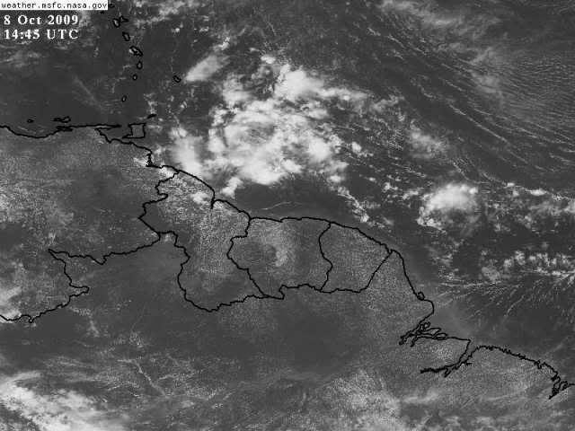
It's the wave that was following Henri, as discussed in "Talkin' Tropics" for the past day or two. Convection flared up a bit today, and there's evidence of mid-level rotation. Development chances are low, as it'll be skirting the coast of South America. Looks more impressive than Henri, though that's not a challenge.
0 likes

Re: ATL : INVEST 92L
Is it a safe bet to say that this will skirt SA and hit CA and not move north due to the strong high to its north.
0 likes

-
Evil Jeremy

- S2K Supporter

- Posts: 5459
- Age: 31
- Joined: Mon Apr 10, 2006 2:10 pm
- Location: Los Angeles, CA
Re: ATL : INVEST 92L
boca wrote:Is it a safe bet to say that this will skirt SA and hit CA and not move north due to the strong high to its north.
Just as safe of a bet it was to say that Fred's circulation would never make it past 70W. Oh, wait...
There is no such thing as a "safe bet" in the tropics in my opinion.
0 likes
Frances 04 / Jeanne 04 / Katrina 05 / Wilma 05 / Fay 08 / Debby 12 / Andrea 13 / Colin 16 / Hermine 16 / Matthew 16 / Irma 17
-
wxman57
- Moderator-Pro Met
- Posts: 22484
- Age: 66
- Joined: Sat Jun 21, 2003 8:06 pm
- Location: Houston, TX (southwest)
Re: ATL : INVEST 92L
Model plot I made. Unusual, to say the least. Would be hard for development to occur on such a track.

0 likes
-
cycloneye
- Admin
- Posts: 139298
- Age: 67
- Joined: Thu Oct 10, 2002 10:54 am
- Location: San Juan, Puerto Rico
Re: ATL : INVEST 92L

0 likes
Visit the Caribbean-Central America Weather Thread where you can find at first post web cams,radars
and observations from Caribbean basin members Click Here
and observations from Caribbean basin members Click Here
-
Blown Away

- S2K Supporter
- Posts: 9867
- Joined: Wed May 26, 2004 6:17 am
Re: ATL : INVEST 92L - Models
How can the SHIP get a 102kt hurricane with that track?
0 likes
Hurricane Eye Experience: David 79, Irene 99, Frances 04, Jeanne 04, Wilma 05... EYE COMING MY WAY IN 2024…
Hurricane Brush Experience: Andrew 92, Erin 95, Floyd 99, Matthew 16, Irma 17, Ian 22, Nicole 22…
Hurricane Brush Experience: Andrew 92, Erin 95, Floyd 99, Matthew 16, Irma 17, Ian 22, Nicole 22…
-
brunota2003

- S2K Supporter
- Posts: 9476
- Age: 33
- Joined: Sat Jul 30, 2005 9:56 pm
- Location: Stanton, KY...formerly Havelock, NC
- Contact:
Re: ATL : INVEST 92L - Models
Blown_away wrote:How can the SHIP get a 102kt hurricane with that track?
SHIPS doesn't account for land interaction. Look at the DSHPS for something more reliable.
0 likes
-
wxman57
- Moderator-Pro Met
- Posts: 22484
- Age: 66
- Joined: Sat Jun 21, 2003 8:06 pm
- Location: Houston, TX (southwest)
Re: ATL : INVEST 92L - Models
Blown_away wrote:How can the SHIP get a 102kt hurricane with that track?
The SHIP model (Statistical Hurricane Intensity Program) does not take into account interactions with or passage over land. The DSHP (D for "Decay") does take into account land interactions.
0 likes
-
cycloneye
- Admin
- Posts: 139298
- Age: 67
- Joined: Thu Oct 10, 2002 10:54 am
- Location: San Juan, Puerto Rico
Re: ATL : INVEST 92L - Models
Shear wont be a problem but interaction with land will.
ftp://ftp.tpc.ncep.noaa.gov/atcf/stext/ ... _ships.txt
Code: Select all
ATLANTIC SHIPS INTENSITY FORECAST       *
                    *      GOES DATA AVAILABLE                  *
                    *      OHC  DATA AVAILABLE                  *
                    *  INVEST      AL922009  10/08/09  12 UTC   *

TIME (HR)          0     6    12    18    24    36    48    60    72    84    96   108   120

SHEAR (KT)         7     4     3     1     3     5    16     5     8     6     7     9     3
ftp://ftp.tpc.ncep.noaa.gov/atcf/stext/ ... _ships.txt
0 likes
Visit the Caribbean-Central America Weather Thread where you can find at first post web cams,radars
and observations from Caribbean basin members Click Here
and observations from Caribbean basin members Click Here

Re: ATL : INVEST 92L - Models
The posts in this forum are NOT official forecast and should not be used as such. They are just the opinion of the poster and may or may not be backed by sound meteorological data. They are NOT endorsed by any professional institution or storm2k.org. For official information, please refer to the NHC and NWS products.
Wow a major hurricane in 120 hours, I don't buy that but it bears watching, conditions won't be that bad in the Caribbean so a tropical sotrm is possible it just needs to move north to avoid interaction with South America and to let Coriolis do its job.
Wow a major hurricane in 120 hours, I don't buy that but it bears watching, conditions won't be that bad in the Caribbean so a tropical sotrm is possible it just needs to move north to avoid interaction with South America and to let Coriolis do its job.
0 likes
-
HURAKAN

- Professional-Met

- Posts: 46086
- Age: 37
- Joined: Thu May 20, 2004 4:34 pm
- Location: Key West, FL
- Contact:
Tropical wave south of Henri
A tropical wave south of Henri, just north of the coast of South America and a few hundred miles east-southeast of the southernmost Lesser Antilles Islands, has grown less organized since yesterday. Both the areal coverage and intensity of the heavy thunderstorm activity has decreased, and there are no signs of organization to the cloud pattern. This wave is under about 10 knots of wind shear, but is too close to the Equator to be able to take advantage of the Earth's spin to help it spin up into a tropical depression very quickly. Also, the wave may pull in some dry, stable air from South America as it scoots just north of the coast over the next few days. NHC is giving this disturbance a low (less than 30% chance) or developing into a tropical depression by Saturday. There are no computer models showing development of this system.
Jeff Masters - http://www.wunderground.com/blog/JeffMa ... rynum=1345
0 likes
-
wxman57
- Moderator-Pro Met
- Posts: 22484
- Age: 66
- Joined: Sat Jun 21, 2003 8:06 pm
- Location: Houston, TX (southwest)
Re: ATL : INVEST 92L
Here's a surface plot. Ignore the ship reporting the northerly wind to the south of the disturbance. Note the pressure (1024mb) and temperature (30F). The ship clearly encoded its observation wrong and is plotted in the wrong location. But pressures are relatively high in the region of the wave, thus it's very rapid westward movement.

0 likes
-
TheEuropean

- Professional-Met
- Posts: 1793
- Age: 58
- Joined: Tue Sep 20, 2005 3:17 pm
- Location: Voerde, Germany
- Contact:
Re: ATL : INVEST 92L
Hi, this was the first thread about this system:
viewtopic.php?f=31&t=106794
Is is possible always to post here a link to the locked discussion thread in Talkin' Tropics in the first post of a new invest? Thx.
viewtopic.php?f=31&t=106794
Is is possible always to post here a link to the locked discussion thread in Talkin' Tropics in the first post of a new invest? Thx.
0 likes

Who is online
Users browsing this forum: No registered users and 20 guests