Tropical Storm Jova Discussion Number 22
NWS National Hurricane Center Miami FL EP112023
800 PM PDT Sat Sep 09 2023
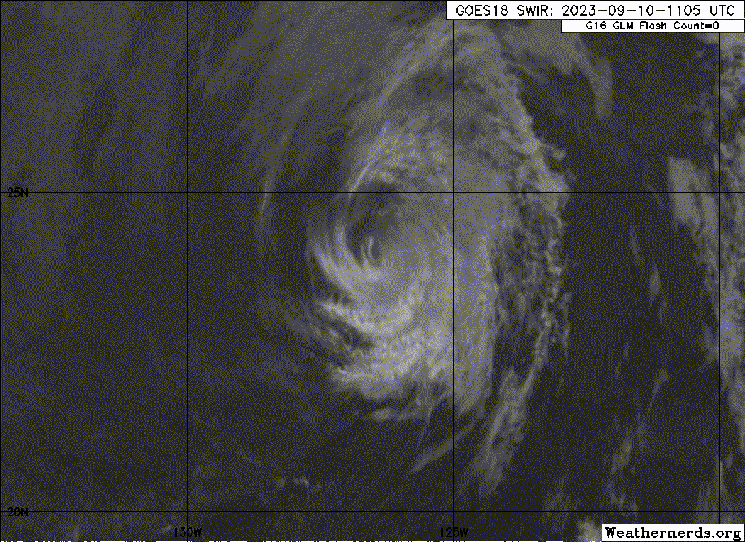
Jova is maintaining some deep convection near the center, and some
shallow convective banding features are still evident over the
southeastern quadrant of the circulation. Since the central
convection has still not decreased much, the current intensity is
held at 45 kt for this advisory. This is above the subjective
Dvorak estimates, but in general agreement with objective ADT values
from UW-CIMSS.
The cyclone continues on a northwestward heading with a motion of
about 315/8 kt, on the western periphery of a mid-level high
pressure area. As the system weakens further, it should be steered
more by the low-level trade wind flow, and turn toward the east and
east-southeast. The official track forecast lies roughly in the
middle of the track guidance suite.
It is a bit surprising the the system has been able to maintain
deep convection this evening. Since the storm will remain over
cooler waters of 23 deg C or lower, however, weakening is likely
and the system should degenerate into a remnant low by Monday.
This is similar to the previous NHC intensity forecast.
FORECAST POSITIONS AND MAX WINDS
INIT 10/0300Z 23.7N 126.5W 45 KT 50 MPH
12H 10/1200Z 24.3N 127.2W 35 KT 40 MPH
24H 11/0000Z 24.8N 128.1W 30 KT 35 MPH
36H 11/1200Z 24.9N 129.0W 25 KT 30 MPH...POST-TROP/REMNT LOW
48H 12/0000Z 24.6N 130.0W 25 KT 30 MPH...POST-TROP/REMNT LOW
60H 12/1200Z 23.9N 131.7W 25 KT 30 MPH...POST-TROP/REMNT LOW
72H 13/0000Z 23.3N 133.6W 25 KT 30 MPH...POST-TROP/REMNT LOW
96H 14/0000Z...DISSIPATED
$$
Forecaster Pasch
NWS National Hurricane Center Miami FL EP112023
800 PM PDT Sat Sep 09 2023
Jova is maintaining some deep convection near the center, and some
shallow convective banding features are still evident over the
southeastern quadrant of the circulation. Since the central
convection has still not decreased much, the current intensity is
held at 45 kt for this advisory. This is above the subjective
Dvorak estimates, but in general agreement with objective ADT values
from UW-CIMSS.
The cyclone continues on a northwestward heading with a motion of
about 315/8 kt, on the western periphery of a mid-level high
pressure area. As the system weakens further, it should be steered
more by the low-level trade wind flow, and turn toward the east and
east-southeast. The official track forecast lies roughly in the
middle of the track guidance suite.
It is a bit surprising the the system has been able to maintain
deep convection this evening. Since the storm will remain over
cooler waters of 23 deg C or lower, however, weakening is likely
and the system should degenerate into a remnant low by Monday.
This is similar to the previous NHC intensity forecast.
FORECAST POSITIONS AND MAX WINDS
INIT 10/0300Z 23.7N 126.5W 45 KT 50 MPH
12H 10/1200Z 24.3N 127.2W 35 KT 40 MPH
24H 11/0000Z 24.8N 128.1W 30 KT 35 MPH
36H 11/1200Z 24.9N 129.0W 25 KT 30 MPH...POST-TROP/REMNT LOW
48H 12/0000Z 24.6N 130.0W 25 KT 30 MPH...POST-TROP/REMNT LOW
60H 12/1200Z 23.9N 131.7W 25 KT 30 MPH...POST-TROP/REMNT LOW
72H 13/0000Z 23.3N 133.6W 25 KT 30 MPH...POST-TROP/REMNT LOW
96H 14/0000Z...DISSIPATED
$$
Forecaster Pasch