
Looks like models are shifting away from 99L in favor of a disturbance further west in the monsoon trough.
https://twitter.com/srmullens/status/1692118790677426184
https://twitter.com/srmullens/status/1692121821875765410
https://twitter.com/srmullens/status/1692121842230685718
ATL: GERT - Models
Moderator: S2k Moderators
-
Blown Away

- S2K Supporter

- Posts: 9867
- Joined: Wed May 26, 2004 6:17 am
Re: ATL: INVEST 99L - Models
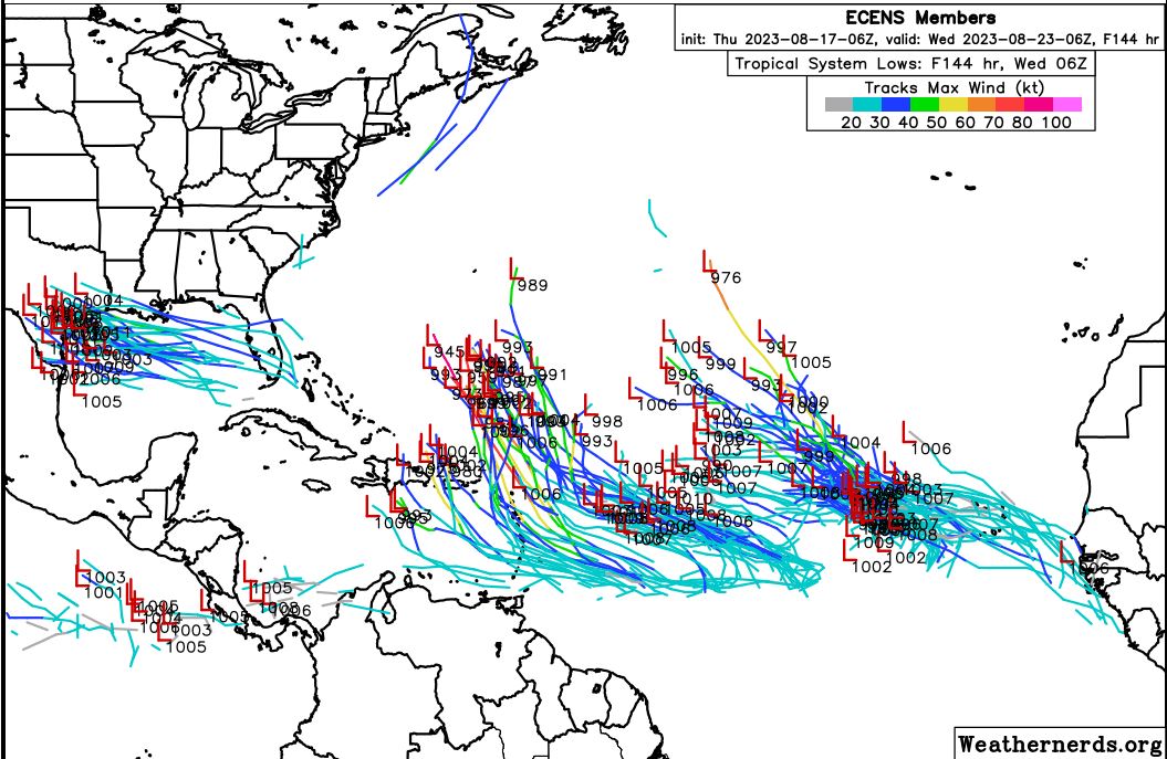
06z ECENS very active... IMO 06z ECENS starting to hint/lean towards the energy consolidating farther W and potentially create a storm that moves into the Caribbean and then N somewhere between 65-80W.
Last edited by Blown Away on Thu Aug 17, 2023 10:27 am, edited 2 times in total.
2 likes
Hurricane Eye Experience: David 79, Irene 99, Frances 04, Jeanne 04, Wilma 05... EYE COMING MY WAY IN 2024…
Hurricane Brush Experience: Andrew 92, Erin 95, Floyd 99, Matthew 16, Irma 17, Ian 22, Nicole 22…
Hurricane Brush Experience: Andrew 92, Erin 95, Floyd 99, Matthew 16, Irma 17, Ian 22, Nicole 22…
Re: ATL: INVEST 99L - Models
12Z UKMET says forms and dissipates in Caribbean:
NEW TROPICAL CYCLONE FORECAST TO DEVELOP AFTER 126 HOURS
FORECAST POSITION AT T+126 : 15.3N 72.4W
LEAD CENTRAL MAXIMUM WIND
VERIFYING TIME TIME POSITION PRESSURE (MB) SPEED (KNOTS)
-------------- ---- -------- ------------- -------------
0000UTC 23.08.2023 132 15.7N 73.1W 1003 32
1200UTC 23.08.2023 144 16.6N 73.6W 1005 33
0000UTC 24.08.2023 156 17.1N 74.3W 1006 28
1200UTC 24.08.2023 168 CEASED TRACKING
0 likes
Personal Forecast Disclaimer:
The posts in this forum are NOT official forecasts and should not be used as such. They are just the opinion of the poster and may or may not be backed by sound meteorological data. They are NOT endorsed by any professional institution or storm2k.org. For official information, please refer to the NHC and NWS products.
The posts in this forum are NOT official forecasts and should not be used as such. They are just the opinion of the poster and may or may not be backed by sound meteorological data. They are NOT endorsed by any professional institution or storm2k.org. For official information, please refer to the NHC and NWS products.
-
Blown Away
- S2K Supporter
- Posts: 9867
- Joined: Wed May 26, 2004 6:17 am
Re: ATL: INVEST 99L - Models
12z CMC... Models seem to be latching on the to the disturbance W of 99L and if so the Caribbean, Bahamas and CONUS could be in play.
0 likes
Hurricane Eye Experience: David 79, Irene 99, Frances 04, Jeanne 04, Wilma 05... EYE COMING MY WAY IN 2024…
Hurricane Brush Experience: Andrew 92, Erin 95, Floyd 99, Matthew 16, Irma 17, Ian 22, Nicole 22…
Hurricane Brush Experience: Andrew 92, Erin 95, Floyd 99, Matthew 16, Irma 17, Ian 22, Nicole 22…
-
SouthFLTropics

- Category 5

- Posts: 4156
- Age: 48
- Joined: Thu Aug 14, 2003 8:04 am
- Location: Port St. Lucie, Florida
Re: ATL: INVEST 99L - Models
Is that a separate disturbance or is that actually 99L that gets into the Caribbean and then develops on the CMC? It is hard to tell one from another with so many potential areas of interest and all of the models doing different things. Tidbits 12Z GFS is stuck on hour 168 but through that time period the GFS doesn't seem to want to develop this like the CMC did.
0 likes
Fourth Generation Floridian...With lots of storm knowledge passed down from my elders...
Personal Storm History: David 79, Andrew 92, Erin 95, Floyd 99, Irene 99, Frances 04, Jeanne 04, Wilma 05, Matthew 16, Irma 17
Personal Storm History: David 79, Andrew 92, Erin 95, Floyd 99, Irene 99, Frances 04, Jeanne 04, Wilma 05, Matthew 16, Irma 17
-
cycloneye

- Admin

- Posts: 139327
- Age: 67
- Joined: Thu Oct 10, 2002 10:54 am
- Location: San Juan, Puerto Rico
Re: ATL: INVEST 99L - Models
Also 12z GFS with the front one.

1 likes
Visit the Caribbean-Central America Weather Thread where you can find at first post web cams,radars
and observations from Caribbean basin members Click Here
and observations from Caribbean basin members Click Here
Re: ATL: INVEST 99L - Models
LarryWx wrote:12Z UKMET says forms and dissipates in Caribbean:
NEW TROPICAL CYCLONE FORECAST TO DEVELOP AFTER 126 HOURS
FORECAST POSITION AT T+126 : 15.3N 72.4W
LEAD CENTRAL MAXIMUM WIND
VERIFYING TIME TIME POSITION PRESSURE (MB) SPEED (KNOTS)
-------------- ---- -------- ------------- -------------
0000UTC 23.08.2023 132 15.7N 73.1W 1003 32
1200UTC 23.08.2023 144 16.6N 73.6W 1005 33
0000UTC 24.08.2023 156 17.1N 74.3W 1006 28
1200UTC 24.08.2023 168 CEASED TRACKING
After a review of other models, I'm thinking this on the 12Z UKMET is actually from a feature west of 99L.
0 likes
Personal Forecast Disclaimer:
The posts in this forum are NOT official forecasts and should not be used as such. They are just the opinion of the poster and may or may not be backed by sound meteorological data. They are NOT endorsed by any professional institution or storm2k.org. For official information, please refer to the NHC and NWS products.
The posts in this forum are NOT official forecasts and should not be used as such. They are just the opinion of the poster and may or may not be backed by sound meteorological data. They are NOT endorsed by any professional institution or storm2k.org. For official information, please refer to the NHC and NWS products.
-
Hurrilurker

- Category 2

- Posts: 638
- Joined: Mon Jun 09, 2003 3:32 pm
- Location: San Francisco, CA
Re: ATL: INVEST 99L - Models
The thing that forms out of nowhere and crosses Cuba looks pretty scary, especially if it goes a couple more degrees west before fully forming. It's not even an invest is it?
2 likes
-
wxman57

- Moderator-Pro Met

- Posts: 22484
- Age: 66
- Joined: Sat Jun 21, 2003 8:06 pm
- Location: Houston, TX (southwest)
Re: ATL: INVEST 99L - Models
SouthFLTropics wrote:Is that a separate disturbance or is that actually 99L that gets into the Caribbean and then develops on the CMC? It is hard to tell one from another with so many potential areas of interest and all of the models doing different things. Tidbits 12Z GFS is stuck on hour 168 but through that time period the GFS doesn't seem to want to develop this like the CMC did.
There is another feature west of 99L that hasn't been identified. Wave is along 48W now. That's the feature that reaches the NE Caribbean on Sunday. There, it'll encounter a wall of shear ahead of a deep TUTT. RIP, wave... I know the 12Z EC has it developing into a TS south of St. Croix Monday morning, but I'm not buying it.
1 likes
-
Blown Away
- S2K Supporter
- Posts: 9867
- Joined: Wed May 26, 2004 6:17 am
Re: ATL: INVEST 99L - Models
12z Euro... Interesting run, TS over PR then finishes with loop in SW Atlantic... EPAC to GOM crossover, whew!
0 likes
Hurricane Eye Experience: David 79, Irene 99, Frances 04, Jeanne 04, Wilma 05... EYE COMING MY WAY IN 2024…
Hurricane Brush Experience: Andrew 92, Erin 95, Floyd 99, Matthew 16, Irma 17, Ian 22, Nicole 22…
Hurricane Brush Experience: Andrew 92, Erin 95, Floyd 99, Matthew 16, Irma 17, Ian 22, Nicole 22…
-
Blown Away
- S2K Supporter
- Posts: 9867
- Joined: Wed May 26, 2004 6:17 am
Re: ATL: INVEST 99L - Models
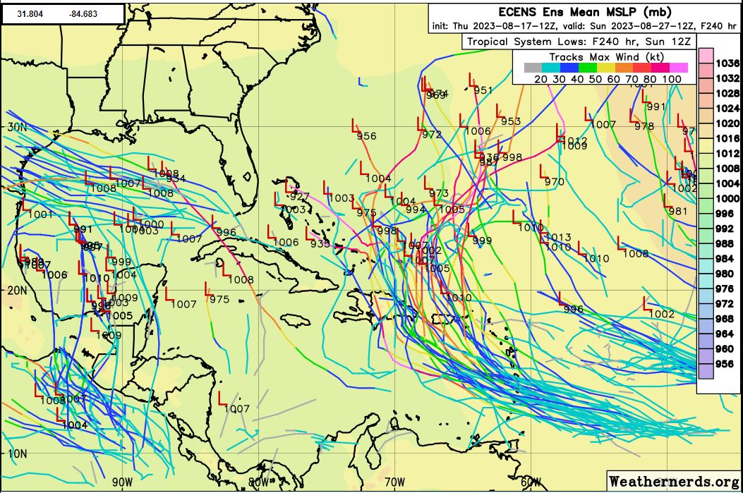
12z ECENS...
0 likes
Hurricane Eye Experience: David 79, Irene 99, Frances 04, Jeanne 04, Wilma 05... EYE COMING MY WAY IN 2024…
Hurricane Brush Experience: Andrew 92, Erin 95, Floyd 99, Matthew 16, Irma 17, Ian 22, Nicole 22…
Hurricane Brush Experience: Andrew 92, Erin 95, Floyd 99, Matthew 16, Irma 17, Ian 22, Nicole 22…
-
AutoPenalti
- Category 5
- Posts: 3949
- Age: 27
- Joined: Mon Aug 17, 2015 4:16 pm
- Location: Ft. Lauderdale, Florida
Re: ATL: INVEST 99L - Models
That one Cat 5 member... yikes.
0 likes
The posts in this forum are NOT official forecasts and should not be used as such. They are just the opinion of the poster and may or may not be backed by sound meteorological data. They are NOT endorsed by any professional institution or STORM2K. For official information, please refer to products from the NHC and NWS.
Model Runs Cheat Sheet:
GFS (5:30 AM/PM, 11:30 AM/PM)
HWRF, GFDL, UKMET, NAVGEM (6:30-8:00 AM/PM, 12:30-2:00 AM/PM)
ECMWF (1:45 AM/PM)
TCVN is a weighted averaged
-
Blown Away
- S2K Supporter
- Posts: 9867
- Joined: Wed May 26, 2004 6:17 am
Re: ATL: INVEST 99L - Models
AutoPenalti wrote:
That one Cat 5 member... yikes.
(2) 936 & 927mb...
0 likes
Hurricane Eye Experience: David 79, Irene 99, Frances 04, Jeanne 04, Wilma 05... EYE COMING MY WAY IN 2024…
Hurricane Brush Experience: Andrew 92, Erin 95, Floyd 99, Matthew 16, Irma 17, Ian 22, Nicole 22…
Hurricane Brush Experience: Andrew 92, Erin 95, Floyd 99, Matthew 16, Irma 17, Ian 22, Nicole 22…
-
Spacecoast

- Category 2
- Posts: 687
- Joined: Thu Aug 31, 2017 2:03 pm


Re: ATL: INVEST 99L - Models
Hurrilurker wrote:The thing that forms out of nowhere and crosses Cuba looks pretty scary, especially if it goes a couple more degrees west before fully forming. It's not even an invest is it?
The Canadian must have caught the ghost storm from the GFS a few runs ago.
Storms in that area do undergo rapid intensification in a favorable environment.
Not sure why both Canadian and GFS had this?
Most of the models have 99L finding a weakness or a major trough, still far out but I'll take that.
1 likes


Re: ATL: GERT - Models
12z Euro actually brings Gert back to life in the subtropics. Of course, it's been very inconsistent in this area. It would be funny, though...

1 likes
-
cycloneye
- Admin
- Posts: 139327
- Age: 67
- Joined: Thu Oct 10, 2002 10:54 am
- Location: San Juan, Puerto Rico
Re: ATL: GERT - Models
Euro has Gert hanging around for a while.

0 likes
Visit the Caribbean-Central America Weather Thread where you can find at first post web cams,radars
and observations from Caribbean basin members Click Here
and observations from Caribbean basin members Click Here
Who is online
Users browsing this forum: No registered users and 19 guests