ATL: INVEST 95L - Models
Moderator: S2k Moderators
-
Iceresistance

- Category 5

- Posts: 8929
- Age: 20
- Joined: Sat Oct 10, 2020 9:45 am
- Location: Tecumseh, OK/Norman, OK
ATL: INVEST 95L - Models
18z GFS wants to have none of this
0 likes
Bill 2015 & Beta 2020
Winter 2020-2021
All observations are in Tecumseh, OK unless otherwise noted.
Winter posts are focused mainly for Oklahoma & Texas.
Take any of my forecasts with a grain of salt, refer to the NWS, SPC, and NHC for official information
Never say Never with weather! Because ANYTHING is possible!
Winter 2020-2021
All observations are in Tecumseh, OK unless otherwise noted.
Winter posts are focused mainly for Oklahoma & Texas.
Take any of my forecasts with a grain of salt, refer to the NWS, SPC, and NHC for official information
Never say Never with weather! Because ANYTHING is possible!
-
Spacecoast

- Category 2

- Posts: 687
- Joined: Thu Aug 31, 2017 2:03 pm

-
Keldeo1997
- Category 2
- Posts: 514
- Joined: Fri Oct 11, 2019 11:35 pm

-
Sciencerocks
- Category 5
- Posts: 7294
- Age: 38
- Joined: Thu Jul 06, 2017 1:51 am

Re: ATL: INVEST 95L - Models
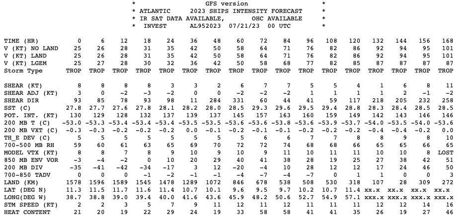
Spacecoast wrote:0z Intensity guidance:
https://i.ibb.co/1960m15/ed6.jpg
I know hurricane models are often unreliable until a system actually forms, but wow. Way more aggressive than I ever imagined.
1 likes
-
REDHurricane

- Tropical Storm

- Posts: 207
- Age: 26
- Joined: Sun Jul 03, 2022 2:36 pm
- Location: Northeast Pacific Ocean
Re: ATL: INVEST 95L - Models
Both the 18z GFS and Euro are showing what should be a relatively favorable environment for development in the next several days, so I'm not too surprised that the hurricane models are optimistic at this point. It'll be interesting to see what the initial HAFS run looks like, too.
Decent looking moisture pocket without much dry air intrusion on both models at +90 hours:


Favorable wind shear environment on both models:


Both models already show increased vorticity around 12N 50W:


Decent looking moisture pocket without much dry air intrusion on both models at +90 hours:
Favorable wind shear environment on both models:
Both models already show increased vorticity around 12N 50W:
0 likes
Re: ATL: INVEST 95L - Discussion


Euro (top) does a much better job on initializing the system than the GFS (bottom).
0 likes


-
Blown Away

- S2K Supporter

- Posts: 9870
- Joined: Wed May 26, 2004 6:17 am
Re: ATL: INVEST 95L - Models
Moving more WNW, deeper system going to gain latitude.
1 likes
Hurricane Eye Experience: David 79, Irene 99, Frances 04, Jeanne 04, Wilma 05... EYE COMING MY WAY IN 2024…
Hurricane Brush Experience: Andrew 92, Erin 95, Floyd 99, Matthew 16, Irma 17, Ian 22, Nicole 22…
Hurricane Brush Experience: Andrew 92, Erin 95, Floyd 99, Matthew 16, Irma 17, Ian 22, Nicole 22…
Re: ATL: INVEST 95L - Models
Blown Away wrote:
Moving more WNW, deeper system going to gain latitude.
And away from the fast easterlies over the Caribbean, which is what EC ensembles that deepen it have been showing, that if it gains latitude as it enters the Caribbean the better chances of it getting stronger.
1 likes
-
Kingarabian

- S2K Supporter
- Posts: 15454
- Joined: Sat Aug 08, 2009 3:06 am
- Location: Honolulu, Hawaii
Re: ATL: INVEST 95L - Models
GEFS members will probably go off. Strongest GFS run in a while.
1 likes
RIP Kobe Bryant
-
cycloneye

- Admin

- Posts: 139493
- Age: 67
- Joined: Thu Oct 10, 2002 10:54 am
- Location: San Juan, Puerto Rico
Re: ATL: INVEST 95L - Models
Survives the track thru Hispañola.
0 likes
Visit the Caribbean-Central America Weather Thread where you can find at first post web cams,radars
and observations from Caribbean basin members Click Here
and observations from Caribbean basin members Click Here
Re: ATL: INVEST 95L - Models
cycloneye wrote:Survives the track thru Hispañola.
With a very good UL environment.
1 likes
-
Blown Away
- S2K Supporter
- Posts: 9870
- Joined: Wed May 26, 2004 6:17 am
Re: ATL: INVEST 95L - Models
NDG wrote:cycloneye wrote:Survives the track thru Hispañola.
With a very good UL environment.
NHC 7 day cone ends E of the Islands and this GFS run seemed faster with 95L near PR/Hispaniola in @7 days.
0 likes
Hurricane Eye Experience: David 79, Irene 99, Frances 04, Jeanne 04, Wilma 05... EYE COMING MY WAY IN 2024…
Hurricane Brush Experience: Andrew 92, Erin 95, Floyd 99, Matthew 16, Irma 17, Ian 22, Nicole 22…
Hurricane Brush Experience: Andrew 92, Erin 95, Floyd 99, Matthew 16, Irma 17, Ian 22, Nicole 22…
Re: ATL: INVEST 95L - Models
Blown Away wrote:NDG wrote:cycloneye wrote:Survives the track thru Hispañola.
With a very good UL environment.
NHC 7 day cone ends E of the Islands and this GFS run seemed faster with 95L near PR/Hispaniola in @7 days.
The NHC cone on TWOs indicates the region where genesis may take place, not where the storm will be after genesis. In other words, the cone is saying that if 95L doesn't develop east of the islands, it probably won't develop after passing the islands. That doesn't mean an established system won't reach as far as the Eastern Caribbean within 7 days.
1 likes
-
Blown Away
- S2K Supporter
- Posts: 9870
- Joined: Wed May 26, 2004 6:17 am
Re: ATL: INVEST 95L - Models
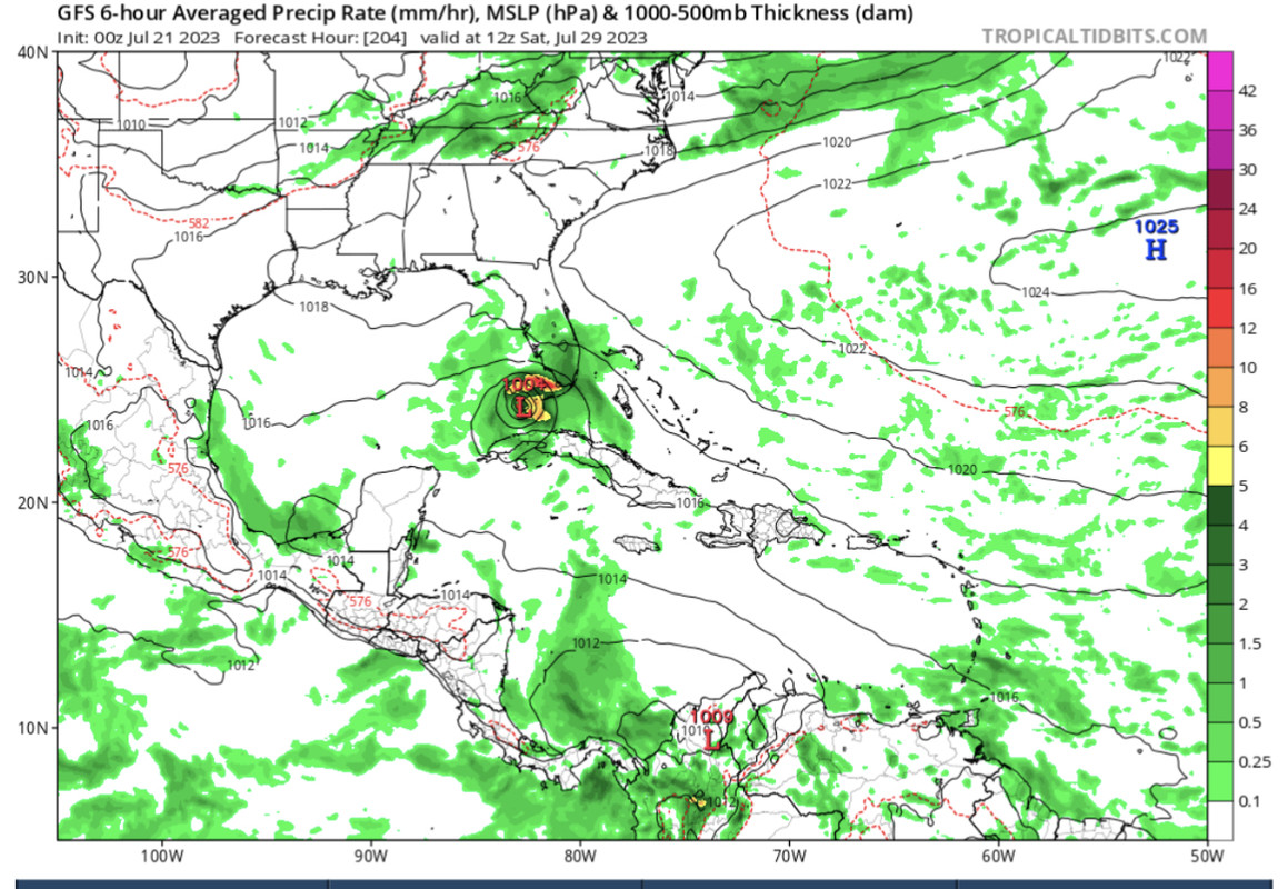
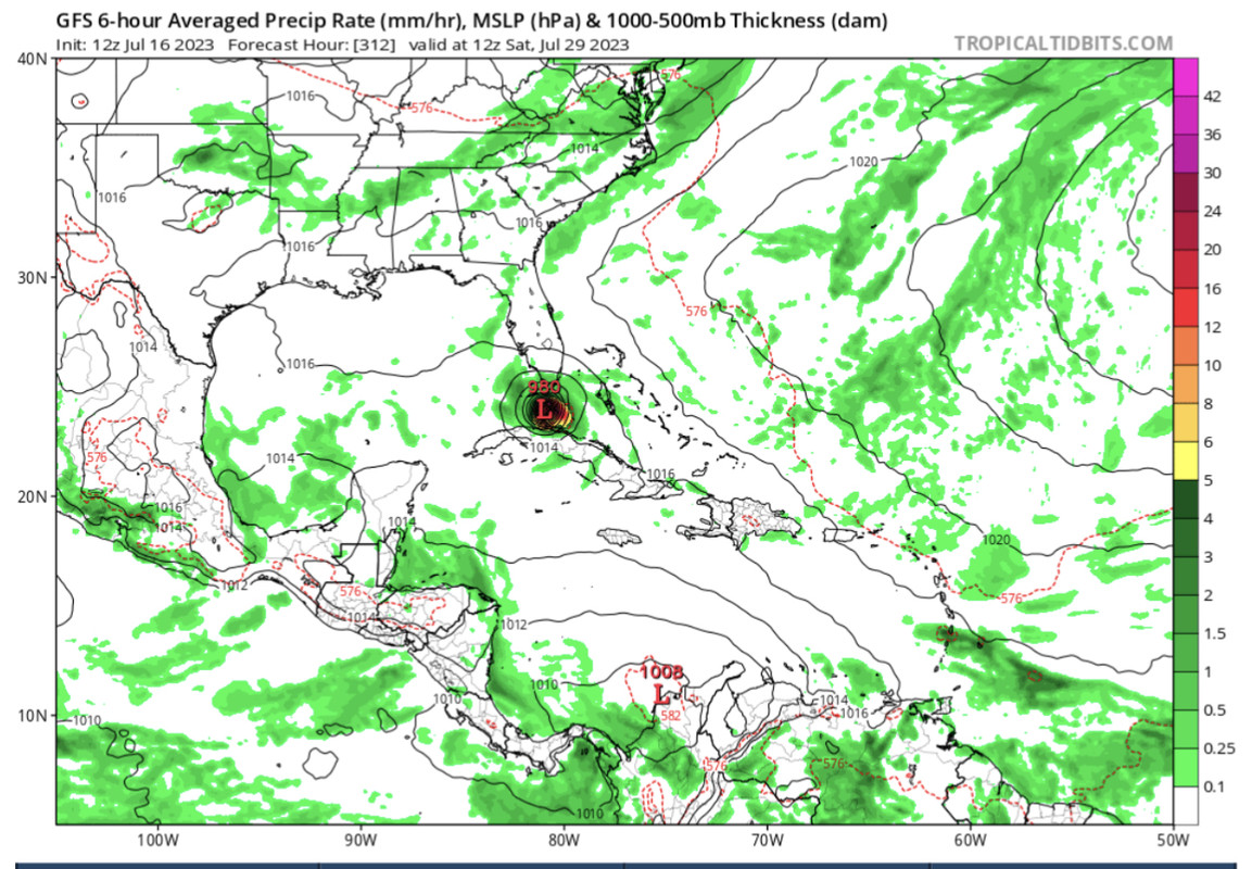
JULY 21st GFS 00z - Over KW on July 29th…
JULY 16th GFS 12z - Over KW on July 29th…
GFS keeps hinting at the same pattern…
1 likes
Hurricane Eye Experience: David 79, Irene 99, Frances 04, Jeanne 04, Wilma 05... EYE COMING MY WAY IN 2024…
Hurricane Brush Experience: Andrew 92, Erin 95, Floyd 99, Matthew 16, Irma 17, Ian 22, Nicole 22…
Hurricane Brush Experience: Andrew 92, Erin 95, Floyd 99, Matthew 16, Irma 17, Ian 22, Nicole 22…
-
Kingarabian
- S2K Supporter
- Posts: 15454
- Joined: Sat Aug 08, 2009 3:06 am
- Location: Honolulu, Hawaii
-
Blown Away
- S2K Supporter
- Posts: 9870
- Joined: Wed May 26, 2004 6:17 am
Re: ATL: INVEST 95L - Models
Kingarabian wrote:LA/MS border it looks like as a MH.
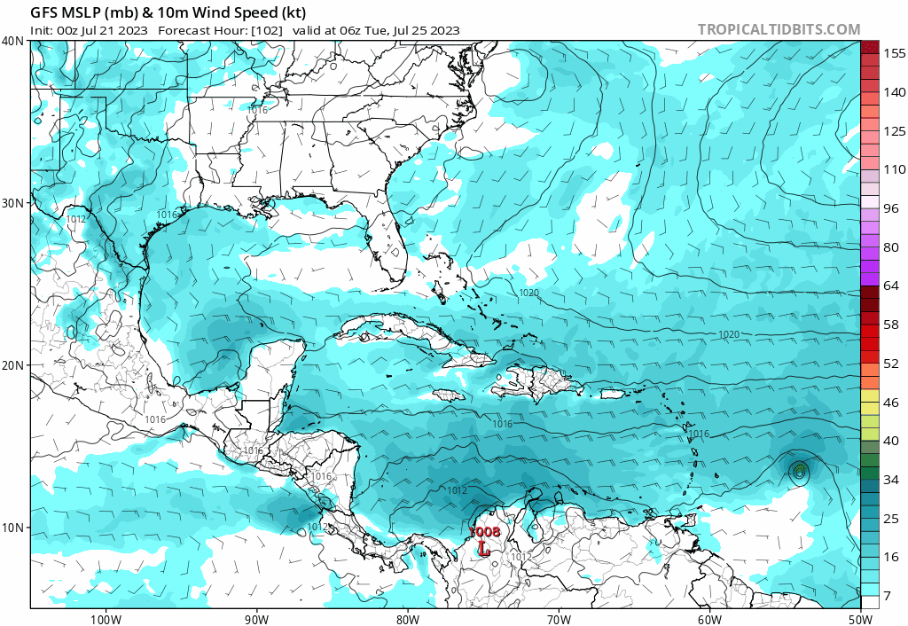
00z GFS
1 likes
Hurricane Eye Experience: David 79, Irene 99, Frances 04, Jeanne 04, Wilma 05... EYE COMING MY WAY IN 2024…
Hurricane Brush Experience: Andrew 92, Erin 95, Floyd 99, Matthew 16, Irma 17, Ian 22, Nicole 22…
Hurricane Brush Experience: Andrew 92, Erin 95, Floyd 99, Matthew 16, Irma 17, Ian 22, Nicole 22…
Re: ATL: INVEST 95L - Models
While this is not in La La Land (the Gulf landfall is in 11 days), short-tern track and intensity can have significant impacts down the road. This run goes right through Hispaniola, but slight deviations can result in anything from dissipation in the Caribbean to a FL landfall or possibly even OTS. Of course, the system may also not get nearly as strong in the short term (thus dissipate even before the islands) or not even develop at all.
1 likes

Re: ATL: INVEST 95L - Models
If this survives and goes just north of Haiti instead, south Florida might have some serious problems. 90 degree waters around the Bahamas.
0 likes
Who is online
Users browsing this forum: Google [Bot] and 5 guests