ATL: CINDY - Models

Moderator: S2k Moderators

Message
Author
zzzh
Category 2
Category 2
Posts: 547
Joined: Thu Sep 02, 2021 1:13 pm

ATL: CINDY - Models

#1 Postby zzzh » Mon Jun 19, 2023 1:09 pm

Image
Euro has it a TD/TS in 48h :lol:
3 likes   

AutoPenalti
Category 5
Category 5
Posts: 3949
Age: 27
Joined: Mon Aug 17, 2015 4:16 pm
Location: Ft. Lauderdale, Florida

Re: ATL: INVEST 93L - Models

#2 Postby AutoPenalti » Mon Jun 19, 2023 1:22 pm

0 likes   
The posts in this forum are NOT official forecasts and should not be used as such. They are just the opinion of the poster and may or may not be backed by sound meteorological data. They are NOT endorsed by any professional institution or STORM2K. For official information, please refer to products from the NHC and NWS.


Model Runs Cheat Sheet:
GFS (5:30 AM/PM, 11:30 AM/PM)
HWRF, GFDL, UKMET, NAVGEM (6:30-8:00 AM/PM, 12:30-2:00 AM/PM)
ECMWF (1:45 AM/PM)

TCVN
is a weighted averaged

User avatar
NDG
S2K Supporter
S2K Supporter
Posts: 14933
Joined: Sun Jul 09, 2006 10:14 pm
Location: Orlando, FL

Re: ATL: INVEST 93L - Models

#3 Postby NDG » Mon Jun 19, 2023 1:40 pm

12z Euro really likes 93L, better than TD3, at least in the short term.

Image
0 likes   

User avatar
Nimbus
Category 5
Category 5
Posts: 4928
Joined: Mon Jul 19, 2004 10:54 am

Re: ATL: INVEST 93L - Models

#4 Postby Nimbus » Mon Jun 19, 2023 2:04 pm

NDG wrote:12z Euro really likes 93L, better than TD3, at least in the short term.

https://i.imgur.com/ZuR1B08.gif


And 93L is recurving before the islands so they may not need the 72 hour warnings.
0 likes   

User avatar
Teban54
Category 5
Category 5
Posts: 1974
Joined: Sat May 19, 2018 1:19 pm

Re: ATL: INVEST 93L - Models

#5 Postby Teban54 » Mon Jun 19, 2023 9:36 pm

Both HAFS models really like this one. The 18z HAFS-A peaks 93L at 976 mb in the MDR (and Bret at 966), and the HAFS-B peaks 93L at 975 mb (and Bret at 986).
1 likes   

User avatar
ElectricStorm
Category 5
Category 5
Posts: 4597
Age: 23
Joined: Tue Aug 13, 2019 11:23 pm
Location: Skiatook, OK / Norman, OK

Re: ATL: INVEST 93L - Models

#6 Postby ElectricStorm » Wed Jun 21, 2023 2:00 am

All 4 hurricane models 0z runs bring this to hurricane strength, although both HAFS models randomly jump from TS to hurricane and back to TS in the matter of hours especially HAFS-A so I'm not sure those are really believable right now. I'm skeptical this can become a hurricane in June but since 2 June MDR are storms is already pretty much unprecedented I guess all bets are off at this point.
Looks like models are pointing towards a recurve so if that's the case it would be nice to see this make a run for hurricane status.
0 likes   
I am in no way a professional. Take what I say with a grain of salt as I could be totally wrong. Please refer to the NHC, NWS, or SPC for official information.

Boomer Sooner!

User avatar
Hurricane2022
Category 4
Category 4
Posts: 945
Joined: Tue Aug 23, 2022 11:38 pm
Location: Araçatuba, Brazil

Re: ATL: INVEST 93L - Models

#7 Postby Hurricane2022 » Wed Jun 21, 2023 1:57 pm

Image
Image
HWRF wants a strong hurricane from 93L, while HAFS A & B only shows a moderate and sheared tropical storm
1 likes   
Sorry for the bad English sometimes...!
For reliable and detailed information for any meteorological phenomenon, please consult the National Hurricane Center, Joint Typhoon Warning Center , or your local Meteo Center.

--------

Una cvm Christo, pro Christo, et in Christo. Sit nomen Domini benedictvm.

User avatar
Hurricane2022
Category 4
Category 4
Posts: 945
Joined: Tue Aug 23, 2022 11:38 pm
Location: Araçatuba, Brazil

Re: ATL: INVEST 93L - Models

#8 Postby Hurricane2022 » Wed Jun 21, 2023 1:59 pm

Hurricane2022 wrote:https://imageshack.com/i/po5kU2sTp
https://imageshack.com/i/pob9ictzp
HWRF wants a strong hurricane from 93L, while HAFS A & B only shows a moderate and sheared tropical storm

Image
Image
:lol:
2 likes   
Sorry for the bad English sometimes...!
For reliable and detailed information for any meteorological phenomenon, please consult the National Hurricane Center, Joint Typhoon Warning Center , or your local Meteo Center.

--------

Una cvm Christo, pro Christo, et in Christo. Sit nomen Domini benedictvm.

User avatar
Hypercane_Kyle
Category 5
Category 5
Posts: 2900
Joined: Sat Mar 07, 2015 7:58 pm
Location: Cape Canaveral, FL

Re: ATL: CINDY - Models

#9 Postby Hypercane_Kyle » Thu Jun 22, 2023 11:14 pm

00z GFS back in the hurricane camp in about six days.
0 likes   
My posts are my own personal opinion, defer to the National Hurricane Center (NHC) and other NOAA products for decision making during hurricane season.

User avatar
Teban54
Category 5
Category 5
Posts: 1974
Joined: Sat May 19, 2018 1:19 pm

Re: ATL: CINDY - Models

#10 Postby Teban54 » Thu Jun 22, 2023 11:56 pm

Hypercane_Kyle wrote:00z GFS back in the hurricane camp in about six days.

Image
0 likes   

User avatar
aspen
Category 5
Category 5
Posts: 8057
Joined: Sat Oct 12, 2019 7:10 pm
Location: Connecticut, USA

Re: ATL: CINDY - Models

#11 Postby aspen » Fri Jun 23, 2023 6:19 am

00z and 06z GFS runs show Cindy surviving a period of high shear in a few days and re-intensifying into a hurricane in the subtropics. The only other global model with a remotely similar scenario is the 00z ICON, which is much weaker.
0 likes   
Irene '11 Sandy '12 Hermine '16 5/15/2018 Derecho Fay '20 Isaias '20 Elsa '21 Henri '21 Ida '21

I am only a meteorology enthusiast who knows a decent amount about tropical cyclones. Look to the professional mets, the NHC, or your local weather office for the best information.

BobHarlem
Category 5
Category 5
Posts: 1665
Joined: Thu Oct 20, 2005 6:11 pm

Re: ATL: CINDY - Models

#12 Postby BobHarlem » Fri Jun 23, 2023 10:40 am

1 likes   

zzzh
Category 2
Category 2
Posts: 547
Joined: Thu Sep 02, 2021 1:13 pm

Re: ATL: CINDY - Models

#13 Postby zzzh » Fri Jun 23, 2023 2:00 pm

12z ec shows it redeveloping in the subtropics.
0 likes   

BobHarlem
Category 5
Category 5
Posts: 1665
Joined: Thu Oct 20, 2005 6:11 pm

Re: ATL: CINDY - Models

#14 Postby BobHarlem » Fri Jun 23, 2023 2:48 pm

Cindy's Euro Ensembles are clumped to the west of Bermuda
Image

GFS ensembles clumped to the east.

Image

Mostly on the weak side, but a few get to hurricane strength.
0 likes   

User avatar
aspen
Category 5
Category 5
Posts: 8057
Joined: Sat Oct 12, 2019 7:10 pm
Location: Connecticut, USA

Re: ATL: CINDY - Models

#15 Postby aspen » Fri Jun 23, 2023 7:49 pm

The only global model that doesn’t show Cindy recovering/re-developing in the subtropics is the CMC. The GFS has been doing so for multiple runs, and the Euro and ICON hopped on board today.
0 likes   
Irene '11 Sandy '12 Hermine '16 5/15/2018 Derecho Fay '20 Isaias '20 Elsa '21 Henri '21 Ida '21

I am only a meteorology enthusiast who knows a decent amount about tropical cyclones. Look to the professional mets, the NHC, or your local weather office for the best information.

User avatar
ScottNAtlanta
Category 5
Category 5
Posts: 2006
Joined: Sat May 25, 2013 3:11 pm
Location: Atlanta, GA

Re: ATL: CINDY - Models

#16 Postby ScottNAtlanta » Fri Jun 23, 2023 8:36 pm

Ok, who has June Tropical Cyclone hitting Atlantic Canada on their BINGO card?

Image
1 likes   
The posts in this forum are NOT official forecast and should not be used as such. They are just the opinion of the poster and may or may not be backed by sound meteorological data. They are NOT endorsed by any professional institution or storm2k.org. For official information, please refer to the NHC and NWS products.

User avatar
cycloneye
Admin
Admin
Posts: 139328
Age: 67
Joined: Thu Oct 10, 2002 10:54 am
Location: San Juan, Puerto Rico

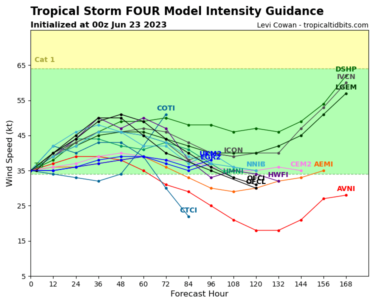
Re: ATL: CINDY - Models

#17 Postby cycloneye » Fri Jun 23, 2023 9:27 pm

More models extend Cindy's tenure as a storm.

Image
0 likes   
Visit the Caribbean-Central America Weather Thread where you can find at first post web cams,radars
and observations from Caribbean basin members Click Here

IcyTundra
Category 3
Category 3
Posts: 889
Joined: Mon Jun 07, 2021 9:32 pm
Location: Dickinson, Texas

Re: ATL: CINDY - Models

#18 Postby IcyTundra » Fri Jun 23, 2023 10:58 pm

0Z GFS coming in a lot stronger.
0 likes   

User avatar
Kazmit
Category 5
Category 5
Posts: 1915
Age: 21
Joined: Mon Jul 25, 2016 8:49 am
Location: Williamsburg VA for college, Bermuda otherwise

Re: ATL: CINDY - Models

#19 Postby Kazmit » Sat Jun 24, 2023 8:03 am

GFS seems very persistent on making this a hurricane later on and bringing it close to Bermuda. NHC doesn’t buy it yet, can’t blame them.
0 likes   
Igor 2010, Sandy 2012, Fay 2014, Gonzalo 2014, Joaquin 2015, Nicole 2016, Humberto 2019

I am only a tropical weather enthusiast. My predictions are not official and may or may not be backed by sound meteorological data. For official information, please refer to the NHC and NWS products.

User avatar
Teban54
Category 5
Category 5
Posts: 1974
Joined: Sat May 19, 2018 1:19 pm

Re: ATL: CINDY - Models

#20 Postby Teban54 » Sat Jun 24, 2023 9:34 am

0 likes   


Return to “2023”

Who is online

Users browsing this forum: No registered users and 25 guests