ATL: BRET - Remnants - Discussion

Moderator: S2k Moderators

Message
Author
User avatar
cycloneye
Admin
Admin
Posts: 139492
Age: 67
Joined: Thu Oct 10, 2002 10:54 am
Location: San Juan, Puerto Rico

ATL: BRET - Remnants - Discussion

#1 Postby cycloneye » Fri Jun 16, 2023 7:36 pm

AL, 92, 2023061700, , BEST, 0, 100N, 252W, 20, 1011, WV, 34, NEQ, 0, 0, 0, 0, 1013, 100, 70, 0, 0, L, 0, , 0, 0, INVEST, S, 0, , 0, 0, 0, 0, genesis-num, 007, SPAWNINVEST, al772023 to al922023


https://ftp.nhc.noaa.gov/atcf/btk/bal922023.dat


https://ftp.nhc.noaa.gov/atcf/btk/
3 likes   
Visit the Caribbean-Central America Weather Thread where you can find at first post web cams,radars
and observations from Caribbean basin members Click Here

User avatar
ElectricStorm
Category 5
Category 5
Posts: 4618
Age: 23
Joined: Tue Aug 13, 2019 11:23 pm
Location: Skiatook, OK / Norman, OK

Re: ATL: INVEST 92L - Discussion

#2 Postby ElectricStorm » Fri Jun 16, 2023 7:56 pm

Well this will be interesting to track in June. Could be a sign of things to come...
0 likes   
I am in no way a professional. Take what I say with a grain of salt as I could be totally wrong. Please refer to the NHC, NWS, or SPC for official information.

Boomer Sooner!

User avatar
weeniepatrol
Category 3
Category 3
Posts: 869
Joined: Sat Aug 22, 2020 5:30 pm
Location: WA State

Re: ATL: INVEST 92L - Discussion

#3 Postby weeniepatrol » Fri Jun 16, 2023 7:56 pm

1 likes   

User avatar
Category5Kaiju
Category 5
Category 5
Posts: 3417
Age: 22
Joined: Thu Dec 24, 2020 12:45 pm
Location: Seattle

Re: ATL: INVEST 92L - Discussion

#4 Postby Category5Kaiju » Fri Jun 16, 2023 7:56 pm

This is going to be a wild thread. While I myself may be currently in Seattle and very far from the tropics, I'm honestly very curious to see how this entire, quite unparalleled situation unfolds and how close this new system gets to the Lesser Antilles.
5 likes   
Unless explicitly stated, all information covered in my posts is based on my opinions and observations. Please refer to a professional meteorologist or an accredited weather research agency otherwise, especially if serious decisions must be made in the event of a potentially life-threatening tropical storm or hurricane.

zzzh
Category 2
Category 2
Posts: 553
Joined: Thu Sep 02, 2021 1:13 pm

Re: ATL: INVEST 92L - Discussion

#5 Postby zzzh » Fri Jun 16, 2023 8:10 pm

Image
Well, this is consolidating faster than I thought.
4 likes   

Sciencerocks
Category 5
Category 5
Posts: 7294
Age: 38
Joined: Thu Jul 06, 2017 1:51 am

Re: ATL: INVEST 92L - Discussion

#6 Postby Sciencerocks » Fri Jun 16, 2023 8:27 pm

Image
1 likes   

User avatar
GCANE
S2K Supporter
S2K Supporter
Posts: 10787
Joined: Mon Oct 22, 2007 8:03 am

Re: ATL: INVEST 92L - Discussion

#7 Postby GCANE » Fri Jun 16, 2023 8:36 pm

This won't be picking up high CAPE air or high TPW air from the Amazon until it gets to 50W.
SAL is pretty strong.
ICON and Euro keep it weak until then.
GFS is the outlier with it strengthening before then.
0 likes   

User avatar
Blown Away
S2K Supporter
S2K Supporter
Posts: 9870
Joined: Wed May 26, 2004 6:17 am

ATL: INVEST 92L - Models

#8 Postby Blown Away » Fri Jun 16, 2023 8:40 pm

Image

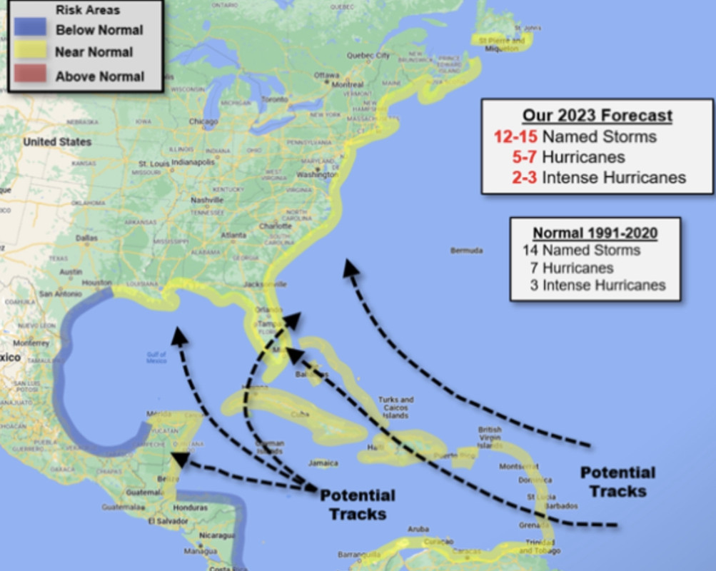
I believe this map is Wxman57’s prediction for the season. 92L likely following a track close to what he is predicting. Stronger goes N earlier, weaker goes S into Caribbean.
0 likes   
Hurricane Eye Experience: David 79, Irene 99, Frances 04, Jeanne 04, Wilma 05... EYE COMING MY WAY IN 2024…
Hurricane Brush Experience: Andrew 92, Erin 95, Floyd 99, Matthew 16, Irma 17, Ian 22, Nicole 22…

User avatar
cycloneye
Admin
Admin
Posts: 139492
Age: 67
Joined: Thu Oct 10, 2002 10:54 am
Location: San Juan, Puerto Rico

Re: ATL: INVEST 92L - Discussion

#9 Postby cycloneye » Fri Jun 16, 2023 8:46 pm

0 likes   
Visit the Caribbean-Central America Weather Thread where you can find at first post web cams,radars
and observations from Caribbean basin members Click Here

User avatar
weeniepatrol
Category 3
Category 3
Posts: 869
Joined: Sat Aug 22, 2020 5:30 pm
Location: WA State

Re: ATL: INVEST 92L - Discussion

#10 Postby weeniepatrol » Fri Jun 16, 2023 8:47 pm

3 likes   

User avatar
msbee
S2K Supporter
S2K Supporter
Posts: 3010
Joined: Wed Jun 11, 2003 10:11 am
Location: St. Maarten

Re: ATL: INVEST 92L - Discussion

#11 Postby msbee » Fri Jun 16, 2023 8:56 pm

And it has begun! :roll:
Hope it gives us some rain.
6 likes   
Too many hurricanes to remember

User avatar
cycloneye
Admin
Admin
Posts: 139492
Age: 67
Joined: Thu Oct 10, 2002 10:54 am
Location: San Juan, Puerto Rico

Re: ATL: INVEST 92L - Discussion

#12 Postby cycloneye » Fri Jun 16, 2023 9:00 pm

msbee wrote:And it has begun! :roll:
Hope it gives us some rain.


Hi Barbara. Yes, dont want a hurricane in any of the islands. Go fishing.
4 likes   
Visit the Caribbean-Central America Weather Thread where you can find at first post web cams,radars
and observations from Caribbean basin members Click Here

Sciencerocks
Category 5
Category 5
Posts: 7294
Age: 38
Joined: Thu Jul 06, 2017 1:51 am

Re: ATL: INVEST 92L - Discussion

#13 Postby Sciencerocks » Fri Jun 16, 2023 9:01 pm

0 likes   

User avatar
aspen
Category 5
Category 5
Posts: 8059
Joined: Sat Oct 12, 2019 7:10 pm
Location: Connecticut, USA

Re: ATL: INVEST 92L - Discussion

#14 Postby aspen » Fri Jun 16, 2023 9:03 pm

It’s not even the official start of summer yet, and we already have an invest in the MDR that might become a hurricane later on….during a developing El Niño. The heck is going on with this year lol.
3 likes   
Irene '11 Sandy '12 Hermine '16 5/15/2018 Derecho Fay '20 Isaias '20 Elsa '21 Henri '21 Ida '21

I am only a meteorology enthusiast who knows a decent amount about tropical cyclones. Look to the professional mets, the NHC, or your local weather office for the best information.

Sciencerocks
Category 5
Category 5
Posts: 7294
Age: 38
Joined: Thu Jul 06, 2017 1:51 am

Re: ATL: INVEST 92L - Discussion

#15 Postby Sciencerocks » Fri Jun 16, 2023 9:05 pm

aspen wrote:It’s not even the official start of summer yet, and we already have an invest in the MDR that might become a hurricane later on….during a developing El Niño. The heck is going on with this year lol.


Nino's trend to start fast and then shut down. We can pump out the majority of the storms early in the season before the shear slams the door. Probably the opposite will happen in teh eastern Pacific as the backend of that season could be very active and which will induce the shear over teh Atlantic.
1 likes   

User avatar
Category5Kaiju
Category 5
Category 5
Posts: 3417
Age: 22
Joined: Thu Dec 24, 2020 12:45 pm
Location: Seattle

Re: ATL: INVEST 92L - Discussion

#16 Postby Category5Kaiju » Fri Jun 16, 2023 9:24 pm


So let's review. We have record warm sst anomalies (to the point one may look at the current environment and think the ocean is in August or September). Combine that with a strong +AMO and -NAO keeping trades weak, as well as abnormally low levels of SAL. Oh yeah, and not to mention, a -PDO/-PMM that is keeping the EPAC unusually quiet despite a classic El Nino beginning to come into effect. Ah yes, and add an active West African monsoon into the mix.

I know it's June, but...
Image
:lol:
15 likes   
Unless explicitly stated, all information covered in my posts is based on my opinions and observations. Please refer to a professional meteorologist or an accredited weather research agency otherwise, especially if serious decisions must be made in the event of a potentially life-threatening tropical storm or hurricane.

Sciencerocks
Category 5
Category 5
Posts: 7294
Age: 38
Joined: Thu Jul 06, 2017 1:51 am

Re: ATL: INVEST 92L - Discussion

#17 Postby Sciencerocks » Fri Jun 16, 2023 11:27 pm

Image
2 likes   

User avatar
ElectricStorm
Category 5
Category 5
Posts: 4618
Age: 23
Joined: Tue Aug 13, 2019 11:23 pm
Location: Skiatook, OK / Norman, OK

Re: ATL: INVEST 92L - Discussion

#18 Postby ElectricStorm » Sat Jun 17, 2023 12:36 am

Tropical Weather Outlook
NWS National Hurricane Center Miami FL
200 AM EDT Sat Jun 17 2023

For the North Atlantic...Caribbean Sea and the Gulf of Mexico:

1. Eastern Tropical Atlantic (AL92):
A tropical wave located several hundred miles south-southwest of the
Cabo Verde Islands continues to produce a broad area of disorganized
showers and thunderstorms. Environmental conditions appear conducive
for additional development, and a tropical depression is likely to
form by the early to middle portion of next week while the system
moves westward at 15 to 20 mph across the eastern and central
tropical Atlantic.
* Formation chance through 48 hours...medium...40 percent.
* Formation chance through 7 days...high...70 percent.

Forecaster Papin
2 likes   
I am in no way a professional. Take what I say with a grain of salt as I could be totally wrong. Please refer to the NHC, NWS, or SPC for official information.

Boomer Sooner!

Sciencerocks
Category 5
Category 5
Posts: 7294
Age: 38
Joined: Thu Jul 06, 2017 1:51 am

Re: ATL: INVEST 92L - Discussion

#19 Postby Sciencerocks » Sat Jun 17, 2023 12:49 am

1. I think this probably stays at a reasonable strength as conditions will likely not be quite as favorable with dry air + more wind shear. Sure the eastern Atlantic is far more favorable then normal, but it isn't going to likely produce a cat3-4 unlike what the hurricane intensity models are suggesting.
2. The ridging will be stronger and drive the system towards the islands. I'd watch this closely!
3. I think 55-65 knots is likely the peak intensity within the next 7 days...
4. I don't believe this will be a threat to the united states as the break in the ridging at 70-75 west will likely suck it upwards and recurve it out to sea after threatening the islands and Puerto rico.

wait and see.
3 likes   

USTropics
Category 5
Category 5
Posts: 2420
Joined: Sun Aug 12, 2007 3:45 am
Location: Florida State University

Re: ATL: INVEST 92L - Discussion

#20 Postby USTropics » Sat Jun 17, 2023 12:57 am

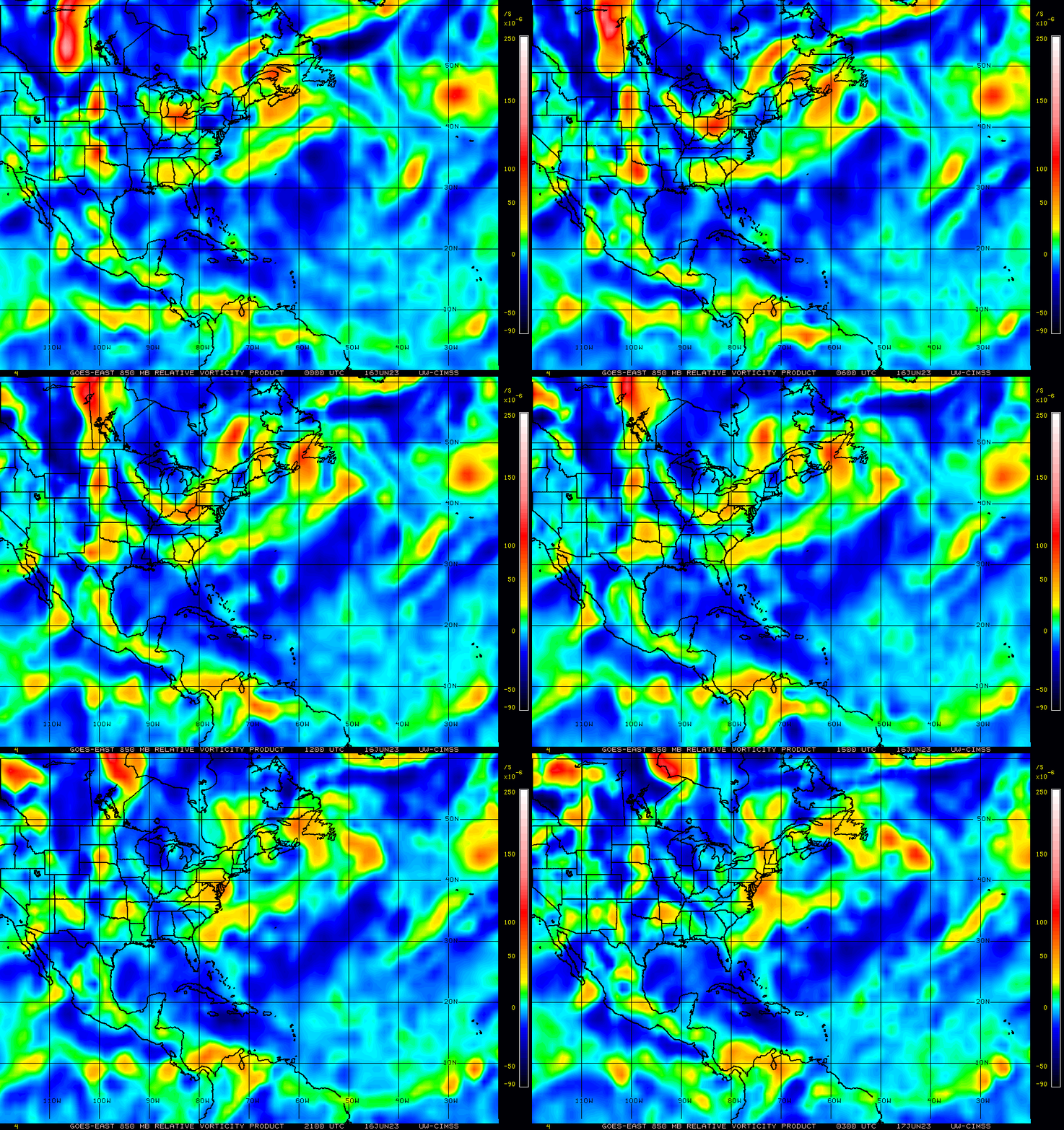
Follow the low-level vorticity for now, we'll need these two low-level vort lobes to consolidate. The most likely scenario is for the SW lobe to pivot towards the NE with consolidation in 24-48 hours from now:
Image

This is the most likely scenario for several reasons, and is common TCG in the tropical wave critical layer for AEWs running parallel to to the ITCZ. There was a really good study on this of Fabio in 2000 in the EPAC (AEW origins north of the ITCZ) that shows the same distinct evolution (https://acp.copernicus.org/articles/9/5 ... 7-2009.pdf):
Image

We can also see that the greatest concentration of the 500mb (upper-level) vorticity is towards the NE, which would favor consolidation and a pivot of the SW low-level vort lobe:
Image

24-hour animation of 850-mb vort signature:
Image
7 likes   


Return to “2023”

Who is online

Users browsing this forum: No registered users and 7 guests