ATL: LEE - Models
Moderator: S2k Moderators
-
wxman57

- Moderator-Pro Met

- Posts: 22484
- Age: 66
- Joined: Sat Jun 21, 2003 8:06 pm
- Location: Houston, TX (southwest)
Re: ATL: LEE - Models
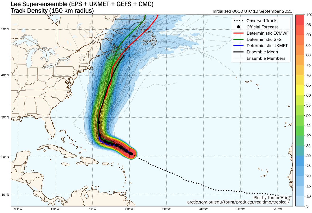
Yesterday's insane 12Z EC run has regained its sanity overnight. That was a result of moving the storm too slowly over the next few days. Only about 6 of 125 ensemble members have the center touching the NE U.S. Coast. I'll point out that this is not a situation like Rita, where we were trying to predict when the center would recurve. That's always hard. In this case, it's very clear that Lee will recurve around 68W as it runs up against a strong SSW-NNE jet core. The jet core will be strengthening by Wed/Thu as Lee turns north. With offshore flow aloft all along the East U.S. Coast, it will be hard for Lee's center to reach the U.S. Looks like a Nova Scotia storm. We have TS winds going out to 345 miles east of the center as it passes well east of Cape Cod Saturday night. Not as far to the west, but Cape Cod may see TS wind as it passes.
5 likes
Re: ATL: LEE - Models
Those multi model plots have a weakness when there's multiple storms going on. I get the timing of the turn, and the jet but lack of anything on Margot or 97L makes me doubt it more than usual. I will say Lee's current position (but not strength) is spot on from Wednesday's NHC forecast.
0 likes
-
ScottNAtlanta

- Category 5

- Posts: 2006
- Joined: Sat May 25, 2013 3:11 pm
- Location: Atlanta, GA
Re: ATL: LEE - Models
I wont believe these models until I see run over run consistency. Four hundred mile shifts every run doesn't make me think they get it yet.
0 likes
The posts in this forum are NOT official forecast and should not be used as such. They are just the opinion of the poster and may or may not be backed by sound meteorological data. They are NOT endorsed by any professional institution or storm2k.org. For official information, please refer to the NHC and NWS products.
-
wxman57
- Moderator-Pro Met
- Posts: 22484
- Age: 66
- Joined: Sat Jun 21, 2003 8:06 pm
- Location: Houston, TX (southwest)
Re: ATL: LEE - Models
ScottNAtlanta wrote:I wont believe these models until I see run over run consistency. Four hundred mile shifts every run doesn't make me think they get it yet.
Run to run consistency is very good. Rarely see it this good. Occasionally, the odd model (EC) has a funky track, but consensus has not changed much in days. Threat of an East U.S. Coast landfall remains minimal, if that. Big waves will impact the coast, though. Cape Cod will possibly see northerly wind near 40 mph Saturday due to Lee's expanded wind field.
4 likes
-
MEANINGLESS_NUMBERS
- Tropical Depression

- Posts: 61
- Joined: Mon Nov 02, 2020 1:43 pm
Re: ATL: LEE - Models
ScottNAtlanta wrote:I wont believe these models until I see run over run consistency. Four hundred mile shifts every run doesn't make me think they get it yet.
The ensembles have been incredibly consistent. If you are only looking at the deterministic models then you are using the technology incorrectly.
0 likes
-
dukeblue219
- S2K Supporter

- Posts: 494
- Joined: Fri Sep 30, 2016 3:52 pm
Re: ATL: LEE - Models
MEANINGLESS_NUMBERS wrote:ScottNAtlanta wrote:I wont believe these models until I see run over run consistency. Four hundred mile shifts every run doesn't make me think they get it yet.
The ensembles have been incredibly consistent. If you are only looking at the deterministic models then you are using the technology incorrectly.
That, and 400 mile shifts on days 7-10 are pretty accurate compared to the not-so-distant past.
0 likes
-
cheezyWXguy

- Category 5
- Posts: 5556
- Joined: Mon Feb 13, 2006 12:29 am
- Location: Dallas, TX
Re: ATL: LEE - Models
dukeblue219 wrote:MEANINGLESS_NUMBERS wrote:ScottNAtlanta wrote:I wont believe these models until I see run over run consistency. Four hundred mile shifts every run doesn't make me think they get it yet.
The ensembles have been incredibly consistent. If you are only looking at the deterministic models then you are using the technology incorrectly.
That, and 400 mile shifts on days 7-10 are pretty accurate compared to the not-so-distant past.
Yeah the setup doesn’t look as uncertain as it did a few days ago. I don’t see any more runs trying to turn the east coast trough negative or have Margot significantly interact with Lee.
1 likes
-
SconnieCane
- Category 4

- Posts: 913
- Joined: Thu Aug 02, 2018 5:29 pm
- Location: Madison, WI
Re: ATL: LEE - Models
New advisory has the forecast secondary peak down to 115kt. So much for that advisory from Friday morning that had Lee never dropping below 130kt through 06Z Tuesday 9/12. Not only the hurricane models but the multiple deterministic EURO runs and sub-910MB EPS members had my expectations sky-high for this one. 
0 likes


Re: ATL: LEE - Models
wxman57 wrote:ScottNAtlanta wrote:I wont believe these models until I see run over run consistency. Four hundred mile shifts every run doesn't make me think they get it yet.
Run to run consistency is very good. Rarely see it this good. Occasionally, the odd model (EC) has a funky track, but consensus has not changed much in days. Threat of an East U.S. Coast landfall remains minimal, if that. Big waves will impact the coast, though. Cape Cod will possibly see northerly wind near 40 mph Saturday due to Lee's expanded wind field.
This has been my observation with Lee as well for like the past several days. I've been astounded how consistent the GFS and ECM models have been run after run essentially arriving at the same solution with only slight variations in the details of Canadian Maritime landfalling or recurvature just offshore. For 8-10-days-out solutions run after run, I can't remember a major system with this level of consistency.
0 likes
-
Kazmit

- Category 5
- Posts: 1915
- Age: 21
- Joined: Mon Jul 25, 2016 8:49 am
- Location: Williamsburg VA for college, Bermuda otherwise
Re: ATL: LEE - Models
SconnieCane wrote:New advisory has the forecast secondary peak down to 115kt. So much for that advisory from Friday morning that had Lee never dropping below 130kt through 06Z Tuesday 9/12. Not only the hurricane models but the multiple deterministic EURO runs and sub-910MB EPS members had my expectations sky-high for this one.
A lot of work still to be done for improving intensity models.
1 likes
Igor 2010, Sandy 2012, Fay 2014, Gonzalo 2014, Joaquin 2015, Nicole 2016, Humberto 2019
I am only a tropical weather enthusiast. My predictions are not official and may or may not be backed by sound meteorological data. For official information, please refer to the NHC and NWS products.
I am only a tropical weather enthusiast. My predictions are not official and may or may not be backed by sound meteorological data. For official information, please refer to the NHC and NWS products.
Re: ATL: LEE - Models
mitchell wrote:wxman57 wrote:ScottNAtlanta wrote:I wont believe these models until I see run over run consistency. Four hundred mile shifts every run doesn't make me think they get it yet.
Run to run consistency is very good. Rarely see it this good. Occasionally, the odd model (EC) has a funky track, but consensus has not changed much in days. Threat of an East U.S. Coast landfall remains minimal, if that. Big waves will impact the coast, though. Cape Cod will possibly see northerly wind near 40 mph Saturday due to Lee's expanded wind field.
This has been my observation with Lee as well for like the past several days. I've been astounded how consistent the GFS and ECM models have been run after run essentially arriving at the same solution with only slight variations in the details of Canadian Maritime landfalling or recurvature just offshore. For 8-10-days-out solutions run after run, I can't remember a major system with this level of consistency.
Yes, I am grateful for consistency in track. They still have work to do to get these fluctuations in intensity locked down. Like there are still too many misunderstood factors that come into play.
0 likes
Cleo - 1964, Betsy - 1965, David - 1979, Andrew - 1992, Charlie (Francis, Ivan, Jeanne) - 2004, Irma - 2017, Ian - 2022
Re: ATL: LEE - Models
wxman57 wrote:ScottNAtlanta wrote:I wont believe these models until I see run over run consistency. Four hundred mile shifts every run doesn't make me think they get it yet.
Run to run consistency is very good. Rarely see it this good. Occasionally, the odd model (EC) has a funky track, but consensus has not changed much in days. Threat of an East U.S. Coast landfall remains minimal, if that. Big waves will impact the coast, though. Cape Cod will possibly see northerly wind near 40 mph Saturday due to Lee's expanded wind field.
This has been my observation with Lee as well for like the past 5 days. I've been astounded how consistent the GFS and ECM models have been run after run essentially arriving at the same solution with only slight variations in the details of Canadian Maritime landfalling or recurvature just offshore. For 8-10-days-out solutions run after run, I can't remember a major system with this level of consistent model solution.
Here are the 8 consecutive GFS model runs (all showing solutions that are a week away) showing location of closest approach to Bermuda.

0 likes
-
USTropics
- Category 5
- Posts: 2420
- Joined: Sun Aug 12, 2007 3:45 am
- Location: Florida State University
Re: ATL: LEE - Models
Kazmit wrote:SconnieCane wrote:New advisory has the forecast secondary peak down to 115kt. So much for that advisory from Friday morning that had Lee never dropping below 130kt through 06Z Tuesday 9/12. Not only the hurricane models but the multiple deterministic EURO runs and sub-910MB EPS members had my expectations sky-high for this one.
A lot of work still to be done for improving intensity models.
Track forecasts will always be easier (the equations and modeling for synoptic level features/patterns is relatively good + level of data coverage is decent). However, modeling meso-level features (like the inner mechanisms/evolution of a tropical cyclone or small features that cause adverse conditions) is much more difficult, and the spatial resolution of global models will never allow them to do this. Discounting the exponential level of entropy in mesoscale, the level of spatial data is just not there either. Meso or regional models like the HWRF, HMON, HAFS, etc. generally do a better job of intensity over global models (their inherent design after all is to model meso features > synoptic features), but they have a long ways to go.
4 likes

Re: ATL: LEE - Models
SconnieCane wrote:New advisory has the forecast secondary peak down to 115kt. So much for that advisory from Friday morning that had Lee never dropping below 130kt through 06Z Tuesday 9/12. Not only the hurricane models but the multiple deterministic EURO runs and sub-910MB EPS members had my expectations sky-high for this one.
Basically every model busted with the increase in shear/displaced ULAC. Lee is going to be a very interesting case study in model output accuracy. The strong consensus for RI into a Cat 4-5 verified, but no model expected the shear.
3 likes
Irene '11 Sandy '12 Hermine '16 5/15/2018 Derecho Fay '20 Isaias '20 Elsa '21 Henri '21 Ida '21
I am only a meteorology enthusiast who knows a decent amount about tropical cyclones. Look to the professional mets, the NHC, or your local weather office for the best information.
I am only a meteorology enthusiast who knows a decent amount about tropical cyclones. Look to the professional mets, the NHC, or your local weather office for the best information.
-
MEANINGLESS_NUMBERS
- Tropical Depression
- Posts: 61
- Joined: Mon Nov 02, 2020 1:43 pm
Re: ATL: LEE - Models
aspen wrote:SconnieCane wrote:New advisory has the forecast secondary peak down to 115kt. So much for that advisory from Friday morning that had Lee never dropping below 130kt through 06Z Tuesday 9/12. Not only the hurricane models but the multiple deterministic EURO runs and sub-910MB EPS members had my expectations sky-high for this one.
Basically every model busted with the increase in shear/displaced ULAC. Lee is going to be a very interesting case study in model output accuracy. The strong consensus for RI into a Cat 4-5 verified, but no model expected the shear.
At some point it is a data limitation though. No model will be accurate if it is not fed accurate, precise, high-resolution data.
2 likes

Re: ATL: LEE - Models
Furthest west GFS run yet, need to wait and see if it's an outlier from the GEFS ensembles like the Euro yesterday. ICON also further west this cycle FWIW.

0 likes
Re: ATL: LEE - Models
Another left/west shift by the 12z GFS, also even slower than the last run. Struggling around 150 hours out, but based on the euro's 12 yesterday timing seems to be everything. Slower it gets the more west it seems to get. 12Z Icon has a cape cod landfall, which is a good left shift from the west end of Nova Scotia at 0z. Canadian shifted left also, from Central Nova Scotia to western Nova Scotia.

Last edited by BobHarlem on Sun Sep 10, 2023 11:24 am, edited 5 times in total.
1 likes
-
hohnywx
- Category 2

- Posts: 504
- Age: 33
- Joined: Sun Jul 19, 2009 8:34 pm
- Location: Hastings-on-Hudson, NY
Re: ATL: LEE - Models
For all those people once again writing off Lee and potential CONUS impacts, the 12z GFS would like to have a word:
0 likes
-
hohnywx
- Category 2
- Posts: 504
- Age: 33
- Joined: Sun Jul 19, 2009 8:34 pm
- Location: Hastings-on-Hudson, NY
Re: ATL: LEE - Models
0 likes
-
hohnywx
- Category 2
- Posts: 504
- Age: 33
- Joined: Sun Jul 19, 2009 8:34 pm
- Location: Hastings-on-Hudson, NY
Re: ATL: LEE - Models
12z CMC remains east of Cape Cod, but has shifted westward since 0z. Would brings impacts to downeast Maine.
0 likes
Who is online
Users browsing this forum: No registered users and 19 guests