ATL: IDALIA - Models

Moderator: S2k Moderators

Message
Author
cane5
Tropical Storm
Tropical Storm
Posts: 249
Joined: Fri Jul 02, 2021 4:24 pm

Re: ATL: IDALIA - Models

#841 Postby cane5 » Tue Aug 29, 2023 12:49 am

Coolcruiseman wrote:


Being on the Space Coast um yeah no thank you. No loopback needed.
FLLurker32 wrote:
ElectricStorm wrote:0z hurricane models:
HAFS-A with a 130kt Cat 4 at landfall (I think this is a bit too strong)
HAFS-B with a 110-115kt Cat 3/4
HMON with around a 115kt Cat 4
HWRF the weakest with a strong Cat 2 just before landfall. 943mb at landfall which would be very low for a Cat 2

Notably all keep it right on or West of 85W until somewhere near or past 27N. Going to have to watch how it steers during RI.


Some models have Idalia doing a uturn coming back and hitting South Florida.
1 likes   

LandoWill
Tropical Depression
Tropical Depression
Posts: 76
Joined: Sun Sep 25, 2022 10:25 pm

Re: ATL: IDALIA - Models

#842 Postby LandoWill » Tue Aug 29, 2023 12:59 am

FLLurker32 wrote:
ElectricStorm wrote:0z hurricane models:
HAFS-A with a 130kt Cat 4 at landfall (I think this is a bit too strong)
HAFS-B with a 110-115kt Cat 3/4
HMON with around a 115kt Cat 4
HWRF the weakest with a strong Cat 2 just before landfall. 943mb at landfall which would be very low for a Cat 2

Notably all keep it right on or West of 85W until somewhere near or past 27N. Going to have to watch how it steers during RI.

RADAR FIX EYE 22.25N 84.84W LIMITED RADAR PRESENTATION DIAM 16NM OPEN SOUTHEAST TO NORTHWEST
1 likes   

User avatar
Bocadude85
Category 5
Category 5
Posts: 2941
Age: 37
Joined: Mon Apr 18, 2005 2:20 pm
Location: Honolulu,Hi

Re: ATL: IDALIA - Models

#843 Postby Bocadude85 » Tue Aug 29, 2023 1:25 am

The 0z Euro-Fast looks east of 18z and 12z, but it’s difficult to tell by how much.
Edit now that the 0z Euro is coming in, it in fact is a very minor shift.
Last edited by Bocadude85 on Tue Aug 29, 2023 2:00 am, edited 1 time in total.
1 likes   

FLLurker32
Tropical Storm
Tropical Storm
Posts: 140
Joined: Mon Aug 29, 2016 10:31 am

Re: ATL: IDALIA - Models

#844 Postby FLLurker32 » Tue Aug 29, 2023 1:28 am

Bocadude85 wrote:The 0z Euro-Fast looks east of 18z and 12z, but its difficult to tell by how much

Looks maybe 20 miles north of cedar key.
1 likes   

caneman
Category 5
Category 5
Posts: 1178
Joined: Fri Sep 05, 2014 5:44 am
Location: Clearwater Beach, Fl

Re: ATL: IDALIA - Models

#845 Postby caneman » Tue Aug 29, 2023 1:30 am

FLLurker32 wrote:
Bocadude85 wrote:The 0z Euro-Fast looks east of 18z and 12z, but its difficult to tell by how much

Looks maybe 20 miles north of cedar key.


Agree. That's a good bump east. Are we sure that is current? How does that differ from the regular Euro? Is it accurate?
0 likes   

User avatar
Bocadude85
Category 5
Category 5
Posts: 2941
Age: 37
Joined: Mon Apr 18, 2005 2:20 pm
Location: Honolulu,Hi

Re: ATL: IDALIA - Models

#846 Postby Bocadude85 » Tue Aug 29, 2023 1:36 am

caneman wrote:
FLLurker32 wrote:
Bocadude85 wrote:The 0z Euro-Fast looks east of 18z and 12z, but its difficult to tell by how much

Looks maybe 20 miles north of cedar key.


Agree. That's a good bump east. Are we sure that is current? How does that differ from the regular Euro? Is it accurate?


It is the same as the Euro afaik, it just comes out faster since it is released in 24 hour increments
1 likes   

FLLurker32
Tropical Storm
Tropical Storm
Posts: 140
Joined: Mon Aug 29, 2016 10:31 am

Re: ATL: IDALIA - Models

#847 Postby FLLurker32 » Tue Aug 29, 2023 1:43 am

Bocadude85 wrote:
caneman wrote:
FLLurker32 wrote:Looks maybe 20 miles north of cedar key.


Agree. That's a good bump east. Are we sure that is current? How does that differ from the regular Euro? Is it accurate?


It is the same as the Euro afaik, it just comes out faster since it is released in 24 hour increments

It is the same. It’s a very slight shift East from last run. Nothing crazy.
1 likes   

caneman
Category 5
Category 5
Posts: 1178
Joined: Fri Sep 05, 2014 5:44 am
Location: Clearwater Beach, Fl

Re: ATL: IDALIA - Models

#848 Postby caneman » Tue Aug 29, 2023 1:47 am

FLLurker32 wrote:
Bocadude85 wrote:
caneman wrote:
Agree. That's a good bump east. Are we sure that is current? How does that differ from the regular Euro? Is it accurate?


It is the same as the Euro afaik, it just comes out faster since it is released in 24 hour increments

It is the same. It’s a very slight shift East from last run. Nothing crazy.


Every little shift can matter living here on the beaches of Pinellas. What are you alls thoughts on the RBM Graf model on the prior page. Has it had any success in short term hurricane modeling?
0 likes   

Keldeo1997
Category 2
Category 2
Posts: 514
Joined: Fri Oct 11, 2019 11:35 pm

Re: ATL: IDALIA - Models

#849 Postby Keldeo1997 » Tue Aug 29, 2023 2:55 am

Image

This needs to get more attention. There is a non 0% chance we get round 2
4 likes   

User avatar
Blown Away
S2K Supporter
S2K Supporter
Posts: 9867
Joined: Wed May 26, 2004 6:17 am

Re: ATL: IDALIA - Models

#850 Postby Blown Away » Tue Aug 29, 2023 4:15 am

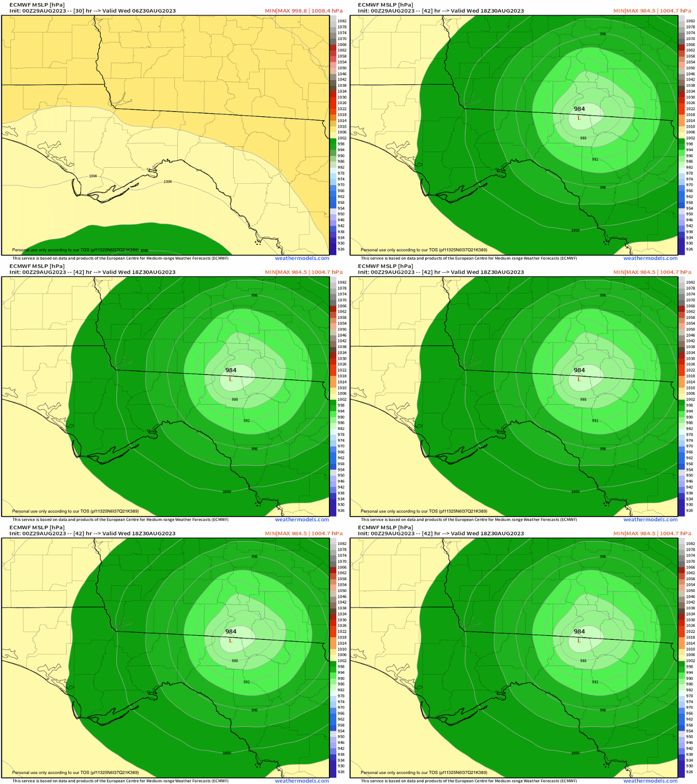
Image
00z Euro… Slightly E
0 likes   
Hurricane Eye Experience: David 79, Irene 99, Frances 04, Jeanne 04, Wilma 05... EYE COMING MY WAY IN 2024…
Hurricane Brush Experience: Andrew 92, Erin 95, Floyd 99, Matthew 16, Irma 17, Ian 22, Nicole 22…

User avatar
CFLHurricane
Category 1
Category 1
Posts: 312
Joined: Thu Mar 27, 2014 5:56 pm
Location: Floriduh

Re: ATL: IDALIA - Models

#851 Postby CFLHurricane » Tue Aug 29, 2023 4:18 am

Keldeo1997 wrote:https://pbs.twimg.com/media/F4rr0w0bcAArbht?format=png&name=900x900

This needs to get more attention. There is a non 0% chance we get round 2


Looks like more attention will be payed to it in about 72 hours. NGL, the possibility is intriguing.
1 likes   
I'm not a meteorologist, but I did stay at a motel 8.

User avatar
NDG
S2K Supporter
S2K Supporter
Posts: 14933
Joined: Sun Jul 09, 2006 10:14 pm
Location: Orlando, FL

Re: ATL: IDALIA - Models

#852 Postby NDG » Tue Aug 29, 2023 5:02 am

06z GFS fairly similar to its earlier 0z run, has it tracking almost straight north for the next 24 hrs.

Image
0 likes   

Michele B
Category 4
Category 4
Posts: 906
Joined: Thu Aug 25, 2016 8:08 am
Location: SWFL

Re: ATL: IDALIA - Models

#853 Postby Michele B » Tue Aug 29, 2023 5:56 am

CFLHurricane wrote:
Keldeo1997 wrote:https://pbs.twimg.com/media/F4rr0w0bcAArbht?format=png&name=900x900

This needs to get more attention. There is a non 0% chance we get round 2


Looks like more attention will be payed to it in about 72 hours. NGL, the possibility is intriguing.


Intriguing?!?!?

That’s as crazy as it gets.
0 likes   
Cleo - 1964, Betsy - 1965, David - 1979, Andrew - 1992, Charlie (Francis, Ivan, Jeanne) - 2004, Irma - 2017, Ian - 2022

HurricaneFrances04
Category 2
Category 2
Posts: 595
Joined: Mon Jun 25, 2012 8:09 am
Location: Fort Lauderdale, Florida

Re: ATL: IDALIA - Models

#854 Postby HurricaneFrances04 » Tue Aug 29, 2023 6:33 am

The giant loop shown in the GFS reminds me of Ivan in 2004. Its remnants also looped around and tracked over southern Florida before redeveloping in the Gulf and striking Louisiana/Texas as a weak tropical storm
2 likes   

User avatar
chris_fit
Category 5
Category 5
Posts: 3078
Joined: Wed Sep 10, 2003 11:58 pm
Location: Tampa Bay Area, FL
Contact:

Re: ATL: IDALIA - Models

#855 Postby chris_fit » Tue Aug 29, 2023 6:57 am

06z EURO

Image
2 likes   

User avatar
chris_fit
Category 5
Category 5
Posts: 3078
Joined: Wed Sep 10, 2003 11:58 pm
Location: Tampa Bay Area, FL
Contact:

Re: ATL: IDALIA - Models

#856 Postby chris_fit » Tue Aug 29, 2023 7:05 am

FWIW - tracking E of almost all guidance and official NHC Track. I'm sure it's just a wobble... but always get that uneasy feeling when it wobbles in the 'wrong' direction.


Image
5 likes   

User avatar
chris_fit
Category 5
Category 5
Posts: 3078
Joined: Wed Sep 10, 2003 11:58 pm
Location: Tampa Bay Area, FL
Contact:

Re: ATL: IDALIA - Models

#857 Postby chris_fit » Tue Aug 29, 2023 7:07 am

I would like to note that the NNW/NW movement that many of the models were showing yesterday did not seem to materialize.
4 likes   

fllawyer
Tropical Low
Tropical Low
Posts: 45
Joined: Wed Aug 28, 2019 11:45 am

Re: ATL: IDALIA - Models

#858 Postby fllawyer » Tue Aug 29, 2023 7:22 am

chris_fit wrote:06z EURO

https://i.imgur.com/3ENgg2a.png


Seems this verifies if storm keeps almost due N track until landfall. Or of course goes E and then wobbles back W.
0 likes   

sarcean
Tropical Wave
Tropical Wave
Posts: 5
Joined: Wed Sep 12, 2018 6:09 pm

Re: ATL: IDALIA - Models

#859 Postby sarcean » Tue Aug 29, 2023 7:27 am

HurricaneFrances04 wrote:The giant loop shown in the GFS reminds me of Ivan in 2004. Its remnants also looped around and tracked over southern Florida before redeveloping in the Gulf and striking Louisiana/Texas as a weak tropical storm

Ivan was pretty wild
Image
2 likes   

User avatar
chaser1
S2K Supporter
S2K Supporter
Posts: 4716
Age: 63
Joined: Sat Oct 15, 2005 5:59 pm
Location: Longwood, Fl

Re: ATL: IDALIA - Models

#860 Postby chaser1 » Tue Aug 29, 2023 7:27 am

chris_fit wrote:FWIW - tracking E of almost all guidance and official NHC Track. I'm sure it's just a wobble... but always get that uneasy feeling when it wobbles in the 'wrong' direction.


https://i.imgur.com/QGPBoO9.png


Apparently and hopefully, the current heading would appear to "catch-up" with all of the guidance tracks. Looks to me like its now tracking pretty much close to due north.
2 likes   
Personal Forecast Disclaimer:
The posts in this forum are NOT official forecast and should not be used as such. They are just the opinion of the poster and may or may not be backed by sound meteorological data. They are NOT endorsed by any professional institution or storm2k.org. For official information, please refer to the NHC and NWS products.


Return to “2023”

Who is online

Users browsing this forum: No registered users and 25 guests