
WPAC: BOLAVEN - Post-Tropical
Moderator: S2k Moderators
-
mrbagyo

- Category 5

- Posts: 3615
- Age: 32
- Joined: Thu Apr 12, 2012 9:18 am
- Location: 14.13N 120.98E
- Contact:
Re: WPAC: BOLAVEN - Typhoon
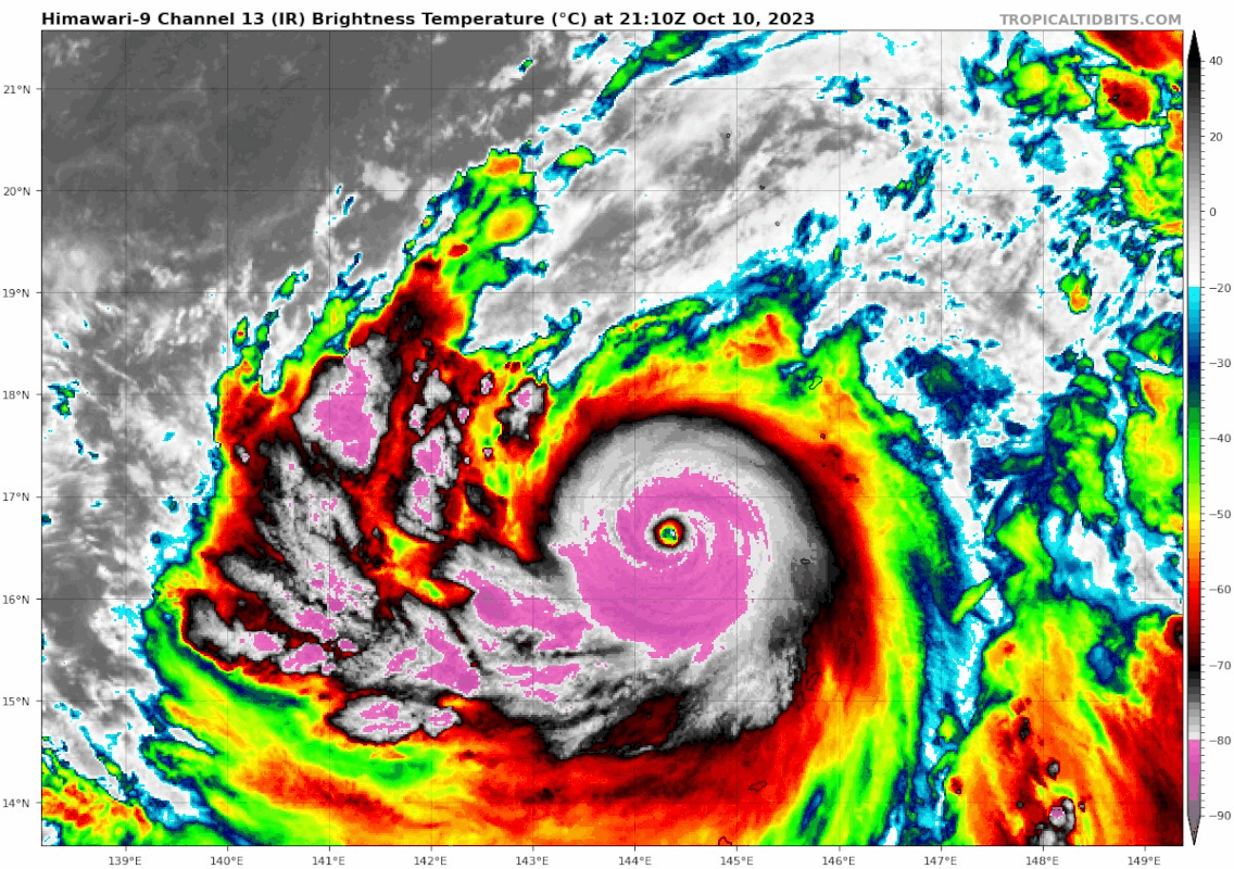
Center Temp : +21.4C Cloud Region Temp : -76.8C
0 likes
The posts in this forum are NOT official forecast and should not be used as such. They are just the opinion of the poster and may or may not be backed by sound meteorological data. They are NOT endorsed by any professional institution or storm2k.org. For official information, please refer to RSMC, NHC and NWS products.
-
mrbagyo
- Category 5
- Posts: 3615
- Age: 32
- Joined: Thu Apr 12, 2012 9:18 am
- Location: 14.13N 120.98E
- Contact:
Re: WPAC: BOLAVEN - Typhoon
2023OCT11 003000 6.2 939.7 119.8 6.2 6.1 7.4 1.3T/6hr OFF OFF OFF OFF 20.42 -78.20 EYE 14 IR 51.6 17.17 -143.95 ARCHER HIM-9 20.4
2023OCT11 010000 6.2 939.7 119.8 6.2 6.0 7.3 1.3T/6hr OFF OFF OFF OFF 21.12 -77.55 EYE 15 IR 51.6 17.26 -143.91 ARCHER HIM-9 20.5
2023OCT11 013000 6.2 939.7 119.8 6.1 6.1 7.2 1.3T/6hr ON OFF OFF OFF 21.38 -76.82 EYE 15 IR 51.6 17.33 -143.87 ARCHER HIM-9 20.6
2023OCT11 020000 6.2 939.6 119.8 6.1 6.1 7.3 1.3T/6hr ON OFF OFF OFF 22.72 -77.04 EYE 15 IR 51.6 17.44 -143.83 ARCHER HIM-9 20.7
2023OCT11 022000 6.2 939.6 119.8 6.1 6.1 7.3 1.3T/6hr ON OFF OFF OFF 21.74 -77.41 EYE 15 IR 51.6 17.54 -143.78 ARCHER HIM-9 20.8
0 likes
The posts in this forum are NOT official forecast and should not be used as such. They are just the opinion of the poster and may or may not be backed by sound meteorological data. They are NOT endorsed by any professional institution or storm2k.org. For official information, please refer to RSMC, NHC and NWS products.
-
mrbagyo
- Category 5
- Posts: 3615
- Age: 32
- Joined: Thu Apr 12, 2012 9:18 am
- Location: 14.13N 120.98E
- Contact:
Re: WPAC: BOLAVEN - Typhoon

1 likes
The posts in this forum are NOT official forecast and should not be used as such. They are just the opinion of the poster and may or may not be backed by sound meteorological data. They are NOT endorsed by any professional institution or storm2k.org. For official information, please refer to RSMC, NHC and NWS products.

Re: WPAC: BOLAVEN - Typhoon
StormTracker89 wrote:aspen wrote:Yellow Evan wrote:TPPN11 PGTW 110006
A. TYPHOON 15W (BOLAVEN)
B. 10/2330Z
C. 16.98N
D. 144.13E
E. ONE/GK2A
F. T6.5/6.5/D2.0/24HRS STT: S0.0/03HRS
G. IR/EIR/VIS/MSI
H. REMARKS: 03A/PBO EYE/ANMTN. OW EYE SURROUNDED BY CMG YIELDS AN E#
OF 6.5. MET YIELDS 6.0. PT YIELDS 6.5. DBO DT.
I. ADDITIONAL POSITIONS:
10/2044Z 16.33N 144.40E SSMS
RAE
No.
https://media.discordapp.net/attachments/619419338151034911/1161457988494700654/IMG_1856.gif?ex=65385f0b&is=6525ea0b&hm=8626bd803c513db66ef267618e39483c66e02be7b6502a70c63e545039f03b9c&
How much you wanna bet this is never operationally classified as a Cat 5?
I'll bet you a lot!
You lost lol
0 likes
-
doomhaMwx

- Category 5
- Posts: 2398
- Age: 25
- Joined: Tue Apr 18, 2017 4:01 am
- Location: Baguio/Benguet, Philippines
- Contact:
Re: WPAC: BOLAVEN - Typhoon
Eye temp from polar-orbiting satellites is already as high as 25-26C.
https://twitter.com/zeb199818/status/1711964631319859367
https://twitter.com/CyanideCN_/status/1711926035078578529
https://twitter.com/zeb199818/status/1711964631319859367
https://twitter.com/CyanideCN_/status/1711926035078578529
0 likes
Like my content? Consider giving a tip.
-
1900hurricane

- Category 5
- Posts: 6044
- Age: 33
- Joined: Fri Feb 06, 2015 12:04 pm
- Location: Houston, TX
- Contact:
Re: WPAC: BOLAVEN - Typhoon
I dig it.
0 likes
Contract Meteorologist. TAMU & MSST. Fiercely authentic, one of a kind. We are all given free will, so choose a life meant to be lived. We are the Masters of our own Stories.
Opinions expressed are mine alone.
Follow me on Twitter at @1900hurricane : Read blogs at https://1900hurricane.wordpress.com/
Opinions expressed are mine alone.
Follow me on Twitter at @1900hurricane : Read blogs at https://1900hurricane.wordpress.com/
-
doomhaMwx
- Category 5
- Posts: 2398
- Age: 25
- Joined: Tue Apr 18, 2017 4:01 am
- Location: Baguio/Benguet, Philippines
- Contact:
Re: WPAC: BOLAVEN - Typhoon
Looks like the beginnings of a secondary eyewall on the latest MW scan.


0 likes
Like my content? Consider giving a tip.
-
ElectricStorm

- Category 5
- Posts: 4597
- Age: 23
- Joined: Tue Aug 13, 2019 11:23 pm
- Location: Skiatook, OK / Norman, OK
Re: WPAC: BOLAVEN - Typhoon
15W BOLAVEN 231011 0600 18.2N 143.4E WPAC 145 915
I think this is a bit too low. I'd probably go 150-155kts
0 likes
I am in no way a professional. Take what I say with a grain of salt as I could be totally wrong. Please refer to the NHC, NWS, or SPC for official information.
Boomer Sooner!
Boomer Sooner!
-
doomhaMwx
- Category 5
- Posts: 2398
- Age: 25
- Joined: Tue Apr 18, 2017 4:01 am
- Location: Baguio/Benguet, Philippines
- Contact:
Re: WPAC: BOLAVEN - Typhoon
T2315(Bolaven)
Issued at 2023/10/11 06:50 UTC
Analysis at 10/11 06 UTC
Grade TY
Scale Large
Intensity Violent
Center position N18°05′ (18.1°)
E143°25′ (143.4°)
Direction and speed of movement NNW 20 km/h (12 kt)
Central pressure 915 hPa
Maximum sustained wind speed near center 55 m/s (105 kt)
Maximum wind gust speed 75 m/s (150 kt)
Radius of 50-kt wind area 110 km (60 NM)
Radius of 30-kt wind area 560 km (300 NM)
Forecast for 10/11 18 UTC
Grade TY
Intensity Violent
Center position of probability circle N19°50′ (19.8°)
E142°55′ (142.9°)
Direction and speed of movement NNW 15 km/h (9 kt)
Central pressure 905 hPa
Maximum sustained wind speed near center 55 m/s (110 kt)
Maximum wind gust speed 80 m/s (155 kt)
Radius of probability circle 65 km (35 NM)
Radius of storm warning area 210 km (115 NM)
0 likes
Like my content? Consider giving a tip.

Re: WPAC: BOLAVEN - Typhoon
ElectricStorm wrote:15W BOLAVEN 231011 0600 18.2N 143.4E WPAC 145 915
I think this is a bit too low. I'd probably go 150-155kts
Maybe by 12z if the eye retains at near or equal 20C+ or if CI is at 7.5
2023OCT11 070000 7.2 914.0 146.0 7.2 7.4 7.5 2.7T/12hr OFF OFF OFF OFF 19.92 -78.50 EYE 15 IR 83.5 18.23 -143.30 ARCHER HIM-9 21.5
0 likes
ヤンデレ女が寝取られるているのを見たい!!!
ECMWF ensemble NWPAC plots: https://ecmwfensnwpac.imgbb.com/
Multimodel NWPAC plots: https://multimodelnwpac.imgbb.com/
GFS Ensemble NWPAC plots (16 & 35 day forecast): https://gefsnwpac.imgbb.com/
Plots updated automatically
ECMWF ensemble NWPAC plots: https://ecmwfensnwpac.imgbb.com/
Multimodel NWPAC plots: https://multimodelnwpac.imgbb.com/
GFS Ensemble NWPAC plots (16 & 35 day forecast): https://gefsnwpac.imgbb.com/
Plots updated automatically
-
doomhaMwx
- Category 5
- Posts: 2398
- Age: 25
- Joined: Tue Apr 18, 2017 4:01 am
- Location: Baguio/Benguet, Philippines
- Contact:
Re: WPAC: BOLAVEN - Typhoon
A moat is becoming more pronounced around the eyewall, and CIMSS M-PERC product indicates that an EWRC is highly likely to commence soon.
Assuming an EWRC goes smoothly, Bolaven can still easily re-intensify given that it has yet to experience the most favorable upper-level environment in its life (improving poleward outflow in the next 24 hours).

Assuming an EWRC goes smoothly, Bolaven can still easily re-intensify given that it has yet to experience the most favorable upper-level environment in its life (improving poleward outflow in the next 24 hours).
0 likes
Like my content? Consider giving a tip.
-
doomhaMwx
- Category 5
- Posts: 2398
- Age: 25
- Joined: Tue Apr 18, 2017 4:01 am
- Location: Baguio/Benguet, Philippines
- Contact:
Re: WPAC: BOLAVEN - Typhoon
T7.5 from JTWC
TPPN10 PGTW 110908
A. SUPER TYPHOON 15W (BOLAVEN)
B. 11/0840Z
C. 18.45N
D. 143.16E
E. ONE/GK2A
F. T7.5/7.5/D3.0/24HRS STT: D0.5/03HRS
G. IR/EIR
H. REMARKS: 01A/PBO EYE/ANMTN. WMG EYE SURROUNDED BY CMG YIELDS AN
E# OF 6.5. ADDED 1.0 EYE ADJUSTMENT FOR CMG, TO YIELD A DT OF 7.5.
MET YIELDS 6.0. PT IS CONSTRAINED TO 7.0. DBO DT, AS THE CMG CANOPY
HAS PERSISTED OVER 6 HOURS, JUSTIFYING BREAKING 2.5 T NUMBER CHANGE
IN 24HR CONSTRAINT.
I. ADDITIONAL POSITIONS:
11/0414Z 17.53N 145.07E AMS2
11/0414Z 18.02N 143.55E AMS2
11/0414Z 18.02N 143.55E AMS2
11/0414Z 18.02N 143.55E AMS2
CVACH
0 likes
Like my content? Consider giving a tip.
Re: WPAC: BOLAVEN - Typhoon
Nice ADT value 

0 likes
ヤンデレ女が寝取られるているのを見たい!!!
ECMWF ensemble NWPAC plots: https://ecmwfensnwpac.imgbb.com/
Multimodel NWPAC plots: https://multimodelnwpac.imgbb.com/
GFS Ensemble NWPAC plots (16 & 35 day forecast): https://gefsnwpac.imgbb.com/
Plots updated automatically
ECMWF ensemble NWPAC plots: https://ecmwfensnwpac.imgbb.com/
Multimodel NWPAC plots: https://multimodelnwpac.imgbb.com/
GFS Ensemble NWPAC plots (16 & 35 day forecast): https://gefsnwpac.imgbb.com/
Plots updated automatically
Re: WPAC: BOLAVEN - Typhoon
D-PRINT 162 kts

0 likes
ヤンデレ女が寝取られるているのを見たい!!!
ECMWF ensemble NWPAC plots: https://ecmwfensnwpac.imgbb.com/
Multimodel NWPAC plots: https://multimodelnwpac.imgbb.com/
GFS Ensemble NWPAC plots (16 & 35 day forecast): https://gefsnwpac.imgbb.com/
Plots updated automatically
ECMWF ensemble NWPAC plots: https://ecmwfensnwpac.imgbb.com/
Multimodel NWPAC plots: https://multimodelnwpac.imgbb.com/
GFS Ensemble NWPAC plots (16 & 35 day forecast): https://gefsnwpac.imgbb.com/
Plots updated automatically
Re: WPAC: BOLAVEN - Typhoon
JMA 09Z upgrades to 905 mb, new peak forecast 900 mb, also 2023's Bolaven is now officially stronger than 2012's Bolaven (910 mb) (actually it already did at 06z in terms of winds)
T2315(Bolaven)
Issued at 2023/10/11 09:45 UTC
Analysis at 10/11 09 UTC
Grade TY
Scale Large
Intensity Violent
Center position N18°30′ (18.5°)
E143°10′ (143.2°)
Direction and speed of movement NNW 20 km/h (11 kt)
Central pressure 905 hPa
Maximum sustained wind speed near center 55 m/s (110 kt)
Maximum wind gust speed 80 m/s (155 kt)
Radius of 50-kt wind area 110 km (60 NM)
Radius of 30-kt wind area 560 km (300 NM)
Forecast for 10/11 21 UTC
Grade TY
Intensity Violent
Center position of probability circle N20°10′ (20.2°)
E143°00′ (143.0°)
Direction and speed of movement N 15 km/h (9 kt)
Central pressure 900 hPa
Maximum sustained wind speed near center 60 m/s (115 kt)
Maximum wind gust speed 85 m/s (165 kt)
Radius of probability circle 65 km (35 NM)
Radius of storm warning area 210 km (115 NM)
0 likes
ヤンデレ女が寝取られるているのを見たい!!!
ECMWF ensemble NWPAC plots: https://ecmwfensnwpac.imgbb.com/
Multimodel NWPAC plots: https://multimodelnwpac.imgbb.com/
GFS Ensemble NWPAC plots (16 & 35 day forecast): https://gefsnwpac.imgbb.com/
Plots updated automatically
ECMWF ensemble NWPAC plots: https://ecmwfensnwpac.imgbb.com/
Multimodel NWPAC plots: https://multimodelnwpac.imgbb.com/
GFS Ensemble NWPAC plots (16 & 35 day forecast): https://gefsnwpac.imgbb.com/
Plots updated automatically
-
mrbagyo
- Category 5
- Posts: 3615
- Age: 32
- Joined: Thu Apr 12, 2012 9:18 am
- Location: 14.13N 120.98E
- Contact:
Re: WPAC: BOLAVEN - Typhoon
JMA now at 905 hpa / 110 knots - projected peak is 900 hPa / 115 knots
CMA already has it at 900 hPa / 68 m/s
I think JTWC would up the intensity to 155 by 12z
CMA already has it at 900 hPa / 68 m/s
I think JTWC would up the intensity to 155 by 12z
0 likes
The posts in this forum are NOT official forecast and should not be used as such. They are just the opinion of the poster and may or may not be backed by sound meteorological data. They are NOT endorsed by any professional institution or storm2k.org. For official information, please refer to RSMC, NHC and NWS products.
-
Yellow Evan

- Professional-Met

- Posts: 15956
- Age: 25
- Joined: Fri Jul 15, 2011 12:48 pm
- Location: Henderson, Nevada/Honolulu, HI
- Contact:
Re: WPAC: BOLAVEN - Typhoon
TPPN11 PGTW 111149
A. SUPER TYPHOON 15W (BOLAVEN)
B. 11/1130Z
C. 18.75N
D. 143.01E
E. ONE/GK2A
F. T7.5/7.5/D3.0/24HRS STT: S0.0/03HRS
G. IR/EIR
H. REMARKS: 01A/PBO EYE/ANMTN. WMG EYE SURROUNDED BY CMG YIELDS AN
E# OF 6.5. ADDED 1.0 EYE ADJUSTMENT FOR CMG, TO YIELD A DT OF 7.5.
MET YIELDS 6.0. PT YIELDS 7.0. DBO DT.
I. ADDITIONAL POSITIONS: NONE
EL-NAZLY
0 likes
-
Yellow Evan
- Professional-Met
- Posts: 15956
- Age: 25
- Joined: Fri Jul 15, 2011 12:48 pm
- Location: Henderson, Nevada/Honolulu, HI
- Contact:
Re: WPAC: BOLAVEN - Typhoon

DPrint probably on the money here maybe a little low. Eye temperature has been over 20C for 9 hours and CDO has expanded outward overnight.
0 likes

Re: WPAC: BOLAVEN - Typhoon
I think this has probably peaked at 160-165 kt, due to how long it’s maintained a >20C eye and CMG ring with spots of CDG. You don’t get a 26C eye from just a run-of-the-mill Cat 5.
0 likes
Irene '11 Sandy '12 Hermine '16 5/15/2018 Derecho Fay '20 Isaias '20 Elsa '21 Henri '21 Ida '21
I am only a meteorology enthusiast who knows a decent amount about tropical cyclones. Look to the professional mets, the NHC, or your local weather office for the best information.
I am only a meteorology enthusiast who knows a decent amount about tropical cyclones. Look to the professional mets, the NHC, or your local weather office for the best information.
Who is online
Users browsing this forum: No registered users and 19 guests