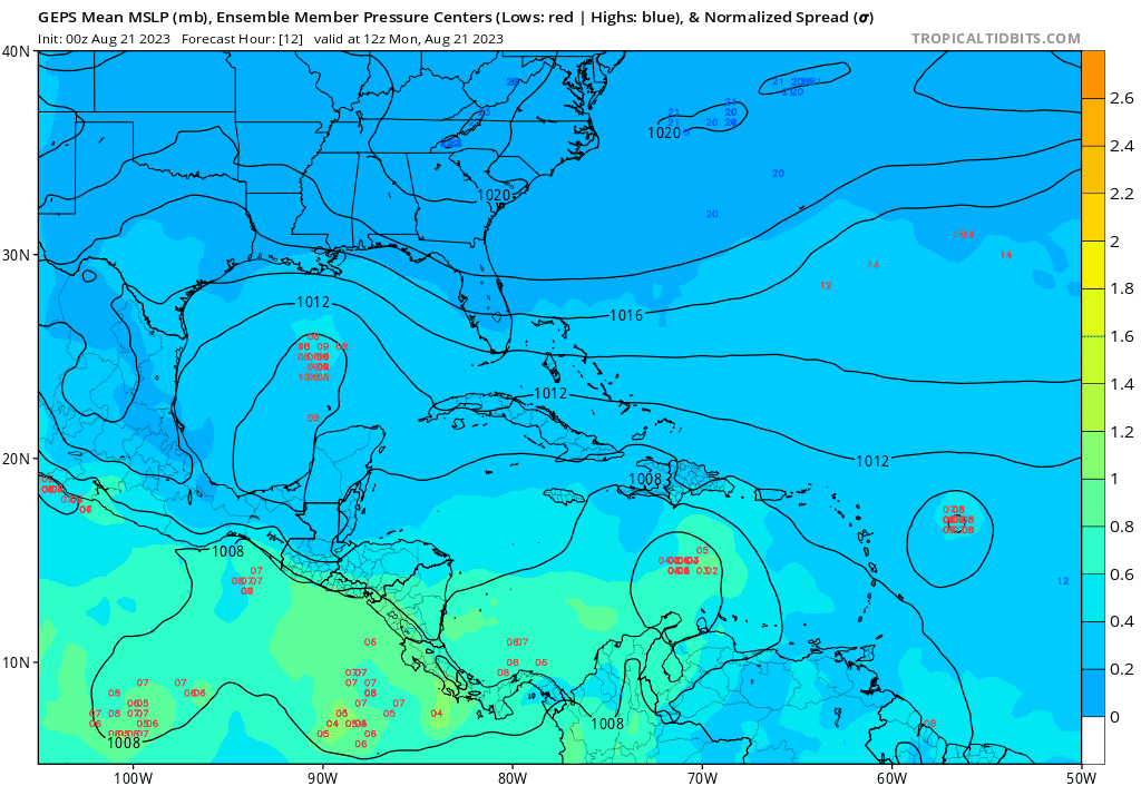
ATL: FRANKLIN - Models

Moderator: S2k Moderators

Message
Author
User avatar
SFLcane
S2K Supporter
S2K Supporter
Posts: 9617
Age: 46
Joined: Sat Jun 05, 2010 1:44 pm
Location: Lake Worth Florida

Re: ATL: FRANKLIN - Models

#61 Postby SFLcane » Mon Aug 21, 2023 11:23 am

jfk08c wrote:
Blown Away wrote:[url]https://i.postimg.cc/NFZPN9Dw/gfs-mslp-wind-watl-fh24-132.gif [/url]

12z GFS… Uh oh, left turn signal on!! :eek:


Giving some Jeanne vibes with that hook back west


Lol that is highly unlikely.
0 likes   

User avatar
jfk08c
S2K Supporter
S2K Supporter
Posts: 151
Joined: Mon Jun 11, 2018 4:36 pm
Location: Lakeland, FL

Re: ATL: FRANKLIN - Models

#62 Postby jfk08c » Mon Aug 21, 2023 11:26 am

SFLcane wrote:
jfk08c wrote:
Blown Away wrote:[url]https://i.postimg.cc/NFZPN9Dw/gfs-mslp-wind-watl-fh24-132.gif [/url]

12z GFS… Uh oh, left turn signal on!! :eek:


Giving some Jeanne vibes with that hook back west


Lol that is highly unlikely.


Ok? Just said that model run reminded me of the loop around west Jeanne did in roughly the same area. Never said it would verify
0 likes   

User avatar
Blown Away
S2K Supporter
S2K Supporter
Posts: 9867
Joined: Wed May 26, 2004 6:17 am

Re: ATL: FRANKLIN - Models

#63 Postby Blown Away » Mon Aug 21, 2023 11:28 am

SFLcane wrote:
jfk08c wrote:
Blown Away wrote:[url]https://i.postimg.cc/NFZPN9Dw/gfs-mslp-wind-watl-fh24-132.gif [/url]

12z GFS… Uh oh, left turn signal on!! :eek:


Giving some Jeanne vibes with that hook back west


GFS all on its own going ENE almost @8 degrees once above Hispaniola… All other models starting to adjust to a climatologically smoother N movement out of the Caribbean.

Also, 2004 is a analog used by Phil.
2 likes   
Hurricane Eye Experience: David 79, Irene 99, Frances 04, Jeanne 04, Wilma 05... EYE COMING MY WAY IN 2024…
Hurricane Brush Experience: Andrew 92, Erin 95, Floyd 99, Matthew 16, Irma 17, Ian 22, Nicole 22…

User avatar
Spacecoast
Category 2
Category 2
Posts: 687
Joined: Thu Aug 31, 2017 2:03 pm

Re: ATL: FRANKLIN - Models

#64 Postby Spacecoast » Mon Aug 21, 2023 11:37 am

TVCN/TVCX/OFCL Consensus tracks usually have lowest track errors...
Image
0 likes   

User avatar
Blown Away
S2K Supporter
S2K Supporter
Posts: 9867
Joined: Wed May 26, 2004 6:17 am

Re: ATL: FRANKLIN - Models

#65 Postby Blown Away » Mon Aug 21, 2023 11:39 am

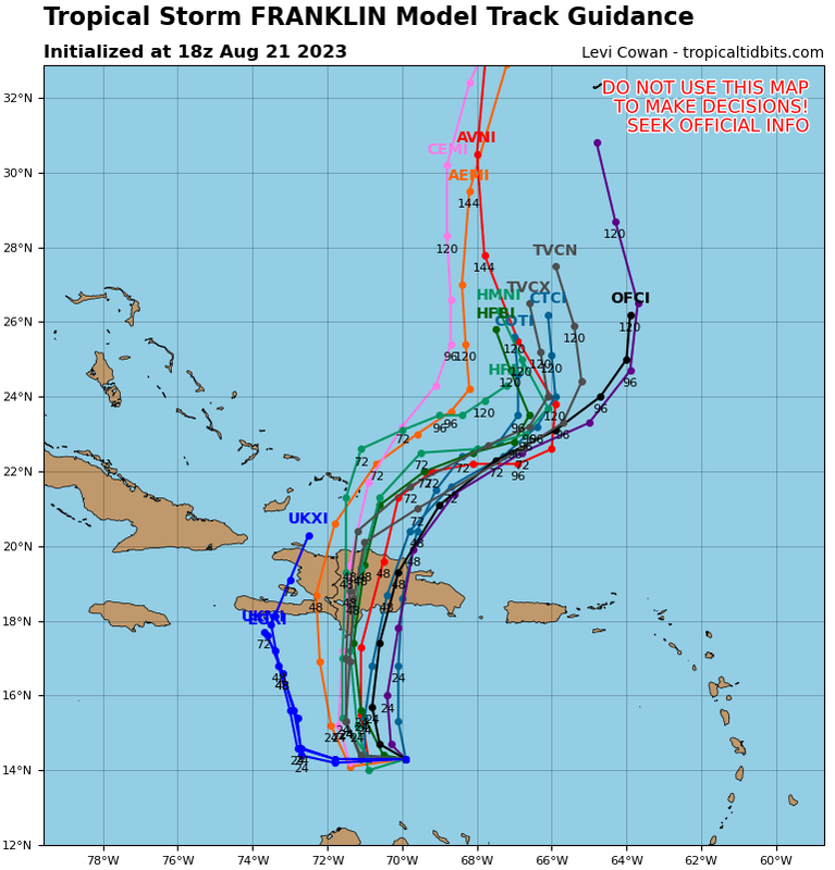
Spacecoast wrote:TVCN/TVCX/OFCL Consensus tracks usually have lowest track errors...
https://i.ibb.co/Bjh6gvf/ef22.jpg


Let’s see this map later today once recent 12z models are imputed.
1 likes   
Hurricane Eye Experience: David 79, Irene 99, Frances 04, Jeanne 04, Wilma 05... EYE COMING MY WAY IN 2024…
Hurricane Brush Experience: Andrew 92, Erin 95, Floyd 99, Matthew 16, Irma 17, Ian 22, Nicole 22…

User avatar
Woofde
Category 1
Category 1
Posts: 278
Joined: Tue Jul 06, 2021 11:33 am

Re: ATL: FRANKLIN - Models

#66 Postby Woofde » Mon Aug 21, 2023 11:50 am

Models usually end up adjusting closer to climatology as time grows nearer. A storm going the west to east over Hispaniola in August is very unusual. Though its not impossible, i would bet more on the models adjusting back west.
3 likes   

User avatar
Blown Away
S2K Supporter
S2K Supporter
Posts: 9867
Joined: Wed May 26, 2004 6:17 am

Re: ATL: FRANKLIN - Models

#67 Postby Blown Away » Mon Aug 21, 2023 12:16 pm

Image

12z GEPS… Now show potential impact to SE Bahamas, SFL, EGOM.
0 likes   
Hurricane Eye Experience: David 79, Irene 99, Frances 04, Jeanne 04, Wilma 05... EYE COMING MY WAY IN 2024…
Hurricane Brush Experience: Andrew 92, Erin 95, Floyd 99, Matthew 16, Irma 17, Ian 22, Nicole 22…

User avatar
Beef Stew
Category 1
Category 1
Posts: 288
Joined: Sat May 30, 2020 11:31 am
Location: South Florida

Re: ATL: FRANKLIN - Models

#68 Postby Beef Stew » Mon Aug 21, 2023 12:30 pm

As currently forecast, it would definitely be an interesting track for this time of year, climatologically speaking. As others have said, continual westward shifts in the modeling, like we’ve seen in the 12z suite, would be more aligned with climo. Although they were October storms, with much different synoptic setups- Hazel, and more recently, Matthew come to mind track-wise for possible analogs should the signal for a more western solution post-Hispaniola grow stronger.
1 likes   

BobHarlem
Category 5
Category 5
Posts: 1665
Joined: Thu Oct 20, 2005 6:11 pm

Re: ATL: FRANKLIN - Models

#69 Postby BobHarlem » Mon Aug 21, 2023 2:38 pm

12z euro stall's Franklin north of the Caribbean like it's not sure quite what to do with it forever before eventually going north.
0 likes   

User avatar
Blown Away
S2K Supporter
S2K Supporter
Posts: 9867
Joined: Wed May 26, 2004 6:17 am

Re: ATL: FRANKLIN - Models

#70 Postby Blown Away » Mon Aug 21, 2023 3:32 pm

BobHarlem wrote:12z euro stall's Franklin north of the Caribbean like it's not sure quite what to do with it forever before eventually going north.

Image

You can see the flow, it’s all about timing coming out of the Caribbean.
0 likes   
Hurricane Eye Experience: David 79, Irene 99, Frances 04, Jeanne 04, Wilma 05... EYE COMING MY WAY IN 2024…
Hurricane Brush Experience: Andrew 92, Erin 95, Floyd 99, Matthew 16, Irma 17, Ian 22, Nicole 22…

Ianswfl
Category 1
Category 1
Posts: 482
Joined: Thu Mar 23, 2023 11:11 pm

Re: ATL: FRANKLIN - Models

#71 Postby Ianswfl » Mon Aug 21, 2023 3:35 pm

Blown Away wrote:
BobHarlem wrote:12z euro stall's Franklin north of the Caribbean like it's not sure quite what to do with it forever before eventually going north.

[url]https://i.postimg.cc/7htC6d19/9-km-ECMWF-Global-Pressure-Southwest-Atlantic-850-h-Pa-Rel-Vorticity.gif [/url]

You can see the flow, it’s all about timing coming out of the Caribbean.


Possible it could be like the storm in your avatar and get more west?
1 likes   

User avatar
Blown Away
S2K Supporter
S2K Supporter
Posts: 9867
Joined: Wed May 26, 2004 6:17 am

Re: ATL: FRANKLIN - Models

#72 Postby Blown Away » Mon Aug 21, 2023 3:57 pm

Ianswfl wrote:
Blown Away wrote:
BobHarlem wrote:12z euro stall's Franklin north of the Caribbean like it's not sure quite what to do with it forever before eventually going north.

[url]https://i.postimg.cc/7htC6d19/9-km-ECMWF-Global-Pressure-Southwest-Atlantic-850-h-Pa-Rel-Vorticity.gif [/url]

You can see the flow, it’s all about timing coming out of the Caribbean.


Possible it could be like the storm in your avatar and get more west?

Image

Franklin will be in similar spot Jeanne was before the idea of a loop was being considered.
0 likes   
Hurricane Eye Experience: David 79, Irene 99, Frances 04, Jeanne 04, Wilma 05... EYE COMING MY WAY IN 2024…
Hurricane Brush Experience: Andrew 92, Erin 95, Floyd 99, Matthew 16, Irma 17, Ian 22, Nicole 22…

User avatar
gatorcane
S2K Supporter
S2K Supporter
Posts: 23499
Age: 46
Joined: Sun Mar 13, 2005 3:54 pm
Location: Boca Raton, FL

Re: ATL: FRANKLIN - Models

#73 Postby gatorcane » Mon Aug 21, 2023 4:05 pm

Models have a come a long way since Jeanne not to mention it is no 2004 as far as Bermuda High strength so far. While one cannot completely rule out that scenario, it looks unlikely. 18Z guidance below;

Image
0 likes   

User avatar
Blown Away
S2K Supporter
S2K Supporter
Posts: 9867
Joined: Wed May 26, 2004 6:17 am

Re: ATL: FRANKLIN - Models

#74 Postby Blown Away » Mon Aug 21, 2023 5:11 pm

Image

18z GFS… Still showing a stall/loop. I have low confidence Franklin moves almost due E past Hispaniola. I think we are closing in on a pattern change IMO.
0 likes   
Hurricane Eye Experience: David 79, Irene 99, Frances 04, Jeanne 04, Wilma 05... EYE COMING MY WAY IN 2024…
Hurricane Brush Experience: Andrew 92, Erin 95, Floyd 99, Matthew 16, Irma 17, Ian 22, Nicole 22…

IcyTundra
Category 3
Category 3
Posts: 889
Joined: Mon Jun 07, 2021 9:32 pm
Location: Dickinson, Texas

Re: ATL: FRANKLIN - Models

#75 Postby IcyTundra » Mon Aug 21, 2023 5:15 pm

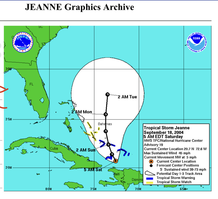
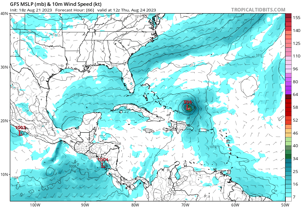
gatorcane wrote:Models have a come a long way since Jeanne not to mention it is no 2004 as far as Bermuda High strength so far. While one cannot completely rule out that scenario, it looks unlikely. 18Z guidance below;

https://i.postimg.cc/MT5PJLRh/08-L-tracks-18z.png


True about the models being a lot better now but I do think we see some west shifts. Probably not all the way to the CONUS though.
0 likes   

User avatar
Spacecoast
Category 2
Category 2
Posts: 687
Joined: Thu Aug 31, 2017 2:03 pm

Re: ATL: FRANKLIN - Models

#76 Postby Spacecoast » Mon Aug 21, 2023 8:24 pm

0z Tracks: Short term change from 18z. Now through central DR, rather than Haiti/DR border.
Image
Last edited by Spacecoast on Mon Aug 21, 2023 9:26 pm, edited 1 time in total.
0 likes   

User avatar
ScottNAtlanta
Category 5
Category 5
Posts: 2006
Joined: Sat May 25, 2013 3:11 pm
Location: Atlanta, GA

Re: ATL: FRANKLIN - Models

#77 Postby ScottNAtlanta » Mon Aug 21, 2023 8:37 pm

GFS has always had an out to sea bias when looking past 72 hours. I think it corrects west.
2 likes   
The posts in this forum are NOT official forecast and should not be used as such. They are just the opinion of the poster and may or may not be backed by sound meteorological data. They are NOT endorsed by any professional institution or storm2k.org. For official information, please refer to the NHC and NWS products.

User avatar
ElectricStorm
Category 5
Category 5
Posts: 4597
Age: 23
Joined: Tue Aug 13, 2019 11:23 pm
Location: Skiatook, OK / Norman, OK

Re: ATL: FRANKLIN - Models

#78 Postby ElectricStorm » Tue Aug 22, 2023 1:07 am

0z hurricane models:

HWRF gets to 984mb before Hispaniola
HMON 991mb at landfall
HAFS-A stays very weak and disorganized until north of the islands. 967mb at the end of the run
HAFS-B gets to 994mb before landfall, 974 at end of run
0 likes   
I am in no way a professional. Take what I say with a grain of salt as I could be totally wrong. Please refer to the NHC, NWS, or SPC for official information.

Boomer Sooner!

User avatar
kevin
Category 5
Category 5
Posts: 1771
Age: 25
Joined: Wed Aug 28, 2019 4:35 am

Re: ATL: FRANKLIN - Models

#79 Postby kevin » Tue Aug 22, 2023 3:13 am

00z HWRF is very aggressive and intensifies from 996 mb to 984 mb between +24 and +30 hrs just before landfall. Afterwards it also shows fast intensification with a 949 mb MH at the end of the run moving NW after a Jeanne-like loop a bit further east (which can better be seen in the HWRF-parent).


HWRF-p

0 likes   

User avatar
ScottNAtlanta
Category 5
Category 5
Posts: 2006
Joined: Sat May 25, 2013 3:11 pm
Location: Atlanta, GA

Re: ATL: FRANKLIN - Models

#80 Postby ScottNAtlanta » Tue Aug 22, 2023 9:03 am

It looks really awful this morning. It looks like an open wave almost. I do think this could be dangerous in the long term as it could miss the trough and head west.
1 likes   
The posts in this forum are NOT official forecast and should not be used as such. They are just the opinion of the poster and may or may not be backed by sound meteorological data. They are NOT endorsed by any professional institution or storm2k.org. For official information, please refer to the NHC and NWS products.


Return to “2023”

Who is online

Users browsing this forum: No registered users and 15 guests