
EPAC: BEATRIZ - Remnants - Discussion
Moderator: S2k Moderators
-
Sciencerocks
- Category 5

- Posts: 7287
- Age: 38
- Joined: Thu Jul 06, 2017 1:51 am
-
cycloneye

- Admin

- Posts: 139327
- Age: 67
- Joined: Thu Oct 10, 2002 10:54 am
- Location: San Juan, Puerto Rico
Re: EPAC: BEATRIZ - Hurricane - Discussion
BULLETIN
Hurricane Beatriz Advisory Number 8
NWS National Hurricane Center Miami FL EP022023
400 PM CDT Fri Jun 30 2023
...AIR FORCE RESERVE HURRICANE HUNTERS FIND BEATRIZ A LITTLE
STRONGER...
...HURRICANE CONDITIONS EXPECTED ALONG THE COASTS OF MICHOACAN,
COLIMA, AND JALISCO THROUGH SATURDAY...
SUMMARY OF 400 PM CDT...2100 UTC...INFORMATION
----------------------------------------------
LOCATION...17.8N 103.1W
ABOUT 60 MI...100 KM WSW OF LAZARO CARDENAS MEXICO
ABOUT 115 MI...185 KM SE OF MANZANILLO MEXICO
MAXIMUM SUSTAINED WINDS...85 MPH...140 KM/H
PRESENT MOVEMENT...NW OR 310 DEGREES AT 13 MPH...20 KM/H
MINIMUM CENTRAL PRESSURE...992 MB...29.30 INCHES
Hurricane Beatriz Discussion Number 8
NWS National Hurricane Center Miami FL EP022023
400 PM CDT Fri Jun 30 2023
An Air Force Reserve Hurricane Hunter aircraft investigated Beatriz
a couple of hours ago and measured peak 700-mb flight-level winds
of 84 kt and SFMR surface winds around 70 kt, and based on that
data, Beatriz's initial intensity is 75 kt. Since that time, the
eye which had become apparent in satellite imagery has become
obscured, and it's possible that the hurricane's structure is
beginning to be affected by the nearby mountainous terrain of
Mexico.
Beatriz continues to move northwestward, or 305/11 kt, and that
general motion should continue for the next 36 hours or so while
the hurricane moves along the southwestern periphery of a mid-level
ridge located over northern Mexico and the western Gulf of Mexico.
On this trajectory, Beatriz will continue to graze the coast of
southwestern Mexico during the next 24 hours, but any wobble to the
right of the forecast track could bring the center inland during
that time. If Beatriz survives the next 36 hours, another
mid-tropospheric ridge is expected to build over the southwestern
United States, causing the cyclone to turn west-northwestward and
then westward and slow down on days 2 and 3. There is a fair
amount of model spread during that period, and the updated NHC
track forecast is closest to the GFS, TVCE, and HCCA aids, nudged a
bit to the right of the previous forecast.
Beatriz is expected to remain a hurricane during the next 24 hours
if its center remains over water, but the mountainous terrain could
cause some slow weakening regardless. After 36 hours, increasing
shear, cooler sea surface temperatures, and a drier, more subsident
atmosphere are expected to contribute to faster weakening as
Beatriz moves away from west-central Mexico. Most of the global
models, with the exception of the GFS, dissipate the circulation by
day 3, so the new NHC forecast now shows Beatriz degenerating into
a remnant low by day 3, with dissipation occurring by day 4.
KEY MESSAGES:
1. Beatriz is forecast to remain a hurricane for the next day or
so, bringing a risk of hurricane-force winds and a dangerous storm
surge to portions of the southwestern coast of Mexico through
Saturday afternoon. A Hurricane Warning remains in effect for
portions of the coasts of Guerrero, Michoacan, Colima, and Jalisco.
2. Locally heavy rainfall is expected across southern and western
Mexico from the state of Guerrero northwestward to the states of
Sinaloa and Durango. These rains could lead to life-threatening
flash flooding and mudslides.
FORECAST POSITIONS AND MAX WINDS
INIT 30/2100Z 17.8N 103.1W 75 KT 85 MPH
12H 01/0600Z 19.0N 104.5W 70 KT 80 MPH
24H 01/1800Z 20.1N 106.0W 65 KT 75 MPH
36H 02/0600Z 21.1N 107.2W 60 KT 70 MPH
48H 02/1800Z 21.7N 108.3W 50 KT 60 MPH
60H 03/0600Z 22.0N 108.9W 40 KT 45 MPH
72H 03/1800Z 22.1N 109.4W 30 KT 35 MPH...POST-TROP/REMNT LOW
96H 04/1800Z...DISSIPATED
$$
Forecaster Berg
0 likes
Visit the Caribbean-Central America Weather Thread where you can find at first post web cams,radars
and observations from Caribbean basin members Click Here
and observations from Caribbean basin members Click Here

Re: EPAC: BEATRIZ - Hurricane - Discussion
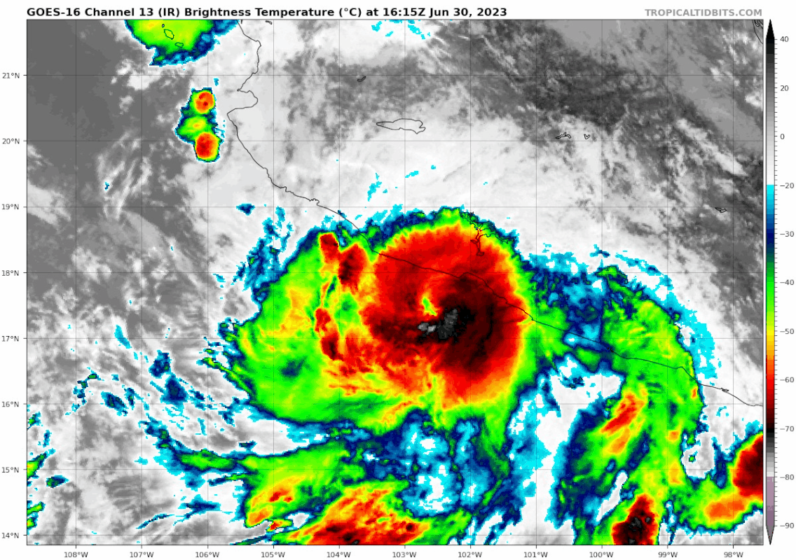
For being a 75 kt hurricane, the current apparance of Beatriz is making a run at the "Ugliest storms ever" thread.
3 likes
-
Sciencerocks
- Category 5
- Posts: 7287
- Age: 38
- Joined: Thu Jul 06, 2017 1:51 am
-
Kingarabian

- S2K Supporter

- Posts: 15451
- Joined: Sat Aug 08, 2009 3:06 am
- Location: Honolulu, Hawaii
Re: EPAC: BEATRIZ - Hurricane - Discussion
18z GFS kills this in 18-24 hours.
4 likes
RIP Kobe Bryant
-
cycloneye
- Admin
- Posts: 139327
- Age: 67
- Joined: Thu Oct 10, 2002 10:54 am
- Location: San Juan, Puerto Rico
Re: EPAC: BEATRIZ - Hurricane - Discussion
BULLETIN
Hurricane Beatriz Intermediate Advisory Number 8A
NWS National Hurricane Center Miami FL EP022023
700 PM CDT Fri Jun 30 2023
...BEATRIZ VERY NEAR THE COAST OF SOUTHWESTERN MEXICO...
...HURRICANE CONDITIONS AND HEAVY RAIN EXPECTED THROUGH SATURDAY...
SUMMARY OF 700 PM CDT...0000 UTC...INFORMATION
----------------------------------------------
LOCATION...18.1N 103.4W
ABOUT 70 MI...130 KM SE OF MANZANILLO MEXICO
MAXIMUM SUSTAINED WINDS...85 MPH...140 KM/H
PRESENT MOVEMENT...NW OR 310 DEGREES AT 13 MPH...20 KM/H
MINIMUM CENTRAL PRESSURE...992 MB...29.30 INCHES
0 likes
Visit the Caribbean-Central America Weather Thread where you can find at first post web cams,radars
and observations from Caribbean basin members Click Here
and observations from Caribbean basin members Click Here
-
Sciencerocks
- Category 5
- Posts: 7287
- Age: 38
- Joined: Thu Jul 06, 2017 1:51 am
-
Sciencerocks
- Category 5
- Posts: 7287
- Age: 38
- Joined: Thu Jul 06, 2017 1:51 am

-
cycloneye
- Admin
- Posts: 139327
- Age: 67
- Joined: Thu Oct 10, 2002 10:54 am
- Location: San Juan, Puerto Rico
Re: EPAC: BEATRIZ - Hurricane - Discussion
BULLETIN
Hurricane Beatriz Advisory Number 9
NWS National Hurricane Center Miami FL EP022023
1000 PM CDT Fri Jun 30 2023
...BEATRIZ VERY NEAR THE COAST OF SOUTHWESTERN MEXICO...
...HURRICANE CONDITIONS AND HEAVY RAIN EXPECTED TO CONTINUE INTO
SATURDAY...
SUMMARY OF 1000 PM CDT...0300 UTC...INFORMATION
-----------------------------------------------
LOCATION...18.4N 103.9W
ABOUT 50 MI...80 KM SSE OF MANZANILLO MEXICO
MAXIMUM SUSTAINED WINDS...85 MPH...140 KM/H
PRESENT MOVEMENT...NW OR 305 DEGREES AT 12 MPH...19 KM/H
MINIMUM CENTRAL PRESSURE...992 MB...29.30 INCHES]
Hurricane Beatriz Discussion Number 9
NWS National Hurricane Center Miami FL EP022023
1000 PM CDT Fri Jun 30 2023
Beatriz continues to move along the coast of southwestern Mexico
with the core of the hurricane now approaching Manzanillo. Although
the center remains just offshore, numerous rainbands are inland and
likely producing hurricane and tropical storm conditions along the
immediate coast. The hurricane is quite compact with its outer
tropical-storm-force wind field estimated to extent only up to 80 n
mi from the center. The initial initial intensity is held at 75 kt,
but this could be a little generous and is above the subjective
Dvorak estimates from TAFB and SAB.
The future intensity of Beatriz is quite dependent on how much the
hurricane interacts with land. Most of the global models show the
system weakening significantly or dissipating entirely as soon as in
24 hours due to the interaction with land. However, if the storm
manages to stay offshore, it will likely weaken at a much more
gradual pace. The NHC intensity forecast is lower than the previous
one and shows dissipation occurring a little sooner, trending toward
the latest global model solutions.
The hurricane continues to move northwestward at 10 kt on the
southwestern periphery of a mid-level ridge. This general motion
should continue during the next 12 to 24 hours, taking the core of
Beatriz along or just offshore of the coast of southwestern and
west-central Mexico. After that time, assuming the storm survives,
a slower westward to west-northwestward motion is expected. The NHC
track forecast is quite similar to the previous one and a little to
the south of the consensus aids.
KEY MESSAGES:
1. Beatriz is forecast to remain a hurricane through early
Saturday, bringing a risk of hurricane-force winds and a dangerous
storm surge to portions of the southwestern coast of Mexico. A
Hurricane Warning remains in effect for portions of the coasts of
Guerrero, Michoacan, Colima, and Jalisco.
2. Locally heavy rainfall is expected across southern and western
Mexico from the state of Guerrero northwestward to the states of
Sinaloa and Durango. These rains could lead to life-threatening
flash flooding and mudslides.
FORECAST POSITIONS AND MAX WINDS
INIT 01/0300Z 18.4N 103.9W 75 KT 85 MPH
12H 01/1200Z 19.5N 105.3W 65 KT 75 MPH
24H 02/0000Z 20.6N 106.5W 55 KT 65 MPH
36H 02/1200Z 21.4N 107.4W 50 KT 60 MPH
48H 03/0000Z 21.8N 108.0W 45 KT 50 MPH
60H 03/1200Z 22.0N 108.7W 35 KT 40 MPH
72H 04/0000Z...DISSIPATED
$$
Forecaster Cangialosi
0 likes
Visit the Caribbean-Central America Weather Thread where you can find at first post web cams,radars
and observations from Caribbean basin members Click Here
and observations from Caribbean basin members Click Here
-
Sciencerocks
- Category 5
- Posts: 7287
- Age: 38
- Joined: Thu Jul 06, 2017 1:51 am

-
MarioProtVI
- Category 2

- Posts: 671
- Age: 22
- Joined: Sun Sep 29, 2019 7:33 pm
- Location: New Jersey
Re: EPAC: BEATRIZ - Hurricane - Discussion
This straight up collapsed within the span of 6 hours. Convection very skimpy and it’s likely not even a TC anymore as ASCAT failed to find the circulation where NHC has it. The mountains literally ripped this to shreds. See ya Beatriz!
2 likes
-
Sciencerocks
- Category 5
- Posts: 7287
- Age: 38
- Joined: Thu Jul 06, 2017 1:51 am

-
cycloneye
- Admin
- Posts: 139327
- Age: 67
- Joined: Thu Oct 10, 2002 10:54 am
- Location: San Juan, Puerto Rico
Re: EPAC: BEATRIZ - Tropical Storm - Discussion
Tropical Storm Beatriz Discussion Number 10
NWS National Hurricane Center Miami FL EP022023
400 AM CDT Sat Jul 01 2023
The center of Beatriz brushed the coast of Mexico near Punta San
Telmo back around 0000 UTC, and since then the cyclone has steadily
lost organization. Earlier microwave satellite imagery shows that
the eye has disappeared, while scatterometer and synthetic aperture
radar data suggest that the surface circulation has become less well
defined. In addition, surface observations in and around Manzanillo
have not been supportive of a well-defined circulation in the area.
Based on these observations and an accompanying decrease in the
satellite cloud pattern, the initial intensity is reduced to an
uncertain 55 kt.
Although Beatriz will be moving away from the coast of Mexico later
today, the dynamical models suggest that the cyclone will not
recover from the effects of land interaction, with most of them
forecasting the system to dissipate to 2-3 days time or less. The
new NHC intensity forecast is notably lower than the previous
forecast and calls for the system to weaken to a depression by 60 h
and dissipate soon thereafter. There is a chance that Beatriz could
weaken faster than currently forecast.
The initial motion is estimated at 315/11 kt as the cyclone
continues to move along the southwest periphery of a mid-level
ridge. This general motion should continue during the next 12-24
hours, taking the core of Beatriz along or just offshore of the
coast of southwestern and west-central Mexico this morning. After
that time, assuming the storm survives, a slower and generally
west-northwestward motion is expected. The NHC track forecast is
similar to, but a little faster than the previous forecast.
KEY MESSAGES:
1. Beatriz is forecast to bring tropical storm conditions to
portions of western Mexico today.
2. Locally heavy rainfall is expected across southern and western
Mexico from the state of Guerrero northwestward to the states of
Sinaloa and Durango. These rains could lead to life-threatening
flash flooding and mudslides.
FORECAST POSITIONS AND MAX WINDS
INIT 01/0900Z 19.4N 105.1W 55 KT 65 MPH
12H 01/1800Z 20.5N 106.4W 50 KT 60 MPH
24H 02/0600Z 21.5N 107.5W 45 KT 50 MPH
36H 02/1800Z 22.1N 108.3W 40 KT 45 MPH
48H 03/0600Z 22.4N 108.8W 35 KT 40 MPH
60H 03/1800Z 22.6N 109.3W 30 KT 35 MPH
72H 04/0600Z...DISSIPATED
$$
Forecaster Beven
0 likes
Visit the Caribbean-Central America Weather Thread where you can find at first post web cams,radars
and observations from Caribbean basin members Click Here
and observations from Caribbean basin members Click Here
-
Sciencerocks
- Category 5
- Posts: 7287
- Age: 38
- Joined: Thu Jul 06, 2017 1:51 am

-
cycloneye
- Admin
- Posts: 139327
- Age: 67
- Joined: Thu Oct 10, 2002 10:54 am
- Location: San Juan, Puerto Rico
Re: EPAC: BEATRIZ - Tropical Storm - Discussion
BULLETIN
Tropical Storm Beatriz Intermediate Advisory Number 10A
NWS National Hurricane Center Miami FL EP022023
700 AM CDT Sat Jul 01 2023
...BEATRIZ ALONG THE COAST OF JALISCO...
...HEAVY RAINS AND GUSTY WINDS CONTINUE WITHIN THE WARNING AREAS...
SUMMARY OF 700 AM CDT...1200 UTC...INFORMATION
----------------------------------------------
LOCATION...19.8N 105.4W
ABOUT 45 MI...75 KM SSE OF CABO CORRIENTES MEXICO
ABOUT 90 MI...145 KM NW OF MANZANILLO MEXICO
MAXIMUM SUSTAINED WINDS...60 MPH...95 KM/H
PRESENT MOVEMENT...NW OR 315 DEGREES AT 13 MPH...20 KM/H
MINIMUM CENTRAL PRESSURE...1001 MB...29.56 INCHES
Tropical Storm Beatriz Discussion Number 11
NWS National Hurricane Center Miami FL EP022023
1000 AM CDT Sat Jul 01 2023
It's a bit of a mystery if Beatriz still has a surface circulation
this morning. Microwave data and UW-CIMSS's animated MIMIC-TC
product suggest that a center of rotation, at least in the middle
levels of the atmosphere, is now located just off the coast of Cabo
Corrientes, Mexico, and that position closely matches an
extrapolated position from previous forecasts. The system is still
producing deep convection around this center feature, although
satellite intensity estimates have been decreasing fast. The
initial intensity is lowered to an uncertain 45 kt.
Beatriz may have sped up slightly overnight, but the longer-term
motion remains northwestward (315 degrees) at 11 kt. A weakening
mid-level ridge over northeastern Mexico should keep Beatriz on a
northwestward path, at a slower speed, during the next 24 hours.
On Sunday and Monday, the low- to mid-level steering currents
collapse, and Beatriz or its remnants are likely to drift toward
the west-northwest or meander over the mouth of the Gulf of
California. Since many of the global models show Beatriz already
having dissipated, there were relatively few model trackers
available for this forecast. In general, the NHC track forecast is
close to a blend of the TVCE and HCCA consensus aids.
With Beatriz's severely disrupted circulation and less favorable
atmospheric conditions, continued weakening is expected. The
ECWMF, UKMET, and Canadian model fields indicate that Beatriz's
circulation may have already dissipated, while the GFS shows a
circulation winding down and dissipating in 2-3 days. The NHC
intensity forecast shows faster weakening than the previous
prediction, with degeneration into a remnant low by 48 hours.
However, it's possible that advisories could be discontinued at any
time if we receive data that shows the circulation has dissipated
and the system is no longer producing tropical-storm-force winds.
KEY MESSAGES:
1. Tropical storm conditions along the west-central coast of Mexico
are forecast to diminish this afternoon as Beatriz begins to move
away from the area.
2. Locally heavy rainfall is expected across southern and western
Mexico from Colima northwestward to Sinaloa and Durango. These
rains could lead to life-threatening flash flooding and mudslides.
FORECAST POSITIONS AND MAX WINDS
INIT 01/1500Z 20.4N 105.9W 45 KT 50 MPH
12H 02/0000Z 21.4N 107.0W 35 KT 40 MPH
24H 02/1200Z 22.2N 108.0W 30 KT 35 MPH
36H 03/0000Z 22.5N 108.6W 25 KT 30 MPH
48H 03/1200Z 22.7N 108.9W 20 KT 25 MPH...POST-TROP/REMNT LOW
60H 04/0000Z 22.7N 109.0W 20 KT 25 MPH...POST-TROP/REMNT LOW
72H 04/1200Z...DISSIPATED
$$
Forecaster Berg
0 likes
Visit the Caribbean-Central America Weather Thread where you can find at first post web cams,radars
and observations from Caribbean basin members Click Here
and observations from Caribbean basin members Click Here
-
wxman57

- Moderator-Pro Met

- Posts: 22484
- Age: 66
- Joined: Sat Jun 21, 2003 8:06 pm
- Location: Houston, TX (southwest)
Re: EPAC: BEATRIZ - Tropical Storm - Discussion
Bones says he has seen enough of Beatriz. Wind observations from Manzanillo and Puerto Vallarta didn't even indicate the passage of a circulation overnight. Bye, Beatriz.

1 likes
-
Sciencerocks
- Category 5
- Posts: 7287
- Age: 38
- Joined: Thu Jul 06, 2017 1:51 am

-
cycloneye
- Admin
- Posts: 139327
- Age: 67
- Joined: Thu Oct 10, 2002 10:54 am
- Location: San Juan, Puerto Rico
Re: EPAC: BEATRIZ - Remnants - Discussion
Remnants Of Beatriz Special Discussion Number 12
NWS National Hurricane Center Miami FL EP022023
1200 PM MDT Sat Jul 01 2023
A just-received ASCAT pass indicates that Beatriz has dissipated.
There is no longer a surface circulation, and the maximum winds are
around 25 kt, associated with a squall line that recently moved
northward across Las Islas Marias. As a result, this special
advisory will be the last advisory on this system.
The government of Mexico has discontinued all watches and warnings
along the coast of west-central Mexico and Las Islas Marias.
For additional information on the remnants, please see High Seas
Forecasts issued by the National Weather Service, under AWIPS
header NFDHSFEPI, WMO header FZPN02 KWBC, and on the web at
ocean.weather.gov/shtml/NFDHSFEPI.php
FORECAST POSITIONS AND MAX WINDS
INIT 01/1800Z 20.7N 106.2W 25 KT 30 MPH...REMNANTS OF BEATRIZ
12H 02/0000Z...DISSIPATED
$$
Forecaster Berg
0 likes
Visit the Caribbean-Central America Weather Thread where you can find at first post web cams,radars
and observations from Caribbean basin members Click Here
and observations from Caribbean basin members Click Here
-
Hurricane2022

- Category 4

- Posts: 945
- Joined: Tue Aug 23, 2022 11:38 pm
- Location: Araçatuba, Brazil
Re: EPAC: BEATRIZ - Hurricane - Discussion
Kingarabian wrote:18z GFS kills this in 18-24 hours.
GFS was right
3 likes
Sorry for the bad English sometimes...!
For reliable and detailed information for any meteorological phenomenon, please consult the National Hurricane Center, Joint Typhoon Warning Center , or your local Meteo Center.
--------
Una cvm Christo, pro Christo, et in Christo. Sit nomen Domini benedictvm.
For reliable and detailed information for any meteorological phenomenon, please consult the National Hurricane Center, Joint Typhoon Warning Center , or your local Meteo Center.
--------
Una cvm Christo, pro Christo, et in Christo. Sit nomen Domini benedictvm.
Who is online
Users browsing this forum: No registered users and 29 guests