EP, 01, 2023062812, , BEST, 0, 152N, 1078W, 65, 989, HU
EPAC: ADRIAN - Post-Tropical - Discussion
Moderator: S2k Moderators
-
Extratropical94

- Professional-Met

- Posts: 3535
- Age: 29
- Joined: Wed Oct 20, 2010 6:36 am
- Location: Hamburg, Germany
- Contact:
Re: EPAC: ADRIAN - Tropical Storm - Discussion
12Z BT makes Adrian a hurricane, regardless of that 3.0
0 likes
54° 11' 59'' N, 9° 9' 20'' E
Boomer Sooner!
Go Broncos! Go Cards! Go Niners!
- Daniel
Boomer Sooner!
Go Broncos! Go Cards! Go Niners!
- Daniel
-
Kingarabian

- S2K Supporter

- Posts: 15451
- Joined: Sat Aug 08, 2009 3:06 am
- Location: Honolulu, Hawaii
Re: EPAC: ADRIAN - Tropical Storm - Discussion
Yeah for sure its a hurricane. It is gulping dry air at a good rate though.
1 likes
RIP Kobe Bryant
-
Kingarabian
- S2K Supporter
- Posts: 15451
- Joined: Sat Aug 08, 2009 3:06 am
- Location: Honolulu, Hawaii
Re: EPAC: ADRIAN - Tropical Storm - Discussion
Clearly a hurricane and likely a Cat.2.
3 likes
RIP Kobe Bryant
-
cycloneye

- Admin

- Posts: 139327
- Age: 67
- Joined: Thu Oct 10, 2002 10:54 am
- Location: San Juan, Puerto Rico
Re: EPAC: ADRIAN - Hurricane - Discussion
BULLETIN
Hurricane Adrian Advisory Number 4
NWS National Hurricane Center Miami FL EP012023
900 AM MDT Wed Jun 28 2023
...ADRIAN RAPIDLY INTENSIFIES INTO A HURRICANE...
SUMMARY OF 900 AM MDT...1500 UTC...INFORMATION
----------------------------------------------
LOCATION...15.2N 108.0W
ABOUT 360 MI...575 KM SW OF MANZANILLO MEXICO
MAXIMUM SUSTAINED WINDS...75 MPH...120 KM/H
PRESENT MOVEMENT...W OR 270 DEGREES AT 8 MPH...13 KM/H
MINIMUM CENTRAL PRESSURE...989 MB...29.21 INCHES
Hurricane Adrian Discussion Number 4
NWS National Hurricane Center Miami FL EP012023
900 AM MDT Wed Jun 28 2023
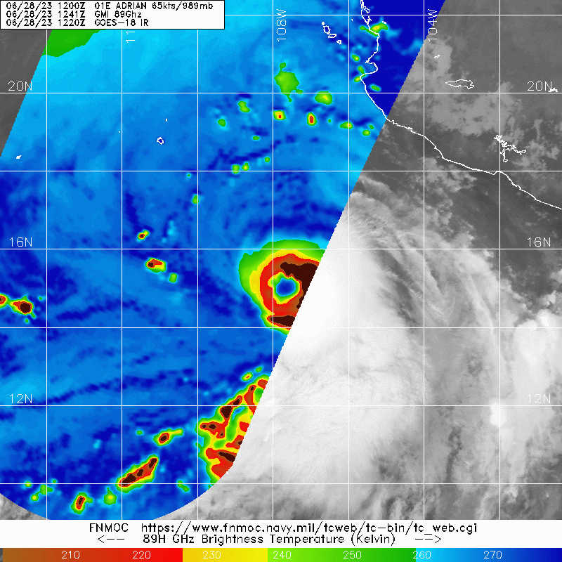
Recent SSMIS and GMI microwave images reveal that Adrian has
developed a well-defined eye, although that feature is obscured in
conventional visible and infrared satellite imagery by the Central
Dense Overcast (CDO). This structure indicates that Adrian has
become a hurricane, and the initial intensity is set at 65 kt as a
blend of the most recent objective and subjective satellite
intensity estimates. Based on this estimate, Adrian has rapidly
intensified during the past 24 hours. Upper-level outflow is
slightly restricted within the northeastern quadrant, and a
slight offset of the low- and mid-level eyes in the microwave
data suggest there could be some mid-level northerly shear affecting
the hurricane.
Adrian is moving westward, or 270/7 kt, to the south of a
mid-tropospheric ridge which extends westward from northern Mexico.
This ridge is expected to weaken during the next 2 days as a
mid-level trough develops west of the Baja California peninsula,
and this should cause Adrian to slow down further and turn toward
the west-northwest by 48 hours. Although the ridge restrengthens
north of Adrian by day 4, the hurricane may begin to interact with
another weather disturbance (EP92) to its east, and the track
models respond by showing Adrian becoming nearly stationary or
meandering by the end of the forecast period. That said, there is
less-than-normal spread among the track models, and the NHC track
forecast is very close to the previous prediction.
Model guidance suggests that mid-level shear could continue to
affect Adrian, otherwise the deep-layer shear remains low for the
next 48 hours. Along with water temperatures of around 28 degrees
Celsius, these conditions should allow Adrian to strengthen
further. However, easterly shear is forecast to increase in earnest
by 48 hours, and the updated NHC intensity forecast therefore shows
faster weakening after that time (although it is still above the
HCCA and IVCN consensus aids). Adrian is now shown as a
post-tropical remnant low by day 5 due to the expected effects of
continued shear and cooler waters.
FORECAST POSITIONS AND MAX WINDS
INIT 28/1500Z 15.2N 108.0W 65 KT 75 MPH
12H 29/0000Z 15.4N 109.3W 70 KT 80 MPH
24H 29/1200Z 15.6N 110.8W 75 KT 85 MPH
36H 30/0000Z 15.8N 112.0W 80 KT 90 MPH
48H 30/1200Z 16.1N 113.2W 75 KT 85 MPH
60H 01/0000Z 16.4N 114.3W 70 KT 80 MPH
72H 01/1200Z 16.8N 115.3W 60 KT 70 MPH
96H 02/1200Z 17.4N 116.7W 40 KT 45 MPH
120H 03/1200Z 17.5N 117.7W 25 KT 30 MPH...POST-TROP/REMNT LOW
$$
Forecaster Berg
Hurricane Adrian Advisory Number 4
NWS National Hurricane Center Miami FL EP012023
900 AM MDT Wed Jun 28 2023
...ADRIAN RAPIDLY INTENSIFIES INTO A HURRICANE...
SUMMARY OF 900 AM MDT...1500 UTC...INFORMATION
----------------------------------------------
LOCATION...15.2N 108.0W
ABOUT 360 MI...575 KM SW OF MANZANILLO MEXICO
MAXIMUM SUSTAINED WINDS...75 MPH...120 KM/H
PRESENT MOVEMENT...W OR 270 DEGREES AT 8 MPH...13 KM/H
MINIMUM CENTRAL PRESSURE...989 MB...29.21 INCHES
Hurricane Adrian Discussion Number 4
NWS National Hurricane Center Miami FL EP012023
900 AM MDT Wed Jun 28 2023
Recent SSMIS and GMI microwave images reveal that Adrian has
developed a well-defined eye, although that feature is obscured in
conventional visible and infrared satellite imagery by the Central
Dense Overcast (CDO). This structure indicates that Adrian has
become a hurricane, and the initial intensity is set at 65 kt as a
blend of the most recent objective and subjective satellite
intensity estimates. Based on this estimate, Adrian has rapidly
intensified during the past 24 hours. Upper-level outflow is
slightly restricted within the northeastern quadrant, and a
slight offset of the low- and mid-level eyes in the microwave
data suggest there could be some mid-level northerly shear affecting
the hurricane.
Adrian is moving westward, or 270/7 kt, to the south of a
mid-tropospheric ridge which extends westward from northern Mexico.
This ridge is expected to weaken during the next 2 days as a
mid-level trough develops west of the Baja California peninsula,
and this should cause Adrian to slow down further and turn toward
the west-northwest by 48 hours. Although the ridge restrengthens
north of Adrian by day 4, the hurricane may begin to interact with
another weather disturbance (EP92) to its east, and the track
models respond by showing Adrian becoming nearly stationary or
meandering by the end of the forecast period. That said, there is
less-than-normal spread among the track models, and the NHC track
forecast is very close to the previous prediction.
Model guidance suggests that mid-level shear could continue to
affect Adrian, otherwise the deep-layer shear remains low for the
next 48 hours. Along with water temperatures of around 28 degrees
Celsius, these conditions should allow Adrian to strengthen
further. However, easterly shear is forecast to increase in earnest
by 48 hours, and the updated NHC intensity forecast therefore shows
faster weakening after that time (although it is still above the
HCCA and IVCN consensus aids). Adrian is now shown as a
post-tropical remnant low by day 5 due to the expected effects of
continued shear and cooler waters.
FORECAST POSITIONS AND MAX WINDS
INIT 28/1500Z 15.2N 108.0W 65 KT 75 MPH
12H 29/0000Z 15.4N 109.3W 70 KT 80 MPH
24H 29/1200Z 15.6N 110.8W 75 KT 85 MPH
36H 30/0000Z 15.8N 112.0W 80 KT 90 MPH
48H 30/1200Z 16.1N 113.2W 75 KT 85 MPH
60H 01/0000Z 16.4N 114.3W 70 KT 80 MPH
72H 01/1200Z 16.8N 115.3W 60 KT 70 MPH
96H 02/1200Z 17.4N 116.7W 40 KT 45 MPH
120H 03/1200Z 17.5N 117.7W 25 KT 30 MPH...POST-TROP/REMNT LOW
$$
Forecaster Berg
1 likes
Visit the Caribbean-Central America Weather Thread where you can find at first post web cams,radars
and observations from Caribbean basin members Click Here
and observations from Caribbean basin members Click Here
-
Sciencerocks
- Category 5

- Posts: 7287
- Age: 38
- Joined: Thu Jul 06, 2017 1:51 am

-
Sciencerocks
- Category 5
- Posts: 7287
- Age: 38
- Joined: Thu Jul 06, 2017 1:51 am

-
Yellow Evan

- Professional-Met
- Posts: 15956
- Age: 25
- Joined: Fri Jul 15, 2011 12:48 pm
- Location: Henderson, Nevada/Honolulu, HI
- Contact:
Re: EPAC: ADRIAN - Hurricane - Discussion
Dealing with dry air so intensification on pause for the rest of the day. There remains a window of opportunity for a stronger system once it recovers and ML shear trickles down a bit tomorrow. I would probably forecast 90 knots.
0 likes
-
Yellow Evan
- Professional-Met
- Posts: 15956
- Age: 25
- Joined: Fri Jul 15, 2011 12:48 pm
- Location: Henderson, Nevada/Honolulu, HI
- Contact:
Re: EPAC: ADRIAN - Hurricane - Discussion
TXPZ24 KNES 281829
TCSENP
A. 01E (ADRIAN)
B. 28/1800Z
C. 15.3N
D. 108.0W
E. THREE/GOES-W
F. T4.5/4.5
G. IR/EIR/VIS/GMI/SSMIS
H. REMARKS...AN LLCC EMBEDDED IN MG RESULTS IN A DT OF 4.0. THE MET IS
3.0 DUE TO RAPID DEVELOPMENT OVER 24 HOURS. THE PT IS 3.5. THE 6-HOUR
AVERAGE DT OF 4.5 JUSTIFIES BREAKING CONSTRAINTS. THE FT IS BASED ON
THE 6 HOUR AVERAGE DT.
I. ADDL POSITIONS
28/1220Z 15.2N 107.7W GMI
28/1359Z 15.2N 107.8W SSMIS
...BROWN
0 likes
-
cycloneye
- Admin
- Posts: 139327
- Age: 67
- Joined: Thu Oct 10, 2002 10:54 am
- Location: San Juan, Puerto Rico
Re: EPAC: ADRIAN - Hurricane - Discussion
EP, 01, 2023062818, , BEST, 0, 153N, 1081W, 70, 986, HU
0 likes
Visit the Caribbean-Central America Weather Thread where you can find at first post web cams,radars
and observations from Caribbean basin members Click Here
and observations from Caribbean basin members Click Here


Re: EPAC: ADRIAN - Hurricane - Discussion
UW - CIMSS
ADVANCED DVORAK TECHNIQUE
ADT-Version 9.1
Tropical Cyclone Intensity Algorithm
----- Current Analysis -----
Date : 28 JUN 2023 Time : 184020 UTC
Lat : 15:15:46 N Lon : 108:27:47 W
CI# /Pressure/ Vmax
4.5 / 976.6mb/ 77.0kt
Final T# Adj T# Raw T#
4.5 4.5 5.3
Estimated radius of max. wind based on IR :N/A km
Center Temp : -25.5C Cloud Region Temp : -60.1C
Scene Type : EYE
Subtropical Adjustment : OFF
Extratropical Adjustment : OFF
Positioning Method : FORECAST INTERPOLATION
0 likes
The above post and any post by Ntxw is NOT an official forecast and should not be used as such. It is just the opinion of the poster and may or may not be backed by sound meteorological data. It is NOT endorsed by any professional institution including Storm2k. For official information, please refer to NWS products.
Help support Storm2K!

-
ElectricStorm

- Category 5
- Posts: 4597
- Age: 23
- Joined: Tue Aug 13, 2019 11:23 pm
- Location: Skiatook, OK / Norman, OK
Re: EPAC: ADRIAN - Hurricane - Discussion
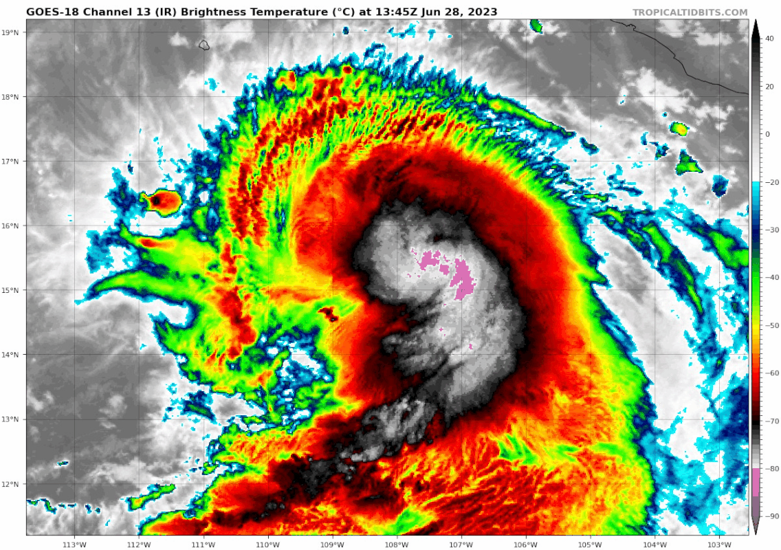
Looking pretty bad right now on IR with the CDO warming significantly. But ADT keeps rising and NHC increased to 70kts so I guess it's stronger than it looks.
0 likes
I am in no way a professional. Take what I say with a grain of salt as I could be totally wrong. Please refer to the NHC, NWS, or SPC for official information.
Boomer Sooner!
Boomer Sooner!
-
Kingarabian
- S2K Supporter
- Posts: 15451
- Joined: Sat Aug 08, 2009 3:06 am
- Location: Honolulu, Hawaii
Re: EPAC: ADRIAN - Hurricane - Discussion
Think it has peaked here unless hot towers go off. CDO convection to the N/NW is very shallow.
0 likes
RIP Kobe Bryant
-
cainjamin

- Tropical Storm

- Posts: 163
- Age: 33
- Joined: Mon Apr 17, 2017 1:38 pm
- Location: Nova Scotia, Canada
Re: EPAC: ADRIAN - Hurricane - Discussion
Looks like it took a gulp of some dry air. Eye is clearing out on visible but eyewall convection is patchy and shallow at best.
0 likes
Noel '07, Kyle '08, Earl '10, Arthur '14, Dorian '19, Teddy '20, Lee '23
-
cycloneye
- Admin
- Posts: 139327
- Age: 67
- Joined: Thu Oct 10, 2002 10:54 am
- Location: San Juan, Puerto Rico
Re: EPAC: ADRIAN - Hurricane - Discussion
BULLETIN
Hurricane Adrian Advisory Number 5
NWS National Hurricane Center Miami FL EP012023
300 PM MDT Wed Jun 28 2023
...ADRIAN STRENGTHENS A LITTLE WHILE MOVING SLOWLY WESTWARD...
SUMMARY OF 300 PM MDT...2100 UTC...INFORMATION
----------------------------------------------
LOCATION...15.3N 108.4W
ABOUT 370 MI...600 KM SW OF MANZANILLO MEXICO
MAXIMUM SUSTAINED WINDS...80 MPH...130 KM/H
PRESENT MOVEMENT...W OR 275 DEGREES AT 6 MPH...9 KM/H
MINIMUM CENTRAL PRESSURE...986 MB...29.12 INCHES
Hurricane Adrian Discussion Number 5
NWS National Hurricane Center Miami FL EP012023
300 PM MDT Wed Jun 28 2023
Despite the well-defined structure noted in microwave imagery from
this morning, Adrian's visible and infrared satellite presentation
is quite ragged. An eye appears to be forming, but deep convection
appears thin within the northern eyewall, possibly due to continued
northerly shear beneath the outflow level. Still, both subjective
and objective satellite intensity estimates have risen since this
morning, and Adrian's initial intensity is therefore set at 70 kt.
Recent fixes suggest the hurricane has slowed down, and the initial
motion estimate is westward, or 275/5 kt. Mid-tropospheric ridging
to the north of Adrian is expected to weaken during the next couple
of days as a mid-level trough develops west of the Baja California
peninsula, and that should keep the hurricane's forward motion
relatively slow toward the west or west-northwest for the entire
forecast period. The NHC track forecast is close to the various
consensus aids, and the guidance envelope is tightly clustered
through at least day 3. However, it's notable that the HCCA aid
is slower than much of the other guidance, and given Adrian's
recent slower-than-expected motion, it's possible that future
forecasts could be slowed down further to account for this trend.
There is a noticeable dichotomy in the intensity guidance, with the
statistical-dynamical SHIPS and LGEM models showing much more
additional intensification compared to the dynamical models and
consensus aids, which show Adrian's intensity flat-lining soon. A
little more strengthening is indicated in the NHC intensity
forecast since vertical shear is expected to be low for the next 36
to 48 hours. Fast weakening is anticipated after 48 hours due to
a significant increase in easterly shear, as well as cooler waters.
Simulated satellite imagery from the GFS and ECWMF models suggests
that Adrian could lose deep convection by day 4, and the official
forecast therefore calls for the system to degenerate into a
remnant low around that time.
FORECAST POSITIONS AND MAX WINDS
INIT 28/2100Z 15.3N 108.4W 70 KT 80 MPH
12H 29/0600Z 15.5N 109.6W 75 KT 85 MPH
24H 29/1800Z 15.8N 111.0W 80 KT 90 MPH
36H 30/0600Z 16.1N 112.2W 75 KT 85 MPH
48H 30/1800Z 16.4N 113.4W 70 KT 80 MPH
60H 01/0600Z 16.8N 114.6W 60 KT 70 MPH
72H 01/1800Z 17.1N 115.5W 50 KT 60 MPH
96H 02/1800Z 17.6N 117.0W 30 KT 35 MPH...POST-TROP/REMNT LOW
120H 03/1800Z 17.6N 117.6W 20 KT 25 MPH...POST-TROP/REMNT LOW
$$
Forecaster Berg
0 likes
Visit the Caribbean-Central America Weather Thread where you can find at first post web cams,radars
and observations from Caribbean basin members Click Here
and observations from Caribbean basin members Click Here
-
Sciencerocks
- Category 5
- Posts: 7287
- Age: 38
- Joined: Thu Jul 06, 2017 1:51 am

-
Hurricane2022

- Category 4

- Posts: 945
- Joined: Tue Aug 23, 2022 11:38 pm
- Location: Araçatuba, Brazil
Re: EPAC: ADRIAN - Hurricane - Discussion
0 likes
Sorry for the bad English sometimes...!
For reliable and detailed information for any meteorological phenomenon, please consult the National Hurricane Center, Joint Typhoon Warning Center , or your local Meteo Center.
--------
Una cvm Christo, pro Christo, et in Christo. Sit nomen Domini benedictvm.
For reliable and detailed information for any meteorological phenomenon, please consult the National Hurricane Center, Joint Typhoon Warning Center , or your local Meteo Center.
--------
Una cvm Christo, pro Christo, et in Christo. Sit nomen Domini benedictvm.
-
ElectricStorm
- Category 5
- Posts: 4597
- Age: 23
- Joined: Tue Aug 13, 2019 11:23 pm
- Location: Skiatook, OK / Norman, OK
Re: EPAC: ADRIAN - Hurricane - Discussion
Well looks like the dry air issues didn't last long, much better convection wrapping around the eye now.
0 likes
I am in no way a professional. Take what I say with a grain of salt as I could be totally wrong. Please refer to the NHC, NWS, or SPC for official information.
Boomer Sooner!
Boomer Sooner!
-
Sciencerocks
- Category 5
- Posts: 7287
- Age: 38
- Joined: Thu Jul 06, 2017 1:51 am

-
Yellow Evan
- Professional-Met
- Posts: 15956
- Age: 25
- Joined: Fri Jul 15, 2011 12:48 pm
- Location: Henderson, Nevada/Honolulu, HI
- Contact:
Re: EPAC: ADRIAN - Hurricane - Discussion
TXPZ24 KNES 290023
TCSENP
A. 01E (ADRIAN)
B. 29/0000Z
C. 15.3N
D. 108.7W
E. ONE/GOES-W
F. T4.5/4.5
G. IR/EIR/VIS
H. REMARKS...OW EYE SURROUNDED BY LG AND EMBEDDED IN MG RESULTS IN AN
E# OF 4.5 WITH NO EADJ FOR A DT OF 4.5. 2049Z AMSR2 PASS SHOWED RATHER
LARGE MID-LVL EYE. SIG INCR IN BANDED DEEP CORE CONVECTION LAST SVRL
HR. UPR-LVL OUTFLOW VERY GOOD ALQDS XCPT SOMEWHAT RESTRICTED SW. MET=3.5
AND PT=4.0. FT BASED ON DT.
I. ADDL POSITIONS
NIL
...KONON
0 likes
Who is online
Users browsing this forum: No registered users and 16 guests