ATL: PHILIPPE - Models

Moderator: S2k Moderators

Message
Author
User avatar
Iceresistance
Category 5
Category 5
Posts: 8925
Age: 20
Joined: Sat Oct 10, 2020 9:45 am
Location: Tecumseh, OK/Norman, OK

Re: ATL: PHILIPPE - Models

#41 Postby Iceresistance » Thu Sep 28, 2023 9:52 am

This is a very difficult forecast

Image
https://s6.gifyu.com/images/S4O3w.jpg
3 likes   
Bill 2015 & Beta 2020

Winter 2020-2021 :cold:

All observations are in Tecumseh, OK unless otherwise noted.

Winter posts are focused mainly for Oklahoma & Texas.

Take any of my forecasts with a grain of salt, refer to the NWS, SPC, and NHC for official information

Never say Never with weather! Because ANYTHING is possible!

User avatar
cycloneye
Admin
Admin
Posts: 139329
Age: 67
Joined: Thu Oct 10, 2002 10:54 am
Location: San Juan, Puerto Rico

Re: ATL: PHILIPPE - Models

#42 Postby cycloneye » Thu Sep 28, 2023 2:26 pm

Good news for the NE Caribbean Islands.

Image
0 likes   
Visit the Caribbean-Central America Weather Thread where you can find at first post web cams,radars
and observations from Caribbean basin members Click Here

Craters
Category 1
Category 1
Posts: 349
Joined: Sat Aug 24, 2013 2:34 pm
Location: Alvin, TX (south of Houston)

ATL: RINA - Models

#43 Postby Craters » Thu Sep 28, 2023 5:59 pm

A new poster for the Tropical Meteorologists' Therapy Fund?

Image

Sorry that's for Philippe, but I couldn't resist. Mod -- please delete this if it's inappropriate. Thank you.
4 likes   
Nothing that I post here should ever be treated as a forecast or anything resembling one. Please check with your local NWS office or the NHC for forecasts, watches, and warnings.

User avatar
aspen
Category 5
Category 5
Posts: 8057
Joined: Sat Oct 12, 2019 7:10 pm
Location: Connecticut, USA

Re: ATL: PHILIPPE - Models

#44 Postby aspen » Fri Sep 29, 2023 5:05 am

The GFS, Euro, CMC, ICON, and HWRF all show Phillipe becoming the dominant system and intensifying into a hurricane as it heads north. The HAFS-A/B kill both systems.
0 likes   
Irene '11 Sandy '12 Hermine '16 5/15/2018 Derecho Fay '20 Isaias '20 Elsa '21 Henri '21 Ida '21

I am only a meteorology enthusiast who knows a decent amount about tropical cyclones. Look to the professional mets, the NHC, or your local weather office for the best information.

tolakram
Admin
Admin
Posts: 19171
Age: 60
Joined: Sun Aug 27, 2006 8:23 pm
Location: Florence, KY (name is Mark)

Re: ATL: PHILIPPE - Models

#45 Postby tolakram » Fri Sep 29, 2023 6:32 am

For all my criticism of the GFS, it seems to be consistently better with sheared systems. I believe it was the first to recognize Phil as winning, the Euro just came on board last night.

IF this actually happens, of course. For all I know all models will flip to Rina tomorrow.
3 likes   
M a r k
- - - - -
Join us in chat: Storm2K Chatroom Invite. Android and IOS apps also available.

The posts in this forum are NOT official forecasts and should not be used as such. Posts are NOT endorsed by any professional institution or STORM2K.org. For official information and forecasts, please refer to NHC and NWS products.

User avatar
Kazmit
Category 5
Category 5
Posts: 1915
Age: 21
Joined: Mon Jul 25, 2016 8:49 am
Location: Williamsburg VA for college, Bermuda otherwise

Re: ATL: PHILIPPE - Models

#46 Postby Kazmit » Fri Sep 29, 2023 11:57 am

GFS has been pretty consistent the past day or so with Phillippe deepening into a major while Rina dies out.
3 likes   
Igor 2010, Sandy 2012, Fay 2014, Gonzalo 2014, Joaquin 2015, Nicole 2016, Humberto 2019

I am only a tropical weather enthusiast. My predictions are not official and may or may not be backed by sound meteorological data. For official information, please refer to the NHC and NWS products.

User avatar
cycloneye
Admin
Admin
Posts: 139329
Age: 67
Joined: Thu Oct 10, 2002 10:54 am
Location: San Juan, Puerto Rico

Re: ATL: PHILIPPE - Models

#47 Postby cycloneye » Fri Sep 29, 2023 1:19 pm

12z ECMWF a little bit closer to Leewards but eventually goes north.

Image
0 likes   
Visit the Caribbean-Central America Weather Thread where you can find at first post web cams,radars
and observations from Caribbean basin members Click Here

User avatar
Woofde
Category 1
Category 1
Posts: 278
Joined: Tue Jul 06, 2021 11:33 am

Re: ATL: PHILIPPE - Models

#48 Postby Woofde » Fri Sep 29, 2023 1:50 pm

The 12z GFS keeps Philippe alive even past October 15th, taking it all the way to the canaries and then bouncing back to the open Atlantic. That would be quite crazy, though I doubt it comes to frutition.
0 likes   

User avatar
Hypercane_Kyle
Category 5
Category 5
Posts: 2900
Joined: Sat Mar 07, 2015 7:58 pm
Location: Cape Canaveral, FL

Re: ATL: PHILIPPE - Models

#49 Postby Hypercane_Kyle » Fri Sep 29, 2023 1:51 pm

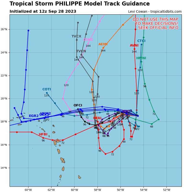
Woofde wrote:The 12z GFS keeps Philippe alive even past October 15th, taking it all the way to the canaries and then bouncing back to the open Atlantic. That would be quite crazy, though I doubt it comes to frutition.


22 day life span would put it on par with other long lived Atlantic systems.. rare, but not impossible at all.
0 likes   
My posts are my own personal opinion, defer to the National Hurricane Center (NHC) and other NOAA products for decision making during hurricane season.

User avatar
WalterWhite
Category 1
Category 1
Posts: 311
Joined: Fri Mar 17, 2023 5:53 pm

Re: ATL: PHILIPPE - Models

#50 Postby WalterWhite » Sat Sep 30, 2023 5:17 am

The HWRF, HMON, and HAFS-A take this to a 110-kt major hurricane.
0 likes   

User avatar
kevin
Category 5
Category 5
Posts: 1771
Age: 25
Joined: Wed Aug 28, 2019 4:35 am

Re: ATL: PHILIPPE - Models

#51 Postby kevin » Sat Sep 30, 2023 7:32 am

06z hurricane models overview. I didn't count sudden increases in wind for 1 frame (f.e. in HAFS-A at 42 hrs and HMON at 6 hrs) as a consistent upgrade in hurricane category. Clearly a big difference between HWRF/HMON and HAFS-A/HAFS-B.

HWRF
PEAK: 941 mb @ 111 hrs | 116 kt @ 102 hrs
hr / pressure (mb) / wind (kt)
00 / 1001 / 44
06 / 1003 / 41
12 / 1001 / 40
18 / 1003 / 49
24 / 998 / 46
30 / 998 / 51
36 / 990 / 52
42 / 985 / 66 - CAT 1
48 / 978 / 73
54 / 979 / 76
60 / 977 / 70
66 / 971 / 81
72 / 964 / 84 - CAT 2
78 / 959 / 101 - CAT 3
84 / 955 / 96
90 / 949 / 93
96 / 948 / 95
102 / 947 / 116 - CAT 4
108 / 944 / 112
114 / 942 / 110
120 / 944 / 108
126 / 949 / 104

HMON
PEAK: 933 mb @ 96 hrs | 116 kt @ 96 hrs
hr / pressure (mb) / wind (kt)
00 / 998 / 43
06 / 990 / 68
12 / 990 / 55
18 / 987 / 59
24 / 984 / 67 - CAT 1
30 / 982 / 70
36 / 975 / 75
42 / 974 / 78
48 / 975 / 69
54 / 976 / 73
60 / 971 / 82
66 / 963 / 93 - CAT 2
72 / 960 / 101 - CAT 3
78 / 953 / 105
84 / 943 / 116 - CAT 4
90 / 937 / 109
96 / 933 / 116
102 / 949 / 91
108 / 953 / 78
114 / 955 / 77
120 / 958 / 65
126 / 964 / 73

HAFS-A
PEAK: 954 mb @ 114 hrs | 108 kt @ 114 hrs
hr / pressure (mb) / wind (kt)
00 / 998 / 48
06 / 1003 / 38
12 / 1001 / 40
18 / 996 / 51
24 / 995 / 45
30 / 1001 / 45
36 / 994 / 55
42 / 988 / 77
48 / 997 / 46
54 / 995 / 61
60 / 994 / 56
66 / 993 / 49
72 / 993 / 52
78 / 990 / 59
84 / 986 / 63
90 / 980 / 69 - CAT 1
96 / 974 / 77
102 / 971 / 95 - CAT 2
108 / 958 / 107 - CAT 3
114 / 954 / 108
120 / 958 / 98
126 / 961 / 97

HAFS-B
PEAK: 908 mb @ 117 hrs | 153 kt @ 105 hrs
hr / pressure (mb) / wind (kt)
00 / 991 / 51
06 / 1003 / 38
12 / 1003 / 40
18 / 1002 / 40
24 / 1000 / 41
30 / 1001 / 38
36 / 998 / 40
42 / 999 / 45
48 / 999 / 44
54 / 1001 / 39
60 / 993 / 48
66 / 995 / 58
72 / 999 / 39
78 / 999 / 42
84 / 995 / 47
90 / 1000 / 49
96 / 1001 / 40
102 / 1003 / 34
108 / 994 / 55
114 / 1003 / 43
120 / 1000 / 41
126 / 1005 / 39
1 likes   

User avatar
Hurricane2022
Category 4
Category 4
Posts: 945
Joined: Tue Aug 23, 2022 11:38 pm
Location: Araçatuba, Brazil

Re: ATL: PHILIPPE - Models

#52 Postby Hurricane2022 » Sat Sep 30, 2023 9:36 am

HAFS-B :lol:
Image
Image
1 likes   
Sorry for the bad English sometimes...!
For reliable and detailed information for any meteorological phenomenon, please consult the National Hurricane Center, Joint Typhoon Warning Center , or your local Meteo Center.

--------

Una cvm Christo, pro Christo, et in Christo. Sit nomen Domini benedictvm.

User avatar
kevin
Category 5
Category 5
Posts: 1771
Age: 25
Joined: Wed Aug 28, 2019 4:35 am

Re: ATL: PHILIPPE - Models

#53 Postby kevin » Mon Oct 02, 2023 7:41 am

06z hurricane models overview. Only HWRF still shows a MH of these 4 models and the others barely show a cat 1.

HWRF
PEAK: 949 mb @ 108 hrs | 104 kt @ 96 hrs
hr / pressure (mb) / wind (kt)
00 / 997 / 44
06 / 991 / 63
12 / 993 / 63
18 / 991 / 63
24 / 991 / 55
30 / 994 / 50
36 / 991 / 50
42 / 988 / 59
48 / 986 / 55
54 / 983 / 60
60 / 977 / 63
66 / 977 / 56
72 / 972 / 72 - CAT 1
78 / 966 / 87 - CAT 2
84 / 960 / 99 - CAT 3
90 / 958 / 98
96 / 952 / 104
102 / 950 / 100
108 / 949 / 98
114 / 953 / 97
120 / 953 / 100
126 / 957 / 102

HMON
PEAK: 979 mb @ 102 hrs | 79 kt @ 126 hrs
hr / pressure (mb) / wind (kt)
00 / 998 / 46
06 / 998 / 46
12 / 989 / 58
18 / 994 / 56
24 / 992 / 61
30 / 994 / 51
36 / 994 / 55
42 / 994 / 50
48 / 995 / 43
54 / 989 / 65
60 / 992 / 52
66 / 995 / 51
72 / 994 / 57
78 / 993 / 58
84 / 994 / 56
90 / 990 / 53
96 / 987 / 62
102 / 979 / 67 - CAT 1
108 / 983 / 60
114 / 983 / 67
120 / 983 / 61
126 / 980 / 79

HAFS-A
PEAK: 985 mb @ 126 hrs | 68 kt @ 114 hrs
hr / pressure (mb) / wind (kt)
00 / 999 / 41
06 / 997 / 43
12 / 994 / 45
18 / 998 / 46
24 / 997 / 48
30 / 996 / 44
36 / 998 / 46
42 / 994 / 52
48 / 995 / 51
54 / 999 / 43
60 / 997 / 46
66 / 1000 / 50
72 / 997 / 46
78 / 993 / 48
84 / 994 / 45
90 / 992 / 51
96 / 991 / 56
102 / 993 / 58
108 / 992 / 55
114 / 990 / 68 - CAT 1
120 / 987 / 62
126 / 985 / 54

HAFS-B
PEAK: 981 mb @ 126 hrs | 70 kt @ 75 hrs
hr / pressure (mb) / wind (kt)
00 / 991 / 41
06 / 998 / 58
12 / 1001 / 51
18 / 998 / 47
24 / 995 / 48
30 / 1000 / 53
36 / 1001 / 46
42 / 1001 / 43
48 / 997 / 57
54 / 1002 / 37
60 / 1001 / 42
66 / 997 / 46
72 / 994 / 57
78 / 994 / 51
84 / 994 / 47
90 / 991 / 55
96 / 988 / 59
102 / 990 / 53
108 / 987 / 59
114 / 991 / 54
120 / 989 / 60
126 / 981 / 60
Last edited by kevin on Mon Oct 02, 2023 7:42 am, edited 1 time in total.
0 likes   

PavelGaborik10
Category 1
Category 1
Posts: 404
Joined: Tue Sep 04, 2018 3:23 pm

Re: ATL: PHILIPPE - Models

#54 Postby PavelGaborik10 » Mon Oct 02, 2023 7:41 am

Euro has been trying to left hook this thing into Atlantic Canada for a couple of days now.

My money is on a safe recurve.
0 likes   

PavelGaborik10
Category 1
Category 1
Posts: 404
Joined: Tue Sep 04, 2018 3:23 pm

Re: ATL: PHILIPPE - Models

#55 Postby PavelGaborik10 » Tue Oct 03, 2023 5:32 am

Looks like models are sending Philippe(or whatever remains of him) into the same area that was hit by Lee.

The positive news is they've trended weak and impacts would likely be equal, or likely even less than Lee, which didn't pack much of a punch at all.
1 likes   

User avatar
Hybridstorm_November2001
S2K Supporter
S2K Supporter
Posts: 2804
Joined: Sat Aug 21, 2004 2:50 pm
Location: SW New Brunswick, Canada
Contact:

Re: ATL: PHILIPPE - Models

#56 Postby Hybridstorm_November2001 » Tue Oct 03, 2023 9:41 pm

PavelGaborik10 wrote:Looks like models are sending Philippe(or whatever remains of him) into the same area that was hit by Lee.

The positive news is they've trended weak and impacts would likely be equal, or likely even less than Lee, which didn't pack much of a punch at all.


When I saw the models this morning I was literally "you've got to be kidding me!?". :eek: The track has shifted so dramatically since last Friday that it is unreal.
1 likes   

User avatar
Teban54
Category 5
Category 5
Posts: 1974
Joined: Sat May 19, 2018 1:19 pm

Re: ATL: PHILIPPE - Models

#57 Postby Teban54 » Wed Oct 04, 2023 1:29 am

FWIW, 0z HWRF still shows Philippe becoming a 65-70 kt Cat 1 when it's SE of Bermuda, but it's the only model that does so. HAFS-B shows 70 kt winds during extratropical transition.
0 likes   


Return to “2023”

Who is online

Users browsing this forum: No registered users and 15 guests