EPAC: JOVA - Post-Tropical - Discussion

Moderator: S2k Moderators

Message
Author
User avatar
Yellow Evan
Professional-Met
Professional-Met
Posts: 15959
Age: 25
Joined: Fri Jul 15, 2011 12:48 pm
Location: Henderson, Nevada/Honolulu, HI
Contact:

Re: EPAC: JOVA - Tropical Storm - Discussion

#41 Postby Yellow Evan » Tue Sep 05, 2023 7:52 pm

TXPZ27 KNES 060023
TCSENP

A. 11E (JOVA)

B. 06/0000Z

C. 13.2N

D. 109.0W

E. THREE/GOES-E

F. T3.5/3.5

G. IR/EIR/VIS

H. REMARKS...8/10 BANDING YIELDS A DT OF 3.5. THE MET IS 3.0 AND THE
PT IS 3.5. THE FT IS BASED ON THE DT.

I. ADDL POSITIONS

NIL


...BROWN
0 likes   

User avatar
Kingarabian
S2K Supporter
S2K Supporter
Posts: 15454
Joined: Sat Aug 08, 2009 3:06 am
Location: Honolulu, Hawaii

Re: EPAC: JOVA - Tropical Storm - Discussion

#42 Postby Kingarabian » Tue Sep 05, 2023 8:21 pm

Clearly a hurricane. An overachiever compared to the conservative global models.


Image
Image
1 likes   
RIP Kobe Bryant

zzzh
Category 2
Category 2
Posts: 553
Joined: Thu Sep 02, 2021 1:13 pm

Re: EPAC: JOVA - Tropical Storm - Discussion

#43 Postby zzzh » Tue Sep 05, 2023 8:23 pm

Image
1 likes   

User avatar
TorSkk
Category 2
Category 2
Posts: 514
Joined: Thu Jul 05, 2018 5:08 am

Re: EPAC: JOVA - Tropical Storm - Discussion

#44 Postby TorSkk » Tue Sep 05, 2023 9:03 pm


Such a stunning storm with its outflow
1 likes   

Sciencerocks
Category 5
Category 5
Posts: 7293
Age: 38
Joined: Thu Jul 06, 2017 1:51 am

Re: EPAC: JOVA - Tropical Storm - Discussion

#45 Postby Sciencerocks » Tue Sep 05, 2023 9:17 pm

Image
1 likes   

User avatar
cycloneye
Admin
Admin
Posts: 139488
Age: 67
Joined: Thu Oct 10, 2002 10:54 am
Location: San Juan, Puerto Rico

Re: EPAC: JOVA - Tropical Storm - Discussion

#46 Postby cycloneye » Tue Sep 05, 2023 9:59 pm

Tropical Storm Jova Discussion Number 6
NWS National Hurricane Center Miami FL EP112023
900 PM MDT Tue Sep 05 2023

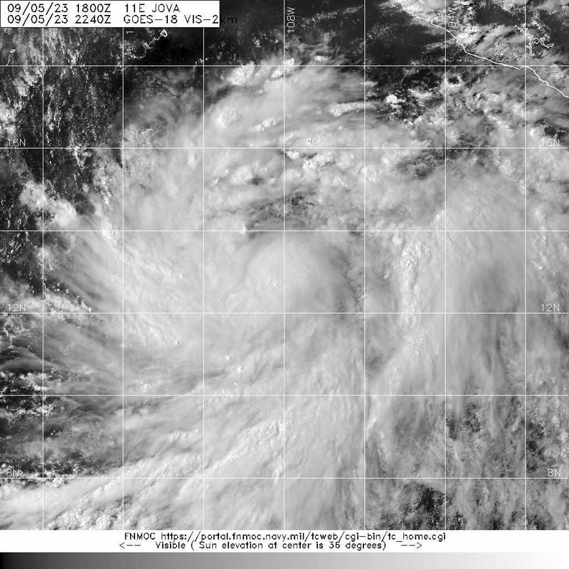
A new burst of deep convection has produced a nearly circular
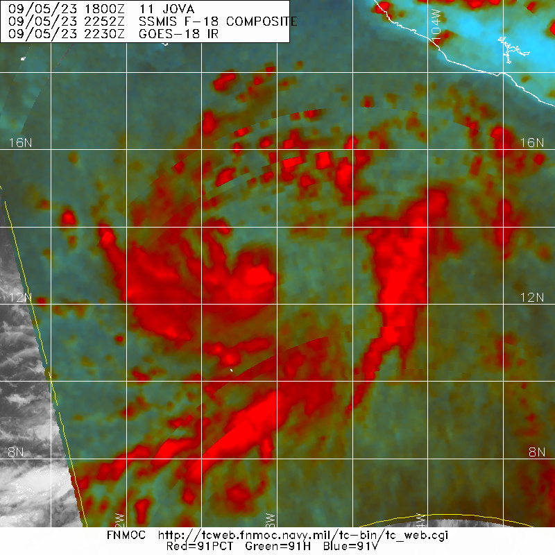
Central Dense Overcast over Jova's center, although a 0045 UTC
SSMIS microwave pass showed that the convection favors the
southwestern portion of the circulation due to moderate
northeasterly shear. Still, Dvorak estimates have increased to
T4.0/65 kt from TAFB and T3.5/55 kt from SAB, and the various
objective estimates have recently converged around 60 kt, which
will be the initial intensity. Jova's intensity has increased by
30 kt over the past 24 hours, and thus rapid intensification is
ongoing.

Jova is situated to the south of a mid-tropospheric ridge stretching
southwest of Mexico, and it continues to move toward the
west-northwest (290 degrees) at 8 kt. The track forecast, and the
forecast track, are both straightforward. Jova is expected to
maintain a west-northwestward motion around the southwestern
periphery of the ridge, but at a faster forward speed as the
distance between the two features decreases. No appreciable changes
were made from the previous NHC forecast except to show a slightly
faster motion, hedging toward the latest HCCA consensus solution.

The moderate shear over Jova is expected to abate during the next
6-12 hours. In addition, water temperatures are between 29-30
degrees Celsius, mid-level relative humidities are near 80 percent,
and upper-level divergence is forecast to be strong during the next
day or two. All of these ingredients point to a recipe for
continued rapid intensification, and many of the SHIPS-RII and DTOPS
thresholds suggest it is likely to persist for another 36 to 48
hours, with Jova reaching major hurricane strength. That said, the
regional hurricane models are much less enthusiastic about Jova's
continued strengthening and show peak intensities no more than 70-75
kt. Given the seemingly conducive environment, the NHC intensity
forecast continues to favor the stronger solutions, and peaks Jova
at category 4 intensity in 48 hours. Colder waters should induce
weakening by day 3, continuing through the end of the forecast
period.


FORECAST POSITIONS AND MAX WINDS

INIT 06/0300Z 13.2N 108.6W 60 KT 70 MPH
12H 06/1200Z 13.9N 110.0W 75 KT 85 MPH
24H 07/0000Z 14.8N 112.5W 90 KT 105 MPH
36H 07/1200Z 15.6N 115.0W 105 KT 120 MPH
48H 08/0000Z 16.8N 117.5W 115 KT 130 MPH
60H 08/1200Z 18.1N 120.0W 110 KT 125 MPH
72H 09/0000Z 19.4N 122.5W 100 KT 115 MPH
96H 10/0000Z 22.1N 127.0W 65 KT 75 MPH
120H 11/0000Z 24.2N 131.1W 50 KT 60 MPH

$$
Forecaster Berg
0 likes   
Visit the Caribbean-Central America Weather Thread where you can find at first post web cams,radars
and observations from Caribbean basin members Click Here

User avatar
Yellow Evan
Professional-Met
Professional-Met
Posts: 15959
Age: 25
Joined: Fri Jul 15, 2011 12:48 pm
Location: Henderson, Nevada/Honolulu, HI
Contact:

Re: EPAC: JOVA - Tropical Storm - Discussion

#47 Postby Yellow Evan » Tue Sep 05, 2023 10:09 pm

Image

Should take off once that rotates.
1 likes   

User avatar
Kingarabian
S2K Supporter
S2K Supporter
Posts: 15454
Joined: Sat Aug 08, 2009 3:06 am
Location: Honolulu, Hawaii

Re: EPAC: JOVA - Tropical Storm - Discussion

#48 Postby Kingarabian » Tue Sep 05, 2023 10:32 pm

Pre CPAC-2015 Jimena vibes. Just destined to become a major hurricane. Cat.5 is ceiling here.
0 likes   
RIP Kobe Bryant

User avatar
Kingarabian
S2K Supporter
S2K Supporter
Posts: 15454
Joined: Sat Aug 08, 2009 3:06 am
Location: Honolulu, Hawaii

Re: EPAC: JOVA - Tropical Storm - Discussion

#49 Postby Kingarabian » Tue Sep 05, 2023 10:38 pm

Image

Large system.
1 likes   
RIP Kobe Bryant

User avatar
Yellow Evan
Professional-Met
Professional-Met
Posts: 15959
Age: 25
Joined: Fri Jul 15, 2011 12:48 pm
Location: Henderson, Nevada/Honolulu, HI
Contact:

Re: EPAC: JOVA - Tropical Storm - Discussion

#50 Postby Yellow Evan » Tue Sep 05, 2023 11:34 pm

Image

Rotating now. Confident this is a hurricane now.
1 likes   

hurricanes1234
Category 5
Category 5
Posts: 2904
Joined: Sat Jul 28, 2012 6:19 pm
Location: Trinidad and Tobago

Re: EPAC: JOVA - Tropical Storm - Discussion

#51 Postby hurricanes1234 » Wed Sep 06, 2023 3:54 am

Stunningly cold cloudtops.

Image
2 likes   
PLEASE NOTE: With the exception of information from weather agencies that I may copy and paste here, my posts will NEVER be official, since I am NOT a meteorologist. They are solely my amateur opinion, and may or may not be accurate. Therefore, please DO NOT use them as official details, particularly when making important decisions. Thank you.

User avatar
cycloneye
Admin
Admin
Posts: 139488
Age: 67
Joined: Thu Oct 10, 2002 10:54 am
Location: San Juan, Puerto Rico

Re: EPAC: JOVA - Hurricane - Discussion

#52 Postby cycloneye » Wed Sep 06, 2023 4:01 am

Hurricane Jova Discussion Number 7
NWS National Hurricane Center Miami FL EP112023
300 AM MDT Wed Sep 06 2023

Jova continues to rapidly intensify. Infrared satellite imagery
shows that deep convection, with cloud tops colder than -90 degrees
C, has persisted over the estimated center overnight. Earlier
microwave imagery revealed a partial low- and mid-level eye-like
feature, still open to the north. Subjective and objective
satellite intensity estimates have risen since the last advisory and
the initial intensity is increased to 75 kt, in agreement with
the estimates from TAFB (T4.5/77 kt) and UW-CIMSS ADT (74 kt).

Environmental conditions seem to be quite conducive for
intensification and global model guidance suggests these conditions
will continue for the next couple of days. Deep-layer vertical wind
shear is expected to remain below 10 kt and sea surface temperatures
range between 28-29 degrees C along the forecast track. Statistical
models show extremely high probabilities of continued rapid
intensification and the official forecast explicitly predicts such
strengthening. The latest prediction now peaks Jova at 120 kt in 48
h. Cooling ocean waters and a dry, stable atmosphere should induce
a weakening trend by day 3, which is expected to continue through
the end of the forecast period.

Jova is moving west-northwestward at 8 kt. There have been no
changes to the track forecast reasoning. Jova is moving along the
southern periphery of a mid-level ridge centered over northern
Mexico. The hurricane is expected to maintain this motion with an
increase in forward speed as it rounds the southwestern edge of
the high. The latest NHC track forecast is quite similar to the
previous prediction, except for a slightly faster forward speed
favoring the corrected consensus aid, HCCA.


FORECAST POSITIONS AND MAX WINDS

INIT 06/0900Z 13.6N 109.6W 75 KT 85 MPH
12H 06/1800Z 14.3N 111.3W 90 KT 105 MPH
24H 07/0600Z 15.2N 113.8W 105 KT 120 MPH
36H 07/1800Z 16.2N 116.3W 115 KT 130 MPH
48H 08/0600Z 17.4N 118.8W 120 KT 140 MPH
60H 08/1800Z 18.6N 121.3W 110 KT 125 MPH
72H 09/0600Z 19.9N 123.8W 100 KT 115 MPH
96H 10/0600Z 22.4N 128.2W 65 KT 75 MPH
120H 11/0600Z 24.4N 131.5W 45 KT 50 MPH

$$
Forecaster Bucci
0 likes   
Visit the Caribbean-Central America Weather Thread where you can find at first post web cams,radars
and observations from Caribbean basin members Click Here

User avatar
Yellow Evan
Professional-Met
Professional-Met
Posts: 15959
Age: 25
Joined: Fri Jul 15, 2011 12:48 pm
Location: Henderson, Nevada/Honolulu, HI
Contact:

Re: EPAC: JOVA - Hurricane - Discussion

#53 Postby Yellow Evan » Wed Sep 06, 2023 6:46 am

Image

Image

Image

Major hurricane by tonight with that core and convective rotation.
3 likes   

User avatar
aspen
Category 5
Category 5
Posts: 8059
Joined: Sat Oct 12, 2019 7:10 pm
Location: Connecticut, USA

Re: EPAC: JOVA - Hurricane - Discussion

#54 Postby aspen » Wed Sep 06, 2023 7:32 am

2 likes   
Irene '11 Sandy '12 Hermine '16 5/15/2018 Derecho Fay '20 Isaias '20 Elsa '21 Henri '21 Ida '21

I am only a meteorology enthusiast who knows a decent amount about tropical cyclones. Look to the professional mets, the NHC, or your local weather office for the best information.

User avatar
Yellow Evan
Professional-Met
Professional-Met
Posts: 15959
Age: 25
Joined: Fri Jul 15, 2011 12:48 pm
Location: Henderson, Nevada/Honolulu, HI
Contact:

Re: EPAC: JOVA - Hurricane - Discussion

#55 Postby Yellow Evan » Wed Sep 06, 2023 7:49 am

Image

Category 5 here is possible tbh given how symmetrical it already is and how divergent the UL environment is. Band-centric structure could lead to early ERC onset, however.
2 likes   

User avatar
cycloneye
Admin
Admin
Posts: 139488
Age: 67
Joined: Thu Oct 10, 2002 10:54 am
Location: San Juan, Puerto Rico

Re: EPAC: JOVA - Hurricane - Discussion

#56 Postby cycloneye » Wed Sep 06, 2023 8:01 am

EP, 11, 2023090612, , BEST, 0, 139N, 1100W, 90, 972, HU
0 likes   
Visit the Caribbean-Central America Weather Thread where you can find at first post web cams,radars
and observations from Caribbean basin members Click Here

User avatar
cycloneye
Admin
Admin
Posts: 139488
Age: 67
Joined: Thu Oct 10, 2002 10:54 am
Location: San Juan, Puerto Rico

Re: EPAC: JOVA - Hurricane - Discussion

#57 Postby cycloneye » Wed Sep 06, 2023 8:11 am

1 likes   
Visit the Caribbean-Central America Weather Thread where you can find at first post web cams,radars
and observations from Caribbean basin members Click Here

SconnieCane
Category 4
Category 4
Posts: 913
Joined: Thu Aug 02, 2018 5:29 pm
Location: Madison, WI

Re: EPAC: JOVA - Hurricane - Discussion

#58 Postby SconnieCane » Wed Sep 06, 2023 8:29 am

Man. I was not expecting this thing to so dramatically outstrip Lee in the race for MH status. :eek:

Still think Lee ends up with a slightly stronger peak, but it may just come down to presence vs. lack of recon (assuming recon is timed well enough to catch Lee's peak, which I've learned is always in doubt more than we would all like).
0 likes   

User avatar
kevin
Category 5
Category 5
Posts: 1776
Age: 25
Joined: Wed Aug 28, 2019 4:35 am

Re: EPAC: JOVA - Hurricane - Discussion

#59 Postby kevin » Wed Sep 06, 2023 9:37 am

Image
5 likes   

User avatar
ElectricStorm
Category 5
Category 5
Posts: 4618
Age: 23
Joined: Tue Aug 13, 2019 11:23 pm
Location: Skiatook, OK / Norman, OK

Re: EPAC: JOVA - Hurricane - Discussion

#60 Postby ElectricStorm » Wed Sep 06, 2023 9:43 am

BULLETIN
Hurricane Jova Advisory Number 8
NWS National Hurricane Center Miami FL EP112023
900 AM MDT Wed Sep 06 2023

...JOVA CONTINUES TO RAPIDLY INTENSIFY...


SUMMARY OF 900 AM MDT...1500 UTC...INFORMATION
----------------------------------------------
LOCATION...14.2N 110.6W
ABOUT 600 MI...970 KM S OF THE SOUTHERN TIP OF BAJA CALIFORNIA
MAXIMUM SUSTAINED WINDS...105 MPH...165 KM/H
PRESENT MOVEMENT...WNW OR 295 DEGREES AT 13 MPH...20 KM/H
MINIMUM CENTRAL PRESSURE...972 MB...28.71 INCHES
0 likes   
I am in no way a professional. Take what I say with a grain of salt as I could be totally wrong. Please refer to the NHC, NWS, or SPC for official information.

Boomer Sooner!


Return to “2023”

Who is online

Users browsing this forum: No registered users and 7 guests