CPAC: CALVIN - Post-Tropical - Discussion
Moderator: S2k Moderators
-
HurricaneEnzo

- Category 2

- Posts: 724
- Joined: Wed Mar 14, 2018 12:18 pm
- Location: Newport, NC (Hurricane Alley)
Re: CPAC: CALVIN - Tropical Storm - Discussion
That's more like it. No matter how many times it happens it always impresses me how the Big Island absolutely shreds anything trying to move in from the East.
1 likes
Bertha 96' - Fran 96' - Bonnie 98' - Dennis 99' - Floyd 99' - Isabel 03' - Alex 04' - Ophelia 05' - Irene 11' - Arthur 14' - Matthew 16' - Florence 18' - Dorian 19' - Isaias 20' (countless other tropical storms and Hurricane swipes)
I am not a Professional Met just an enthusiast. Get your weather forecasts from the Pros!
I am not a Professional Met just an enthusiast. Get your weather forecasts from the Pros!
-
wxman57

- Moderator-Pro Met

- Posts: 22484
- Age: 66
- Joined: Sat Jun 21, 2003 8:06 pm
- Location: Houston, TX (southwest)
Re: CPAC: CALVIN - Tropical Storm - Discussion
HurricaneEnzo wrote:That's more like it. No matter how many times it happens it always impresses me how the Big Island absolutely shreds anything trying to move in from the East.
It wasn't the Big Island that shredded Calvin, it was a combination of wind shear and dry, sinking air. It's very hard to hit Hawaii from the east.
4 likes
-
Kingarabian

- S2K Supporter

- Posts: 15451
- Joined: Sat Aug 08, 2009 3:06 am
- Location: Honolulu, Hawaii
Re: CPAC: CALVIN - Tropical Storm - Discussion
wxman57 wrote:HurricaneEnzo wrote:That's more like it. No matter how many times it happens it always impresses me how the Big Island absolutely shreds anything trying to move in from the East.
It wasn't the Big Island that shredded Calvin, it was a combination of wind shear and dry, sinking air. It's very hard to hit Hawaii from the east.
It is, but the amount of attempts from the east have substantially increased over the past 9 years.
1 likes
RIP Kobe Bryant
-
wxman57
- Moderator-Pro Met
- Posts: 22484
- Age: 66
- Joined: Sat Jun 21, 2003 8:06 pm
- Location: Houston, TX (southwest)
Re: CPAC: CALVIN - Tropical Storm - Discussion
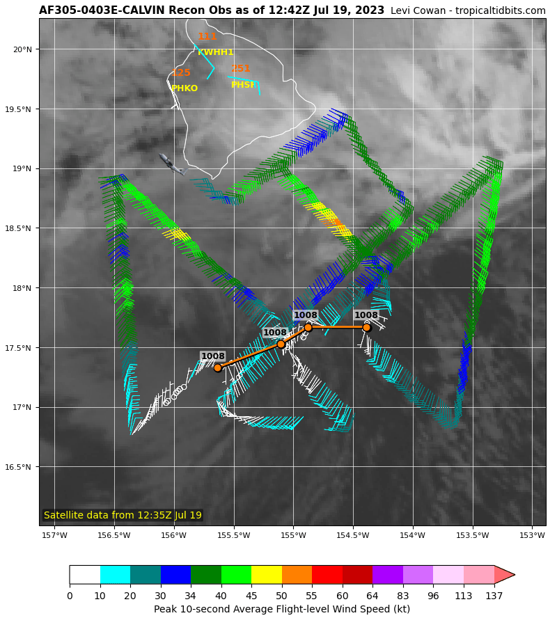
What will CPHC do with Calvin in their next advisory? Recon clearly found an open wave with wind 30 kts or less. How can Calvin be a 45 kt TS? I think that Calvin was opening up into a wave late yesterday afternoon when it appeared to decouple. I've noticed that the NHC and CPHC typically do not like to indicate a storm is weakening as it nears land. Their main job is public safety, so they use an abundance (over abundance?) of caution in situations like this. I'm not faulting them with Calvin. What if Calvin's squalls suddenly returned as the center passed to the south overnight? They're in a tough spot with Calvin. However, our clients want to know what they should really expect when Calvin passes. For days, we've told our clients that Calvin would weaken to a remnant low, an open wave as it passed Hawaii.
3 likes
-
wxman57
- Moderator-Pro Met
- Posts: 22484
- Age: 66
- Joined: Sat Jun 21, 2003 8:06 pm
- Location: Houston, TX (southwest)
Re: CPAC: CALVIN - Tropical Storm - Discussion
Interesting that CPHC mentions everything BUT SFMR observations for estimating Calvin's intensity. Why only consider FL wind and Dvorak estimates and not SFMR? You do not use a random FL wind outside of convection and reduce it to the surface when you have actual wind measurements in the area showing 30 kts or less. What about the lack of a closed circulation? I know, they don't want people to relax - just in case. It's frustrating when I have to keep Calvin a TS on our 18Z advisory only because CPHC refuses to acknowledge its true status. Hilo winds remain easterly at 8 kts. Total rainfall appears to be 2.44".
Deep convection around Calvin collapsed overnight, leaving residual
deep convection across east and southeast-facing shores and
slopes of the Big Island and Maui. This is the result of deep
tropical flow interacting with terrain. Calvin's low level
circulation center (LLCC) has become completely exposed, allowing
small corrections in initial position and movement for this
advisory. Instruments aboard the US Air Force Reserve's Hurricane
Hunter aircraft showed maximum flight level winds of 47 kt, reduced
to about 42 kt at sea level. Subjective Dvorak satellite analyses
from PHFO and JTWC gave current intensity numbers of 2.5, 35 kt and
2.0, 30 kt, respectively. UW-CIMSS derived an ADT intensity of
37 kt, while an ASCAT pass from last evening showed maximum winds
of about 40 kt within Calvin's northeast quadrant. Based on these
data, the initial intensity for this advisory has been decreased to
40 kt.
3 likes
-
cycloneye

- Admin

- Posts: 139327
- Age: 67
- Joined: Thu Oct 10, 2002 10:54 am
- Location: San Juan, Puerto Rico
Re: CPAC: CALVIN - Tropical Storm - Discussion
Tropical Storm Calvin Discussion Number 32
NWS Central Pacific Hurricane Center Honolulu HI EP032023
500 AM HST Wed Jul 19 2023
Deep convection around Calvin collapsed overnight, leaving residual
deep convection across east and southeast-facing shores and
slopes of the Big Island and Maui. This is the result of deep
tropical flow interacting with terrain. Calvin's low level
circulation center (LLCC) has become completely exposed, allowing
small corrections in initial position and movement for this
advisory. Instruments aboard the US Air Force Reserve's Hurricane
Hunter aircraft showed maximum flight level winds of 47 kt, reduced
to about 42 kt at sea level. Subjective Dvorak satellite analyses
from PHFO and JTWC gave current intensity numbers of 2.5, 35 kt and
2.0, 30 kt, respectively. UW-CIMSS derived an ADT intensity of
37 kt, while an ASCAT pass from last evening showed maximum winds
of about 40 kt within Calvin's northeast quadrant. Based on these
data, the initial intensity for this advisory has been decreased to
40 kt.
The initial motion for this advisory is unchanged at 275/17 kt as
Calvin continues to move south of a large subtropical ridge. No
significant change in this steering is expected over the next
several days. Calvin is about to complete its passage south of the
Big Island and the forecast track is essentially the same as the
previous forecast track, aside from small changes in initial
position and forward speed from tau 12 and beyond. The total track
is shorter as this system is forecast to dissipate at tau 60. The
forecast track remains within, but on the southern side, of the
guidance envelope. Although the center of Calvin is passing south of
the Big Island, much of the island remains within the 34 kt radius,
and impacts from strong winds, heavy rainfall, and high surf are
occurring.
The forecast calls for Calvin to finish its passage south of the
Big Island this morning, then continue moving westward away from
the main island chain as a weakening tropical storm. Vertical shear
affecting the tropical cyclone is expected to be moderate today,
then strong by tonight. The strong shear should result in
weakening to post-tropical/remnant low status late Thursday night.
KEY MESSAGES:
1. Calvin has almost completed its passage south of Hawaii County.
Expect periods of flash flooding, dangerous surf and damaging
winds. Calvin will continue to weaken as it moves westward to the
south of the other Hawaiian Islands today and tonight, bringing the
potential for some peripheral impacts.
FORECAST POSITIONS AND MAX WINDS
INIT 19/1500Z 17.8N 156.8W 40 KT 45 MPH
12H 20/0000Z 17.9N 159.5W 35 KT 40 MPH
24H 20/1200Z 18.1N 163.1W 35 KT 40 MPH
36H 21/0000Z 18.2N 166.8W 30 KT 35 MPH
48H 21/1200Z 18.2N 170.7W 25 KT 30 MPH...POST-TROP/REMNT LOW
60H 22/0000Z...DISSIPATED
$$
Forecaster Powell
0 likes
Visit the Caribbean-Central America Weather Thread where you can find at first post web cams,radars
and observations from Caribbean basin members Click Here
and observations from Caribbean basin members Click Here
-
Kingarabian
- S2K Supporter
- Posts: 15451
- Joined: Sat Aug 08, 2009 3:06 am
- Location: Honolulu, Hawaii
Re: CPAC: CALVIN - Tropical Storm - Discussion
wxman57 wrote:Interesting that CPHC mentions everything BUT SFMR observations for estimating Calvin's intensity. Why only consider FL wind and Dvorak estimates and not SFMR? You do not use a random FL wind outside of convection and reduce it to the surface when you have actual wind measurements in the area showing 30 kts or less. What about the lack of a closed circulation? I know, they don't want people to relax - just in case. It's frustrating when I have to keep Calvin a TS on our 18Z advisory only because CPHC refuses to acknowledge its true status. Hilo winds remain easterly at 8 kts. Total rainfall appears to be 2.44".
Deep convection around Calvin collapsed overnight, leaving residual
deep convection across east and southeast-facing shores and
slopes of the Big Island and Maui. This is the result of deep
tropical flow interacting with terrain. Calvin's low level
circulation center (LLCC) has become completely exposed, allowing
small corrections in initial position and movement for this
advisory. Instruments aboard the US Air Force Reserve's Hurricane
Hunter aircraft showed maximum flight level winds of 47 kt, reduced
to about 42 kt at sea level. Subjective Dvorak satellite analyses
from PHFO and JTWC gave current intensity numbers of 2.5, 35 kt and
2.0, 30 kt, respectively. UW-CIMSS derived an ADT intensity of
37 kt, while an ASCAT pass from last evening showed maximum winds
of about 40 kt within Calvin's northeast quadrant. Based on these
data, the initial intensity for this advisory has been decreased to
40 kt.
One of them will be on here soon to explain lol
0 likes
RIP Kobe Bryant
-
Sciencerocks
- Category 5

- Posts: 7287
- Age: 38
- Joined: Thu Jul 06, 2017 1:51 am

-
Yellow Evan

- Professional-Met

- Posts: 15956
- Age: 25
- Joined: Fri Jul 15, 2011 12:48 pm
- Location: Henderson, Nevada/Honolulu, HI
- Contact:
Re: CPAC: CALVIN - Tropical Storm - Discussion
ASCAT is probably enough to justify keeping Calvin at 40 knots. Orographic lifting is helping Calvin maintain deep convection for now but the end is near.
0 likes
-
wxman57
- Moderator-Pro Met
- Posts: 22484
- Age: 66
- Joined: Sat Jun 21, 2003 8:06 pm
- Location: Houston, TX (southwest)
Re: CPAC: CALVIN - Tropical Storm - Discussion
Yellow Evan wrote:ASCAT is probably enough to justify keeping Calvin at 40 knots. Orographic lifting is helping Calvin maintain deep convection for now but the end is near.
You don't use an ASCAT pass from 12 hours ago to estimate current intensity when you have actual reconnaissance in there.
3 likes
-
cycloneye
- Admin
- Posts: 139327
- Age: 67
- Joined: Thu Oct 10, 2002 10:54 am
- Location: San Juan, Puerto Rico
Re: CPAC: CALVIN - Post-Tropical - Discussion
Post-Tropical Cyclone Calvin Discussion Number 33
NWS Central Pacific Hurricane Center Honolulu HI EP032023
1100 AM HST Wed Jul 19 2023
Visible satellite imagery shows that Calvin's fully exposed low-
level center is becoming increasingly broad and ill-defined.
Subjective Dvorak fixes indicate that Calvin is too weak to
classify, and central convection has been absent for sufficiently
long that Calvin can safely be deemed post-tropical. Gale force
winds continue in the northern semicircle for now, but increased
vertical wind shear along the forecast track will prevent Calvin
from redeveloping. The updated forecast track lies close to the
well-performing HCCA and ECMWF guidance, with dissipation expected
in about 36 hours as the environment becomes increasingly hostile.
This is the last advisory issued by the Central Pacific Hurricane
Center on this system. Additional information on this system can be
found in High Seas Forecasts issued by the National Weather Service
in Honolulu, under AWIPS header HFOHSFNP, WMO header FZPN40 PHFO,
and online at weather.gov/hfo/HSFNP.
FORECAST POSITIONS AND MAX WINDS
INIT 19/2100Z 17.9N 158.5W 35 KT 40 MPH...POST-TROPICAL
12H 20/0600Z 18.2N 161.3W 30 KT 35 MPH...POST-TROP/REMNT LOW
24H 20/1800Z 18.5N 165.0W 30 KT 35 MPH...POST-TROP/REMNT LOW
36H 21/0600Z...DISSIPATED
$$
Forecaster Birchard
1 likes
Visit the Caribbean-Central America Weather Thread where you can find at first post web cams,radars
and observations from Caribbean basin members Click Here
and observations from Caribbean basin members Click Here
-
Iceresistance

- Category 5
- Posts: 8925
- Age: 20
- Joined: Sat Oct 10, 2020 9:45 am
- Location: Tecumseh, OK/Norman, OK
Re: CPAC: CALVIN - Post-Tropical - Discussion
0 likes
Bill 2015 & Beta 2020
Winter 2020-2021
All observations are in Tecumseh, OK unless otherwise noted.
Winter posts are focused mainly for Oklahoma & Texas.
Take any of my forecasts with a grain of salt, refer to the NWS, SPC, and NHC for official information
Never say Never with weather! Because ANYTHING is possible!
Winter 2020-2021
All observations are in Tecumseh, OK unless otherwise noted.
Winter posts are focused mainly for Oklahoma & Texas.
Take any of my forecasts with a grain of salt, refer to the NWS, SPC, and NHC for official information
Never say Never with weather! Because ANYTHING is possible!
Who is online
Users browsing this forum: No registered users and 21 guests