EPAC: JOVA - Post-Tropical - Discussion

Moderator: S2k Moderators

Message
Author
User avatar
cycloneye
Admin
Admin
Posts: 139344
Age: 67
Joined: Thu Oct 10, 2002 10:54 am
Location: San Juan, Puerto Rico

Re: EPAC: ELEVEN-E - Tropical Depression - Discussion

#21 Postby cycloneye » Mon Sep 04, 2023 9:36 pm

Tropical Depression Eleven-E Discussion Number 2
NWS National Hurricane Center Miami FL EP112023
1000 PM CDT Mon Sep 04 2023

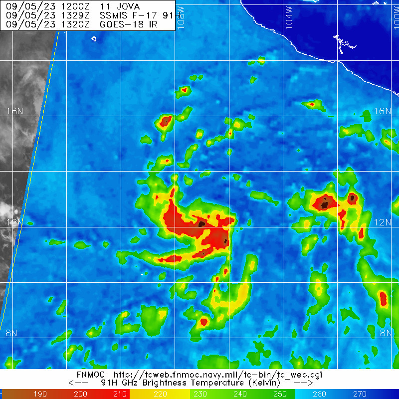
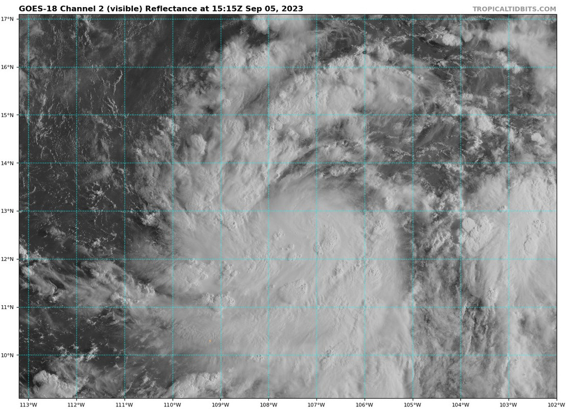
Microwave data and visible satellite imagery indicate the depression
is producing small curved bands of convection tonight. More of the
convective activity is occurring over the western portion of the
circulation, likely due to modest easterly shear over the system.
The bands are still somewhat fragmented, and the latest Dvorak
classifications are T2.0/30 kt from SAB and T2.5/35 kt from TAFB.
The initial intensity is held at 30 kt for this advisory, with
scatterometer data later tonight hopefully providing more clarity on
the system's location and intensity.

The somewhat uncertain initial motion is westward (280/10 kt) as the
cyclone is steered by a high pressure ridge to its north. This
ridge, which extends westward from the southwestern U.S. across
northern Mexico to the eastern Pacific, should remain the dominant
steering feature during the next several days. The various track
models generally agree on a west-northwestward motion through this
week, although there are speed differences noted during the first
few days of the forecast period, with the ECMWF faster than the GFS.
The updated NHC forecast is somewhat faster than the previous
prediction at most forecast times, and it generally lies between the
simple consensus (TVCN) and HFIP corrected consensus (HCCA) aids.

Environmental and oceanic conditions appear favorable for some
significant intensification of the cyclone later this week. In the
near term, modest strengthening is forecast while the cyclone
becomes better organized and solidifies an inner core. Once this
occurs, the system should be primed to take advantage of conducive
conditions for strengthening. The deep-layer shear is forecast to be
fairly low for the next several days, and the cyclone is forecast to
move within a very moist and diffluent upper-level environment over
very warm SSTs during the next 72-96 h. The rapid intensification
(RI) indices, notably the SHIPS-RII and DTOPS, show a well above
average (60 to 70 percent) chance of a 65-kt intensity increase
during the next 72 h. Therefore, the NHC intensity forecast
continues to explicitly show RI midweek, and the system is
predicted to peak at major hurricane strength. This forecast lies
between the IVCN/HCCA aids and the higher statistical-dynamical
guidance SHIPS and LGEM. By days 4-5, some weakening is expected
while the system moves over progressively cooler waters.


FORECAST POSITIONS AND MAX WINDS

INIT 05/0300Z 12.7N 105.6W 30 KT 35 MPH
12H 05/1200Z 13.0N 106.3W 35 KT 40 MPH
24H 06/0000Z 13.6N 107.9W 45 KT 50 MPH
36H 06/1200Z 14.3N 110.0W 55 KT 65 MPH
48H 07/0000Z 15.1N 112.4W 65 KT 75 MPH
60H 07/1200Z 16.1N 114.8W 85 KT 100 MPH
72H 08/0000Z 17.4N 117.1W 100 KT 115 MPH
96H 09/0000Z 20.0N 122.0W 90 KT 105 MPH
120H 10/0000Z 22.5N 126.0W 65 KT 75 MPH

$$
Forecaster Reinhart
0 likes   
Visit the Caribbean-Central America Weather Thread where you can find at first post web cams,radars
and observations from Caribbean basin members Click Here

User avatar
Yellow Evan
Professional-Met
Professional-Met
Posts: 15956
Age: 25
Joined: Fri Jul 15, 2011 12:48 pm
Location: Henderson, Nevada/Honolulu, HI
Contact:

Re: EPAC: ELEVEN-E - Tropical Depression - Discussion

#22 Postby Yellow Evan » Mon Sep 04, 2023 9:58 pm

Image

Continuing the trend recently of developing way faster than guidance indicates.
2 likes   

User avatar
Extratropical94
Professional-Met
Professional-Met
Posts: 3535
Age: 29
Joined: Wed Oct 20, 2010 6:36 am
Location: Hamburg, Germany
Contact:

Re: EPAC: ELEVEN-E - Tropical Depression - Discussion

#23 Postby Extratropical94 » Tue Sep 05, 2023 1:57 am

Should become TS Jova soon
EP, 11, 2023090506, , BEST, 0, 127N, 1063W, 35, 1004, TS
0 likes   
54° 11' 59'' N, 9° 9' 20'' E
Boomer Sooner!
Go Broncos! Go Cards! Go Niners!
- Daniel

User avatar
HurricaneEnzo
Category 2
Category 2
Posts: 724
Joined: Wed Mar 14, 2018 12:18 pm
Location: Newport, NC (Hurricane Alley)

Re: EPAC: JOVA - Tropical Storm - Discussion

#24 Postby HurricaneEnzo » Tue Sep 05, 2023 6:44 am

While the EPAC has featured more quality it is still pretty crazy to me the ATL has had more named systems to this point during a NINO. I guess the record warmth and the fact this Nino hasn't exactly been typical (no prolonged WWB, SOI not that negative) has allowed the ATL to produce.
0 likes   
Bertha 96' - Fran 96' - Bonnie 98' - Dennis 99' - Floyd 99' - Isabel 03' - Alex 04' - Ophelia 05' - Irene 11' - Arthur 14' - Matthew 16' - Florence 18' - Dorian 19' - Isaias 20' (countless other tropical storms and Hurricane swipes)

I am not a Professional Met just an enthusiast. Get your weather forecasts from the Pros!

User avatar
Yellow Evan
Professional-Met
Professional-Met
Posts: 15956
Age: 25
Joined: Fri Jul 15, 2011 12:48 pm
Location: Henderson, Nevada/Honolulu, HI
Contact:

Re: EPAC: JOVA - Tropical Storm - Discussion

#25 Postby Yellow Evan » Tue Sep 05, 2023 7:46 am

Image

Hurricane soon tbh.
2 likes   

User avatar
Yellow Evan
Professional-Met
Professional-Met
Posts: 15956
Age: 25
Joined: Fri Jul 15, 2011 12:48 pm
Location: Henderson, Nevada/Honolulu, HI
Contact:

Re: EPAC: JOVA - Tropical Storm - Discussion

#26 Postby Yellow Evan » Tue Sep 05, 2023 7:49 am

EP, 11, 2023090512, , BEST, 0, 130N, 1071W, 45, 1001, TS, 34, NEQ, 50, 40, 0, 0, 1009, 150, 50, 0, 0, E, 0, , 0, 0, JOVA, M, 0, , 0, 0, 0, 0, genesis-num, 018,
1 likes   

User avatar
Kingarabian
S2K Supporter
S2K Supporter
Posts: 15451
Joined: Sat Aug 08, 2009 3:06 am
Location: Honolulu, Hawaii

Re: EPAC: JOVA - Tropical Storm - Discussion

#27 Postby Kingarabian » Tue Sep 05, 2023 8:22 am

I would go 60kts with that look.
0 likes   
RIP Kobe Bryant

Sciencerocks
Category 5
Category 5
Posts: 7287
Age: 38
Joined: Thu Jul 06, 2017 1:51 am

Re: EPAC: JOVA - Tropical Storm - Discussion

#28 Postby Sciencerocks » Tue Sep 05, 2023 9:13 am

Image
1 likes   

User avatar
cycloneye
Admin
Admin
Posts: 139344
Age: 67
Joined: Thu Oct 10, 2002 10:54 am
Location: San Juan, Puerto Rico

Re: EPAC: JOVA - Tropical Storm - Discussion

#29 Postby cycloneye » Tue Sep 05, 2023 10:21 am

Tropical Storm Jova Discussion Number 4
NWS National Hurricane Center Miami FL EP112023
900 AM MDT Tue Sep 05 2023

Tropical Storm Jova continues to become better organized this
morning, with deep convection increasing near the low-level center.
Earlier AMSR microwave imagery showed a mid-level core developing,
with a sharp curved band on the southern side of system. Subjective
Dvorak estimates from TAFB and objective ADT intensity estimates
from UW-CIMMS have increased for this advisory to T3.5/45 kt. Given
the improved structure and satellite estimates, the intensity for
this advisory has increased to 45 kt.

The initial motion is westward or 280/9 kt. Jova is forecast to
continue on a general west to west-northwest motion the next
several days along the southern side of a ridge extending westward
over the southwestern United States. The track guidance is in
fairly good agreement, with the main difference being the forward
speed of Jova in the short-term. The NHC forecast is close to the
previous advisory, and lies near the corrected consensus aids.

Jova is in a favorable environment to continue strengthening with
relatively low vertical wind shear, warm sea surface temperatures
and moist mid-level RH values. The various model Rapid
Intensification (RI) indices are all well above normal. The
intensity forecast calls for rapid intensification, with Jova
becoming a hurricane on Wednesday. The intensity forecast lies at
the higher end of the guidance envelope given the favorable
parameters for RI, closest to the SHIPS guidance. Later in the
forecast period, the system is forecast to move over a sharp SST
gradient with much cooler ocean temperatures inducing a weakening
trend.


FORECAST POSITIONS AND MAX WINDS

INIT 05/1500Z 13.1N 107.4W 45 KT 50 MPH
12H 06/0000Z 13.4N 108.5W 60 KT 70 MPH
24H 06/1200Z 14.1N 110.3W 75 KT 85 MPH
36H 07/0000Z 15.1N 112.8W 85 KT 100 MPH
48H 07/1200Z 16.2N 115.2W 95 KT 110 MPH
60H 08/0000Z 17.5N 117.5W 105 KT 120 MPH
72H 08/1200Z 18.7N 120.0W 105 KT 120 MPH
96H 09/1200Z 21.3N 124.8W 85 KT 100 MPH
120H 10/1200Z 23.6N 129.4W 65 KT 75 MPH

$$
Forecaster Kelly/Blake
0 likes   
Visit the Caribbean-Central America Weather Thread where you can find at first post web cams,radars
and observations from Caribbean basin members Click Here

User avatar
Kingarabian
S2K Supporter
S2K Supporter
Posts: 15451
Joined: Sat Aug 08, 2009 3:06 am
Location: Honolulu, Hawaii

Re: EPAC: JOVA - Tropical Storm - Discussion

#30 Postby Kingarabian » Tue Sep 05, 2023 10:30 am

No clear cut eyewall forming on MW imagery yet. But it does have that look to it.

Image

Image
1 likes   
RIP Kobe Bryant

Sciencerocks
Category 5
Category 5
Posts: 7287
Age: 38
Joined: Thu Jul 06, 2017 1:51 am

Re: EPAC: JOVA - Tropical Storm - Discussion

#31 Postby Sciencerocks » Tue Sep 05, 2023 10:45 am

Image
1 likes   

User avatar
Yellow Evan
Professional-Met
Professional-Met
Posts: 15956
Age: 25
Joined: Fri Jul 15, 2011 12:48 pm
Location: Henderson, Nevada/Honolulu, HI
Contact:

Re: EPAC: JOVA - Tropical Storm - Discussion

#32 Postby Yellow Evan » Tue Sep 05, 2023 1:50 pm

TXPZ27 KNES 051815
TCSENP

A. 11E (JOVA)

B. 05/1800Z

C. 12.6N

D. 108.0W

E. THREE/HIMAWARI-9

F. T3.0/3.0

G. IR/EIR/VIS

H. REMARKS...6/10 BANDING RESULTS IN A DT OF 3.0. MET IS 2.5 AND PT IS
3.0. THE FT IS BASED ON THE DT.

I. ADDL POSITIONS

NIL


...ZHU
0 likes   

Sciencerocks
Category 5
Category 5
Posts: 7287
Age: 38
Joined: Thu Jul 06, 2017 1:51 am

Re: EPAC: JOVA - Tropical Storm - Discussion

#33 Postby Sciencerocks » Tue Sep 05, 2023 2:13 pm

Image
1 likes   

User avatar
galaxy401
Category 5
Category 5
Posts: 2299
Age: 29
Joined: Sat Aug 25, 2012 9:04 pm
Location: Casa Grande, Arizona

Re: EPAC: JOVA - Tropical Storm - Discussion

#34 Postby galaxy401 » Tue Sep 05, 2023 3:57 pm

Now forecast to reach Cat 4 just like Lee. Very rare do you see the NHC have two Cat 4 forecasts from tropical storms.

Tropical Storm Jova Discussion Number 5
NWS National Hurricane Center Miami FL EP112023
300 PM MDT Tue Sep 05 2023

Jova continues to look better organized on visible and infrared
satellite imagery, with sharp curved banding on the south side of
the system wrapping into the center. Deep convection has continued
over the center with cold cloud tops near -80C. ASCAT and GMI
microwave instruments both sampled Jova this afternoon, and
indicated that the low-level center has redeveloped farther south
than indicated in the previous advisory, under the burst of deep
convection. The GMI 89-GHz microwave imagery depicted a mid-level
eye-wall feature starting to develop. Dvorak estimates from TAFB and
SAB were at T3.5 and T3.0, respectively, with this advisory, and
objective ADT estimates were around 50 kt. Given the mid-level
feature depicted on microwave imagery and the improved structure,
the initial intensity leans toward the higher satellite estimates at
55kt.

The initial motion is a little uncertain given the relocation of the
low-level center, but an average motion is west-northwestward around
8 kt. Jova is forecast to continue on a general west-northwest
motion the next several days along the southern side of a ridge
extending westward over the southwestern United States. The track
guidance is in fairly good agreement, with the main differences
being on the forward speed of Jova in the short term. The NHC
forecast is shifted slightly south of the previous one, given the
re-formation of the center southward, and lies near the consensus
aids.

Jova is in a favorable environment to rapidly intensify, with
relatively low vertical wind shear, warm sea surface temperatures
and moist mid-level RH values. The various model Rapid
Intensification (RI) indices are quite high compared to the
climatological mean, and the NHC forecast depicts rapid
intensification. Jova is forecast to strengthen into a hurricane on
Wednesday and into a major hurricane in about 36-48 h. The intensity
forecast lies at the higher end of the guidance envelope given the
favorable parameters and above climatological mean for RI, closest
to the SHIPS guidance. Later in the forecast period, the system is
forecast to move over a sharp SST gradient with much cooler ocean
temperatures inducing a weakening trend.


FORECAST POSITIONS AND MAX WINDS

INIT 05/2100Z 12.9N 108.3W 55 KT 65 MPH
12H 06/0600Z 13.3N 109.4W 70 KT 80 MPH
24H 06/1800Z 14.3N 111.6W 85 KT 100 MPH
36H 07/0600Z 15.1N 114.0W 100 KT 115 MPH
48H 07/1800Z 16.2N 116.5W 110 KT 125 MPH
60H 08/0600Z 17.3N 118.9W 115 KT 130 MPH
72H 08/1800Z 18.8N 121.4W 105 KT 120 MPH
96H 09/1800Z 21.5N 126.3W 75 KT 85 MPH
120H 10/1800Z 23.5N 130.7W 60 KT 70 MPH

$$
Forecaster Kelly/Blake
0 likes   
Got my eyes on moving right into Hurricane Alley: Florida.

User avatar
Yellow Evan
Professional-Met
Professional-Met
Posts: 15956
Age: 25
Joined: Fri Jul 15, 2011 12:48 pm
Location: Henderson, Nevada/Honolulu, HI
Contact:

Re: EPAC: JOVA - Tropical Storm - Discussion

#35 Postby Yellow Evan » Tue Sep 05, 2023 5:29 pm

Image

Curling upshear - hurricane soon.
1 likes   

underthwx
Category 5
Category 5
Posts: 1929
Joined: Sat Jul 30, 2011 2:14 pm
Location: Brazoria County Texas

Re: EPAC: JOVA - Tropical Storm - Discussion

#36 Postby underthwx » Tue Sep 05, 2023 5:34 pm


Maybe Jova will surpass Lee?...sure does look impressive
0 likes   

User avatar
DioBrando
Category 4
Category 4
Posts: 917
Age: 27
Joined: Sun Aug 12, 2018 12:45 pm

Re: EPAC: JOVA - Tropical Storm - Discussion

#37 Postby DioBrando » Tue Sep 05, 2023 5:36 pm

underthwx wrote:

Maybe Jova will surpass Lee?...sure does look impressive

orly? cmon man Jova won't be stronger than Lee
2 likes   
blonde stacey (xe/xem/xir)

Sciencerocks
Category 5
Category 5
Posts: 7287
Age: 38
Joined: Thu Jul 06, 2017 1:51 am

Re: EPAC: JOVA - Tropical Storm - Discussion

#38 Postby Sciencerocks » Tue Sep 05, 2023 6:40 pm

Image
3 likes   

User avatar
Yellow Evan
Professional-Met
Professional-Met
Posts: 15956
Age: 25
Joined: Fri Jul 15, 2011 12:48 pm
Location: Henderson, Nevada/Honolulu, HI
Contact:

Re: EPAC: JOVA - Tropical Storm - Discussion

#39 Postby Yellow Evan » Tue Sep 05, 2023 7:13 pm

underthwx wrote:

Maybe Jova will surpass Lee?...sure does look impressive


Lee will have Recon so will probably officially be stronger.
1 likes   

User avatar
cycloneye
Admin
Admin
Posts: 139344
Age: 67
Joined: Thu Oct 10, 2002 10:54 am
Location: San Juan, Puerto Rico

Re: EPAC: JOVA - Tropical Storm - Discussion

#40 Postby cycloneye » Tue Sep 05, 2023 7:41 pm

EP, 11, 2023090600, , BEST, 0, 130N, 1082W, 60, 993, TS
0 likes   
Visit the Caribbean-Central America Weather Thread where you can find at first post web cams,radars
and observations from Caribbean basin members Click Here


Return to “2023”

Who is online

Users browsing this forum: No registered users and 9 guests