WPAC: SAOLA - Post-Tropical
Moderator: S2k Moderators
-
mrbagyo

- Category 5

- Posts: 3615
- Age: 32
- Joined: Thu Apr 12, 2012 9:18 am
- Location: 14.13N 120.98E
- Contact:
Re: WPAC: SAOLA - Typhoon
Oil platform Lufeng 13-2 reportedly recorded a station pressure of 943.9hPa at 9:30 AM (alt. 59.5 masl) while about 22 kms away from the center of Typhoon Saola.
0 likes
The posts in this forum are NOT official forecast and should not be used as such. They are just the opinion of the poster and may or may not be backed by sound meteorological data. They are NOT endorsed by any professional institution or storm2k.org. For official information, please refer to RSMC, NHC and NWS products.
-
Sciencerocks
- Category 5
- Posts: 7287
- Age: 38
- Joined: Thu Jul 06, 2017 1:51 am
-
doomhaMwx

- Category 5
- Posts: 2398
- Age: 25
- Joined: Tue Apr 18, 2017 4:01 am
- Location: Baguio/Benguet, Philippines
- Contact:
Re: WPAC: SAOLA - Typhoon
Photos of the eye from today's HKO recon mission.
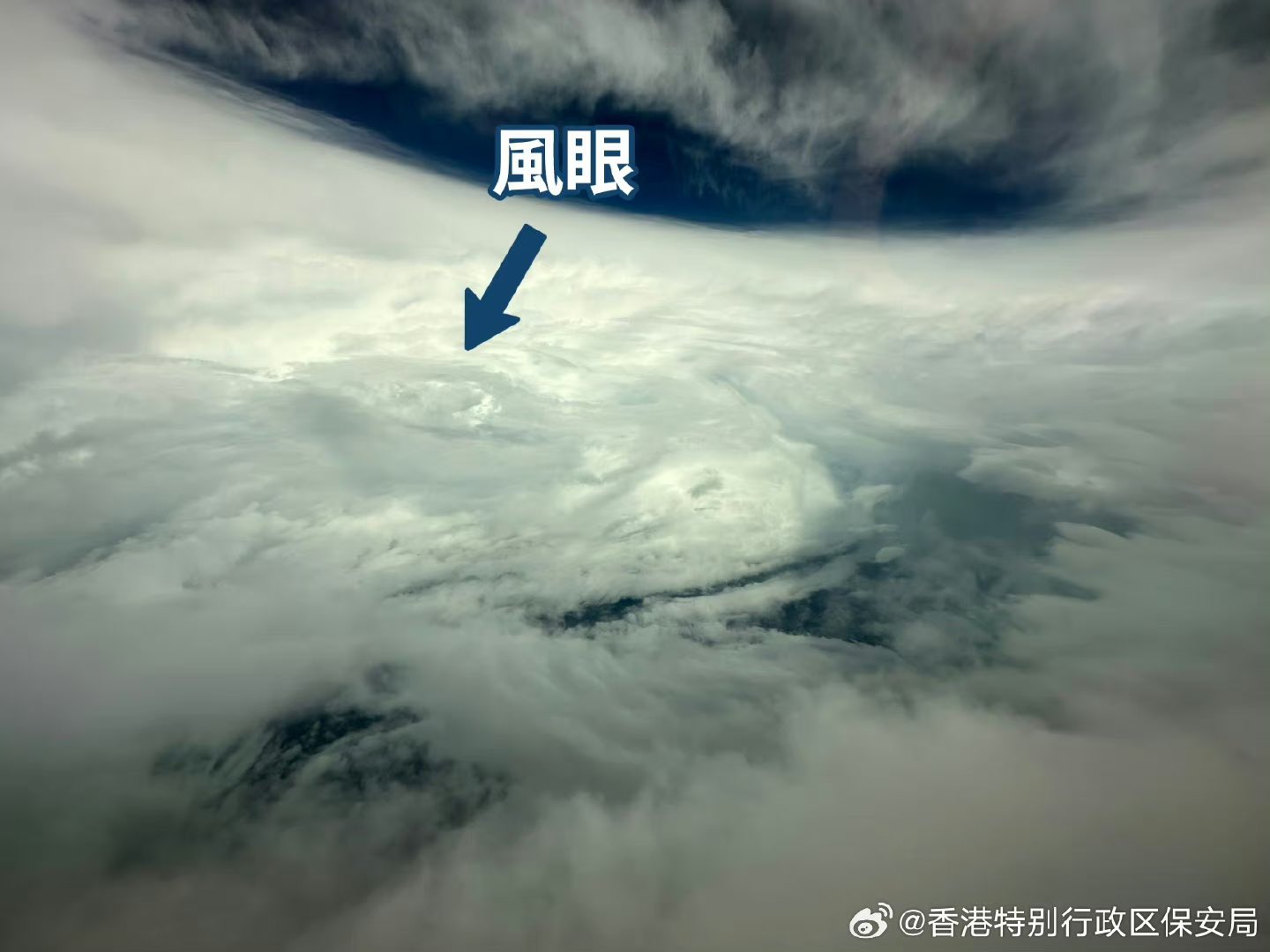
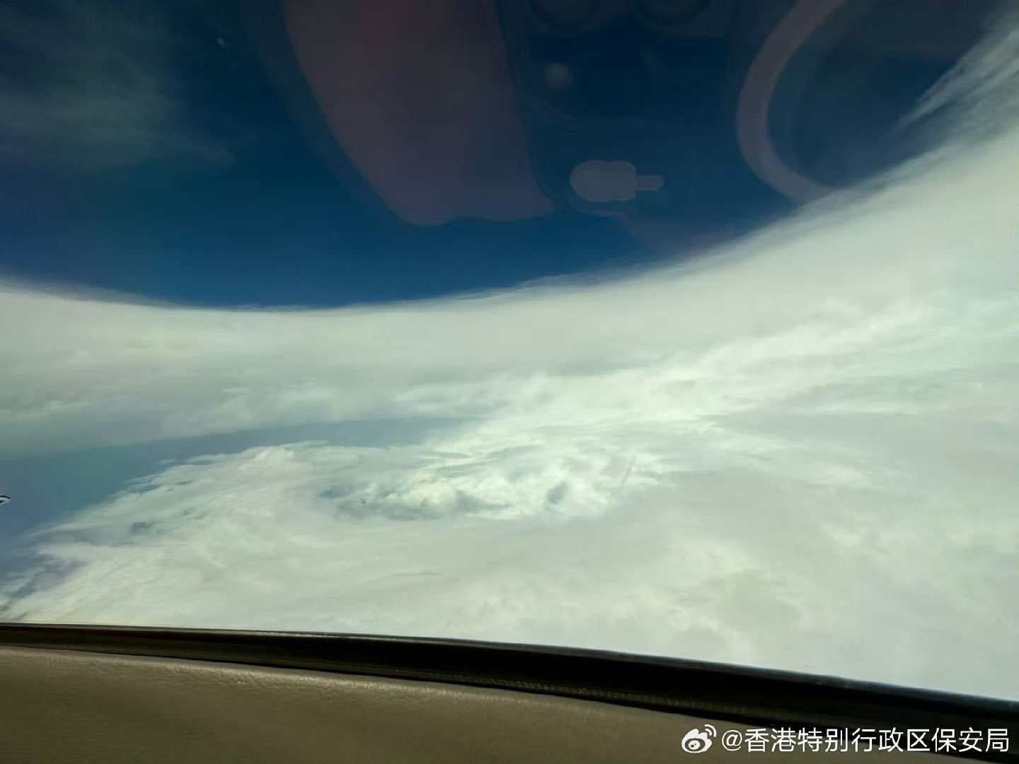
https://twitter.com/FansOfStorms/status/1697482227490140606
https://twitter.com/FansOfStorms/status/1697482227490140606
3 likes
Like my content? Consider giving a tip.
-
Kingarabian

- S2K Supporter

- Posts: 15451
- Joined: Sat Aug 08, 2009 3:06 am
- Location: Honolulu, Hawaii
Re: WPAC: SAOLA - Typhoon
StormTracker89 wrote:Kingarabian wrote:StormTracker89 wrote:JTWC too high on last two analyses based on coincident SAR passes from 2155z. RS2 showed 124kt while RCM3 showed 128kt. EWRC is ongoing and having an effect even if the Dvorak estimates have held steady. Interesting that agency fix Data-T numbers are all around T6.0 as well.
Well SAR isn't the most accurate estimate for TC intensity.
Are you saying that a subjective technique based on cloud temperatures and patterns is better than data collected by an active radar sensor? I fail to see how.
Lot's of cases where its estimates were not backed by recon and there are cases when it's estimates are above or below the more reliable Dvorak method.
0 likes
RIP Kobe Bryant
-
doomhaMwx
- Category 5
- Posts: 2398
- Age: 25
- Joined: Tue Apr 18, 2017 4:01 am
- Location: Baguio/Benguet, Philippines
- Contact:
Re: WPAC: SAOLA - Typhoon
FY-4B 1-minute interval rapid scan at sunset.

0 likes
Like my content? Consider giving a tip.
-
doomhaMwx
- Category 5
- Posts: 2398
- Age: 25
- Joined: Tue Apr 18, 2017 4:01 am
- Location: Baguio/Benguet, Philippines
- Contact:
-
doomhaMwx
- Category 5
- Posts: 2398
- Age: 25
- Joined: Tue Apr 18, 2017 4:01 am
- Location: Baguio/Benguet, Philippines
- Contact:
Re: WPAC: SAOLA - Typhoon
Several stations across Hong Kong are now registering gusts above 100kph tonight.

The eye will pass just south of Hong Kong Island within the next few hours.

Update: Waglan Island recorded 182kph (~98kts) gust at 8:30pm HKT.

The eye will pass just south of Hong Kong Island within the next few hours.
Update: Waglan Island recorded 182kph (~98kts) gust at 8:30pm HKT.
Last edited by doomhaMwx on Fri Sep 01, 2023 7:43 am, edited 2 times in total.
1 likes
Like my content? Consider giving a tip.
-
doomhaMwx
- Category 5
- Posts: 2398
- Age: 25
- Joined: Tue Apr 18, 2017 4:01 am
- Location: Baguio/Benguet, Philippines
- Contact:
Re: WPAC: SAOLA - Typhoon
Signal #10!
Bulletin issued at 20:20 HKT 01/Sep/2023
Tropical Cyclone Warning Bulletin
Here is the latest Tropical Cyclone Warning Bulletin issued by the Hong Kong Observatory.
The Hurricane Signal, No. 10, was issued at 8:15 p.m.
This means that winds with mean speeds of 118 kilometres per hour or more are expected.
At 8 p.m., Super Typhoon Saola was centred about 60 kilometres southeast of Hong Kong Observatory (near 22.0 degrees north 114.6 degrees east) and is forecast to move west or west-northwest at about 12 kilometres per hour across the vicinity of the Pearl River Estuary.
The eyewall of Super Typhoon Saola is now moving across Hong Kong, posing a high threat to Hong Kong. Hurricane force winds are affecting the eastern part of Hong Kong. According to the present forecast track, Saola will skirt around 40 kilometres to the south of the Hong Kong Observatory in the next few hours. The Hurricane Signal, No. 10 is expected to remain in force for some time. Northerly winds will change gradually to east to southeasterlies locally. Areas which were previously sheltered may become exposed. Members of the public should stay on high alert. You are advised to remain where you are if protected and be prepared for destructive winds.
Under the influence of storm surge, the water level in low-lying coastal areas will rise rapidly tonight. The water level in the eastern coastal waters of the territory will increase from around 9 p.m. tonight. Among which, the water level at Tolo Harbour will reach a high water level of around 6 metres above chart datum near midnight, which is about 4 metres higher than the normal tide level. The maximum water level may reach a historical record. The worst hit areas include Sha Tin, Tai Po, Sha Tau Kok, Sai Kung, etc. There will be serious flooding, the flood depth in some areas may be more than 1 metre.
The water levels over other coastal areas of Hong Kong will also start to rise significantly from around 6 a.m. tomorrow (2 September). The maximum water level at Victoria Harbour will be some 3 metres above chart datum. The water level in low-lying coastal areas such as Lei Yue Mun will be around 1.5 metres higher than the normal tide level. The water level at Tai O will reach around 3.5 metres above chart datum, which is nearly 2 metres above the normal tide level.
Seas will be phenomenal with swells. Members of the public are advised to stay away from the shoreline and not to engage in water sports.
In the past hour, the maximum sustained winds recorded at Waglan Island, Tate's Cairn and Cheung Chau were 117, 107 and 89 kilometres per hour with maximum gusts exceeding 144, 154 and 130 kilometres per hour respectively.
0 likes
Like my content? Consider giving a tip.
-
xtyphooncyclonex

- Category 5
- Posts: 3688
- Age: 22
- Joined: Sat Dec 08, 2012 9:07 am
- Location: Cebu City
- Contact:
Re: WPAC: SAOLA - Typhoon
The GFS has done a rather stellar job with Saola, especially compared to the ECMWF. They've been steadfast with the Batanes-Pearl River passage (or extreme south China) and held onto the storm keeping its intensity for days.
Side note, Saola has held >100kt major typhoon strength for nearly a week now (though nonconsecutive). Second such storm this season, the other being Mawar.
I'm wondering how the cities alongside the basin, being one of the most densely-populated areas on earth, are going to look like when they get up. It must be surreal seeing a major/intense one like Saola get this close go them. Hope they're faring well.
0 likes
REMINDER: My opinions that I, or any other NON Pro-Met in this forum, are unofficial. Please do not take my opinions as an official forecast and warning. I am NOT a meteorologist. Following my forecasts blindly may lead to false alarm, danger and risk if official forecasts from agencies are ignored.
-
doomhaMwx
- Category 5
- Posts: 2398
- Age: 25
- Joined: Tue Apr 18, 2017 4:01 am
- Location: Baguio/Benguet, Philippines
- Contact:
Re: WPAC: SAOLA - Typhoon
09W SAOLA 230901 1200 22.1N 114.4E WPAC 115 938

Looks like it weakened pretty quickly. It was probably a cat 4 at ~12Z, but definitely not one right now.
https://twitter.com/yangyubin1998/status/1697613733215060459
0 likes
Like my content? Consider giving a tip.
-
doomhaMwx
- Category 5
- Posts: 2398
- Age: 25
- Joined: Tue Apr 18, 2017 4:01 am
- Location: Baguio/Benguet, Philippines
- Contact:
Re: WPAC: SAOLA - Typhoon
Stations along the western coast of Macao are now reporting typhoon-force gusts as well. Saola is currently centered just to the southeast and moving WSW based on radar.


0 likes
Like my content? Consider giving a tip.
-
Sciencerocks
- Category 5
- Posts: 7287
- Age: 38
- Joined: Thu Jul 06, 2017 1:51 am

-
doomhaMwx
- Category 5
- Posts: 2398
- Age: 25
- Joined: Tue Apr 18, 2017 4:01 am
- Location: Baguio/Benguet, Philippines
- Contact:
Re: WPAC: SAOLA - Typhoon
Obs from Hong Kong during Saola:
Waglan Island (56m) recorded the highest sustained winds with 159kph. Highest gust was 189kph in Ngong Ping (593m), followed by 183kph in Waglan Island and Tate's Cairn (575m). Min SLP in Waglan was 979.1 mb at 8:51pm HKT.


Waglan Island (56m) recorded the highest sustained winds with 159kph. Highest gust was 189kph in Ngong Ping (593m), followed by 183kph in Waglan Island and Tate's Cairn (575m). Min SLP in Waglan was 979.1 mb at 8:51pm HKT.
0 likes
Like my content? Consider giving a tip.

Re: WPAC: SAOLA - Typhoon
[quote="doomhaMwx"]Obs from Hong Kong during Saola:
Waglan Island (56m) recorded the highest sustained winds with 159kph. Highest gust was 189kph in Ngong Ping (593m), followed by 183kph in Waglan Island and Tate's Cairn (575m). Min SLP in Waglan was 979.1 mb at 8:51pm HKT.
Thank you for posting such info on every storm, it really helps a lot and enhances the experience of being here!
1 likes
Personal Forecast Disclaimer:
The posts in this forum are NOT official forecast and should not be used as such. They are just the opinion of the poster and may or may not be backed by sound meteorological data. For official information, please refer to the NHC and NWS products.
The posts in this forum are NOT official forecast and should not be used as such. They are just the opinion of the poster and may or may not be backed by sound meteorological data. For official information, please refer to the NHC and NWS products.
-
Sciencerocks
- Category 5
- Posts: 7287
- Age: 38
- Joined: Thu Jul 06, 2017 1:51 am
Who is online
Users browsing this forum: No registered users and 23 guests