ATL: NANA - Models
Moderator: S2k Moderators
- cycloneye
- Admin

- Posts: 139328
- Age: 67
- Joined: Thu Oct 10, 2002 10:54 am
- Location: San Juan, Puerto Rico
ATL: NANA - Models
Only model runs here.
0 likes
Visit the Caribbean-Central America Weather Thread where you can find at first post web cams,radars
and observations from Caribbean basin members Click Here
and observations from Caribbean basin members Click Here
Re: ATL: INVEST 99L - Models
It will be interesting to see if the HWRF is being run this morning on 99L and what does it do with it. I am sure it would develop it into at least a TS with favorable conditions the global models show over the Caribbean through next week.
We shall know in a few minutes.
We shall know in a few minutes.
0 likes
Re: ATL: INVEST 99L - Models
The irony is that during 2013 models would absolutely blow this up into a cane, only for it to likely not verify. This season has been the opposite
3 likes
- Rgv20
- S2K Supporter

- Posts: 2456
- Age: 37
- Joined: Wed Jan 05, 2011 5:42 pm
- Location: Edinburg/McAllen Tx
Re: ATL: INVEST 99L - Models
0 likes
The following post is NOT an official forecast and should not be used as such. It is just the opinion of the poster and may or may not be backed by sound meteorological data. It is NOT endorsed by any professional institution including storm2k.org For Official Information please refer to the NHC and NWS products.
-
shiny-pebble
- Category 1

- Posts: 299
- Joined: Thu Jul 05, 2018 1:38 pm
Re: ATL: INVEST 99L - Models
HMON has a TS in 6 hours

But weakens after


But weakens after

0 likes
Not an meteorologist! Just someone who is interested in weather. Please refer to the NHC and local weather officials to make decisions.
-Jack
-Jack
Re: ATL: INVEST 99L - Models
0z Canadian wanted to take this over Central America and reformed it in the east pacific. 12z is pretty much the same.
Last edited by BobHarlem on Sun Aug 30, 2020 12:01 pm, edited 1 time in total.
1 likes
- gatorcane
- S2K Supporter

- Posts: 23499
- Age: 46
- Joined: Sun Mar 13, 2005 3:54 pm
- Location: Boca Raton, FL
Re: ATL: INVEST 99L - Models
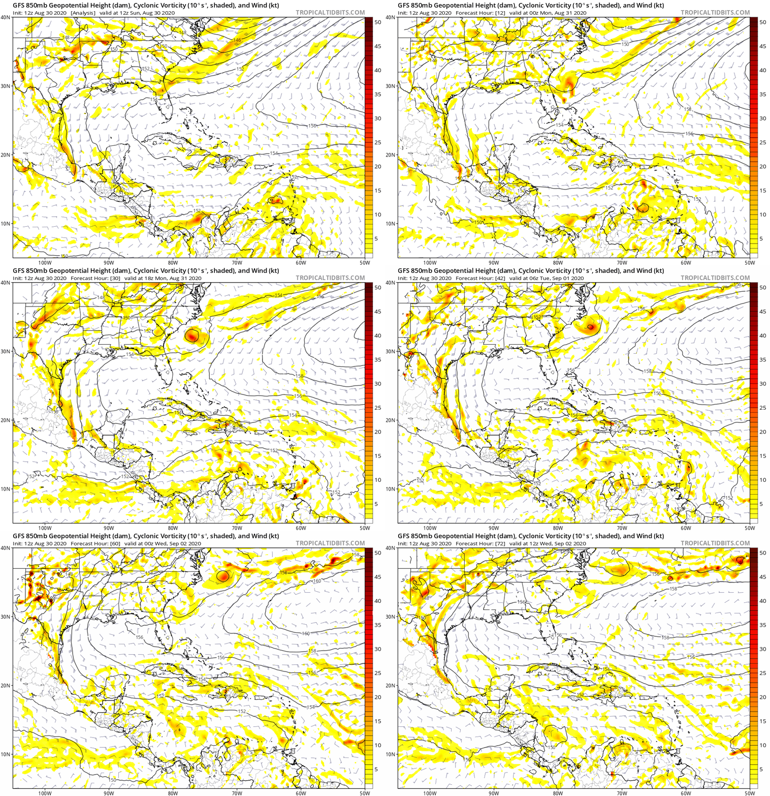
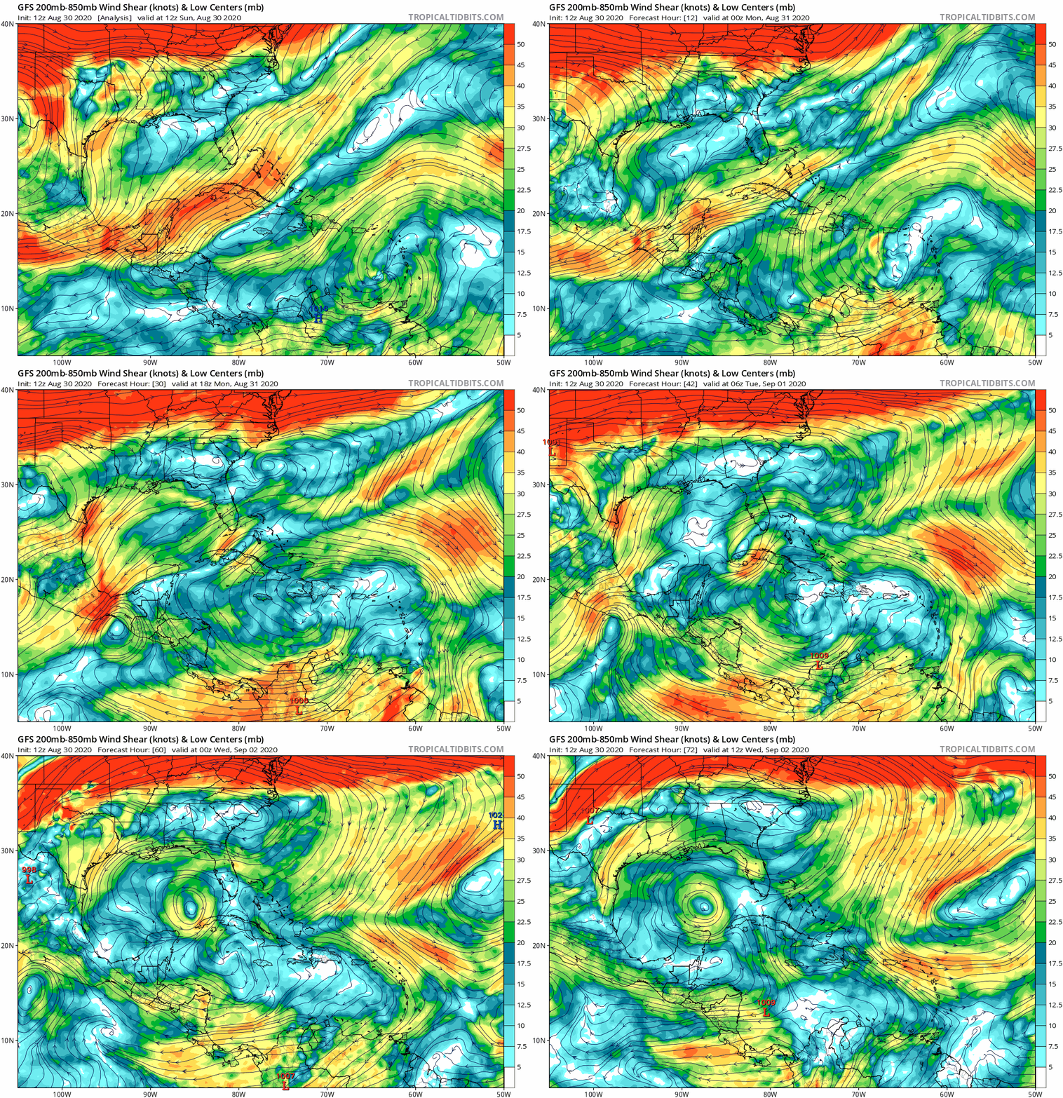
The GFS doesn’t appear to develop because it looks like the upper-anticyclone is just a bit too far north while moving in tandem with 99l. See animations below:


0 likes
Re: ATL: INVEST 99L - Models
gatorcane wrote:The GFS doesn’t appear to develop because it looks like the upper-anticyclone is just a bit too far north while moving in tandem with 99l. See animations below:
https://i.postimg.cc/HnfYSQTX/gfs-z850-vort-watl-fh0-72.gif
https://i.postimg.cc/yYy6h3wg/gfs-shear-watl-fh0-72.gif
Thanks for directing me from the discussion thread, to your models post....does this show the shear forecasts?....I'm not very good at models, so I appreciate your input as always...also...can you offer your thoughts on a likely track?
0 likes
-
Aric Dunn
- Category 5

- Posts: 21228
- Age: 41
- Joined: Sun Sep 19, 2004 9:58 pm
- Location: Ready for the Chase.
- Contact:
Re: ATL: INVEST 99L - Models
HMON. hurricane heading for Belize. besides a brief weakening in 24 hurs the HMON has a moderate TS trough the carrib then becomes a hurricane.


0 likes
Note: If I make a post that is brief. Please refer back to previous posts for the analysis or reasoning. I do not re-write/qoute what my initial post said each time.
If there is nothing before... then just ask
Space & Atmospheric Physicist, Embry-Riddle Aeronautical University,
I believe the sky is falling...
If there is nothing before... then just ask
Space & Atmospheric Physicist, Embry-Riddle Aeronautical University,
I believe the sky is falling...
- Hypercane_Kyle
- Category 5

- Posts: 2900
- Joined: Sat Mar 07, 2015 7:58 pm
- Location: Cape Canaveral, FL
Re: ATL: INVEST 99L - Models
12z HWRF looking similar to the 12z HMON.
Another big global model fail coming up? We'll see.
Another big global model fail coming up? We'll see.
4 likes
My posts are my own personal opinion, defer to the National Hurricane Center (NHC) and other NOAA products for decision making during hurricane season.
Re: ATL: INVEST 99L - Models
Aric Dunn wrote:HMON. hurricane heading for Belize. besides a brief weakening in 24 hurs the HMON has a moderate TS trough the carrib then becomes a hurricane.
https://www.tropicaltidbits.com/analysis/models/hmon/2020083012/hmon_mslp_wind_99L_29.png
Hey Aric...what exactly is the HMON...and how reliable is it in your view?...I feel that 99L is gonna be a system that intensifies at a bit faster pace than other disturbances...based on the way it looks on satellite images...to me, it sometimes seems obvious by just looking at it on satellite....
1 likes
Re: ATL: INVEST 99L - Models
The HMON and HWRF both track 99L a little north so that it misses Nicaragua/Honduras and spends more time over water, before making landfall in Belize as a strong TS/weak hurricane in 90-96 hours.
0 likes
Irene '11 Sandy '12 Hermine '16 5/15/2018 Derecho Fay '20 Isaias '20 Elsa '21 Henri '21 Ida '21
I am only a meteorology enthusiast who knows a decent amount about tropical cyclones. Look to the professional mets, the NHC, or your local weather office for the best information.
I am only a meteorology enthusiast who knows a decent amount about tropical cyclones. Look to the professional mets, the NHC, or your local weather office for the best information.
Re: ATL: INVEST 99L - Models
underthwx wrote:Aric Dunn wrote:HMON. hurricane heading for Belize. besides a brief weakening in 24 hurs the HMON has a moderate TS trough the carrib then becomes a hurricane.
https://www.tropicaltidbits.com/analysis/models/hmon/2020083012/hmon_mslp_wind_99L_29.png
Hey Aric...what exactly is the HMON...and how reliable is it in your view?...I feel that 99L is gonna be a system that intensifies at a bit faster pace than other disturbances...based on the way it looks on satellite images...to me, it sometimes seems obvious by just looking at it on satellite....
It's the newest dynamical hurricane model from ncep.
Last year it was as good as any model for short term intensity. It fell off for longer term forecasts.
1 likes
- cheezyWXguy
- Category 5

- Posts: 5556
- Joined: Mon Feb 13, 2006 12:29 am
- Location: Dallas, TX
Re: ATL: INVEST 99L - Models
RL3AO wrote:underthwx wrote:Aric Dunn wrote:HMON. hurricane heading for Belize. besides a brief weakening in 24 hurs the HMON has a moderate TS trough the carrib then becomes a hurricane.
https://www.tropicaltidbits.com/analysis/models/hmon/2020083012/hmon_mslp_wind_99L_29.png
Hey Aric...what exactly is the HMON...and how reliable is it in your view?...I feel that 99L is gonna be a system that intensifies at a bit faster pace than other disturbances...based on the way it looks on satellite images...to me, it sometimes seems obvious by just looking at it on satellite....
It's the newest dynamical hurricane model from ncep.
Last year it was as good as any model for short term intensity. It fell off for longer term forecasts.
Didn’t it replace the old GFDL?
0 likes
- MississippiWx
- S2K Supporter

- Posts: 1535
- Joined: Sat Aug 14, 2010 1:44 pm
- Location: Hattiesburg, Mississippi
Re: ATL: INVEST 99L - Models
The global models have been solid on track once a TC forms, but sheesh. I can’t understand the lack of skill in genesis this season. The hurricane models have my attention.
2 likes
This post is not an official forecast and should not be used as such. It is just the opinion of MississippiWx and may or may not be backed by sound meteorological data. It is not endorsed by any professional institution including storm2k.org. For Official Information please refer to the NHC and NWS products.
Re: ATL: INVEST 99L - Models
It's plotting the no land version of SHIPS. The land version has it weakening after landfall
0 likes
Re: ATL: INVEST 99L - Models
SHIP
* GFS version *
* ATLANTIC 2020 SHIPS INTENSITY FORECAST *
* IR SAT DATA AVAILABLE, OHC AVAILABLE *
* INVEST AL992020 08/30/20 18 UTC *
TIME (HR) 0 6 12 18 24 36 48 60 72 84 96 108 120 132 144 156 168
V (KT) NO LAND 25 26 27 29 32 38 44 52 59 64 69 74 79 85 87 92 94
V (KT) LAND 25 26 27 29 32 38 44 52 59 64 69 74 52 35 29 28 27
V (KT) LGEM 25 25 26 27 28 30 34 39 46 53 62 72 54 35 29 N/A N/A
Storm Type TROP TROP TROP TROP TROP TROP TROP TROP TROP TROP TROP TROP TROP TROP TROP N/A N/A
SHEAR (KT) 12 15 15 16 17 13 17 7 13 8 6 9 11 5 12 N/A N/A
SHEAR ADJ (KT) 4 5 1 0 2 0 0 0 0 -2 -3 0 3 4 4 N/A N/A
SHEAR DIR 70 79 81 64 54 61 27 342 358 6 59 310 22 7 27 N/A N/A
SST (C) 29.0 29.0 28.9 28.8 28.8 28.6 28.8 28.9 28.6 28.8 29.3 30.3 31.0 29.7 29.2 N/A N/A
POT. INT. (KT) 153 153 151 150 149 146 149 151 147 150 158 172 172 163 154 N/A N/A
ADJ. POT. INT. 153 153 151 150 149 144 146 148 143 147 156 172 172 155 144 N/A N/A
200 MB T (C) -52.7 -52.8 -53.3 -53.7 -53.3 -53.3 -53.2 -53.0 -53.1 -52.9 -53.0 -52.9 -53.1 -53.1 -53.2 N/A N/A
200 MB VXT (C) 0.0 0.1 0.2 0.2 0.1 0.1 0.0 0.0 0.0 0.0 0.0 0.0 0.0 0.0 0.0 N/A N/A
TH_E DEV (C) 10 9 8 8 10 9 11 11 10 9 10 9 9 7 8 N/A N/A
700-500 MB RH 64 66 64 63 64 67 66 69 66 70 69 72 71 77 76 N/A N/A
MODEL VTX (KT) 10 9 8 7 7 6 LOST LOST LOST LOST LOST LOST LOST LOST LOST LOST LOST
850 MB ENV VOR 94 80 60 65 74 80 82 77 58 62 64 77 72 73 45 N/A N/A
200 MB DIV 46 70 68 73 49 46 37 38 42 39 16 51 55 66 35 N/A N/A
700-850 TADV 4 4 4 3 7 6 7 7 -3 2 5 1 3 6 5 N/A N/A
LAND (KM) 211 270 293 255 233 268 267 167 177 255 96 84 -108 -211 -119 N/A N/A
LAT (DEG N) 12.6 xx.x xx.x xx.x xx.x xx.x xx.x xx.x xx.x xx.x xx.x xx.x xx.x xx.x xx.x xx.x xx.x
LONG(DEG W) 64.0 xxx.x xxx.x xxx.x xxx.x xxx.x xxx.x xxx.x xxx.x xxx.x xxx.x xxx.x xxx.x xxx.x xxx.x xxx.x xxx.x
STM SPEED (KT) 14 13 13 13 12 12 12 13 13 13 13 12 11 8 7 N/A N/A
HEAT CONTENT 46 42 43 45 46 58 55 114 74 58 59 67 43 8 13 N/A N/A
FORECAST TRACK FROM OFPI INITIAL HEADING/SPEED (DEG/KT):280/ 15 CX,CY: -14/ 3
T-12 MAX WIND: 25 PRESSURE OF STEERING LEVEL (MB): 522 (MEAN=620)
GOES IR BRIGHTNESS TEMP. STD DEV. 50-200 KM RAD: 12.5 (MEAN=14.5)
% GOES IR PIXELS WITH T < -20 C 50-200 KM RAD: 84.0 (MEAN=65.0)
PRELIM RI PROB (DV .GE. 35 KT IN 36 HR): 6.7
INDIVIDUAL CONTRIBUTIONS TO INTENSITY CHANGE
6 12 18 24 36 48 60 72 84 96 108 120 132 144 156 168
------------------------------------------------------------------------------
SAMPLE MEAN CHANGE 1. 2. 3. 4. 6. 8. 9. 10. 11. 12. 12. 13. 14. 14. 15. 16.
SST POTENTIAL -0. -1. -1. -1. 2. 8. 16. 21. 26. 29. 33. 37. 41. 43. 45. 44.
VERTICAL SHEAR MAG 1. 2. 3. 3. 4. 4. 4. 3. 3. 3. 4. 3. 4. 4. 4. 5.
VERTICAL SHEAR ADJ -0. -0. -0. -1. -1. -1. -0. 0. 1. 1. 1. 1. 0. 0. 0. 0.
VERTICAL SHEAR DIR 0. 1. 1. 2. 4. 6. 7. 8. 9. 9. 9. 10. 11. 11. 11. 11.
PERSISTENCE -0. -1. -1. -1. -0. -0. -0. -0. -0. 0. 0. 0. -0. -0. -1. -0.
200/250 MB TEMP. -0. -1. -1. -1. -1. -1. -1. -1. -1. -1. -1. -1. -1. 0. 1. 2.
THETA_E EXCESS 0. 0. 0. 0. 0. 0. 1. 0. 0. 0. 0. 0. 0. 0. 0. -0.
700-500 MB RH -0. -0. -0. -1. -1. -2. -3. -4. -4. -5. -5. -5. -5. -6. -6. -5.
MODEL VTX TENDENCY -0. -1. -2. -3. -4. -7. -8. -10. -11. -12. -13. -13. -13. -13. -13. -13.
850 MB ENV VORTICITY 0. 0. 1. 1. 1. 2. 2. 2. 2. 3. 3. 3. 3. 3. 4. 4.
200 MB DIVERGENCE 0. 0. 1. 1. 1. 1. 1. 1. 1. 0. -0. -0. -1. -1. -1. -1.
850-700 T ADVEC -0. 0. 0. 0. 0. 0. 0. 0. 0. 0. 0. 0. 0. 0. 0. 0.
ZONAL STORM MOTION -0. -0. 0. 0. 1. 1. 1. 1. 2. 3. 3. 3. 3. 3. 3. 4.
STEERING LEVEL PRES 0. 0. 0. 0. 1. 1. 0. 1. 1. 1. 2. 2. 1. 1. 1. 1.
DAYS FROM CLIM. PEAK 0. -0. -0. -0. -0. 0. 0. -0. -0. -0. -0. -0. -0. -1. -1. -1.
GOES PREDICTORS 1. 1. 1. 1. 1. 1. 0. -0. -1. -1. -1. -0. 1. 1. 2. 1.
OCEAN HEAT CONTENT 0. 0. 0. 0. 0. 0. -0. 0. 0. 0. 0. 0. -0. -0. -0. -0.
RI POTENTIAL -0. -0. -0. -1. -1. -1. -1. -1. -0. 0. 1. 1. 1. 2. 2. 2.
------------------------------------------------------------------------------
TOTAL CHANGE 1. 2. 4. 7. 13. 19. 27. 34. 39. 44. 49. 54. 60. 62. 67. 69.
CURRENT MAX WIND (KT): 25. LAT, LON: 12.6 64.0
** 2020 ATLANTIC RI INDEX AL992020 INVEST 08/30/20 18 UTC **
(SHIPS-RII PREDICTOR TABLE for 30 KT OR MOREMAXIMUM WIND INCREASE IN NEXT 24-h)
Predictor Value RI Predictor Range Scaled Value(0-1) % Contribution
12 HR PERSISTENCE (KT) : 0.0 -49.5 to 33.0 0.60 4.7
850-200 MB SHEAR (KT) : 14.9 30.1 to 2.3 0.55 1.7
HEAT CONTENT (KJ/CM2) : 44.4 0.0 to 151.8 0.29 0.8
STD DEV OF IR BR TEMP : 12.5 36.6 to 2.8 0.71 2.3
MAXIMUM WIND (KT) : 25.0 22.5 to 137.5 0.07 0.1
2nd PC OF IR BR TEMP : 0.5 2.9 to -2.9 0.41 0.9
BL DRY-AIR FLUX (W/M2) : 108.2 895.4 to -55.0 0.83 1.7
POT = MPI-VMAX (KT) : 126.2 27.5 to 139.6 0.88 0.7
D200 (10**7s-1) : 61.2 -29.7 to 185.9 0.42 0.2
%area of TPW <45 mm upshear : 0.0 100.0 to 0.0 1.00 0.2
SHIPS Prob RI for 20kt/ 12hr RI threshold= 6% is 1.2 times climatological mean ( 5.0%)
SHIPS Prob RI for 25kt/ 24hr RI threshold= 19% is 1.7 times climatological mean (10.9%)
SHIPS Prob RI for 30kt/ 24hr RI threshold= 13% is 1.9 times climatological mean ( 6.9%)
SHIPS Prob RI for 35kt/ 24hr RI threshold= 10% is 2.5 times climatological mean ( 3.9%)
SHIPS Prob RI for 40kt/ 24hr RI threshold= 0% is 0.0 times climatological mean ( 2.5%)
SHIPS Prob RI for 45kt/ 36hr RI threshold= 0% is 0.0 times climatological mean ( 4.6%)
SHIPS Prob RI for 55kt/ 48hr RI threshold= 11% is 2.4 times climatological mean ( 4.6%)
SHIPS Prob RI for 65kt/ 72hr RI threshold= 0% is 0.0 times climatological mean ( 5.2%)
Matrix of RI probabilities
------------------------------------------------------------------------------
RI (kt / h) | 20/12 | 25/24 | 30/24 | 35/24 | 40/24 | 45/36 | 55/48 |65/72
------------------------------------------------------------------------------
SHIPS-RII: 5.9% 19.0% 13.3% 9.7% 0.0% 0.0% 11.1% 0.0%
Logistic: 4.1% 20.5% 9.1% 6.2% 6.5% 14.8% 18.8% 54.4%
Bayesian: 0.4% 23.9% 2.8% 0.3% 0.1% 0.7% 1.4% 22.1%
Consensus: 3.5% 21.1% 8.4% 5.4% 2.2% 5.2% 10.4% 25.5%
DTOPS: 0.0% 0.0% 0.0% 0.0% 0.0% 0.0% 0.0% 0.0%
## ANNULAR HURRICANE INDEX (AHI) AL992020 INVEST 08/30/20 18 UTC ##
## STORM NOT ANNULAR, SCREENING STEP FAILED, NPASS=4 NFAIL=3 ##
## AHI= 0 (AHI OF 100 IS BEST FIT TO ANN. STRUC., 1 IS MARGINAL, 0 IS NOT ANNULAR) ##
** PROBLTY OF AT LEAST 1 SCNDRY EYEWL FORMTN EVENT AL992020 INVEST 08/30/2020 18 UTC **
TIME(HR) 0-12 12-24(0-24) 24-36(0-36) 36-48(0-48)
CLIMO(%) 0 0( 0) 0( 0) 0( 0) <-- PROB BASED ON INTENSITY ONLY
PROB(%) 0 0( 0) 0( 0) 0( 0) <-- FULL MODEL PROB (RAN NORMALLY)
** DSHIPS INTENSITY FORECAST ADJUSTED RELATIVE TO ONSET OF ERC WEAKENING PHASE **
TIME (HR) 0 6 12 18 24 36 48 60 72 84 96 108 120 132 144 156 168
>24HR AGO (DSHIPS) 25 26 27 29 32 38 44 52 59 64 69 74 52 35 29 28 27
18HR AGO 25 24 25 27 30 36 42 50 57 62 67 72 50 33 27 26 25
12HR AGO 25 22 21 23 26 32 38 46 53 58 63 68 46 29 23 22 21
6HR AGO 25 19 16 15 18 24 30 38 45 50 55 60 38 21 15 DIS DIS
NOW CURRENT INTENSITY < 83 KT
IN 6HR INTENSITY IN 6HR < 83 KT
IN 12HR INTENSITY IN 12HR < 83 KT
0 likes
Re: ATL: INVEST 99L - Models
RL3AO wrote:It's plotting the no land version of SHIPS. The land version has it weakening after landfall
Yeah, that is why changed it to the full output, still has a 74 kt timepoint
0 likes
Who is online
Users browsing this forum: No registered users and 21 guests


