
ATL: ARTHUR - Post-Tropical
Moderator: S2k Moderators
-
cycloneye

- Admin

- Posts: 139346
- Age: 67
- Joined: Thu Oct 10, 2002 10:54 am
- Location: San Juan, Puerto Rico
ATL: ARTHUR - Post-Tropical
Thread for Invest 90L is opened as recon has been tasked for Friday so post away.
1 likes
Visit the Caribbean-Central America Weather Thread where you can find at first post web cams,radars
and observations from Caribbean basin members Click Here
and observations from Caribbean basin members Click Here
-
Aric Dunn
- Category 5

- Posts: 21228
- Age: 41
- Joined: Sun Sep 19, 2004 9:58 pm
- Location: Ready for the Chase.
- Contact:
Re: ATL: INVEST 90L - Discussion
Speak of the devil.. lol
1 likes
Note: If I make a post that is brief. Please refer back to previous posts for the analysis or reasoning. I do not re-write/qoute what my initial post said each time.
If there is nothing before... then just ask
Space & Atmospheric Physicist, Embry-Riddle Aeronautical University,
I believe the sky is falling...
If there is nothing before... then just ask
Space & Atmospheric Physicist, Embry-Riddle Aeronautical University,
I believe the sky is falling...
-
Aric Dunn
- Category 5
- Posts: 21228
- Age: 41
- Joined: Sun Sep 19, 2004 9:58 pm
- Location: Ready for the Chase.
- Contact:
Re: ATL: INVEST 90L - Discussion
I love when development happens in radar range.
8 likes
Note: If I make a post that is brief. Please refer back to previous posts for the analysis or reasoning. I do not re-write/qoute what my initial post said each time.
If there is nothing before... then just ask
Space & Atmospheric Physicist, Embry-Riddle Aeronautical University,
I believe the sky is falling...
If there is nothing before... then just ask
Space & Atmospheric Physicist, Embry-Riddle Aeronautical University,
I believe the sky is falling...


Re: ATL: INVEST 90L - Discussion
Man I hope we at least get some good rainfall here in South Florida, my lawn really needs it.
5 likes
FSU '24 student pursuing a degree in meteorology. Consult NHC for official information.
-
Aric Dunn
- Category 5
- Posts: 21228
- Age: 41
- Joined: Sun Sep 19, 2004 9:58 pm
- Location: Ready for the Chase.
- Contact:
Re: ATL: INVEST 90L - Discussion
Looks like the circulation that is becoming more pronounced on radar rather quickly. is at about 4500 feet.
if convection sustains itself the way it is. it wont take long for the pressure to fall at the surface.
if convection sustains itself the way it is. it wont take long for the pressure to fall at the surface.
1 likes
Note: If I make a post that is brief. Please refer back to previous posts for the analysis or reasoning. I do not re-write/qoute what my initial post said each time.
If there is nothing before... then just ask
Space & Atmospheric Physicist, Embry-Riddle Aeronautical University,
I believe the sky is falling...
If there is nothing before... then just ask
Space & Atmospheric Physicist, Embry-Riddle Aeronautical University,
I believe the sky is falling...
-
SFLcane

- S2K Supporter

- Posts: 9617
- Age: 46
- Joined: Sat Jun 05, 2010 1:44 pm
- Location: Lake Worth Florida
Re: ATL: INVEST 90L - Discussion
Aric Dunn wrote:Looks like the circulation that is becoming more pronounced on radar rather quickly. is at about 4500 feet.
if convection sustains itself the way it is. it wont take long for the pressure to fall at the surface.
Aric, can you point out we’re you think the low is developing? Thanks
0 likes
-
Aric Dunn
- Category 5
- Posts: 21228
- Age: 41
- Joined: Sun Sep 19, 2004 9:58 pm
- Location: Ready for the Chase.
- Contact:
Re: ATL: INVEST 90L - Discussion
SFLcane wrote:Aric Dunn wrote:Looks like the circulation that is becoming more pronounced on radar rather quickly. is at about 4500 feet.
if convection sustains itself the way it is. it wont take long for the pressure to fall at the surface.
Aric, can you point out we’re you think the low is developing? Thanks
I think it is pretty straight forward.. also there is still shear so anything that forms at surface will likely get spit out a couple times.
but impressive nonetheless for this little guy.


1 likes
Note: If I make a post that is brief. Please refer back to previous posts for the analysis or reasoning. I do not re-write/qoute what my initial post said each time.
If there is nothing before... then just ask
Space & Atmospheric Physicist, Embry-Riddle Aeronautical University,
I believe the sky is falling...
If there is nothing before... then just ask
Space & Atmospheric Physicist, Embry-Riddle Aeronautical University,
I believe the sky is falling...
-
gatorcane

- S2K Supporter
- Posts: 23499
- Age: 46
- Joined: Sun Mar 13, 2005 3:54 pm
- Location: Boca Raton, FL
Re: ATL: INVEST 90L - Discussion
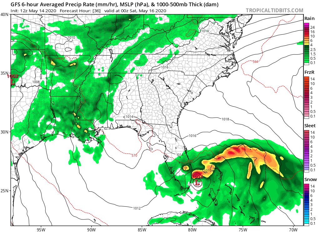
The GFS has shifted a bit more west as it passes South Florida
1 likes
-
Evil Jeremy

- S2K Supporter
- Posts: 5459
- Age: 31
- Joined: Mon Apr 10, 2006 2:10 pm
- Location: Los Angeles, CA
Re: ATL: INVEST 90L - Discussion
It's that time of year again. Certainly, the weather yesterday and this morning has been indicative of nearby tropical activity. The constant cool breeze, clouds look like they're in a rush to get somewhere. It's entirely overcast today, and hopefully tomorrow/Saturday we get the drenching we anticipated last weekend.
2 likes
Frances 04 / Jeanne 04 / Katrina 05 / Wilma 05 / Fay 08 / Debby 12 / Andrea 13 / Colin 16 / Hermine 16 / Matthew 16 / Irma 17

Re: ATL: INVEST 90L - Discussion
We need 90L to move due north not NE for South Florida to get good rains otherwise it might clip us but mostly east of us.
0 likes
Re: ATL: INVEST 90L - Discussion
Aric Dunn wrote:Looks like the circulation that is becoming more pronounced on radar rather quickly. is at about 4500 feet.
if convection sustains itself the way it is. it wont take long for the pressure to fall at the surface.
Do you think today is possible? Radar looks amazing but the models want another 48 hours.
0 likes
Eyes: Emily '86, Dean '89, Felix '95, Gert '99, Fabian '03, Humberto '19, Paulette '20

Re: ATL: INVEST 90L - Discussion
High helicity tower fired off with lightning.
Looking better and better.
Looking better and better.
0 likes
-
Aric Dunn
- Category 5
- Posts: 21228
- Age: 41
- Joined: Sun Sep 19, 2004 9:58 pm
- Location: Ready for the Chase.
- Contact:
Re: ATL: INVEST 90L - Discussion
plasticup wrote:Aric Dunn wrote:Looks like the circulation that is becoming more pronounced on radar rather quickly. is at about 4500 feet.
if convection sustains itself the way it is. it wont take long for the pressure to fall at the surface.
Do you think today is possible? Radar looks amazing but the models want another 48 hours.
for an upgrade? probably not. NHC will wait for recon or the circ to pass close enough to surface obs.
tomorrow most likely given the current rate of things. luckily it is in radar range.
0 likes
Note: If I make a post that is brief. Please refer back to previous posts for the analysis or reasoning. I do not re-write/qoute what my initial post said each time.
If there is nothing before... then just ask
Space & Atmospheric Physicist, Embry-Riddle Aeronautical University,
I believe the sky is falling...
If there is nothing before... then just ask
Space & Atmospheric Physicist, Embry-Riddle Aeronautical University,
I believe the sky is falling...
Re: ATL: INVEST 90L - Discussion
plasticup wrote:Aric Dunn wrote:Looks like the circulation that is becoming more pronounced on radar rather quickly. is at about 4500 feet.
if convection sustains itself the way it is. it wont take long for the pressure to fall at the surface.
Do you think today is possible? Radar looks amazing but the models want another 48 hours.
I wouldn't call it "amazing" but certainly better than I thought it would at this point
0 likes
FSU '24 student pursuing a degree in meteorology. Consult NHC for official information.
Re: ATL: INVEST 90L - Discussion
Looks really good on lower-level water vapor satellite.
Firing off a very distinct dry-line like something you would see in west Texas.
Firing off a very distinct dry-line like something you would see in west Texas.
0 likes
Re: ATL: INVEST 90L - Discussion
Looks like enough CAPE and clear skies to fire off popup thunderstorms over west Cuba this afternoon.
Same old routine.
Convective debris will this evening entrain into the LL vort and moisten the mid-levels up.
Very likely early Friday morning around DMAX will see the best chance for heavy convection and a spin up later in the day.
Same old routine.
Convective debris will this evening entrain into the LL vort and moisten the mid-levels up.
Very likely early Friday morning around DMAX will see the best chance for heavy convection and a spin up later in the day.
1 likes
-
jlauderdal
- S2K Supporter
- Posts: 6776
- Joined: Wed May 19, 2004 5:46 am
- Location: NE Fort Lauderdale
- Contact:
Re: ATL: INVEST 90L - Discussion
its been very difficult to make rain the last 60 days....there is a chance this one doesn't do much better as it slides to the eastIan2401 wrote:Man I hope we at least get some good rainfall here in South Florida, my lawn really needs it.
0 likes
-
Aric Dunn
- Category 5
- Posts: 21228
- Age: 41
- Joined: Sun Sep 19, 2004 9:58 pm
- Location: Ready for the Chase.
- Contact:
Re: ATL: INVEST 90L - Discussion
GCANE wrote:Looks like enough CAPE and clear skies to fire off popup thunderstorms over west Cuba this afternoon.
Same old routine.
Convective debris will this evening entrain into the LL vort and moisten the mid-levels up.
Very likely early Friday morning around DMAX will see the best chance for heavy convection and a spin up later in the day.
yeah, however the pops over cuba are already being pulled ene at the 850 mb level into that convective complex. outflowvboundaries from the land convection will also push northward likely helping to close this off overnight.
0 likes
Note: If I make a post that is brief. Please refer back to previous posts for the analysis or reasoning. I do not re-write/qoute what my initial post said each time.
If there is nothing before... then just ask
Space & Atmospheric Physicist, Embry-Riddle Aeronautical University,
I believe the sky is falling...
If there is nothing before... then just ask
Space & Atmospheric Physicist, Embry-Riddle Aeronautical University,
I believe the sky is falling...
-
Aric Dunn
- Category 5
- Posts: 21228
- Age: 41
- Joined: Sun Sep 19, 2004 9:58 pm
- Location: Ready for the Chase.
- Contact:
Re: ATL: INVEST 90L - Discussion
GCANE wrote:The LL vort hasn't moved at all since dawn.
you see the doppler velocities the couplet continues to grow? .. mescoscale features slowly dropping the pressure field.
0 likes
Note: If I make a post that is brief. Please refer back to previous posts for the analysis or reasoning. I do not re-write/qoute what my initial post said each time.
If there is nothing before... then just ask
Space & Atmospheric Physicist, Embry-Riddle Aeronautical University,
I believe the sky is falling...
If there is nothing before... then just ask
Space & Atmospheric Physicist, Embry-Riddle Aeronautical University,
I believe the sky is falling...
Who is online
Users browsing this forum: No registered users and 8 guests