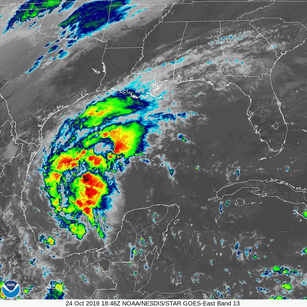
ATL: OLGA - Post-Tropical - Discussion

Moderator: S2k Moderators

Message
Author
User avatar
chaser1
S2K Supporter
S2K Supporter
Posts: 4720
Age: 63
Joined: Sat Oct 15, 2005 5:59 pm
Location: Longwood, Fl

Re: ATL: INVEST 97L - Discussion

#21 Postby chaser1 » Thu Oct 24, 2019 11:46 am

panamatropicwatch wrote:This is from one of our local meteorologist here in Panama City. I hope he is right but I don't know if I would make such a definitive statement at this stage of the game.
http://tropicwatch.info/definitive102420191537z.jpg


For the most part I think he's spot on. I think this is more an interest from a meteorological geek perspective (which naturally does include a good number of us posters here :lol: ). I highly doubt this will present any real risk to Gulf coastal area. Furthermore, after the most recent tropical abortion I doubt that NHC is in any hurry to be trigger happy with this next one (even if it does ultimately become more worthy of T.D. designation tonight or tomorrow).
0 likes   
Personal Forecast Disclaimer:
The posts in this forum are NOT official forecast and should not be used as such. They are just the opinion of the poster and may or may not be backed by sound meteorological data. They are NOT endorsed by any professional institution or storm2k.org. For official information, please refer to the NHC and NWS products.


User avatar
northjaxpro
S2K Supporter
S2K Supporter
Posts: 8900
Joined: Mon Sep 27, 2010 11:21 am
Location: Jacksonville, FL

Re: ATL: INVEST 97L - Discussion

#22 Postby northjaxpro » Thu Oct 24, 2019 11:46 am

The window for this to develop into its own entity is so small and tight before shear and the front merges with the tropical Low by tomorrow.

I say whatever happens has to be within the next 12-18 hours or so for it to be classifiedd as a TD at least. It will help to provide for some hopefully good rainfall for those needed it badly along portions of the Northern Gulf Coast region going into this weekend.
1 likes   
NEVER, EVER SAY NEVER in the tropics and weather in general, and most importantly, with life itself!!

________________________________________________________________________________________

Fay 2008 Beryl 2012 Debby 2012 Colin 2016 Hermine 2016 Julia 2016 Matthew 2016 Irma 2017 Dorian 2019

User avatar
ronjon
Category 5
Category 5
Posts: 4671
Joined: Fri Aug 19, 2005 5:17 pm
Location: Hernando Beach, FL

Re: ATL: INVEST 97L - Discussion

#23 Postby ronjon » Thu Oct 24, 2019 12:11 pm

chaser1 wrote:
panamatropicwatch wrote:This is from one of our local meteorologist here in Panama City. I hope he is right but I don't know if I would make such a definitive statement at this stage of the game.
http://tropicwatch.info/definitive102420191537z.jpg


For the most part I think he's spot on. I think this is more an interest from a meteorological geek perspective (which naturally does include a good number of us posters here :lol: ). I highly doubt this will present any real risk to Gulf coastal area. Furthermore, after the most recent tropical abortion I doubt that NHC is in any hurry to be trigger happy with this next one (even if it does ultimately become more worthy of T.D. designation tonight or tomorrow).


Although 97L definitely looks warm core and tropical now to start off with - compared to Nestor. While Nestor had no real discernible wind field like a tropical entity, it did spawn a pretty significant (by Florida standards) EF1 tornado that had a long path in Polk County, Florida.
1 likes   

rbaker55
Tropical Low
Tropical Low
Posts: 33
Joined: Sat Sep 07, 2019 1:08 pm

Re: ATL: INVEST 97L - Discussion

#24 Postby rbaker55 » Thu Oct 24, 2019 12:14 pm

looking at visible sat sure looks to have a good circulation while working towards the NW this could be a TD already
0 likes   

User avatar
cycloneye
Admin
Admin
Posts: 139353
Age: 67
Joined: Thu Oct 10, 2002 10:54 am
Location: San Juan, Puerto Rico

Re: ATL: INVEST 97L - Discussion

#25 Postby cycloneye » Thu Oct 24, 2019 12:24 pm

1 likes   
Visit the Caribbean-Central America Weather Thread where you can find at first post web cams,radars
and observations from Caribbean basin members Click Here

MarioProtVI
Category 2
Category 2
Posts: 671
Age: 22
Joined: Sun Sep 29, 2019 7:33 pm
Location: New Jersey

Re: ATL: INVEST 97L - Discussion

#26 Postby MarioProtVI » Thu Oct 24, 2019 12:32 pm

Image

As I suspected. Poorly defined circulation and very elongated. I think 50/50 was too high on that STWO.


Update: seems like NHC agrees but changes still seem too high.

Showers and thunderstorms continue to show signs of organization in
association with a low pressure system located over the Bay of
Campeche. However, recent satellite data indicate that the
circulation is elongated and not well defined
. This system
could become a short-lived tropical depression before it merges with
a cold front by late Friday. Regardless of development, gale-force
winds are expected behind the cold front over the western Gulf of
Mexico on Friday and Saturday. For more information, see High Seas
Forecasts issued by the National Weather Service.
* Formation chance through 48 hours...medium...60 percent.
* Formation chance through 5 days...medium...60 percent.
1 likes   

User avatar
wxman57
Moderator-Pro Met
Moderator-Pro Met
Posts: 22484
Age: 66
Joined: Sat Jun 21, 2003 8:06 pm
Location: Houston, TX (southwest)

Re: ATL: INVEST 97L - Discussion

#27 Postby wxman57 » Thu Oct 24, 2019 12:41 pm

Merges with cold front tomorrow morning - the end.
5 likes   

Sciencerocks
Category 5
Category 5
Posts: 7287
Age: 38
Joined: Thu Jul 06, 2017 1:51 am

Re: ATL: INVEST 97L - Discussion

#28 Postby Sciencerocks » Thu Oct 24, 2019 12:56 pm

Image
0 likes   

User avatar
northjaxpro
S2K Supporter
S2K Supporter
Posts: 8900
Joined: Mon Sep 27, 2010 11:21 am
Location: Jacksonville, FL

Re: ATL: INVEST 97L - Discussion

#29 Postby northjaxpro » Thu Oct 24, 2019 1:12 pm

chaser1 wrote:
Aric Dunn wrote:We need recon. This is almost certainly a td right now.


I don't know Aric...... I mean, yeah there's west winds pulling into the circ and some convection right over where a COC seems to be trying to form. I just think the core is not quite defined yet. I'd like to see the convection maintain and expand over center but the primary CDO is east and north of the LLC and moving north. It sure is trying to make a good go of it though.


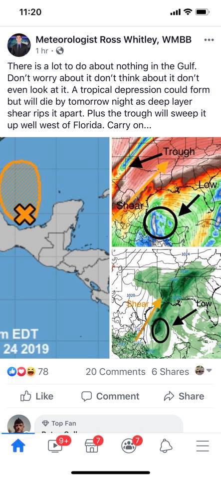
Recon not scheduled to fly down there until tomorrow.....

NOUS42 KNHC 231430
REPRPD
WEATHER RECONNAISSANCE FLIGHTS
CARCAH, NATIONAL HURRICANE CENTER, MIAMI, FL.
1030 AM EDT WED 23 OCTOBER 2019
SUBJECT: TROPICAL CYCLONE PLAN OF THE DAY (TCPOD)
VALID 24/1100Z TO 25/1100Z OCTOBER 2019
TCPOD NUMBER.....19-148

I. ATLANTIC REQUIREMENTS
1. NEGATIVE RECONNAISSANCE REQUIREMENTS.
2. OUTLOOK FOR SUCCEEDING DAY: POSSIBLE INVEST NEAR
24.0N 95.5W FOR 25/1730Z.


ATLANTIC REQUIREMENTS
1. NEGATIVE RECONNAISSANCE REQUIREMENTS.
2. OUTLOOK FOR SUCCEEDING DAY: POSSIBLE INVEST NEAR
24.0N 95.5W FOR 25/1730Z.
1 likes   
NEVER, EVER SAY NEVER in the tropics and weather in general, and most importantly, with life itself!!

________________________________________________________________________________________

Fay 2008 Beryl 2012 Debby 2012 Colin 2016 Hermine 2016 Julia 2016 Matthew 2016 Irma 2017 Dorian 2019

Aric Dunn
Category 5
Category 5
Posts: 21228
Age: 41
Joined: Sun Sep 19, 2004 9:58 pm
Location: Ready for the Chase.
Contact:

Re: ATL: INVEST 97L - Discussion

#30 Postby Aric Dunn » Thu Oct 24, 2019 1:14 pm

12z euro likes it a some more.
0 likes   
Note: If I make a post that is brief. Please refer back to previous posts for the analysis or reasoning. I do not re-write/qoute what my initial post said each time.
If there is nothing before... then just ask :)

Space & Atmospheric Physicist, Embry-Riddle Aeronautical University,
I believe the sky is falling...

User avatar
galaxy401
Category 5
Category 5
Posts: 2299
Age: 29
Joined: Sat Aug 25, 2012 9:04 pm
Location: Casa Grande, Arizona

Re: ATL: INVEST 97L - Discussion

#31 Postby galaxy401 » Thu Oct 24, 2019 1:27 pm

wxman57 wrote:Merges with cold front tomorrow morning - the end.


The NHC implies it will happen tomorrow night so I guess it'll be a waiting game for the next 24 hours. Regardless, the system won't be around for long. Impressed by the quick flare-up though.
0 likes   
Got my eyes on moving right into Hurricane Alley: Florida.

User avatar
SoupBone
Category 5
Category 5
Posts: 3073
Joined: Tue Sep 20, 2005 5:24 pm

Re: ATL: INVEST 97L - Discussion

#32 Postby SoupBone » Thu Oct 24, 2019 1:28 pm

wxman57 wrote:Merges with cold front tomorrow morning - the end.


The cold front appears to be moving a little faster than expected. So that window is even smaller for it to develop?
0 likes   
Personal Forecast Disclaimer:
The posts in this forum are NOT official forecast and should not be used as such. They are just the opinion of the poster and may or may not be backed by sound meteorological data. They are NOT endorsed by any professional institution or storm2k.org. For official information, please refer to the NHC and NWS products.

User avatar
SoupBone
Category 5
Category 5
Posts: 3073
Joined: Tue Sep 20, 2005 5:24 pm

Re: ATL: INVEST 97L - Discussion

#33 Postby SoupBone » Thu Oct 24, 2019 1:29 pm


Booooyyyy, if this were August or September, I'd be worried.
0 likes   
Personal Forecast Disclaimer:
The posts in this forum are NOT official forecast and should not be used as such. They are just the opinion of the poster and may or may not be backed by sound meteorological data. They are NOT endorsed by any professional institution or storm2k.org. For official information, please refer to the NHC and NWS products.

MarioProtVI
Category 2
Category 2
Posts: 671
Age: 22
Joined: Sun Sep 29, 2019 7:33 pm
Location: New Jersey

Re: ATL: INVEST 97L - Discussion

#34 Postby MarioProtVI » Thu Oct 24, 2019 2:03 pm

Funny enough 97L actually shows an inconsistency with classifying systems – Nestor had the same type of circulation that 97 has right now: broad and poorly defined, yet it isn’t classified. Makes me a little skeptical on Nestor too.
1 likes   

caneman
Category 5
Category 5
Posts: 1178
Joined: Fri Sep 05, 2014 5:44 am
Location: Clearwater Beach, Fl

Re: ATL: INVEST 97L - Discussion

#35 Postby caneman » Thu Oct 24, 2019 2:08 pm

ronjon wrote:
chaser1 wrote:
panamatropicwatch wrote:This is from one of our local meteorologist here in Panama City. I hope he is right but I don't know if I would make such a definitive statement at this stage of the game.
http://tropicwatch.info/definitive102420191537z.jpg


For the most part I think he's spot on. I think this is more an interest from a meteorological geek perspective (which naturally does include a good number of us posters here :lol: ). I highly doubt this will present any real risk to Gulf coastal area. Furthermore, after the most recent tropical abortion I doubt that NHC is in any hurry to be trigger happy with this next one (even if it does ultimately become more worthy of T.D. designation tonight or tomorrow).


Although 97L definitely looks warm core and tropical now to start off with - compared to Nestor. While Nestor had no real discernible wind field like a tropical entity, it did spawn a pretty significant (by Florida standards) EF1 tornado that had a long path in Polk County, Florida.


Think they ended up rating it EF2
0 likes   

floridasun78
Category 5
Category 5
Posts: 3755
Joined: Sun May 17, 2009 10:16 pm
Location: miami fl

Re: ATL: INVEST 97L - Discussion

#36 Postby floridasun78 » Thu Oct 24, 2019 3:16 pm

wxman57 wrote:Merges with cold front tomorrow morning - the end.

bring out bone in morning of friday
0 likes   

User avatar
Hammy
Category 5
Category 5
Posts: 5594
Age: 40
Joined: Fri May 25, 2012 5:25 pm
Contact:

Re: ATL: INVEST 97L - Discussion

#37 Postby Hammy » Thu Oct 24, 2019 4:07 pm

MarioProtVI wrote:Funny enough 97L actually shows an inconsistency with classifying systems – Nestor had the same type of circulation that 97 has right now: broad and poorly defined, yet it isn’t classified. Makes me a little skeptical on Nestor too.


Nestor had a developed circulation the entire time--when it was a PTC the issue was multiple circulations (and advisories are not being initiated here because unlike pre-Nestor, there's no need to issue watches or warnings.)

Circulation right now is a curved sharp trough (Nestor on left)

Image
1 likes   
The above post is not official and should not be used as such. It is the opinion of the poster and may or may not be backed by sound meteorological data. It is not endorsed by any professional institution or storm2k.org. For official information, please refer to the NHC and NWS products.

User avatar
johngaltfla
Category 5
Category 5
Posts: 1938
Joined: Sun Jul 10, 2005 9:17 pm
Location: Sarasota County, FL
Contact:

Re: ATL: INVEST 97L - Discussion

#38 Postby johngaltfla » Thu Oct 24, 2019 5:22 pm

Just Die Nestor. I have reservations for Brennan's in New Orleans Saturday Night. I really don't need this. Hit Florida as a thundershower and nothing more please. :shoot:
1 likes   

User avatar
NDG
S2K Supporter
S2K Supporter
Posts: 14934
Joined: Sun Jul 09, 2006 10:14 pm
Location: Orlando, FL

Re: ATL: INVEST 97L - Discussion

#39 Postby NDG » Thu Oct 24, 2019 5:39 pm

This afternoon it still looks to have a broad elongated circulation at the surface as the ASCAT pass earlier this morning showed but pressures continues to fall, buoy 42055 reporting pressure down to 1006mb with wind gusts close to 30 knots, it only has a few hours left before the front sweeps on through.
0 likes   

User avatar
tropicwatch
Category 5
Category 5
Posts: 3205
Age: 60
Joined: Sat Jun 02, 2007 10:01 am
Location: Panama City Florida
Contact:

Re: ATL: INVEST 97L - Discussion

#40 Postby tropicwatch » Thu Oct 24, 2019 6:34 pm

Rotation showing up nicely even on IR.
Image
0 likes   
Tropicwatch


Agnes 72', Eloise 75, Elena 85', Kate 85', Charley 86', Florence 88', Beryl 94', Dean 95', Erin 95', Opal 95', Earl 98', Georges 98', Ivan 2004', Arlene 2005', Dennis 2005', Ida 2009' Debby 2012' Irma 2017' Michael 2018'


Return to “2019”

Who is online

Users browsing this forum: No registered users and 10 guests