CPAC: OLIVIA - Post-Tropical

Moderator: S2k Moderators

Message
Author
User avatar
cycloneye
Admin
Admin
Posts: 139340
Age: 67
Joined: Thu Oct 10, 2002 10:54 am
Location: San Juan, Puerto Rico

Re: EPAC: OLIVIA - Hurricane

#61 Postby cycloneye » Tue Sep 04, 2018 9:48 pm

Hurricane Olivia Discussion Number 17
NWS National Hurricane Center Miami FL EP172018
800 PM PDT Tue Sep 04 2018

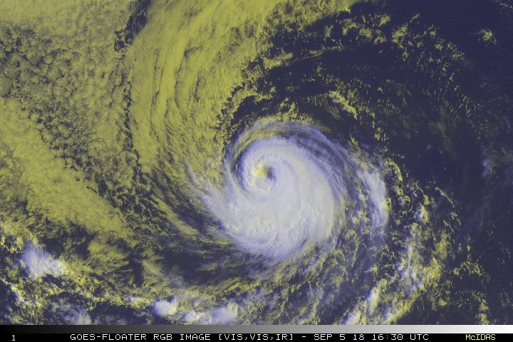
Olivia is displaying a well-defined eye this evening embedded within
a circular central dense overcast. The rapid intensification seems
to have leveled off, since Dvorak estimates have increased only
slightly, but still support a higher wind speed of 110 kt.

Moderate easterly shear, gradually decreasing sea surface
temperatures, and dry air aloft along the forecast track of Olivia
will likely cause the hurricane to slowly weaken by late Wednesday.
The new intensity forecast is slightly higher than the last one,
near or a bit above the model consensus. The forecast is on the
higher side of the guidance because I don't feel particularly
confident about this weakening, given the poor performance of the
guidance for this hurricane so far.

Olivia is moving a little south of due west, 265/10. A
building subtropical ridge over the eastern Pacific is forecast
to cause the hurricane to move westward and west-northwestward
with increasing forward speed during the next several days.
Near the end of the forecast, model guidance is showing a stronger
ridge, and a westward turn is possible. The guidance envelope has
shifted southward on this cycle, and the official NHC prediction is
adjusted in that direction.


FORECAST POSITIONS AND MAX WINDS

INIT 05/0300Z 16.7N 120.1W 110 KT 125 MPH
12H 05/1200Z 16.9N 121.7W 110 KT 125 MPH
24H 06/0000Z 17.5N 124.2W 105 KT 120 MPH
36H 06/1200Z 18.2N 126.8W 100 KT 115 MPH
48H 07/0000Z 19.1N 129.7W 90 KT 105 MPH
72H 08/0000Z 20.9N 135.2W 75 KT 85 MPH
96H 09/0000Z 22.0N 140.5W 65 KT 75 MPH
120H 10/0000Z 22.5N 145.5W 60 KT 70 MPH

$$
Forecaster Blake
0 likes   
Visit the Caribbean-Central America Weather Thread where you can find at first post web cams,radars
and observations from Caribbean basin members Click Here

User avatar
cjrciadt
S2K Supporter
S2K Supporter
Posts: 1615
Joined: Mon Aug 22, 2005 1:11 pm
Location: Kissimmee, FL

Re: EPAC: OLIVIA - Hurricane

#62 Postby cjrciadt » Tue Sep 04, 2018 11:35 pm

0z GFS has Maui Landfall :eek:
0 likes   

User avatar
Kingarabian
S2K Supporter
S2K Supporter
Posts: 15451
Joined: Sat Aug 08, 2009 3:06 am
Location: Honolulu, Hawaii

Re: EPAC: OLIVIA - Hurricane

#63 Postby Kingarabian » Wed Sep 05, 2018 1:48 am

00z Euro Big Island landfall:

Image
1 likes   
RIP Kobe Bryant

SconnieCane
Category 4
Category 4
Posts: 913
Joined: Thu Aug 02, 2018 5:29 pm
Location: Madison, WI

Re: EPAC: OLIVIA - Hurricane

#64 Postby SconnieCane » Wed Sep 05, 2018 3:38 am

Kingarabian wrote:00z Euro Big Island landfall:

Image


The strengthening trend on approach is worrisome, although it depicts rapid weakening after or immediately before landfall.
1 likes   

User avatar
Kingarabian
S2K Supporter
S2K Supporter
Posts: 15451
Joined: Sat Aug 08, 2009 3:06 am
Location: Honolulu, Hawaii

Re: EPAC: OLIVIA - Hurricane

#65 Postby Kingarabian » Wed Sep 05, 2018 4:05 am

SconnieCane wrote:
Kingarabian wrote:00z Euro Big Island landfall:

[img]https://i.imgur.com/NdLA2BS.gif[img]


The strengthening trend on approach is worrisome, although it depicts rapid weakening after or immediately before landfall.


The sweet spot has been between 150W-140W. Just comes down to the placement of the shear axis and if the system gets torn apart or not.
0 likes   
RIP Kobe Bryant

User avatar
Kingarabian
S2K Supporter
S2K Supporter
Posts: 15451
Joined: Sat Aug 08, 2009 3:06 am
Location: Honolulu, Hawaii

Re: EPAC: OLIVIA - Hurricane

#66 Postby Kingarabian » Wed Sep 05, 2018 4:14 am

Hurricane Olivia Discussion Number 18
NWS National Hurricane Center Miami FL EP172018
200 AM PDT Wed Sep 05 2018

GOES-15 imagery and a recent METOP-B AMSU overpass indicate that
Olivia's eyewall has collapsed in the northwest quadrant.
Additionally, the eye temperature has warmed considerably.
Subjective and Objective T-numbers have decreased and support a
lowered intensity of 100 kt for this advisory.

Moderate easterly shear, gradually decreasing sea surface
temperatures, and drier, more stable air in the middle portions of
the atmosphere along the forecast track of the cyclone should
cause the hurricane to continue to slowly weaken. The only
adjustment made to the NHC intensity forecast was a slight increase
at day 4 and 5 to agree more with the consensus intensity guidance.

Olivia's current motion is estimated to be westward, or 275/11 kt.
A building subtropical ridge over the eastern Pacific and to the
north of Olivia is should induce a westward and west-northwestward
with increasing forward speed during the next several days.
Toward the end of the forecast period, global models continue to
show a stronger ridge, and a turn back toward the west is shown
in the advisory. The official forecast is similar to the forecast 6
hours ago, and is close to the NOAA-HCCA and TVCN, which are
typically better-performing guidance models.

FORECAST POSITIONS AND MAX WINDS

INIT 05/0900Z 16.9N 121.2W 100 KT 115 MPH
12H 05/1800Z 17.2N 122.9W 95 KT 110 MPH
24H 06/0600Z 17.8N 125.4W 90 KT 105 MPH
36H 06/1800Z 18.6N 128.0W 85 KT 100 MPH
48H 07/0600Z 19.6N 130.8W 80 KT 90 MPH
72H 08/0600Z 21.3N 136.2W 65 KT 75 MPH
96H 09/0600Z 22.2N 141.5W 60 KT 70 MPH
120H 10/0600Z 22.8N 146.2W 60 KT 70 MPH

$$
Forecaster Roberts
0 likes   
RIP Kobe Bryant

User avatar
Yellow Evan
Professional-Met
Professional-Met
Posts: 15956
Age: 25
Joined: Fri Jul 15, 2011 12:48 pm
Location: Henderson, Nevada/Honolulu, HI
Contact:

Re: EPAC: OLIVIA - Hurricane

#67 Postby Yellow Evan » Wed Sep 05, 2018 8:15 am

05/1200 UTC 17.0N 121.8W T4.5/5.5 OLIVIA -- East Pacific
0 likes   

User avatar
Yellow Evan
Professional-Met
Professional-Met
Posts: 15956
Age: 25
Joined: Fri Jul 15, 2011 12:48 pm
Location: Henderson, Nevada/Honolulu, HI
Contact:

Re: EPAC: OLIVIA - Hurricane

#68 Postby Yellow Evan » Wed Sep 05, 2018 8:19 am

* EAST PACIFIC 2018 SHIPS INTENSITY FORECAST *
* IR SAT DATA AVAILABLE, OHC AVAILABLE *
* OLIVIA EP172018 09/05/18 12 UTC *

TIME (HR) 0 6 12 18 24 36 48 60 72 84 96 108 120
V (KT) NO LAND 95 88 84 83 79 77 72 67 62 59 58 56 55
V (KT) LAND 95 88 84 83 79 77 72 67 62 59 58 56 55
V (KT) LGEM 95 89 85 81 78 72 67 62 58 54 53 53 54
Storm Type TROP TROP TROP TROP TROP TROP TROP TROP TROP TROP TROP TROP TROP

SHEAR (KT) 14 13 12 11 9 9 8 1 1 0 3 3 9
SHEAR ADJ (KT) 2 2 2 0 1 -4 -5 1 -3 0 -2 0 5
SHEAR DIR 38 37 40 42 44 43 44 66 36 296 279 263 265
SST (C) 28.6 28.4 28.1 27.8 27.4 26.3 25.5 25.6 25.4 25.3 25.7 25.8 25.9
POT. INT. (KT) 151 149 146 143 139 128 120 120 118 117 121 121 122
200 MB T (C) -52.3 -52.1 -52.0 -52.3 -52.3 -51.7 -51.9 -51.4 -51.9 -51.4 -51.9 -52.1 -52.5
200 MB VXT (C) 0.5 0.6 0.7 0.8 0.7 0.6 0.7 0.7 1.0 0.8 0.9 0.5 0.5
TH_E DEV (C) 6 5 5 5 5 5 4 4 4 4 4 5 6
700-500 MB RH 51 51 51 50 47 43 39 34 32 33 34 34 35
MODEL VTX (KT) 26 27 27 29 27 29 29 27 25 24 24 23 22
850 MB ENV VOR 36 44 48 55 58 52 74 73 71 60 58 59 50
200 MB DIV 12 32 38 20 6 28 13 10 -2 0 -3 -1 2
700-850 TADV -8 -7 -3 -5 -7 -6 -7 3 -1 4 -1 2 0
LAND (KM) 1313 1391 1476 1542 1611 1758 1954 2071 1815 1544 1276 1047 873
LAT (DEG N) 17.0 17.3 17.5 17.9 18.2 19.1 20.1 21.0 21.6 22.1 22.4 22.7 22.9
LONG(DEG W) 121.8 123.0 124.2 125.5 126.8 129.4 132.3 135.0 137.5 140.2 142.9 145.3 147.2
STM SPEED (KT) 11 12 12 13 13 14 14 13 12 12 12 10 8
HEAT CONTENT 3 5 5 5 3 3 0 0 0 0 0 0 0

FORECAST TRACK FROM OFCI INITIAL HEADING/SPEED (DEG/KT):280/ 11 CX,CY: -10/ 2
T-12 MAX WIND: 110 PRESSURE OF STEERING LEVEL (MB): 515 (MEAN=584)
GOES IR BRIGHTNESS TEMP. STD DEV. 50-200 KM RAD: 14.5 (MEAN=14.5)
% GOES IR PIXELS WITH T < -20 C 50-200 KM RAD: 82.0 (MEAN=65.0)
PRELIM RI PROB (DV .GE. 55 KT IN 48 HR): 0.0

INDIVIDUAL CONTRIBUTIONS TO INTENSITY CHANGE
6 12 18 24 36 48 60 72 84 96 108 120
----------------------------------------------------------
SAMPLE MEAN CHANGE 0. 0. 1. 1. 1. 1. 1. 0. -1. -1. -2. -3.
SST POTENTIAL 0. 1. 1. 0. -4. -10. -17. -24. -29. -32. -35. -35.
VERTICAL SHEAR MAG -2. -4. -5. -5. -5. -4. 0. 4. 7. 8. 9. 9.
VERTICAL SHEAR ADJ 0. 0. 0. 0. 0. 0. 0. 0. 0. 0. 0. 0.
VERTICAL SHEAR DIR 0. 0. 1. 1. 1. 1. 0. -1. -1. -1. -1. 0.
PERSISTENCE -4. -6. -7. -6. -5. -3. -1. 0. 1. 1. 3. 3.
200/250 MB TEMP. 0. 0. 0. 0. 0. 0. 1. 2. 3. 3. 3. 3.
THETA_E EXCESS 0. 0. 0. -1. -1. -2. -3. -3. -4. -4. -5. -5.
700-500 MB RH 0. 0. 0. -1. -1. -3. -4. -5. -5. -5. -6. -6.
MODEL VTX TENDENCY 0. 1. 2. 1. 3. 3. 1. -2. -3. -3. -4. -5.
850 MB ENV VORTICITY 0. 0. 0. 0. 0. -1. -1. -1. -2. -2. -2. -2.
200 MB DIVERGENCE 0. 0. 0. -1. -1. -1. -1. -2. -2. -3. -3. -3.
850-700 T ADVEC 0. 0. 0. 0. 0. 0. -1. -1. -1. -1. -1. -1.
ZONAL STORM MOTION 0. 0. 1. 1. 1. 1. 1. 1. 1. 1. 1. 1.
STEERING LEVEL PRES 0. 0. 0. 0. 0. 0. -1. -1. -1. -1. -1. -1.
DAYS FROM CLIM. PEAK 0. 0. 0. 0. 0. 0. 1. 1. 2. 2. 2. 2.
GOES PREDICTORS -1. -2. -3. -4. -3. -2. -1. -1. 0. 0. 1. 1.
OCEAN HEAT CONTENT 0. 0. 0. -1. -1. 0. -1. 0. 0. 0. 0. 0.
RI POTENTIAL 0. 0. -1. -1. -2. -3. -3. -2. 0. 1. 2. 3.
----------------------------------------------------------
TOTAL CHANGE -7. -11. -12. -16. -18. -23. -28. -33. -36. -37. -39. -40.

CURRENT MAX WIND (KT): 95. LAT, LON: 17.0 121.8

** 2018 E. Pacific RI INDEX EP172018 OLIVIA 09/05/18 12 UTC **
(SHIPS-RII PREDICTOR TABLE for 30 KT OR MORE MAXIMUM WIND INCREASE IN NEXT 24-h)

Predictor Value RI Predictor Range Scaled Value(0-1) % Contribution
POT = MPI-VMAX (KT) : 50.8 40.5 to 149.3 0.09 999.0
12 HR PERSISTENCE (KT) : -15.0 -22.0 to 44.0 0.11 999.0
850-200 MB SHEAR (KT) : 12.2 19.6 to 1.4 0.40 999.0
HEAT CONTENT (KJ/CM2) : 4.2 1.8 to 106.7 0.02 999.0
D200 (10**7s-1) : 21.6 -33.0 to 156.2 0.29 999.0
STD DEV OF IR BR TEMP : 14.5 37.8 to 2.1 0.65 999.0
MAXIMUM WIND (KT) : 95.0 22.5 to 132.0 0.49 999.0
BL DRY-AIR FLUX (W/M2) : 756.6 721.6 to -82.5 0.00 0.0
%area of TPW <45 mm upshear : 0.0 62.3 to 0.0 1.00 999.0
2nd PC OF IR BR TEMP : -0.4 2.2 to -1.9 0.63 999.0

SHIPS Prob RI for 20kt/ 12hr RI threshold= 2% is 0.3 times climatological mean ( 6.1%)
SHIPS Prob RI for 25kt/ 24hr RI threshold= 0% is 0.0 times climatological mean (12.5%)
SHIPS Prob RI for 30kt/ 24hr RI threshold= 0% is 0.0 times climatological mean ( 8.4%)
SHIPS Prob RI for 35kt/ 24hr RI threshold= 0% is 0.0 times climatological mean ( 6.0%)
SHIPS Prob RI for 40kt/ 24hr RI threshold= 0% is 0.0 times climatological mean ( 4.0%)
SHIPS Prob RI for 45kt/ 36hr RI threshold= 0% is 0.0 times climatological mean ( 6.5%)
SHIPS Prob RI for 55kt/ 48hr RI threshold= 0% is 0.0 times climatological mean ( 5.9%)
SHIPS Prob RI for 65kt/ 72hr RI threshold= 0% is 0.0 times climatological mean ( 4.8%)

Matrix of RI probabilities
------------------------------------------------------------------------------
RI (kt / h) | 20/12 | 25/24 | 30/24 | 35/24 | 40/24 | 45/36 | 55/48 |65/72
------------------------------------------------------------------------------
SHIPS-RII: 1.8% 0.0% 0.0% 0.0% 0.0% 0.0% 0.0% 0.0%
Logistic: 0.1% 0.1% 0.1% 0.0% 0.0% 0.0% 0.0% 0.0%
Bayesian: 0.0% 0.0% 0.0% 0.0% 0.0% 0.0% 0.0% 0.0%
Consensus: 0.6% 0.0% 0.0% 0.0% 0.0% 0.0% 0.0% 0.0%
DTOPS: 0.0% 1.0% 0.0% 0.0% 0.0% 0.0% 0.0% 0.0%

## ANNULAR HURRICANE INDEX (AHI) EP172018 OLIVIA 09/05/18 12 UTC ##
## STORM NOT ANNULAR, SCREENING STEP FAILED, NPASS=6 NFAIL=1 ##
## AHI= 0 (AHI OF 100 IS BEST FIT TO ANN. STRUC., 1 IS MARGINAL, 0 IS NOT ANNULAR) ##

CONTRIBUTIONS TO ANNULAR INDEX
0 likes   

User avatar
WAcyclone
Category 1
Category 1
Posts: 349
Joined: Sat Jul 01, 2017 1:56 pm
Location: Perth, Western Australia

Re: EPAC: OLIVIA - Hurricane

#69 Postby WAcyclone » Wed Sep 05, 2018 12:32 pm

Sentinel-3 captured Olivia yesterday at 1551z while the storm's intensity was around 90 knots according to the NHC:

Image

Close-up of the eye:

Image
4 likes   

supercane4867
Category 5
Category 5
Posts: 4966
Joined: Wed Nov 14, 2012 10:43 am

Re: EPAC: OLIVIA - Hurricane

#70 Postby supercane4867 » Wed Sep 05, 2018 1:35 pm

The recent two runs of EC insist on the strong ridging that will push Olivia southwestward toward Hawaii.
0 likes   

supercane4867
Category 5
Category 5
Posts: 4966
Joined: Wed Nov 14, 2012 10:43 am

Re: EPAC: OLIVIA - Hurricane

#71 Postby supercane4867 » Wed Sep 05, 2018 1:56 pm

12z EC has Olivia crossing Oahu - Kauai as a week TS. Probably won't be much of a storm by then as always.
0 likes   

User avatar
Kingarabian
S2K Supporter
S2K Supporter
Posts: 15451
Joined: Sat Aug 08, 2009 3:06 am
Location: Honolulu, Hawaii

Re: EPAC: OLIVIA - Hurricane

#72 Postby Kingarabian » Wed Sep 05, 2018 2:21 pm

supercane4867 wrote:12z EC has Olivia crossing Oahu - Kauai as a week TS. Probably won't be much of a storm by then as always.


Looking at the high resolution Euro, it appears to have a 996mb TS hit on Molokai with 50kt sustained winds and 70kt gusts, and a 999mb TS hit on Oahu with almost the same conditions.

I'm not paying much attention to the intensity forecasts this far out other than hoping it gets ripped apart like how Lane did. It comes down to where the shear axis is situated, which the models will struggle to forecast this far out. But the fact that the models and their ensembles continue to cluster over a Hawaii hit is concerning. It's no secret that Honolulu is not prepared to handle a Cat.1 hurricane hit (almost close to what the Euro is showing), while the GFS shows another insane amount of rainfall for the Big Island.
0 likes   
RIP Kobe Bryant

User avatar
Kingarabian
S2K Supporter
S2K Supporter
Posts: 15451
Joined: Sat Aug 08, 2009 3:06 am
Location: Honolulu, Hawaii

Re: EPAC: OLIVIA - Hurricane

#73 Postby Kingarabian » Wed Sep 05, 2018 2:35 pm

12z Euro:
Image

12z GFS:
Image
0 likes   
RIP Kobe Bryant

User avatar
Kingarabian
S2K Supporter
S2K Supporter
Posts: 15451
Joined: Sat Aug 08, 2009 3:06 am
Location: Honolulu, Hawaii

Re: EPAC: OLIVIA - Hurricane

#74 Postby Kingarabian » Wed Sep 05, 2018 2:55 pm

The UKMET has consistently kept this north of Hawaii but some of its members are now showing tracks that hit Hawaii:
Image
0 likes   
RIP Kobe Bryant

User avatar
cycloneye
Admin
Admin
Posts: 139340
Age: 67
Joined: Thu Oct 10, 2002 10:54 am
Location: San Juan, Puerto Rico

Re: EPAC: OLIVIA - Hurricane

#75 Postby cycloneye » Wed Sep 05, 2018 3:52 pm

Hurricane Olivia Discussion Number 20
NWS National Hurricane Center Miami FL EP172018
200 PM PDT Wed Sep 05 2018

While satellite imagery shows that the erosion of the eyewall
convection is less than seen 6 h ago, the various satellite
intensity estimates indicate that Olivia continues to slowly
weaken. Based on a blend of these estimates, the initial intensity
is reduced to 85 kt. Recent satellite data indicate that the wind
and wave fields associated with Olivia are larger than previously
analyzed, and they have been revised for this advisory.

Ongoing moderate easterly shear over Olivia should diminish during
the next 12 h or so. After that, the major influences on the
intensity should be gradually decreasing sea surface temperatures
along the forecast track and entrainment of air that gets
progressively drier through the forecast period. The intensity
guidance is still in good agreement that Olivia should weaken
through the forecast period, and the new intensity forecast again
follows this trend. Overall, the intensity forecast is in best
agreement with the SHIPS model and the IVCN intensity consensus.

The initial motion is now 285/11. A large deep-layer ridge seen in
water vapor imagery to the north of Olivia should steer the
hurricane generally west-northwestward for the next 2-3 days.
After that time, the ridge builds westward to the northeast and
north of the Hawaiian Islands, and this should cause Olivia to
turn westward. The track guidance remains in good agreement with
this scenario, although the UKMET and the UKMET ensemble mean are
still showing a motion to the north of the other models. The new
forecast track is similar to the previous track, and it generally
lies between the track consensus model TVCN and the HFIP corrected
consensus model.


FORECAST POSITIONS AND MAX WINDS

INIT 05/2100Z 17.3N 123.5W 85 KT 100 MPH
12H 06/0600Z 17.9N 125.3W 80 KT 90 MPH
24H 06/1800Z 18.6N 127.9W 80 KT 90 MPH
36H 07/0600Z 19.5N 130.6W 75 KT 85 MPH
48H 07/1800Z 20.4N 133.3W 70 KT 80 MPH
72H 08/1800Z 21.5N 138.5W 60 KT 70 MPH
96H 09/1800Z 22.0N 143.5W 55 KT 65 MPH
120H 10/1800Z 22.5N 148.0W 55 KT 65 MPH

$$
Forecaster Beven
1 likes   
Visit the Caribbean-Central America Weather Thread where you can find at first post web cams,radars
and observations from Caribbean basin members Click Here

supercane4867
Category 5
Category 5
Posts: 4966
Joined: Wed Nov 14, 2012 10:43 am

Re: EPAC: OLIVIA - Hurricane

#76 Postby supercane4867 » Wed Sep 05, 2018 5:50 pm

18z GFS trying to do a Madeline 16 on Big Island
0 likes   

User avatar
Kingarabian
S2K Supporter
S2K Supporter
Posts: 15451
Joined: Sat Aug 08, 2009 3:06 am
Location: Honolulu, Hawaii

Re: EPAC: OLIVIA - Hurricane

#77 Postby Kingarabian » Wed Sep 05, 2018 5:59 pm

Another run, and another track towards Hawaii on this 18z GFS run:

Image

So it's becoming clear that there will be a monster ridge forming in 96 hours between the central and eastern Pacific. Depending on the location of Olivia will determine which Island will be under the gun.

Also don't take the intensity predictions too seriously at this stage. Lot's of variable come into play, and if Olivia is going to affect the islands it could easily be anything between a weak TS or a Cat.1-Cat.2.
0 likes   
RIP Kobe Bryant

Ntxw
Storm2k Moderator
Storm2k Moderator
Posts: 21523
Joined: Wed Oct 21, 2009 6:34 pm
Location: DFW, Texas

Re: EPAC: OLIVIA - Hurricane

#78 Postby Ntxw » Wed Sep 05, 2018 7:13 pm

Recovered some going poleward

Image
2 likes   
The above post and any post by Ntxw is NOT an official forecast and should not be used as such. It is just the opinion of the poster and may or may not be backed by sound meteorological data. It is NOT endorsed by any professional institution including Storm2k. For official information, please refer to NWS products.

  Help support Storm2K!
Help Support Storm2K

User avatar
cycloneye
Admin
Admin
Posts: 139340
Age: 67
Joined: Thu Oct 10, 2002 10:54 am
Location: San Juan, Puerto Rico

Re: EPAC: OLIVIA - Hurricane

#79 Postby cycloneye » Wed Sep 05, 2018 9:38 pm

Hurricane Olivia Discussion Number 21
NWS National Hurricane Center Miami FL EP172018
800 PM PDT Wed Sep 05 2018

Olivia continues to have a large and distinct eye, but the
surrounding convection has not changed in the past 6 h or so. Dvorak
numbers are steady, and a blend of objective and subjective
estimates yield an initial intensity of 85 kt. The shear is not a
problem for Olivia since it is forecast to remain low through the
entire 5-day period. However, in about a day, the SSTs along
Olivia's track will decrease resulting in a gradual weakening
of the cyclone. The NHC intensity forecast is similar to the
previous one, and follows the intensity consensus.

There has been no change in track, and Olivia is still moving
toward the west-northwest or 285 degrees at 12 kt. The subtropical
ridge is anchored north of the hurricane, and this flow pattern
should continue to steer Olivia on the same general track for he
next 5 days. By the end of the forecast period, the ridge is
expected to expand westward, forcing the cyclone to move westward.
Track models are in an excellent agreement, and the guidance
envelope remains tightly clustered for the next 3 days. After
that time, although the envelope widens a little bit, models still
indicate a westward-moving cyclone. The NHC forecast is in the
middle of the envelope and very close to the multi-model aids.

FORECAST POSITIONS AND MAX WINDS

INIT 06/0300Z 17.7N 124.6W 85 KT 100 MPH
12H 06/1200Z 18.2N 126.5W 80 KT 90 MPH
24H 07/0000Z 18.9N 129.1W 80 KT 90 MPH
36H 07/1200Z 20.0N 132.0W 75 KT 85 MPH
48H 08/0000Z 20.8N 134.5W 70 KT 80 MPH
72H 09/0000Z 21.8N 139.7W 60 KT 70 MPH
96H 10/0000Z 22.0N 144.5W 55 KT 65 MPH
120H 11/0000Z 22.0N 149.0W 55 KT 65 MPH

$$
Forecaster Avila
0 likes   
Visit the Caribbean-Central America Weather Thread where you can find at first post web cams,radars
and observations from Caribbean basin members Click Here

User avatar
Kingarabian
S2K Supporter
S2K Supporter
Posts: 15451
Joined: Sat Aug 08, 2009 3:06 am
Location: Honolulu, Hawaii

Re: EPAC: OLIVIA - Hurricane

#80 Postby Kingarabian » Wed Sep 05, 2018 10:10 pm

Olivia is developing a feeder band similar to Lane's when it first became a major:

Image
0 likes   
RIP Kobe Bryant


Return to “2018”

Who is online

Users browsing this forum: No registered users and 2 guests