* EAST PACIFIC 2018 SHIPS INTENSITY FORECAST *
* IR SAT DATA AVAILABLE, OHC AVAILABLE *
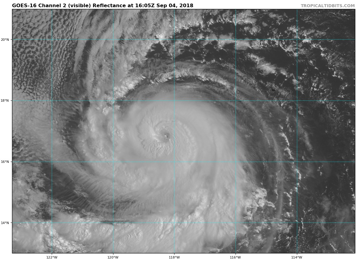
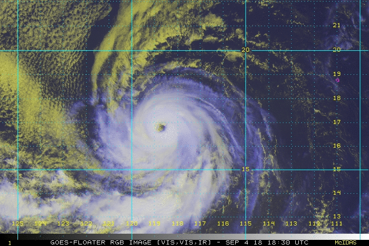
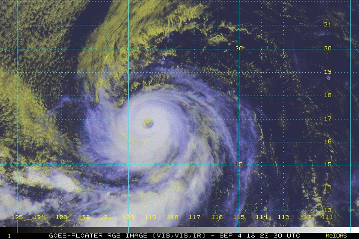
* OLIVIA EP172018 09/04/18 12 UTC *
TIME (HR) 0 6 12 18 24 36 48 60 72 84 96 108 120
V (KT) NO LAND 90 97 99 99 97 91 85 75 69 63 54 48 44
V (KT) LAND 90 97 99 99 97 91 85 75 69 63 54 48 44
V (KT) LGEM 90 98 102 102 100 91 81 72 62 55 49 44 42
Storm Type TROP TROP TROP TROP TROP TROP TROP TROP TROP TROP TROP TROP TROP
SHEAR (KT) 13 12 11 16 18 14 11 11 11 3 5 3 5
SHEAR ADJ (KT) 4 3 5 4 4 2 1 0 -4 -2 -5 -5 -5
SHEAR DIR 50 54 52 40 37 51 44 33 27 77 48 106 300
SST (C) 29.1 29.1 28.9 28.7 28.5 27.8 27.0 25.8 25.3 25.3 25.1 25.1 25.4
POT. INT. (KT) 156 156 154 152 150 143 135 123 118 117 115 115 118
200 MB T (C) -52.8 -52.6 -52.1 -52.1 -52.1 -51.7 -51.9 -51.5 -51.8 -51.6 -52.1 -52.1 -52.6
200 MB VXT (C) 0.6 0.6 0.6 0.7 0.9 1.0 0.9 0.9 1.0 0.9 1.1 0.7 0.5
TH_E DEV (C) 7 6 7 6 6 5 5 4 4 4 3 4 4
700-500 MB RH 57 56 53 52 52 50 48 44 41 38 40 40 40
MODEL VTX (KT) 25 26 27 27 28 29 31 28 27 26 23 22 20
850 MB ENV VOR 19 32 35 37 33 49 73 65 59 53 26 13 8
200 MB DIV 6 17 14 7 14 30 15 17 3 -1 7 2 0
700-850 TADV -1 -1 -2 -5 -6 -2 -8 -4 -8 1 -4 3 1
LAND (KM) 1032 1091 1157 1221 1292 1451 1589 1763 1968 2011 1751 1509 1282
LAT (DEG N) 17.0 17.1 17.1 17.3 17.5 18.1 18.8 19.7 20.7 21.6 22.3 22.9 23.3
LONG(DEG W) 117.7 118.8 119.8 120.9 122.0 124.5 127.1 129.9 132.8 135.6 138.2 140.7 143.1
STM SPEED (KT) 10 10 10 11 12 12 13 14 14 13 12 11 11
HEAT CONTENT 9 10 3 2 6 6 3 1 0 0 0 0 0
FORECAST TRACK FROM OFCI INITIAL HEADING/SPEED (DEG/KT):275/ 10 CX,CY: -9/ 1
T-12 MAX WIND: 65 PRESSURE OF STEERING LEVEL (MB): 527 (MEAN=584)
GOES IR BRIGHTNESS TEMP. STD DEV. 50-200 KM RAD: 10.5 (MEAN=14.5)
% GOES IR PIXELS WITH T < -20 C 50-200 KM RAD: 95.0 (MEAN=65.0)
PRELIM RI PROB (DV .GE. 55 KT IN 48 HR): 0.0
INDIVIDUAL CONTRIBUTIONS TO INTENSITY CHANGE
6 12 18 24 36 48 60 72 84 96 108 120
----------------------------------------------------------
SAMPLE MEAN CHANGE 0. 0. 1. 1. 1. 1. 1. 0. -1. -1. -2. -3.
SST POTENTIAL 0. 1. 2. 2. 1. -4. -11. -17. -22. -26. -28. -29.
VERTICAL SHEAR MAG -1. -3. -5. -6. -8. -7. -5. -3. 0. 2. 3. 3.
VERTICAL SHEAR ADJ 0. 0. 0. 0. -1. -1. 0. 0. 0. 0. 0. 0.
VERTICAL SHEAR DIR 0. 1. 1. 1. 2. 2. 2. 1. 0. -1. -3. -2.
PERSISTENCE 7. 9. 10. 9. 6. 4. 1. -1. -1. -2. -4. -4.
200/250 MB TEMP. 0. 0. 0. 0. 0. 0. 1. 2. 3. 3. 3. 3.
THETA_E EXCESS 0. 0. 0. 0. 0. -1. -2. -2. -3. -4. -4. -5.
700-500 MB RH 0. 0. 0. 0. -1. -2. -2. -3. -4. -4. -4. -5.
MODEL VTX TENDENCY 0. 1. 2. 3. 4. 6. 3. 4. 1. -2. -3. -6.
850 MB ENV VORTICITY 0. 0. 0. 0. 0. 0. -1. -1. -1. -1. -1. -1.
200 MB DIVERGENCE 0. 0. -1. -1. -1. -1. -1. -2. -3. -3. -3. -3.
850-700 T ADVEC 0. 0. 0. 0. 0. 0. 0. -1. -1. -1. -1. -1.
ZONAL STORM MOTION 0. 0. 0. 1. 1. 1. 1. 1. 1. 0. 0. 0.
STEERING LEVEL PRES 0. 0. 0. 0. 0. 0. 0. -1. -1. -1. -1. -1.
DAYS FROM CLIM. PEAK 0. 0. 0. 0. 0. 0. 1. 1. 2. 2. 2. 2.
GOES PREDICTORS 0. 0. 0. 0. 1. 1. 2. 1. 1. 1. 2. 2.
OCEAN HEAT CONTENT 0. 0. 0. 0. 0. 0. -1. 0. 0. 0. 0. 0.
RI POTENTIAL 0. 0. -1. -1. -2. -3. -3. -2. 0. 1. 2. 3.
----------------------------------------------------------
TOTAL CHANGE 7. 9. 9. 7. 1. -5. -15. -21. -27. -36. -42. -46.
CURRENT MAX WIND (KT): 90. LAT, LON: 17.0 117.7
** 2018 E. Pacific RI INDEX EP172018 OLIVIA 09/04/18 12 UTC **
(SHIPS-RII PREDICTOR TABLE for 30 KT OR MORE MAXIMUM WIND INCREASE IN NEXT 24-h)
Predictor Value RI Predictor Range Scaled Value(0-1) % Contribution
POT = MPI-VMAX (KT) : 63.5 40.5 to 149.3 0.21 1.5
12 HR PERSISTENCE (KT) : 25.0 -22.0 to 44.0 0.71 5.9
850-200 MB SHEAR (KT) : 14.3 19.6 to 1.4 0.29 1.9
HEAT CONTENT (KJ/CM2) : 6.0 1.8 to 106.7 0.04 0.2
D200 (10**7s-1) : 11.6 -33.0 to 156.2 0.24 1.4
STD DEV OF IR BR TEMP : 10.5 37.8 to 2.1 0.76 3.7
MAXIMUM WIND (KT) : 90.0 22.5 to 132.0 0.56 2.6
BL DRY-AIR FLUX (W/M2) : 632.2 721.6 to -82.5 0.11 -0.5
%area of TPW <45 mm upshear : 0.0 62.3 to 0.0 1.00 0.5
2nd PC OF IR BR TEMP : -0.5 2.2 to -1.9 0.65 0.5
SHIPS Prob RI for 20kt/ 12hr RI threshold= 21% is 3.4 times climatological mean ( 6.1%)
SHIPS Prob RI for 25kt/ 24hr RI threshold= 22% is 1.5 times climatological mean (12.5%)
SHIPS Prob RI for 30kt/ 24hr RI threshold= 18% is 2.6 times climatological mean ( 8.4%)
SHIPS Prob RI for 35kt/ 24hr RI threshold= 16% is 2.6 times climatological mean ( 6.0%)
SHIPS Prob RI for 40kt/ 24hr RI threshold= 12% is 2.9 times climatological mean ( 4.0%)
SHIPS Prob RI for 45kt/ 36hr RI threshold= 0% is 0.0 times climatological mean ( 6.5%)
SHIPS Prob RI for 55kt/ 48hr RI threshold= 0% is 0.0 times climatological mean ( 5.9%)
SHIPS Prob RI for 65kt/ 72hr RI threshold= 0% is 0.0 times climatological mean ( 4.8%)
Matrix of RI probabilities
------------------------------------------------------------------------------
RI (kt / h) | 20/12 | 25/24 | 30/24 | 35/24 | 40/24 | 45/36 | 55/48 |65/72
------------------------------------------------------------------------------
SHIPS-RII: 20.9% 22.5% 17.7% 15.8% 11.5% 0.0% 0.0% 0.0%
Logistic: 9.2% 3.9% 3.5% 2.3% 0.9% 0.9% 0.5% 0.0%
Bayesian: 1.1% 0.4% 0.0% 0.0% 0.0% 0.0% 0.0% 0.0%
Consensus: 10.4% 8.9% 7.1% 6.1% 4.1% 0.3% 0.2% 0.0%
DTOPS: 7.0% 8.0% 4.0% 3.0% 1.0% 0.0% 0.0% 0.0%
## ANNULAR HURRICANE INDEX (AHI) EP172018 OLIVIA 09/04/18 12 UTC ##
## STORM NOT ANNULAR, SCREENING STEP FAILED, NPASS=6 NFAIL=1 ##
## AHI= 0 (AHI OF 100 IS BEST FIT TO ANN. STRUC., 1 IS MARGINAL, 0 IS NOT ANNULAR) ##
CONTRIBUTIONS TO ANNULAR INDEX
* IR SAT DATA AVAILABLE, OHC AVAILABLE *
* OLIVIA EP172018 09/04/18 12 UTC *
TIME (HR) 0 6 12 18 24 36 48 60 72 84 96 108 120
V (KT) NO LAND 90 97 99 99 97 91 85 75 69 63 54 48 44
V (KT) LAND 90 97 99 99 97 91 85 75 69 63 54 48 44
V (KT) LGEM 90 98 102 102 100 91 81 72 62 55 49 44 42
Storm Type TROP TROP TROP TROP TROP TROP TROP TROP TROP TROP TROP TROP TROP
SHEAR (KT) 13 12 11 16 18 14 11 11 11 3 5 3 5
SHEAR ADJ (KT) 4 3 5 4 4 2 1 0 -4 -2 -5 -5 -5
SHEAR DIR 50 54 52 40 37 51 44 33 27 77 48 106 300
SST (C) 29.1 29.1 28.9 28.7 28.5 27.8 27.0 25.8 25.3 25.3 25.1 25.1 25.4
POT. INT. (KT) 156 156 154 152 150 143 135 123 118 117 115 115 118
200 MB T (C) -52.8 -52.6 -52.1 -52.1 -52.1 -51.7 -51.9 -51.5 -51.8 -51.6 -52.1 -52.1 -52.6
200 MB VXT (C) 0.6 0.6 0.6 0.7 0.9 1.0 0.9 0.9 1.0 0.9 1.1 0.7 0.5
TH_E DEV (C) 7 6 7 6 6 5 5 4 4 4 3 4 4
700-500 MB RH 57 56 53 52 52 50 48 44 41 38 40 40 40
MODEL VTX (KT) 25 26 27 27 28 29 31 28 27 26 23 22 20
850 MB ENV VOR 19 32 35 37 33 49 73 65 59 53 26 13 8
200 MB DIV 6 17 14 7 14 30 15 17 3 -1 7 2 0
700-850 TADV -1 -1 -2 -5 -6 -2 -8 -4 -8 1 -4 3 1
LAND (KM) 1032 1091 1157 1221 1292 1451 1589 1763 1968 2011 1751 1509 1282
LAT (DEG N) 17.0 17.1 17.1 17.3 17.5 18.1 18.8 19.7 20.7 21.6 22.3 22.9 23.3
LONG(DEG W) 117.7 118.8 119.8 120.9 122.0 124.5 127.1 129.9 132.8 135.6 138.2 140.7 143.1
STM SPEED (KT) 10 10 10 11 12 12 13 14 14 13 12 11 11
HEAT CONTENT 9 10 3 2 6 6 3 1 0 0 0 0 0
FORECAST TRACK FROM OFCI INITIAL HEADING/SPEED (DEG/KT):275/ 10 CX,CY: -9/ 1
T-12 MAX WIND: 65 PRESSURE OF STEERING LEVEL (MB): 527 (MEAN=584)
GOES IR BRIGHTNESS TEMP. STD DEV. 50-200 KM RAD: 10.5 (MEAN=14.5)
% GOES IR PIXELS WITH T < -20 C 50-200 KM RAD: 95.0 (MEAN=65.0)
PRELIM RI PROB (DV .GE. 55 KT IN 48 HR): 0.0
INDIVIDUAL CONTRIBUTIONS TO INTENSITY CHANGE
6 12 18 24 36 48 60 72 84 96 108 120
----------------------------------------------------------
SAMPLE MEAN CHANGE 0. 0. 1. 1. 1. 1. 1. 0. -1. -1. -2. -3.
SST POTENTIAL 0. 1. 2. 2. 1. -4. -11. -17. -22. -26. -28. -29.
VERTICAL SHEAR MAG -1. -3. -5. -6. -8. -7. -5. -3. 0. 2. 3. 3.
VERTICAL SHEAR ADJ 0. 0. 0. 0. -1. -1. 0. 0. 0. 0. 0. 0.
VERTICAL SHEAR DIR 0. 1. 1. 1. 2. 2. 2. 1. 0. -1. -3. -2.
PERSISTENCE 7. 9. 10. 9. 6. 4. 1. -1. -1. -2. -4. -4.
200/250 MB TEMP. 0. 0. 0. 0. 0. 0. 1. 2. 3. 3. 3. 3.
THETA_E EXCESS 0. 0. 0. 0. 0. -1. -2. -2. -3. -4. -4. -5.
700-500 MB RH 0. 0. 0. 0. -1. -2. -2. -3. -4. -4. -4. -5.
MODEL VTX TENDENCY 0. 1. 2. 3. 4. 6. 3. 4. 1. -2. -3. -6.
850 MB ENV VORTICITY 0. 0. 0. 0. 0. 0. -1. -1. -1. -1. -1. -1.
200 MB DIVERGENCE 0. 0. -1. -1. -1. -1. -1. -2. -3. -3. -3. -3.
850-700 T ADVEC 0. 0. 0. 0. 0. 0. 0. -1. -1. -1. -1. -1.
ZONAL STORM MOTION 0. 0. 0. 1. 1. 1. 1. 1. 1. 0. 0. 0.
STEERING LEVEL PRES 0. 0. 0. 0. 0. 0. 0. -1. -1. -1. -1. -1.
DAYS FROM CLIM. PEAK 0. 0. 0. 0. 0. 0. 1. 1. 2. 2. 2. 2.
GOES PREDICTORS 0. 0. 0. 0. 1. 1. 2. 1. 1. 1. 2. 2.
OCEAN HEAT CONTENT 0. 0. 0. 0. 0. 0. -1. 0. 0. 0. 0. 0.
RI POTENTIAL 0. 0. -1. -1. -2. -3. -3. -2. 0. 1. 2. 3.
----------------------------------------------------------
TOTAL CHANGE 7. 9. 9. 7. 1. -5. -15. -21. -27. -36. -42. -46.
CURRENT MAX WIND (KT): 90. LAT, LON: 17.0 117.7
** 2018 E. Pacific RI INDEX EP172018 OLIVIA 09/04/18 12 UTC **
(SHIPS-RII PREDICTOR TABLE for 30 KT OR MORE MAXIMUM WIND INCREASE IN NEXT 24-h)
Predictor Value RI Predictor Range Scaled Value(0-1) % Contribution
POT = MPI-VMAX (KT) : 63.5 40.5 to 149.3 0.21 1.5
12 HR PERSISTENCE (KT) : 25.0 -22.0 to 44.0 0.71 5.9
850-200 MB SHEAR (KT) : 14.3 19.6 to 1.4 0.29 1.9
HEAT CONTENT (KJ/CM2) : 6.0 1.8 to 106.7 0.04 0.2
D200 (10**7s-1) : 11.6 -33.0 to 156.2 0.24 1.4
STD DEV OF IR BR TEMP : 10.5 37.8 to 2.1 0.76 3.7
MAXIMUM WIND (KT) : 90.0 22.5 to 132.0 0.56 2.6
BL DRY-AIR FLUX (W/M2) : 632.2 721.6 to -82.5 0.11 -0.5
%area of TPW <45 mm upshear : 0.0 62.3 to 0.0 1.00 0.5
2nd PC OF IR BR TEMP : -0.5 2.2 to -1.9 0.65 0.5
SHIPS Prob RI for 20kt/ 12hr RI threshold= 21% is 3.4 times climatological mean ( 6.1%)
SHIPS Prob RI for 25kt/ 24hr RI threshold= 22% is 1.5 times climatological mean (12.5%)
SHIPS Prob RI for 30kt/ 24hr RI threshold= 18% is 2.6 times climatological mean ( 8.4%)
SHIPS Prob RI for 35kt/ 24hr RI threshold= 16% is 2.6 times climatological mean ( 6.0%)
SHIPS Prob RI for 40kt/ 24hr RI threshold= 12% is 2.9 times climatological mean ( 4.0%)
SHIPS Prob RI for 45kt/ 36hr RI threshold= 0% is 0.0 times climatological mean ( 6.5%)
SHIPS Prob RI for 55kt/ 48hr RI threshold= 0% is 0.0 times climatological mean ( 5.9%)
SHIPS Prob RI for 65kt/ 72hr RI threshold= 0% is 0.0 times climatological mean ( 4.8%)
Matrix of RI probabilities
------------------------------------------------------------------------------
RI (kt / h) | 20/12 | 25/24 | 30/24 | 35/24 | 40/24 | 45/36 | 55/48 |65/72
------------------------------------------------------------------------------
SHIPS-RII: 20.9% 22.5% 17.7% 15.8% 11.5% 0.0% 0.0% 0.0%
Logistic: 9.2% 3.9% 3.5% 2.3% 0.9% 0.9% 0.5% 0.0%
Bayesian: 1.1% 0.4% 0.0% 0.0% 0.0% 0.0% 0.0% 0.0%
Consensus: 10.4% 8.9% 7.1% 6.1% 4.1% 0.3% 0.2% 0.0%
DTOPS: 7.0% 8.0% 4.0% 3.0% 1.0% 0.0% 0.0% 0.0%
## ANNULAR HURRICANE INDEX (AHI) EP172018 OLIVIA 09/04/18 12 UTC ##
## STORM NOT ANNULAR, SCREENING STEP FAILED, NPASS=6 NFAIL=1 ##
## AHI= 0 (AHI OF 100 IS BEST FIT TO ANN. STRUC., 1 IS MARGINAL, 0 IS NOT ANNULAR) ##
CONTRIBUTIONS TO ANNULAR INDEX