ATL: INVEST 99L - Discussion
Moderator: S2k Moderators
-
- Category 5
- Posts: 3950
- Age: 27
- Joined: Mon Aug 17, 2015 4:16 pm
- Location: Ft. Lauderdale, Florida
Re: ATL: INVEST 99L - Discussion
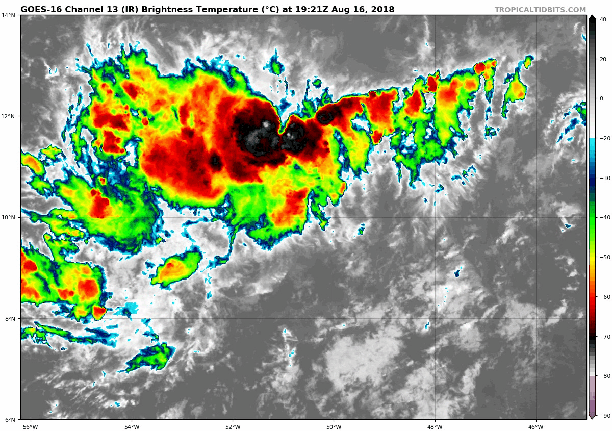
Following the blow up of convection it appears to have a WNW turn now.
0 likes
The posts in this forum are NOT official forecasts and should not be used as such. They are just the opinion of the poster and may or may not be backed by sound meteorological data. They are NOT endorsed by any professional institution or STORM2K. For official information, please refer to products from the NHC and NWS.
Model Runs Cheat Sheet:
GFS (5:30 AM/PM, 11:30 AM/PM)
HWRF, GFDL, UKMET, NAVGEM (6:30-8:00 AM/PM, 12:30-2:00 AM/PM)
ECMWF (1:45 AM/PM)
TCVN is a weighted averaged
-
- Category 1
- Posts: 252
- Joined: Fri May 11, 2018 9:20 pm
Re: ATL: INVEST 99L - Discussion
Just eyeballing maybe a surface low has been slowly organizing .
0 likes
- cycloneye
- Admin
- Posts: 139493
- Age: 67
- Joined: Thu Oct 10, 2002 10:54 am
- Location: San Juan, Puerto Rico
Re: ATL: INVEST 99L - Discussion
A large area of poorly-organized showers and thunderstorms located
about 600 miles east-southeast of the Windward Islands is associated
with a tropical wave. Some development of this system is possible
over the next couple of days while it moves west-northwestward at
around 15 mph toward the Windward Islands. By late Saturday,
unfavorable environmental conditions should limit the chances for
additional development while the system moves over the eastern
Caribbean Sea. Regardless of development, this system is likely to
bring locally heavy rainfall to portions of the Lesser Antilles on
Friday and Saturday.
* Formation chance through 48 hours...low...20 percent.
* Formation chance through 5 days...low...20 percent.
4 likes
Visit the Caribbean-Central America Weather Thread where you can find at first post web cams,radars
and observations from Caribbean basin members Click Here
-
- Category 5
- Posts: 3950
- Age: 27
- Joined: Mon Aug 17, 2015 4:16 pm
- Location: Ft. Lauderdale, Florida
Re: ATL: INVEST 99L - Discussion
It's struggling this evening, lost a lot of the convection it had from this afternoon.
1 likes
The posts in this forum are NOT official forecasts and should not be used as such. They are just the opinion of the poster and may or may not be backed by sound meteorological data. They are NOT endorsed by any professional institution or STORM2K. For official information, please refer to products from the NHC and NWS.
Model Runs Cheat Sheet:
GFS (5:30 AM/PM, 11:30 AM/PM)
HWRF, GFDL, UKMET, NAVGEM (6:30-8:00 AM/PM, 12:30-2:00 AM/PM)
ECMWF (1:45 AM/PM)
TCVN is a weighted averaged
Re: ATL: INVEST 99L - Discussion
Center of apparent circulation is moving WNW now closer to 10N -56w.
The convection is on the wane tonight but will likely flare up again so Barbados south could see some flash flood rains. The wind shear can pick up a lot of moisture from even a shallow surface low. Official forecast is still calling for shear Saturday, Belize might be the next area of concern if the low surface pressure persists to the western Caribbean?
0 likes
Re: ATL: INVEST 99L - Discussion
TheStormExpert wrote:Hypercane_Kyle wrote:Certainly looks ominous enough, but nonexistent model support from operational/ensemble members. Not likely to be anything more than a tropical wave.
Models have been actually doing very poorly this season in regards to picking up on every Atlantic system we’ve had to date.
IHMO After some of the model updates over last couple years, seems the global models are not creating as many ‘’model-storms’ but also aren’t picking up on some the smaller and less obvious systems. That being said I’d be surprised if this system does much, some needed rain?
0 likes
The following post is NOT an official forecast and should not be used as such. It is just the opinion of the poster and may or may not be backed by sound meteorological data. It is NOT endorsed by any professional institution including storm2k.org For Official Information please refer to the NHC and NWS products.
- cycloneye
- Admin
- Posts: 139493
- Age: 67
- Joined: Thu Oct 10, 2002 10:54 am
- Location: San Juan, Puerto Rico
Re: ATL: INVEST 99L - Discussion
Down to 10%.
A tropical wave located about 400 miles east-southeast of the
Windward Islands continues to produce disorganized showers and
thunderstorms. Environmental conditions are only marginally
conducive, and significant development of this system is not
anticipated. This disturbance is moving westward at about 15 mph
and is forecast to move through the Windward Islands on Saturday,
where it could bring locally heavy rainfall to portions of the
Lesser Antilles during the next couple of days.
* Formation chance through 48 hours...low...10 percent.
* Formation chance through 5 days...low...10 percent.
Forecaster Brown
3 likes
Visit the Caribbean-Central America Weather Thread where you can find at first post web cams,radars
and observations from Caribbean basin members Click Here
Re: ATL: INVEST 99L - Discussion
99L did the usual pulsing the past couple of days but it never really consolidated well enough to really take off.
1 likes
The above post and any post by Ntxw is NOT an official forecast and should not be used as such. It is just the opinion of the poster and may or may not be backed by sound meteorological data. It is NOT endorsed by any professional institution including Storm2k. For official information, please refer to NWS products.
-
- Category 5
- Posts: 3755
- Joined: Sun May 17, 2009 10:16 pm
- Location: miami fl
Re: ATL: INVEST 99L - Discussion
this invest never got big push to be td it try but no luck islands will get good rain for weekend
0 likes
-
- Tropical Storm
- Posts: 190
- Joined: Fri Jul 07, 2017 7:46 pm
Re: ATL: INVEST 99L - Discussion
502
ABNT20 KNHC 172311
TWOAT
Tropical Weather Outlook
NWS National Hurricane Center Miami FL
800 PM EDT Fri Aug 17 2018
For the North Atlantic...Caribbean Sea and the Gulf of Mexico:
The National Hurricane Center is issuing advisories on Tropical
Storm Ernesto, located several hundred miles north of the Azores.
Tropical cyclone formation is not expected during the next 5 days.
$$
Forecaster Brennan
1 likes
- TheStormExpert
- Category 5
- Posts: 8487
- Age: 30
- Joined: Wed Feb 16, 2011 5:38 pm
- Location: Palm Beach Gardens, FL
Re: ATL: INVEST 99L - Discussion
It's dead! Or is it?
0 likes
The following post is NOT an official forecast and should not be used as such. It is just the opinion of the poster and may or may not be backed by sound meteorological data. It is NOT endorsed by storm2k.org.
Who is online
Users browsing this forum: No registered users and 7 guests