ATL: FIONA - Post-Tropical - Discussion
Moderator: S2k Moderators
-
Kingarabian

- S2K Supporter

- Posts: 15456
- Joined: Sat Aug 08, 2009 3:06 am
- Location: Honolulu, Hawaii
Re: ATL: FIONA - Tropical Storm - Discussion
Atlantic Ocean dry air is downright nasty... 
0 likes
RIP Kobe Bryant
Re: ATL: FIONA - Tropical Storm - Discussion
gatorcane wrote:Wow this is still a TS?

Gator,
Do you think a weakening would mean a track further SW than what is projected or would it not affect the track much in this case?
Last edited by LarryWx on Wed Aug 17, 2016 9:30 pm, edited 1 time in total.
0 likes
Personal Forecast Disclaimer:
The posts in this forum are NOT official forecasts and should not be used as such. They are just the opinion of the poster and may or may not be backed by sound meteorological data. They are NOT endorsed by any professional institution or storm2k.org. For official information, please refer to the NHC and NWS products.
The posts in this forum are NOT official forecasts and should not be used as such. They are just the opinion of the poster and may or may not be backed by sound meteorological data. They are NOT endorsed by any professional institution or storm2k.org. For official information, please refer to the NHC and NWS products.
-
Kazmit

- Category 5

- Posts: 1915
- Age: 21
- Joined: Mon Jul 25, 2016 8:49 am
- Location: Williamsburg VA for college, Bermuda otherwise
Re: ATL: FIONA - Tropical Storm - Discussion
Fiona's struggling. Hopefully it can get it's act together after it leaves this unfavourable area or it will be quite a disappointing storm.
0 likes
Igor 2010, Sandy 2012, Fay 2014, Gonzalo 2014, Joaquin 2015, Nicole 2016, Humberto 2019
I am only a tropical weather enthusiast. My predictions are not official and may or may not be backed by sound meteorological data. For official information, please refer to the NHC and NWS products.
I am only a tropical weather enthusiast. My predictions are not official and may or may not be backed by sound meteorological data. For official information, please refer to the NHC and NWS products.
-
p1nheadlarry

- Category 2

- Posts: 672
- Age: 32
- Joined: Wed Jan 29, 2014 2:42 pm
- Location: SR County FL
Re: ATL: FIONA - Tropical Storm - Discussion
Kingarabian wrote:Atlantic Ocean dry air is downright nasty...
Along with the larger size with more potential heat, one of the reasons the WPAC creates more monster storms.
0 likes
--;->#GoNoles--;->.
-
Blown Away

- S2K Supporter
- Posts: 9872
- Joined: Wed May 26, 2004 6:17 am
Re: ATL: FIONA - Tropical Storm - Discussion
Kazmit_ wrote:Fiona's struggling. Hopefully it can get it's act together after it leaves this unfavourable area or it will be quite a disappointing storm.
Is there a time when an Atlantic system leaves an unfavorable area??
0 likes
Hurricane Eye Experience: David 79, Irene 99, Frances 04, Jeanne 04, Wilma 05... EYE COMING MY WAY IN 2024…
Hurricane Brush Experience: Andrew 92, Erin 95, Floyd 99, Matthew 16, Irma 17, Ian 22, Nicole 22…
Hurricane Brush Experience: Andrew 92, Erin 95, Floyd 99, Matthew 16, Irma 17, Ian 22, Nicole 22…

Re: ATL: FIONA - Models
18z HWRF weaker and further west. The trend continues.
0 likes
The following post is NOT an official forecast and should not be used as such. It is just the opinion of the poster and may or may not be backed by sound meteorological data. It is NOT endorsed by any professional institution including storm2k.org For Official Information please refer to the NHC and NWS products.

Re: ATL: FIONA - Tropical Storm - Discussion
Blown Away wrote:Kazmit_ wrote:Fiona's struggling. Hopefully it can get it's act together after it leaves this unfavourable area or it will be quite a disappointing storm.
Is there a time when an Atlantic system leaves an unfavorable area??
Earl. And we know how that storm turned out.
1 likes
The posts or stuff said are NOT an official forecast. Please look to the NHC and NWS for official forecasts and products.
Floyd-1999, Frances-2004, Jeanne-2004, Fay-2008, Beryl-2012, Debby-2012, Colin-2016, Hermine-2016, Julia-2016, Matthew-2016, Irma-2017, Elsa-2021, Idalia-2023.
Go Gators! Go Jags!
Floyd-1999, Frances-2004, Jeanne-2004, Fay-2008, Beryl-2012, Debby-2012, Colin-2016, Hermine-2016, Julia-2016, Matthew-2016, Irma-2017, Elsa-2021, Idalia-2023.
Go Gators! Go Jags!
Re: ATL: FIONA - Models
The weaker and west trend could be a bad thing as it might encounter more favorable conditions but hard to tell atm.
0 likes
The posts or stuff said are NOT an official forecast. Please look to the NHC and NWS for official forecasts and products.
Floyd-1999, Frances-2004, Jeanne-2004, Fay-2008, Beryl-2012, Debby-2012, Colin-2016, Hermine-2016, Julia-2016, Matthew-2016, Irma-2017, Elsa-2021, Idalia-2023.
Go Gators! Go Jags!
Floyd-1999, Frances-2004, Jeanne-2004, Fay-2008, Beryl-2012, Debby-2012, Colin-2016, Hermine-2016, Julia-2016, Matthew-2016, Irma-2017, Elsa-2021, Idalia-2023.
Go Gators! Go Jags!
-
p1nheadlarry
- Category 2
- Posts: 672
- Age: 32
- Joined: Wed Jan 29, 2014 2:42 pm
- Location: SR County FL
Re: ATL: FIONA - Tropical Storm - Discussion
Little bursts of convection shows at least Fiona is still defined at the surface.
0 likes
--;->#GoNoles--;->.
Re: ATL: FIONA - Tropical Storm - Discussion
p1nheadlarry wrote:Little bursts of convection shows at least Fiona is still defined at the surface.
Yep, she's hanging in there.
0 likes
The posts or stuff said are NOT an official forecast. Please look to the NHC and NWS for official forecasts and products.
Floyd-1999, Frances-2004, Jeanne-2004, Fay-2008, Beryl-2012, Debby-2012, Colin-2016, Hermine-2016, Julia-2016, Matthew-2016, Irma-2017, Elsa-2021, Idalia-2023.
Go Gators! Go Jags!
Floyd-1999, Frances-2004, Jeanne-2004, Fay-2008, Beryl-2012, Debby-2012, Colin-2016, Hermine-2016, Julia-2016, Matthew-2016, Irma-2017, Elsa-2021, Idalia-2023.
Go Gators! Go Jags!
-
cycloneye

- Admin

- Posts: 139522
- Age: 67
- Joined: Thu Oct 10, 2002 10:54 am
- Location: San Juan, Puerto Rico
Re: ATL: FIONA - Advisories
BULLETIN
TROPICAL STORM FIONA ADVISORY NUMBER 5
NWS NATIONAL HURRICANE CENTER MIAMI FL AL062016
1100 PM AST WED AUG 17 2016
...FIONA TURNS WEST-NORTHWESTWARD WITH NO CHANGE IN STRENGTH...
SUMMARY OF 1100 PM AST...0300 UTC...INFORMATION
-----------------------------------------------
LOCATION...15.5N 39.0W
ABOUT 995 MI...1605 KM W OF THE CABO VERDE ISLANDS
MAXIMUM SUSTAINED WINDS...40 MPH...65 KM/H
PRESENT MOVEMENT...WNW OR 300 DEGREES AT 16 MPH...26 KM/H
MINIMUM CENTRAL PRESSURE...1006 MB...29.71 INCHES
TROPICAL STORM FIONA DISCUSSION NUMBER 5
NWS NATIONAL HURRICANE CENTER MIAMI FL AL062016
1100 PM AST WED AUG 17 2016
For a time late this afternoon, it seemed that Fiona might lose all
its deep convection. However, a new burst developed around 2300 UTC
and has persisted since that time. An 0026 UTC ASCAT-B pass
revealed that the cyclone is still producing a small area of
tropical-storm-force winds, and the intensity remains 35 kt.
Fiona has a tough road ahead. Vertical shear right now is
relatively low, but it is expected to begin increasing within the
next 24 hours and then become belligerent out of the southwest by
days 3 and 4. In addition, the cyclone is surrounded by dry air,
and any negative impacts that the dry air is already having on the
convection is likely to be compounded once the shear increases in a
few days. With the exception of the GFDL, which makes Fiona a
hurricane by the end of the forecast period, the rest of the
intensity models respond to the unfavorable environment by showing
relatively little strengthening. The NHC forecast follows this same
thinking, and it shows Fiona only modestly strengthening during the
next 36 hours, with some weakening probable by day 3. Based on the
latest intensity guidance, the new NHC forecast has been adjusted
downward from the previous forecast, but it still lies above the
consensus at most forecast times.
The recent ASCAT data helped to fix the center, and the initial
motion estimate is now west-northwestward, or 300/14 kt. A break
in the mid-tropospheric ridge to the north of Fiona is expected to
to migrate westward during the next few days, but the cyclone's
shallow nature is expected to help maintain a west-northwestward
motion for much of the forecast period. The bulk of the track
models are tightly clustered on such a heading. However, the GFDL
(which makes Fiona hurricane) shows a sharp northward turn, while
the HWRF (which essentially shows no intensification) takes a much
more southern track. Since these two scenarios appear to cancel
each other out, the NHC official forecast closely follows the
consensus models, requiring a westward adjustment to the previous
forecast.
FORECAST POSITIONS AND MAX WINDS
INIT 18/0300Z 15.5N 39.0W 35 KT 40 MPH
12H 18/1200Z 16.3N 40.4W 35 KT 40 MPH
24H 19/0000Z 17.1N 41.9W 40 KT 45 MPH
36H 19/1200Z 17.8N 43.5W 45 KT 50 MPH
48H 20/0000Z 18.6N 45.2W 45 KT 50 MPH
72H 21/0000Z 20.6N 49.1W 40 KT 45 MPH
96H 22/0000Z 22.5N 53.0W 40 KT 45 MPH
120H 23/0000Z 24.5N 57.0W 40 KT 45 MPH
$$
Forecaster Berg
0 likes
Visit the Caribbean-Central America Weather Thread where you can find at first post web cams,radars
and observations from Caribbean basin members Click Here
and observations from Caribbean basin members Click Here
-
gatorcane

- S2K Supporter
- Posts: 23499
- Age: 46
- Joined: Sun Mar 13, 2005 3:54 pm
- Location: Boca Raton, FL
Re: ATL: FIONA - Tropical Storm - Discussion
Fiona has made a turn more to the WNW as the NHC has stated in the latest advisory. Loop below shows the subtle turn:
http://rammb.cira.colostate.edu/ramsdis ... display=12
http://rammb.cira.colostate.edu/ramsdis ... display=12
0 likes

-
hurricanes1234
- Category 5
- Posts: 2904
- Joined: Sat Jul 28, 2012 6:19 pm
- Location: Trinidad and Tobago
Re: ATL: FIONA - Tropical Storm - Discussion
From the 11 pm discussion:
Belligerent shear

I love their choice of words describing the unfavourable upper-level regime to come.
Fiona has a tough road ahead. Vertical shear right now is
relatively low, but it is expected to begin increasing within the
next 24 hours and then become belligerent out of the southwest by
days 3 and 4.
relatively low, but it is expected to begin increasing within the
next 24 hours and then become belligerent out of the southwest by
days 3 and 4.
Belligerent shear
I love their choice of words describing the unfavourable upper-level regime to come.
1 likes
PLEASE NOTE: With the exception of information from weather agencies that I may copy and paste here, my posts will NEVER be official, since I am NOT a meteorologist. They are solely my amateur opinion, and may or may not be accurate. Therefore, please DO NOT use them as official details, particularly when making important decisions. Thank you.
-
Socalhurcnegirl227
- Category 1

- Posts: 267
- Age: 35
- Joined: Mon Jun 06, 2016 6:39 pm
- Location: Santa Barbara, CA
Re: ATL: FIONA - Tropical Storm - Discussion
hurricanes1234 wrote:From the 11 pm discussion:Fiona has a tough road ahead. Vertical shear right now is
relatively low, but it is expected to begin increasing within the
next 24 hours and then become belligerent out of the southwest by
days 3 and 4.
Belligerent shear
I love their choice of words describing the unfavourable upper-level regime to come.
go home shear....your drunk lol
2 likes
"I'm a wandress, i'm a one night stand,
dont belong to no city, dont belong to no man
i'm the violence in the pouring rain,
I'm a hurricane"
dont belong to no city, dont belong to no man
i'm the violence in the pouring rain,
I'm a hurricane"
-
p1nheadlarry
- Category 2
- Posts: 672
- Age: 32
- Joined: Wed Jan 29, 2014 2:42 pm
- Location: SR County FL
Re: ATL: FIONA - Tropical Storm - Discussion
Socalhurcnegirl227 wrote:hurricanes1234 wrote:From the 11 pm discussion:Fiona has a tough road ahead. Vertical shear right now is
relatively low, but it is expected to begin increasing within the
next 24 hours and then become belligerent out of the southwest by
days 3 and 4.
Belligerent shear
I love their choice of words describing the unfavourable upper-level regime to come.
go home shear....your drunk lol
Shear: You talkin'a me?
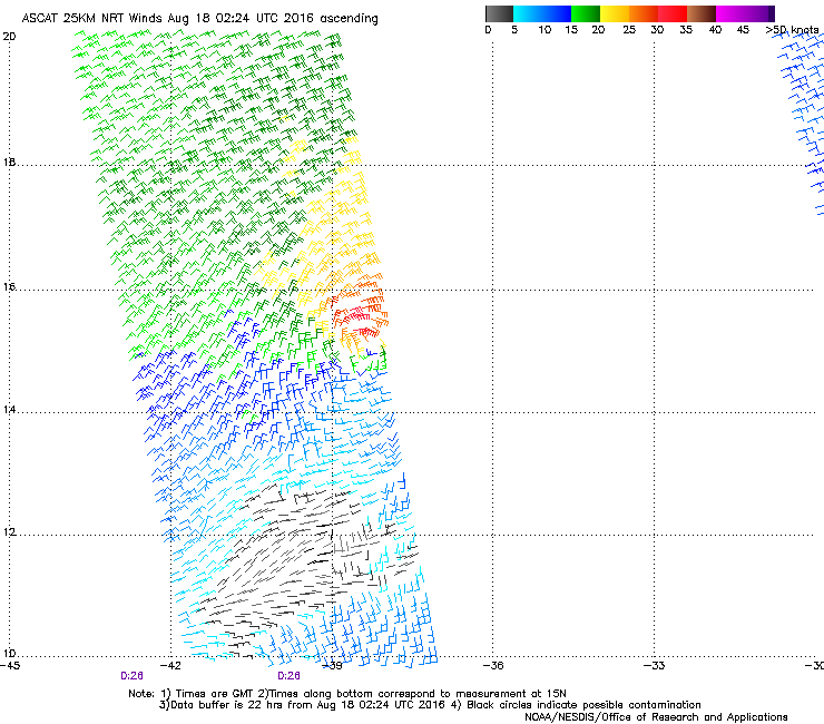
Fiona is barely hanging on to TS status, though the most recent ASCAT pass looks a bit better than the one before, more ~30 kt vectors on the northern side. Their initial 50 kt forecast a bit on the high end in hindsight. Dry air acted fast this evening.
2 likes
--;->#GoNoles--;->.
Re: ATL: FIONA - Tropical Storm - Discussion
gatorcane wrote:Fiona has made a turn more to the WNW as the NHC has stated in the latest advisory. Loop below shows the subtle turn:
http://rammb.cira.colostate.edu/ramsdis ... display=12
Interesting, gator. The prior advisory's initial location was 15.1 N, 37.8 W and its first projection point was 16.0 N, 39.0 W as of 2 AM EDT tonight. However, at 11 PM EDT, it had already reached 39.0 W while it was only up to 15.5 N. So, it essentially moved north a little less than half of how much was projected by the time it reached 39.0 W. Let's see whether or not SW corrections continue down the road.
0 likes
Personal Forecast Disclaimer:
The posts in this forum are NOT official forecasts and should not be used as such. They are just the opinion of the poster and may or may not be backed by sound meteorological data. They are NOT endorsed by any professional institution or storm2k.org. For official information, please refer to the NHC and NWS products.
The posts in this forum are NOT official forecasts and should not be used as such. They are just the opinion of the poster and may or may not be backed by sound meteorological data. They are NOT endorsed by any professional institution or storm2k.org. For official information, please refer to the NHC and NWS products.

Re: ATL: FIONA - Models
cmc cuts about 25 new inlets in the Outer Banks as a powerful hurricane
0 likes
Who is online
Users browsing this forum: No registered users and 8 guests