

ATL: ANA - Post-Tropical
Moderator: S2k Moderators
-
cycloneye

- Admin

- Posts: 139507
- Age: 67
- Joined: Thu Oct 10, 2002 10:54 am
- Location: San Juan, Puerto Rico
Re: ATL: INVEST 90L
18z Best Track:
AL, 90, 2015050618, , BEST, 0, 278N, 787W, 25, 1015, LO, 34, NEQ, 0, 0, 0, 0, 1017, 120, 50, 0, 0, L, 0, , 0, 0, INVEST, M
AL, 90, 2015050618, , BEST, 0, 278N, 787W, 25, 1015, LO, 34, NEQ, 0, 0, 0, 0, 1017, 120, 50, 0, 0, L, 0, , 0, 0, INVEST, M
0 likes
Visit the Caribbean-Central America Weather Thread where you can find at first post web cams,radars
and observations from Caribbean basin members Click Here
and observations from Caribbean basin members Click Here
-
cycloneye
- Admin
- Posts: 139507
- Age: 67
- Joined: Thu Oct 10, 2002 10:54 am
- Location: San Juan, Puerto Rico
Re: ATL: INVEST 90L
SPECIAL TROPICAL WEATHER OUTLOOK
NWS NATIONAL HURRICANE CENTER MIAMI FL
200 PM EDT WED MAY 6 2015
For the North Atlantic...Caribbean Sea and the Gulf of Mexico:
Disorganized showers and thunderstorms extending from the east coast
of Florida across the Bahamas and the adjacent Atlantic waters are
associated with an upper-level trough and a weak surface low located
north of the northwestern Bahamas. Conditions are expected to
become gradually more favorable for development over the next day or
so while this system moves slowly northward and then northwestward.
A subtropical or tropical cyclone could form by tomorrow or Friday,
and interests along the southeast coast of the United States should
monitor the progress of this system through the weekend. Regardless
of development, heavy rain is possible over portions of the coastal
southeastern United States beginning tomorrow. The next Special
Tropical Weather Outlook will be issued on this system by 8 PM EDT
today. For additional information, see products from your local
National Weather Service forecast office and High Seas Forecasts
issued by the National Weather Service.
* Formation chance through 48 hours...medium...60 percent
* Formation chance through 5 days...medium...60 percent
&&
High Seas Forecasts issued by the National Weather Service are
available under AWIPS header NFDHSFAT1, WMO header FZNT01 KWBC, and
on the Web at http://www.opc.ncep.noaa.gov/shtml/NFDHSFAT1.shtml
$$
Forecaster Brennan
0 likes
Visit the Caribbean-Central America Weather Thread where you can find at first post web cams,radars
and observations from Caribbean basin members Click Here
and observations from Caribbean basin members Click Here

Re: ATL: INVEST 90L
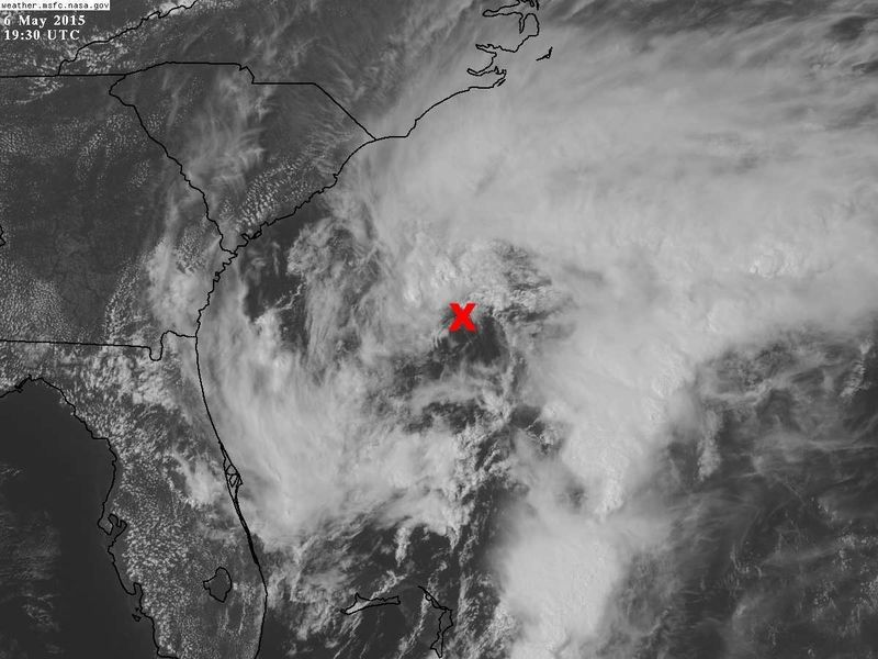
I can definite see the vorticity (possible weak LLC), near 30.8N & 77.3W taking over as the main circulation of the system, buoy 41010 (28.9N, 78.6W) now has winds from 350 deg heading.
0 likes
It will make a difference where 90L stalls and or meanders around over the next 72-96 hrs or so, if it stays 50-100 miles away from the coast it will stay over the fairly warm gulf stream waters, the closer it gets to the coast the much cooler waters, well below 70 degs F, it will encounter which will significantly affect it.
0 likes
-
Evil Jeremy

- S2K Supporter

- Posts: 5459
- Age: 31
- Joined: Mon Apr 10, 2006 2:10 pm
- Location: Los Angeles, CA
Re: ATL: INVEST 90L
000
ABNT20 KNHC 062332
TWOAT
SPECIAL TROPICAL WEATHER OUTLOOK
NWS NATIONAL HURRICANE CENTER MIAMI FL
735 PM EDT WED MAY 6 2015
For the North Atlantic...Caribbean Sea and the Gulf of Mexico:
Disorganized showers and thunderstorms extending northward from the
Bahamas to just offshore of the coast of the Carolinas are
associated with an upper-level trough and a weak surface low located
a couple of hundred miles east of the northeast Florida coast.
Conditions are expected to become gradually more favorable for
development over the next day or so while this system moves slowly
northward and then northwestward. A subtropical or tropical cyclone
could form by tomorrow or Friday, and interests along the southeast
coast of the United States should monitor the progress of this
system. Regardless of development, heavy rain is possible over
portions of the coastal southeastern United States beginning
tomorrow. The next Special Tropical Weather Outlook will be issued
on this system by 2 AM EDT on Thursday. For additional information,
see products from your local National Weather Service forecast
office and High Seas Forecasts issued by the National Weather
Service.
* Formation chance through 48 hours...medium...60 percent
* Formation chance through 5 days...medium...60 percent
0 likes
Frances 04 / Jeanne 04 / Katrina 05 / Wilma 05 / Fay 08 / Debby 12 / Andrea 13 / Colin 16 / Hermine 16 / Matthew 16 / Irma 17
-
TheAustinMan

- Category 5

- Posts: 1012
- Age: 24
- Joined: Mon Jul 08, 2013 4:26 pm
- Location: United States
- Contact:
Re: ATL: INVEST 90L
The posts in this forum are NOT official forecast and should not be used as such. They are just the opinion of the poster and may or may not be backed by sound meteorological data. They are NOT endorsed by any professional institution or storm2k.org. For official information, please refer to the NHC and NWS products.
A lot of us were following the more tropical-based area of convection northwest of Grand Bahama island for much of the day, but I think based on some of the more recent trends, the more baroclinic/temperature gradient based circulation directly east of the Florida/Georgia border is becoming the dominant circulation and may be featuring some closed spin at the surface even with the competing southwestern circulation. Over the evening there's been a surge of convection east of Savannah, Georgia that has persisted over the more northerly circulation, while the spin we were monitoring further south and closer to Bahamas/Florida has lost a lot of the convection due to the influx of convergence towards the northern system. On a broader scale the overall circulation appears to be quite elongated along a north to south axis at around 77W/78W, though this will likely center on a focal point as time goes on.
Last clear visible image before nightfall

850mb vorticity

CIMSS-analyzed lower-level winds

A lot of us were following the more tropical-based area of convection northwest of Grand Bahama island for much of the day, but I think based on some of the more recent trends, the more baroclinic/temperature gradient based circulation directly east of the Florida/Georgia border is becoming the dominant circulation and may be featuring some closed spin at the surface even with the competing southwestern circulation. Over the evening there's been a surge of convection east of Savannah, Georgia that has persisted over the more northerly circulation, while the spin we were monitoring further south and closer to Bahamas/Florida has lost a lot of the convection due to the influx of convergence towards the northern system. On a broader scale the overall circulation appears to be quite elongated along a north to south axis at around 77W/78W, though this will likely center on a focal point as time goes on.
Last clear visible image before nightfall
850mb vorticity
CIMSS-analyzed lower-level winds
0 likes


Treat my opinions with a grain of salt. For official information see your local weather service.
-
jaguarjace

- Category 4

- Posts: 975
- Age: 29
- Joined: Sat Jun 11, 2011 7:38 am
- Location: Khon Kaen, Thailand
Re: ATL: INVEST 90L


0 likes
Owner of the Tropical Archive YouTube channel
Web Developer at Force Thirteen
Twitter/X : @force13_support
Web Developer at Force Thirteen
Twitter/X : @force13_support
-
TropicalAnalystwx13

- Category 5
- Posts: 2109
- Age: 26
- Joined: Tue Jul 19, 2011 8:20 pm
- Location: Wilmington, NC
- Contact:
SPECIAL TROPICAL WEATHER OUTLOOK
NWS NATIONAL HURRICANE CENTER MIAMI FL
150 AM EDT THU MAY 7 2015
For the North Atlantic...Caribbean Sea and the Gulf of Mexico:
A non-tropical low pressure system located about 220 miles
south-southeast of the South Carolina-North Carolina border has been
nearly stationary the past several hours. Showers and thunderstorms
are gradually becoming better organized and environmental conditions
are expected to become more conducive for development over the next
day or so while this system moves slowly northward and then
northwestward. A subtropical or tropical cyclone could form later
today or on Friday, and interests along the southeast coast of the
United States should monitor the progress of this system. An Air
Force Reserve reconnaissance aircraft is scheduled to investigate
the low later this morning. Regardless of development, heavy rain is
possible over portions of the coastal southeastern United States
beginning later today. The next Special Tropical Weather Outlook
will be issued on this system by 8 AM EDT this morning. For
additional information, see products from your local National
Weather Service forecast office and High Seas Forecasts issued by
the National Weather Service.
* Formation chance through 48 hours...high...70 percent
* Formation chance through 5 days...high...70 percent
&&
High Seas Forecasts issued by the National Weather Service are
available under AWIPS header NFDHSFAT1, WMO header FZNT01 KWBC, and
on the Web at http://www.opc.ncep.noaa.gov/shtml/NFDHSFAT1.shtml
$$
Forecaster Stewart/Roberts
0 likes

Re: ATL: INVEST 90L
Not really looking at all impressive in terms of transitioning to a tropical system. Offshore winds might in fact cause this system to be named as a "sub-tropical" system, yet models are not particularly aggressive in deepening this system all that much. Kind of hard for me to think that a classification other than "a gale" should be truly appropriate at the moment, but I suppose we'll see if there's any significant increase in convection closer to the core over the upcoming 24 hours.
0 likes
Personal Forecast Disclaimer:
The posts in this forum are NOT official forecast and should not be used as such. They are just the opinion of the poster and may or may not be backed by sound meteorological data. They are NOT endorsed by any professional institution or storm2k.org. For official information, please refer to the NHC and NWS products.
The posts in this forum are NOT official forecast and should not be used as such. They are just the opinion of the poster and may or may not be backed by sound meteorological data. They are NOT endorsed by any professional institution or storm2k.org. For official information, please refer to the NHC and NWS products.
Lets see what happens as the low pressure center tracks over the warm gulf stream over the next 48 hrs or so if it is able to get convection closer to its center.
Personal Forecast Disclaimer:
The posts in this forum are NOT official forecast and should not be used as such. They are just the opinion of the poster and may or may not be backed by sound meteorological data. They are NOT endorsed by any professional institution or storm2k.org. For official information, please refer to the NHC and NWS products.
0 likes
This is the strongest winds I found from area buoys:
Wind Direction (WDIR): ENE ( 60 deg true )
5-day plot - Wind Speed Wind Speed (WSPD): 31.1 kts
5-day plot - Wind Gust Wind Gust (GST): 36.9 kts
5-day plot - Wave Height Wave Height (WVHT): 8.9 ft
5-day plot - Dominant Wave Period Dominant Wave Period (DPD): 6 sec
5-day plot - Average Period Average Period (APD): 5.6 sec
5-day plot - Mean Wave Direction Mean Wave Direction (MWD): E ( 84 deg true )
5-day plot - Atmospheric Pressure Atmospheric Pressure (PRES): 29.94 in
5-day plot - Pressure Tendency Pressure Tendency (PTDY): -0.04 in ( Falling )
5-day plot - Air Temperature Air Temperature (ATMP): 68.4 °F
5-day plot - Water Temperature Water Temperature (WTMP): 72.0 °F
5-day plot - Dew Point Dew Point (DEWP): 65.3 °F
5-day plot - Wind Speed at 10 Meters Wind Speed at 10 meters (WSPD10M): 33.0 kts
5-day plot - Wind Speed at 10 Meters Wind Speed at 20 meters (WSPD20M): 35.0 kts
http://www.ndbc.noaa.gov/station_page.php?station=41013
0 likes
Re: ATL: INVEST 90L
They always look ugly in the transition phase. The wind increases at Frying Pan Shoals have been pretty steady.
0 likes

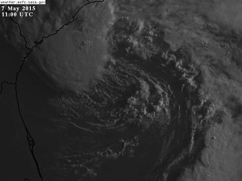
Re: ATL: INVEST 90L
TROPICAL WEATHER DISCUSSION
NWS NATIONAL HURRICANE CENTER MIAMI FL
805 AM EDT THU MAY 07 2015
TROPICAL WEATHER DISCUSSION FOR NORTH AMERICA...CENTRAL
AMERICA...GULF OF MEXICO...CARIBBEAN SEA...NORTHERN SECTIONS OF
SOUTH AMERICA...AND ATLANTIC OCEAN TO THE AFRICAN COAST FROM THE
EQUATOR TO 32N. THE FOLLOWING INFORMATION IS BASED ON SATELLITE
IMAGERY...WEATHER OBSERVATIONS...RADAR...AND METEOROLOGICAL
ANALYSIS.
BASED ON 0600 UTC SURFACE ANALYSIS AND SATELLITE IMAGERY THROUGH
0915 UTC.
...SPECIAL FEATURES...
AS OF 07/0900 UTC...A 1007 MB LOW IS CENTERED NEAR 31N78W WITH A
SURFACE TROUGH AXIS EXTENDING FROM THE LOW CENTER TO 32N77W TO
30N75W TO 28N75W TO 24N78W. THE LOW PRESSURE IS LARGELY
SUPPORTED BY A NEGATIVELY TILTED MIDDLE TO UPPER LEVEL TROUGH
WITH AXIS EXTENDING FROM OVER EASTERN GEORGIA NEAR 33N82W SE TO
A BROAD BASE NEAR 26N77W. MOST OF THE MID-LEVEL VORTICITY IS
TIGHTLY CLUSTERED IN GLOBAL MODEL GUIDANCE IN THE VICINITY OF
31N78W COLLOCATED WITH THE SURFACE LOW. CONVECTION OVERALL
REMAINS LIMITED AS DRY AIR CONTINUES TO WRAP INTO THE SYSTEM
ORIGINATING ON THE WESTERN PERIPHERY AND IMPACTING THE SOUTH AND
SOUTHEAST QUADRANTS. SCATTERED MODERATE CONVECTION IS OCCURRING
FROM 31N-35N BETWEEN 76W-81W...WELL TO THE E-NE FROM 31N-36N
BETWEEN 64W-74W...AND FROM 23N-29N BETWEEN 73W-76W. REGARDLESS
OF SUB-TROPICAL OR TROPICAL CYCLONE DEVELOPMENT DURING THE NEXT
48 HOURS AS THE SYSTEM TRACKS NORTHWARD...HEAVY PRECIPITATION IS
HIGHLY PROBABLE ACROSS PORTIONS OF THE COASTAL SE CONUS THROUGH
SUNDAY.
0 likes
-
cycloneye
- Admin
- Posts: 139507
- Age: 67
- Joined: Thu Oct 10, 2002 10:54 am
- Location: San Juan, Puerto Rico
Re: ATL: INVEST 90L
SPECIAL TROPICAL WEATHER OUTLOOK
NWS NATIONAL HURRICANE CENTER MIAMI FL
745 AM EDT THU MAY 7 2015
For the North Atlantic...Caribbean Sea and the Gulf of Mexico:
1. A non-tropical low pressure system located about 230 miles south-
southeast of the South Carolina-North Carolina border has moved
little during the past several hours. Since yesterday, the low has
become better defined with increasing organization of the associated
thunderstorm activity. Environmental conditions are gradually
becoming more conducive for development, and an increase in the
organization of the thunderstorms could result in the formation of a
subtropical cyclone later today or on Friday. An Air Force Reserve
reconnaissance aircraft is scheduled to investigate the low this
morning. The low is expected to drift generally northward over the
next couple of days, and interests along the southeastern coast of
the United States should continue to monitor the progress of this
system. Regardless of development, heavy rain is expected over
portions of the coastal southeastern United States for the next
several days. For additional information, see products from your
local National Weather Service forecast office and High Seas
Forecasts issued by the National Weather Service. The next Special
Tropical Weather Outlook on this system will be issued by 2 PM EDT.
* Formation chance through 48 hours...high...70 percent
* Formation chance through 5 days...high...70 percent
High Seas Forecasts issued by the National Weather Service are
available under AWIPS header NFDHSFAT1, WMO header FZNT01 KWBC, and
on the Web at http://www.opc.ncep.noaa.gov/shtml/NFDHSFAT1.shtml
Forecaster Blake
0 likes
Visit the Caribbean-Central America Weather Thread where you can find at first post web cams,radars
and observations from Caribbean basin members Click Here
and observations from Caribbean basin members Click Here
-
tolakram
- Admin
- Posts: 19175
- Age: 60
- Joined: Sun Aug 27, 2006 8:23 pm
- Location: Florence, KY (name is Mark)
Live visible loop: http://wwwghcc.msfc.nasa.gov/cgi-bin/ge ... color=gray
0 likes
M a r k
- - - - -
Join us in chat: Storm2K Chatroom Invite. Android and IOS apps also available.
The posts in this forum are NOT official forecasts and should not be used as such. Posts are NOT endorsed by any professional institution or STORM2K.org. For official information and forecasts, please refer to NHC and NWS products.
-
SouthDadeFish

- Professional-Met

- Posts: 2835
- Joined: Thu Sep 23, 2010 2:54 pm
- Location: Miami, FL
- Contact:
Re: ATL: INVEST 90L
Looks like this system won't be moving much over the next 2 days. The transition to a TC (if it ever happens) will probably be quite slow as well, due to the marginal SSTs.
0 likes
-
cycloneye
- Admin
- Posts: 139507
- Age: 67
- Joined: Thu Oct 10, 2002 10:54 am
- Location: San Juan, Puerto Rico
Re: ATL: INVEST 90L
12z Best Track:
AL, 90, 2015050712, , BEST, 0, 307N, 774W, 30, 1010, LO, 34, NEQ, 0, 0, 0, 0, 1016, 210, 100, 40, 0, L, 0, , 0, 0, INVEST, M
AL, 90, 2015050712, , BEST, 0, 307N, 774W, 30, 1010, LO, 34, NEQ, 0, 0, 0, 0, 1016, 210, 100, 40, 0, L, 0, , 0, 0, INVEST, M
0 likes
Visit the Caribbean-Central America Weather Thread where you can find at first post web cams,radars
and observations from Caribbean basin members Click Here
and observations from Caribbean basin members Click Here

-
jaguarjace
- Category 4
- Posts: 975
- Age: 29
- Joined: Sat Jun 11, 2011 7:38 am
- Location: Khon Kaen, Thailand
Re: ATL: INVEST 90L


0 likes
Owner of the Tropical Archive YouTube channel
Web Developer at Force Thirteen
Twitter/X : @force13_support
Web Developer at Force Thirteen
Twitter/X : @force13_support
Who is online
Users browsing this forum: No registered users and 4 guests