TROPICAL CYCLONE GUIDANCE MESSAGE
NWS NATIONAL HURRICANE CENTER MIAMI FL
0118 UTC FRI AUG 30 2013
DISCLAIMER...NUMERICAL MODELS ARE SUBJECT TO LARGE ERRORS.
PLEASE REFER TO NHC OFFICIAL FORECASTS FOR TROPICAL CYCLONE
AND SUBTROPICAL CYCLONE INFORMATION.
ATLANTIC OBJECTIVE AIDS FOR
DISTURBANCE INVEST (AL962013) 20130830 0000 UTC
...00 HRS... ...12 HRS... ...24 HRS... ...36 HRS...
130830 0000 130830 1200 130831 0000 130831 1200
LAT LON LAT LON LAT LON LAT LON
BAMS 14.5N 15.5W 14.9N 16.9W 15.7N 18.7W 16.7N 21.2W
BAMD 14.5N 15.5W 14.9N 18.2W 15.2N 20.8W 15.6N 23.6W
BAMM 14.5N 15.5W 14.9N 17.9W 15.3N 20.3W 15.8N 23.1W
LBAR 14.5N 15.5W 15.2N 18.2W 16.0N 21.3W 16.9N 24.6W
SHIP 20KTS 26KTS 31KTS 39KTS
DSHP 20KTS 28KTS 33KTS 42KTS
...48 HRS... ...72 HRS... ...96 HRS... ..120 HRS...
130901 0000 130902 0000 130903 0000 130904 0000
LAT LON LAT LON LAT LON LAT LON
BAMS 17.9N 24.0W 20.8N 30.1W 24.5N 36.1W 28.0N 41.5W
BAMD 15.9N 26.4W 16.6N 31.6W 19.1N 35.8W 24.5N 39.5W
BAMM 16.2N 26.0W 17.2N 31.4W 19.8N 36.4W 24.2N 41.4W
LBAR 18.3N 28.1W 22.0N 33.0W 28.7N 36.0W 31.9N 34.1W
SHIP 46KTS 60KTS 62KTS 58KTS
DSHP 48KTS 62KTS 64KTS 60KTS
...INITIAL CONDITIONS...
LATCUR = 14.5N LONCUR = 15.5W DIRCUR = 280DEG SPDCUR = 13KT
LATM12 = 14.0N LONM12 = 12.9W DIRM12 = 284DEG SPDM12 = 13KT
LATM24 = 13.2N LONM24 = 9.0W
WNDCUR = 20KT RMAXWD = 120NM WNDM12 = 20KT
CENPRS = 1009MB OUTPRS = 1011MB OUTRAD = 150NM SDEPTH = S
RD34NE = 0NM RD34SE = 0NM RD34SW = 0NM RD34NW = 0NM
ATL: INVEST 96L - Models
Moderator: S2k Moderators
-
cycloneye

- Admin

- Posts: 139173
- Age: 67
- Joined: Thu Oct 10, 2002 10:54 am
- Location: San Juan, Puerto Rico
ATL: INVEST 96L - Models
0 likes
Visit the Caribbean-Central America Weather Thread where you can find at first post web cams,radars
and observations from Caribbean basin members Click Here
and observations from Caribbean basin members Click Here


-
tolakram
- Admin
- Posts: 19165
- Age: 60
- Joined: Sun Aug 27, 2006 8:23 pm
- Location: Florence, KY (name is Mark)
Re: ATL: INVEST 96L - Models
GFS 18Z run, vorticity. Notice how it gets hung up around 165 hours and moves west?
http://www.tropicaltidbits.com/analysis/models/gfsfull/2013082918/gfsfull_pres_wind_atltropics.html
At the end of high resolution mode it shoots out NE, which is a likely solution, but strengthening while moving west is interesting.
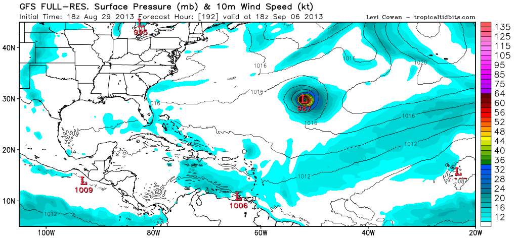
http://www.tropicaltidbits.com/analysis/models/gfsfull/2013082918/gfsfull_pres_wind_atltropics.html
At the end of high resolution mode it shoots out NE, which is a likely solution, but strengthening while moving west is interesting.
0 likes
M a r k
- - - - -
Join us in chat: Storm2K Chatroom Invite. Android and IOS apps also available.
The posts in this forum are NOT official forecasts and should not be used as such. Posts are NOT endorsed by any professional institution or STORM2K.org. For official information and forecasts, please refer to NHC and NWS products.


Re: ATL: INVEST 96L - Models
Okay folks, I'm not suggesting that 96L is suddenly gonna fool everyone and make it all the way west to Houston....., but look where the models have initialized the system, and then take a close look at the "Shortwave IR satellite (http://www.ssd.noaa.gov/PS/TROP/floater ... short.html); looks to me as if it has come off the coast a bit to the south at 13.8N and 17.8W and presently moving at 270 (or maybe even a hair south of due west?)
0 likes
Personal Forecast Disclaimer:
The posts in this forum are NOT official forecast and should not be used as such. They are just the opinion of the poster and may or may not be backed by sound meteorological data. They are NOT endorsed by any professional institution or storm2k.org. For official information, please refer to the NHC and NWS products.
The posts in this forum are NOT official forecast and should not be used as such. They are just the opinion of the poster and may or may not be backed by sound meteorological data. They are NOT endorsed by any professional institution or storm2k.org. For official information, please refer to the NHC and NWS products.

Re: ATL: INVEST 96L - Models
tolakram wrote:GFS 18Z run, vorticity. Notice how it gets hung up around 165 hours and moves west?
[ url]http://www.tropicaltidbits.com/analysis/models/gfsfull/2013082918/gfsfull_pres_wind_atltropics.html[/url]
At the end of high resolution mode it shoots out NE, which is a likely solution, but strengthening while moving west is interesting.
[ img]http://img96.imageshack.us/img96/1404/i2oi.png[/img]
Let it spin around the rack up the ACE.
0 likes
-
CrazyC83
- Professional-Met

- Posts: 33393
- Joined: Tue Mar 07, 2006 11:57 pm
- Location: Deep South, for the first time!
Re: ATL: INVEST 96L - Models
tolakram wrote:GFS 18Z run, vorticity. Notice how it gets hung up around 165 hours and moves west?
http://www.tropicaltidbits.com/analysis/models/gfsfull/2013082918/gfsfull_pres_wind_atltropics.html
At the end of high resolution mode it shoots out NE, which is a likely solution, but strengthening while moving west is interesting.
North of 25N, shear is lower and instability better.
0 likes
-
supercane4867
- Category 5

- Posts: 4966
- Joined: Wed Nov 14, 2012 10:43 am
-
ninel conde
- Category 5
- Posts: 1245
- Joined: Mon Aug 04, 2008 2:18 pm
Re: ATL: INVEST 96L - Models
supercane4867 wrote:12z GFS totally drops it
not a surprise. some very dry air is beginning to engulf it.
0 likes
The posts in this forum are NOT official forecast and should not be used as such. They are just the opinion of the poster and may or may not be backed by sound meteorological data. They are NOT endorsed by any professional institution or storm2k.org. For official information, please refer to the NHC and NWS products.
-
cycloneye
- Admin
- Posts: 139173
- Age: 67
- Joined: Thu Oct 10, 2002 10:54 am
- Location: San Juan, Puerto Rico
Re: ATL: INVEST 96L - Models
New plots at 18z.
TROPICAL CYCLONE GUIDANCE MESSAGE
NWS NATIONAL HURRICANE CENTER MIAMI FL
2017 UTC FRI AUG 30 2013
DISCLAIMER...NUMERICAL MODELS ARE SUBJECT TO LARGE ERRORS.
PLEASE REFER TO NHC OFFICIAL FORECASTS FOR TROPICAL CYCLONE
AND SUBTROPICAL CYCLONE INFORMATION.
ATLANTIC OBJECTIVE AIDS FOR
DISTURBANCE INVEST (AL962013) 20130830 1800 UTC
...00 HRS... ...12 HRS... ...24 HRS... ...36 HRS...
130830 1800 130831 0600 130831 1800 130901 0600
LAT LON LAT LON LAT LON LAT LON
BAMS 13.6N 16.0W 14.0N 17.2W 14.8N 19.4W 15.9N 22.3W
BAMD 13.6N 16.0W 14.0N 18.3W 14.4N 21.0W 15.1N 23.9W
BAMM 13.6N 16.0W 14.1N 17.7W 15.1N 20.3W 16.2N 23.5W
LBAR 13.6N 16.0W 13.9N 18.0W 14.5N 20.8W 15.1N 23.8W
SHIP 25KTS 30KTS 35KTS 39KTS
DSHP 25KTS 31KTS 36KTS 40KTS
...48 HRS... ...72 HRS... ...96 HRS... ..120 HRS...
130901 1800 130902 1800 130903 1800 130904 1800
LAT LON LAT LON LAT LON LAT LON
BAMS 17.1N 25.9W 19.9N 33.6W 23.3N 40.8W 26.4N 46.5W
BAMD 16.0N 27.1W 18.4N 33.2W 23.6N 37.9W 29.4N 39.3W
BAMM 17.7N 27.3W 21.1N 34.3W 26.0N 40.0W 29.9N 43.2W
LBAR 15.9N 27.2W 17.9N 34.0W 22.1N 39.4W 27.3N 46.3W
SHIP 42KTS 45KTS 42KTS 44KTS
DSHP 44KTS 46KTS 43KTS 45KTS
...INITIAL CONDITIONS...
LATCUR = 13.6N LONCUR = 16.0W DIRCUR = 275DEG SPDCUR = 6KT
LATM12 = 13.5N LONM12 = 14.8W DIRM12 = 270DEG SPDM12 = 6KT
LATM24 = 13.5N LONM24 = 12.9W
WNDCUR = 25KT RMAXWD = 100NM WNDM12 = 20KT
CENPRS = 1007MB OUTPRS = 1009MB OUTRAD = 150NM SDEPTH = S
RD34NE = 0NM RD34SE = 0NM RD34SW = 0NM RD34NW = 0NM
0 likes
Visit the Caribbean-Central America Weather Thread where you can find at first post web cams,radars
and observations from Caribbean basin members Click Here
and observations from Caribbean basin members Click Here
-
Bocadude85

- Category 5
- Posts: 2941
- Age: 37
- Joined: Mon Apr 18, 2005 2:20 pm
- Location: Honolulu,Hi
Re: ATL: INVEST 96L - Models
supercane4867 wrote:12z GFS totally drops it
The 12z GFS did not drop development.
0 likes
-
ninel conde
- Category 5
- Posts: 1245
- Joined: Mon Aug 04, 2008 2:18 pm
Re: ATL: INVEST 96L - Models
Bocadude85 wrote:supercane4867 wrote:12z GFS totally drops it
The 12z GFS did not drop development.
http://moe.met.fsu.edu/cgi-bin/gfstc2.c ... hour=120hr
0 likes
The posts in this forum are NOT official forecast and should not be used as such. They are just the opinion of the poster and may or may not be backed by sound meteorological data. They are NOT endorsed by any professional institution or storm2k.org. For official information, please refer to the NHC and NWS products.
-
CYCLONE MIKE
- Category 5
- Posts: 2183
- Joined: Tue Aug 31, 2004 6:04 pm
- Location: Gonzales, LA
Re: ATL: INVEST 96L - Models
Bocadude85 wrote:supercane4867 wrote:12z GFS totally drops it
The 12z GFS did not drop development.
Well then perhaps you can show us where the gfs still has it because I'm either looking at the totally wrong location or can't read maps because I didn't see it on the 12z or 18z runs .
0 likes
-
ninel conde
- Category 5
- Posts: 1245
- Joined: Mon Aug 04, 2008 2:18 pm
i dont even think the cmc develops it.
0 likes
The posts in this forum are NOT official forecast and should not be used as such. They are just the opinion of the poster and may or may not be backed by sound meteorological data. They are NOT endorsed by any professional institution or storm2k.org. For official information, please refer to the NHC and NWS products.
-
cycloneye
- Admin
- Posts: 139173
- Age: 67
- Joined: Thu Oct 10, 2002 10:54 am
- Location: San Juan, Puerto Rico
Re: ATL: INVEST 96L - Models
TROPICAL CYCLONE GUIDANCE MESSAGE
NWS NATIONAL HURRICANE CENTER MIAMI FL
0048 UTC SAT AUG 31 2013
DISCLAIMER...NUMERICAL MODELS ARE SUBJECT TO LARGE ERRORS.
PLEASE REFER TO NHC OFFICIAL FORECASTS FOR TROPICAL CYCLONE
AND SUBTROPICAL CYCLONE INFORMATION.
ATLANTIC OBJECTIVE AIDS FOR
DISTURBANCE INVEST (AL962013) 20130831 0000 UTC
...00 HRS... ...12 HRS... ...24 HRS... ...36 HRS...
130831 0000 130831 1200 130901 0000 130901 1200
LAT LON LAT LON LAT LON LAT LON
BAMS 14.1N 16.7W 14.6N 18.2W 15.7N 20.8W 17.1N 24.4W
BAMD 14.1N 16.7W 14.6N 19.4W 15.2N 22.4W 15.8N 25.6W
BAMM 14.1N 16.7W 14.8N 18.8W 15.8N 21.7W 17.0N 25.4W
LBAR 14.1N 16.7W 14.5N 18.8W 15.2N 21.7W 15.9N 24.9W
SHIP 30KTS 36KTS 41KTS 45KTS
DSHP 30KTS 39KTS 44KTS 48KTS
...48 HRS... ...72 HRS... ...96 HRS... ..120 HRS...
130902 0000 130903 0000 130904 0000 130905 0000
LAT LON LAT LON LAT LON LAT LON
BAMS 18.8N 28.5W 23.2N 36.1W 28.2N 41.6W 31.9N 42.5W
BAMD 16.6N 28.9W 19.1N 34.8W 24.3N 39.7W 29.2N 41.9W
BAMM 18.5N 29.2W 22.4N 35.8W 27.5N 40.8W 31.0N 42.1W
LBAR 16.6N 28.2W 19.0N 34.7W 23.4N 40.2W 26.3N 47.0W
SHIP 48KTS 48KTS 43KTS 43KTS
DSHP 51KTS 51KTS 46KTS 46KTS
...INITIAL CONDITIONS...
LATCUR = 14.1N LONCUR = 16.7W DIRCUR = 280DEG SPDCUR = 7KT
LATM12 = 13.5N LONM12 = 15.5W DIRM12 = 275DEG SPDM12 = 6KT
LATM24 = 13.5N LONM24 = 14.2W
WNDCUR = 30KT RMAXWD = 90NM WNDM12 = 20KT
CENPRS = 1008MB OUTPRS = 1010MB OUTRAD = 120NM SDEPTH = S
RD34NE = 0NM RD34SE = 0NM RD34SW = 0NM RD34NW = 0NM
0 likes
Visit the Caribbean-Central America Weather Thread where you can find at first post web cams,radars
and observations from Caribbean basin members Click Here
and observations from Caribbean basin members Click Here
-
gatorcane

- S2K Supporter

- Posts: 23499
- Age: 46
- Joined: Sun Mar 13, 2005 3:54 pm
- Location: Boca Raton, FL
Re:
Alyono wrote:18Z GFS abandoned development
Here we go again with the GFS...
Several days of promising runs for some development in the short to medium term.
Now no development and completely POOFs the system by 120 hours...

0 likes
-
Bocadude85
- Category 5
- Posts: 2941
- Age: 37
- Joined: Mon Apr 18, 2005 2:20 pm
- Location: Honolulu,Hi
Re: ATL: INVEST 96L - Models
CYCLONE MIKE wrote:Bocadude85 wrote:supercane4867 wrote:12z GFS totally drops it
The 12z GFS did not drop development.
Well then perhaps you can show us where the gfs still has it because I'm either looking at the totally wrong location or can't read maps because I didn't see it on the 12z or 18z runs .
[url]
http://mag.ncep.noaa.gov/data/gfs/12/gf ... ip_p24.gif [/url]
0 likes
Re: Re:
gatorcane wrote:Alyono wrote:18Z GFS abandoned development
Here we go again with the GFS...
Several days of promising runs for some development in the short to medium term.
Now no development and completely POOFs the system by 120 hours...
As par the course for this season.
0 likes
Who is online
Users browsing this forum: No registered users and 71 guests