WPAC: PEWA - Tropical Storm
Moderator: S2k Moderators

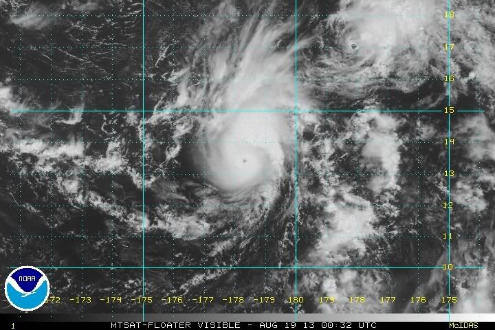
Still an STS
WTPQ21 RJTD 190000
RSMC TROPICAL CYCLONE ADVISORY
NAME STS 1313 PEWA (1313)
ANALYSIS
PSTN 190000UTC 13.3N 178.4E GOOD
MOVE NW 08KT
PRES 990HPA
MXWD 055KT
GUST 080KT
50KT 20NM
30KT 90NM
FORECAST
24HF 200000UTC 15.8N 175.6E 75NM 70%
MOVE NW 12KT
PRES 980HPA
MXWD 065KT
GUST 095KT
48HF 210000UTC 19.4N 171.8E 140NM 70%
MOVE NW 12KT
PRES 975HPA
MXWD 070KT
GUST 100KT
72HF 220000UTC 21.9N 167.9E 210NM 70%
MOVE NW 12KT
PRES 975HPA
MXWD 070KT
GUST 100KT =
Last edited by vrif on Sun Aug 18, 2013 8:07 pm, edited 1 time in total.
0 likes
Re: WPAC: PEWA - Severe Tropical Storm
Looks like CMA is the first to upgrade it to a TY. Time to wait for JMA.
WTPQ20 BABJ 190000
SUBJECTIVE FORECAST
TY PEWA 1313 (1313) INITIAL TIME 190000 UTC
00HR 13.3N 178.4E 980HPA 33M/S
30KTS 150KM
50KTS 50KM
P12HR NW 20KM/H
P+24HR 16.6N 174.6E 980HPA 33M/S
P+48HR 19.2N 170.3E 975HPA 35M/S
P+72HR 22.6N 167.0E 970HPA 38M/S
P+96HR 25.0N 164.2E 970HPA 38M/S
P+120HR 26.5N 161.9E 975HPA 35M/S=
0 likes
-
hurricanes1234
- Category 5

- Posts: 2903
- Joined: Sat Jul 28, 2012 6:19 pm
- Location: Trinidad and Tobago
Re: WPAC: PEWA - Severe Tropical Storm
This may actually have a shot at becoming a Category 3 typhoon or higher.
Personal Forecast Disclaimer: The posts in this forum are NOT official forecast and should not be used as such. They are just the opinion of the poster and may or may not be backed by sound meteorological data. They are NOT endorsed by any professional institution or storm2k.org. For official information, please refer to the NHC and NWS products.
Personal Forecast Disclaimer: The posts in this forum are NOT official forecast and should not be used as such. They are just the opinion of the poster and may or may not be backed by sound meteorological data. They are NOT endorsed by any professional institution or storm2k.org. For official information, please refer to the NHC and NWS products.
0 likes
PLEASE NOTE: With the exception of information from weather agencies that I may copy and paste here, my posts will NEVER be official, since I am NOT a meteorologist. They are solely my amateur opinion, and may or may not be accurate. Therefore, please DO NOT use them as official details, particularly when making important decisions. Thank you.

Re: WPAC: PEWA - Severe Tropical Storm
JMA issued a Typhoon Warning for a STS PEWA. Considering a pinhole eye is visible on satellite, perhaps an upgrade in the near future?
WTJP22 RJTD 190000
WARNING 190000.
WARNING VALID 200000.
WARNING IS UPDATED EVERY 6 HOURS.
TYPHOON WARNING.
SEVERE TROPICAL STORM 1313 PEWA (1313) 990 HPA
AT 13.3N 178.4E MIDWAYS MOVING NORTHWEST 08 KNOTS.
POSITION GOOD.
MAX WINDS 55 KNOTS NEAR CENTER.
RADIUS OF OVER 50 KNOT WINDS 20 MILES.
RADIUS OF OVER 30 KNOT WINDS 90 MILES.
FORECAST POSITION FOR 200000UTC AT 15.8N 175.6E WITH 75 MILES RADIUS
OF 70 PERCENT PROBABILITY CIRCLE.
980 HPA, MAX WINDS 65 KNOTS NEAR CENTER.
EXTENDED OUTLOOK.
FORECAST POSITION FOR 210000UTC AT 19.4N 171.8E WITH 140 MILES RADIUS
OF 70 PERCENT PROBABILITY CIRCLE.
975 HPA, MAX WINDS 70 KNOTS NEAR CENTER.
FORECAST POSITION FOR 220000UTC AT 21.9N 167.9E WITH 210 MILES RADIUS
OF 70 PERCENT PROBABILITY CIRCLE.
975 HPA, MAX WINDS 70 KNOTS NEAR CENTER.
JAPAN METEOROLOGICAL AGENCY.=
WTPQ31 RJTD 190000
RSMC TROPICAL CYCLONE PROGNOSTIC REASONING
REASONING NO. 2 FOR STS 1313 PEWA (1313)
1.GENERAL COMMENTS
POSITION FORECAST IS MAINLY BASED ON NWP AND PERSISTENCY.
2.SYNOPTIC SITUATION
NOTHING PARTICULAR TO EXPLAIN.
3.MOTION FORECAST
POSITION ACCURACY AT 190000 UTC IS FAIR.
STS WILL MOVE AT THE SAME SPEED FOR THE NEXT 48 HOURS THEN DECELERATE.
STS WILL MOVE NORTHWEST FOR THE NEXT 72 HOURS.
4.INTENSITY FORECAST
STS WILL BE GRADED UP TO TY WITHIN 24 HOURS.
STS WILL DEVELOP BECAUSE CYCLONE WILL STAY IN HIGH SST AREA.
FI-NUMBER WILL BE 4.0 AFTER 24 HOURS.=
0 likes
WTPQ21 RJTD 190300
RSMC TROPICAL CYCLONE ADVISORY
NAME STS 1313 PEWA (1313)
ANALYSIS
PSTN 190300UTC 13.6N 178.1E GOOD
MOVE NW 08KT
PRES 990HPA
MXWD 055KT
GUST 080KT
50KT 20NM
30KT 90NM
FORECAST
24HF 200300UTC 16.2N 175.3E 75NM 70%
MOVE NW 15KT
PRES 980HPA
MXWD 065KT
GUST 095KT
45HF 210000UTC 19.4N 171.8E 140NM 70%
MOVE NW 12KT
PRES 975HPA
MXWD 070KT
GUST 100KT
69HF 220000UTC 21.9N 167.9E 210NM 70%
MOVE NW 12KT
PRES 975HPA
MXWD 070KT
GUST 100KT =
0 likes
Re: WPAC: PEWA - Severe Tropical Storm
An earlier OSCAT pass when PEWA was starting to reveal its eye

0 likes
Still a STS
WTPQ21 RJTD 190600
RSMC TROPICAL CYCLONE ADVISORY
NAME STS 1313 PEWA (1313)
ANALYSIS
PSTN 190600UTC 14.0N 178.0E GOOD
MOVE NW 08KT
PRES 990HPA
MXWD 055KT
GUST 080KT
50KT 20NM
30KT 90NM
FORECAST
24HF 200600UTC 16.7N 175.1E 75NM 70%
MOVE NW 16KT
PRES 980HPA
MXWD 065KT
GUST 095KT
48HF 210600UTC 20.1N 171.2E 140NM 70%
MOVE NW 13KT
PRES 975HPA
MXWD 070KT
GUST 100KT
72HF 220600UTC 23.0N 168.0E 160NM 70%
MOVE NW 10KT
PRES 975HPA
MXWD 070KT
GUST 100KT =
0 likes

-
beoumont

- Category 1

- Posts: 473
- Joined: Sun Jul 10, 2011 4:13 pm
- Location: East Central Florida
- Contact:
Re: WPAC: PEWA - Severe Tropical Storm
Unless the upper low to the NW kills it poste haste:

0 likes
List of 79 tropical cyclones intercepted by Richard Horodner:
http://www.canebeard.com/page/page/572246.htm
http://www.canebeard.com/page/page/572246.htm
-
Iceman56
WTPQ21 RJTD 191800
RSMC TROPICAL CYCLONE ADVISORY
NAME STS 1313 PEWA (1313)
ANALYSIS
PSTN 191800UTC 14.8N 176.5E GOOD
MOVE WNW 08KT
PRES 990HPA
MXWD 055KT
GUST 080KT
50KT 20NM
30KT 90NM
FORECAST
24HF 201800UTC 17.8N 174.1E 70NM 70%
MOVE NW 09KT
PRES 980HPA
MXWD 065KT
GUST 095KT
48HF 211800UTC 21.4N 170.5E 140NM 70%
MOVE NW 11KT
PRES 975HPA
MXWD 070KT
GUST 100KT
72HF 221800UTC 24.4N 167.2E 210NM 70%
MOVE NW 11KT
PRES 975HPA
MXWD 070KT
GUST 100KT =
0 likes
-
wxman57

- Moderator-Pro Met

- Posts: 22482
- Age: 66
- Joined: Sat Jun 21, 2003 8:06 pm
- Location: Houston, TX (southwest)
Re: WPAC: PEWA - Severe Tropical Storm
Latest OSCAT pass from around 12Z indicates Pewa weakened to about a 40kt TS. Microwave imagery indicates a severely-sheared TS with the center displaced SW of the convection.

0 likes
-
Kingarabian

- S2K Supporter

- Posts: 15439
- Joined: Sat Aug 08, 2009 3:06 am
- Location: Honolulu, Hawaii
Who is online
Users browsing this forum: No registered users and 73 guests