ATL: INVEST 94L - Discussion

Moderator: S2k Moderators

Message
Author
Ntxw
Storm2k Moderator
Storm2k Moderator
Posts: 21517
Joined: Wed Oct 21, 2009 6:34 pm
Location: DFW, Texas

Re: ATL: INVEST 94L - Discussion

#61 Postby Ntxw » Fri Jul 05, 2013 6:38 pm

South Texas Storms wrote:Unfortunately the models aren't showing much rain making it at least 50 miles inland for some reason. I don't know why. Hopefully they bust.


Unlike the eastern gulf coast, we've been under northerly flow. This isn't going to help 94L develop much rainfall inland away from the coast. They (EGOM) are on the backside of the Bermuda high and get constant moist southerly flow. I want to see 94L grow in size and be less dependent on the synoptic pattern and have a mind of it's own and flip the flow in Texas to southeasterly but I think it would need a landfall somewhere in N MX.S TX and head due north/NW like a Hermine to bring meaninful rain away from the coastal bend.
0 likes   
The above post and any post by Ntxw is NOT an official forecast and should not be used as such. It is just the opinion of the poster and may or may not be backed by sound meteorological data. It is NOT endorsed by any professional institution including Storm2k. For official information, please refer to NWS products.

  Help support Storm2K!
Help Support Storm2K

ozonepete
Professional-Met
Professional-Met
Posts: 4743
Joined: Mon Sep 07, 2009 3:23 pm
Location: From Ozone Park, NYC / Now in Brooklyn, NY

Re: ATL: INVEST 94L - Discussion

#62 Postby ozonepete » Fri Jul 05, 2013 7:15 pm

Ntxw wrote:
South Texas Storms wrote:Unfortunately the models aren't showing much rain making it at least 50 miles inland for some reason. I don't know why. Hopefully they bust.


Unlike the eastern gulf coast, we've been under northerly flow. This isn't going to help 94L develop much rainfall inland away from the coast. They (EGOM) are on the backside of the Bermuda high and get constant moist southerly flow. I want to see 94L grow in size and be less dependent on the synoptic pattern and have a mind of it's own and flip the flow in Texas to southeasterly but I think it would need a landfall somewhere in N MX.S TX and head due north/NW like a Hermine to bring meaninful rain away from the coastal bend.


There's a decent chance.The biggest negative for 94L developing is all of that shear but it is forecast to relax somewhat and there is already less shear to the north, so any northward movement into lower shear would help the broader low tighten up into a more concentrated surface low - that all would help Texas get some rain. Let's hope that happens.
0 likes   

User avatar
LaBreeze
Category 5
Category 5
Posts: 1497
Joined: Thu Sep 04, 2003 1:57 pm
Location: SW Louisiana

Re: ATL: INVEST 94L - Discussion

#63 Postby LaBreeze » Fri Jul 05, 2013 7:23 pm

PauleinHouston wrote:
LaBreeze wrote:Is this "system" more likely to go inland south of Corpus Christi, between Corpus and Galveston, or between Galveston and Sabine Pass?


There is no "likely" to be honest. It could quite easily go any direction, but models have been hinting at a Northerly component and then a N/NW component Saturday/Sat evening. If it skirts the coast and remains over the 30C Gulf temps and shear lessens as hinted, there is a chance of development into a weak depression at best. Shear reduction is the key here. If if goes toward Central Texas coast, I'll have to give some kudo's to the new Navgem (Nogaps replacement) as it's hinted/shown this system for a few consistent days now.


Sorry about the "likely" part - I should have added "at this moment what are the models suggesting", but thanks for your input.
0 likes   

ozonepete
Professional-Met
Professional-Met
Posts: 4743
Joined: Mon Sep 07, 2009 3:23 pm
Location: From Ozone Park, NYC / Now in Brooklyn, NY

Re: ATL: INVEST 94L - Models

#64 Postby ozonepete » Fri Jul 05, 2013 8:03 pm

djmikey wrote::?: Wait. I'm confused. Why are the models wanting to bring this into the Brownsville area? I thought 94L was headed to the upper TX coast. 3 solid days of the talk of TX/LA border.....What just happened?


You are correct that the models initially wanted to bring it further north. The change is because the deep Atlantic ridge is expected to build further westward and could suppress the low from going as far north and force it more westward. But southerngale (and the post she linked to) is right about that you still get rain because it should be a pretty broad system. But none of the models take the center over Houston anymore - they started moving the center of this low more westward last night. And it's still just too early to tell. The 8PM model runs, which will be visible by 11 or 11:30PM EDT, should have a better handle on the whole story. I surely hope the ridge is weaker and most of Texas gets the rain it desperately needs.
0 likes   

PauleinHouston
Tropical Storm
Tropical Storm
Posts: 102
Joined: Mon Aug 13, 2007 10:23 am
Location: League City, TX
Contact:

Re: ATL: INVEST 94L - Discussion

#65 Postby PauleinHouston » Fri Jul 05, 2013 8:15 pm

LaBreeze wrote:
PauleinHouston wrote:
LaBreeze wrote:Is this "system" more likely to go inland south of Corpus Christi, between Corpus and Galveston, or between Galveston and Sabine Pass?


There is no "likely" to be honest. It could quite easily go any direction, but models have been hinting at a Northerly component and then a N/NW component Saturday/Sat evening. If it skirts the coast and remains over the 30C Gulf temps and shear lessens as hinted, there is a chance of development into a weak depression at best. Shear reduction is the key here. If if goes toward Central Texas coast, I'll have to give some kudo's to the new Navgem (Nogaps replacement) as it's hinted/shown this system for a few consistent days now.


Sorry about the "likely" part - I should have added "at this moment what are the models suggesting", but thanks for your input.


No apologies at all! My input is just an amateur guess based on what I see model-wise, etc. If I was betting, I'd put it moving inland over South Texas and maybe skirting the coast a bit before turning NWesterly. The Bermuda high is reaching out Westward and may well push it inland...still giving a good chance of much needed rains.
0 likes   
The posts in this forum are NOT official forecasts and should not be used as such. They are just the opinion of this amateur poster and may or may not be backed by sound meteorological data. They are NOT endorsed by any professional institution or storm2k.org. For official information, please refer to NWS products.

djmikey
Tropical Storm
Tropical Storm
Posts: 151
Joined: Tue Jul 20, 2010 6:04 pm
Location: Beaumont, TX

Re: ATL: INVEST 94L - Discussion

#66 Postby djmikey » Fri Jul 05, 2013 11:27 pm

Wow...with all these possibilities for the gulf disturbance, I think I'm hearing crickets chirp. :sleeping:
0 likes   

User avatar
Cyclenall
Category 5
Category 5
Posts: 6627
Joined: Thu Jun 08, 2006 10:01 pm
Location: Ontario, Canada

Re: ATL: INVEST 94L - Discussion

#67 Postby Cyclenall » Fri Jul 05, 2013 11:29 pm

djmikey wrote:Wow...with all these possibilities for the gulf disturbance, I think I'm hearing crickets chirp. :sleeping:

Yeah, I was just thinking of the exact same thing...it was hours before anyone posted (you) on a Friday night for a Gulf invest. :double:
0 likes   

BigB0882
S2K Supporter
S2K Supporter
Posts: 2219
Joined: Thu Jul 03, 2003 12:08 am
Location: Baton Rouge, LA
Contact:

#68 Postby BigB0882 » Fri Jul 05, 2013 11:37 pm

I am curious to see the newest set of models, to see where this will go on shore. I doubt it will be more than a rain maker so I don't think people are too worked up over this,

Not a forecast!
0 likes   

djmikey
Tropical Storm
Tropical Storm
Posts: 151
Joined: Tue Jul 20, 2010 6:04 pm
Location: Beaumont, TX

Re: ATL: INVEST 94L - Discussion

#69 Postby djmikey » Fri Jul 05, 2013 11:47 pm

Still would have figured discussions would been non-stop since it IS a gulf invest. Waiting on models or not. Opinions, observations, etc... Closest thing us Texans have gotten to so far for a one punch drought buster, and all I hear are crickets. :wink: Didn't the GFS come out around 10pm cdt? As long as we get some rain, and lots of it, I will be a happy camper. Winds and destruction I can live without. Looks like even if this low tracks in or around Brownsville, the elongated trough will spread the moisture along the entire Tx coast and into Louisiana...

_________________
The following post is NOT an official forecast and should not be used as such. It is just the opinion of the poster and may or may not be backed by sound meteorological data. It is NOT endorsed by any professional institution including storm2k.org For Official Information please refer to the NHC and NWS products.
0 likes   

ozonepete
Professional-Met
Professional-Met
Posts: 4743
Joined: Mon Sep 07, 2009 3:23 pm
Location: From Ozone Park, NYC / Now in Brooklyn, NY

Re: ATL: INVEST 94L - Discussion

#70 Postby ozonepete » Fri Jul 05, 2013 11:53 pm

Sorry to say the 8 PM runs are in and the models aren't doing anything with it, other than some rain on the Texas coast that doesn't work very far in to the interior of the state. The latest satellite loops also show a sheared mess, unfortunately. The chances for a big rainmaker are really going downhill. :(

Personal Forecast Disclaimer: The posts in this forum are NOT official forecast and should not be used as such. They are just the opinion of the poster and may or may not be backed by sound meteorological data. They are NOT endorsed by any professional institution or storm2k.org. For official information, please refer to the NHC and NWS products.
0 likes   

djmikey
Tropical Storm
Tropical Storm
Posts: 151
Joined: Tue Jul 20, 2010 6:04 pm
Location: Beaumont, TX

Re: ATL: INVEST 94L - Discussion

#71 Postby djmikey » Sat Jul 06, 2013 12:01 am

ozonepete wrote:Sorry to say the 8 PM runs are in and the models aren't doing anything with it, other than some rain on the Texas coast that doesn't work very far in to the interior of the state. The latest satellite loops also show a sheared mess, unfortunately. The chances for a big rainmaker are really going downhill. :(

Personal Forecast Disclaimer: The posts in this forum are NOT official forecast and should not be used as such. They are just the opinion of the poster and may or may not be backed by sound meteorological data. They are NOT endorsed by any professional institution or storm2k.org. For official information, please refer to the NHC and NWS products.


NOT what us here in TX want to hear Pete! We have been burned so many times these past few years. (hence the severe drought) :cry:
0 likes   

User avatar
Rgv20
S2K Supporter
S2K Supporter
Posts: 2456
Age: 37
Joined: Wed Jan 05, 2011 5:42 pm
Location: Edinburg/McAllen Tx

#72 Postby Rgv20 » Sat Jul 06, 2013 12:09 am

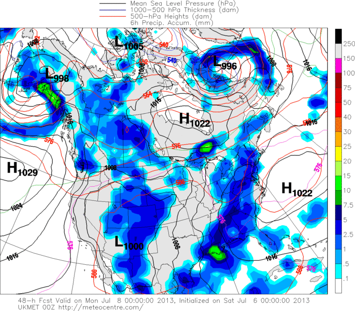
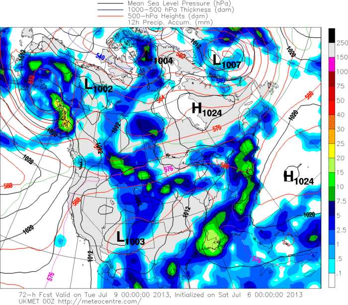
At least the 0zUKMET came in a bit wetter for Texas..

0zUKMET 48hr Forecast (Sunday Afternoon)
Image

0zUKMET 72hr Rainfall Forecast (Monday)
Image
0 likes   
The following post is NOT an official forecast and should not be used as such. It is just the opinion of the poster and may or may not be backed by sound meteorological data. It is NOT endorsed by any professional institution including storm2k.org For Official Information please refer to the NHC and NWS products.

ozonepete
Professional-Met
Professional-Met
Posts: 4743
Joined: Mon Sep 07, 2009 3:23 pm
Location: From Ozone Park, NYC / Now in Brooklyn, NY

Re: ATL: INVEST 94L - Discussion

#73 Postby ozonepete » Sat Jul 06, 2013 12:14 am

djmikey wrote:
ozonepete wrote:Sorry to say the 8 PM runs are in and the models aren't doing anything with it, other than some rain on the Texas coast that doesn't work very far in to the interior of the state. The latest satellite loops also show a sheared mess, unfortunately. The chances for a big rainmaker are really going downhill. :(

Personal Forecast Disclaimer: The posts in this forum are NOT official forecast and should not be used as such. They are just the opinion of the poster and may or may not be backed by sound meteorological data. They are NOT endorsed by any professional institution or storm2k.org. For official information, please refer to the NHC and NWS products.


NOT what us here in TX want to hear Pete! We have been burned so many times these past few years. (hence the severe drought) :cry:


I hear you. But it really looks like some of these systems are going to make it in there this hurricane season. There's a lot of activity out there already and a lot more expected. So if the Bermuda high keeps extending westward for the next couple of months at least one or two of these storms should make it to Texas. You guys are due. Actually way overdue. We are all rooting for you. :)
0 likes   

User avatar
southerngale
Retired Staff
Retired Staff
Posts: 27420
Joined: Thu Oct 10, 2002 1:27 am
Location: Southeast Texas (Beaumont area)

Re: ATL: INVEST 94L - Discussion

#74 Postby southerngale » Sat Jul 06, 2013 12:21 am

Well, for the most part, we have been fortunate in the Beaumont area. I know that not every area in SE TX can say that and you may be in one of the drier spots, djmikey, but where I live, it's only been dry the past few weeks (although we are officially in a drought). I have been hit with a few strong storms, but that was a few weeks ago and even I could use some rain now. Per NWS, our chances are pretty good with this system, but you know how that goes... we sometimes get more rain when it ISN'T predicted, and I haven't looked at any recent model runs, but what ozonepete said wasn't encouraging. So I guess we wait and see. Image Pretty much all of Texas needs rain.
0 likes   
Please support Storm2k by making a donation today. It is greatly appreciated! Click here: Image

Image my Cowboys Image my RocketsImage my Astros

User avatar
southerngale
Retired Staff
Retired Staff
Posts: 27420
Joined: Thu Oct 10, 2002 1:27 am
Location: Southeast Texas (Beaumont area)

#75 Postby southerngale » Sat Jul 06, 2013 12:34 am

0z UKMET wants to give Louisiana a lot more rain than Texas.
0 likes   
Please support Storm2k by making a donation today. It is greatly appreciated! Click here: Image

Image my Cowboys Image my RocketsImage my Astros

ozonepete
Professional-Met
Professional-Met
Posts: 4743
Joined: Mon Sep 07, 2009 3:23 pm
Location: From Ozone Park, NYC / Now in Brooklyn, NY

Re: ATL: INVEST 94L - Discussion

#76 Postby ozonepete » Sat Jul 06, 2013 12:37 am

Hey, southerngale! Happy 2013 season. :) Well even if this one doesn't pan out I really think this season looks good for you. A strong Bermuda high like this one eventually helps steer systems further west. A lot of easterly waves are marching off of the African coast already (very early for that!) and in the next few weeks many of them should make it across intact towards your area. So lets keep our fingers crossed. You guys are, after all, in the true hurricane belt from Beaumont to Brownsville so sooner or later you'll get the moisture. We just want 'em to all be weak and very wet. :wink:
0 likes   

User avatar
southerngale
Retired Staff
Retired Staff
Posts: 27420
Joined: Thu Oct 10, 2002 1:27 am
Location: Southeast Texas (Beaumont area)

#77 Postby southerngale » Sat Jul 06, 2013 12:46 am

Happy Hurricane Season, ozonepete! lol
This looked like a great solution, for at least some parts of Texas, to the drought, since it should be weak, but eh, it might not happen. It's kind of weird how much of a drought Texas has seen the past few years since it's usually so wet here. I guess it's feast or famine.
With all the hurricanes that have devastated Texas the past several years, I hope it's just a rainmaker that finally rids Texas of this incessant drought.
0 likes   
Please support Storm2k by making a donation today. It is greatly appreciated! Click here: Image

Image my Cowboys Image my RocketsImage my Astros

djmikey
Tropical Storm
Tropical Storm
Posts: 151
Joined: Tue Jul 20, 2010 6:04 pm
Location: Beaumont, TX

Re:

#78 Postby djmikey » Sat Jul 06, 2013 12:48 am

southerngale wrote:0z UKMET wants to give Louisiana a lot more rain than Texas.

:cry: then :grr: then :cry: So once again, we get burned. Keeping fingers crossed for this this season though. Just need a weak system with tons of rain for Texas.
0 likes   

User avatar
southerngale
Retired Staff
Retired Staff
Posts: 27420
Joined: Thu Oct 10, 2002 1:27 am
Location: Southeast Texas (Beaumont area)

#79 Postby southerngale » Sat Jul 06, 2013 1:00 am

That's just one run of one model. They're kind of all over the place. NHC latest outlook says it should move northward toward the Texas and Lousiana coast. We should get some rain, and maybe a lot of it.
0 likes   
Please support Storm2k by making a donation today. It is greatly appreciated! Click here: Image

Image my Cowboys Image my RocketsImage my Astros

djmikey
Tropical Storm
Tropical Storm
Posts: 151
Joined: Tue Jul 20, 2010 6:04 pm
Location: Beaumont, TX

Re:

#80 Postby djmikey » Sat Jul 06, 2013 1:19 am

southerngale wrote:That's just one run of one model. They're kind of all over the place. NHC latest outlook says it should move northward toward the Texas and Lousiana coast. We should get some rain, and maybe a lot of it.

True. The way things are looking, our little teeny tiny corner of the state might get the only moisture from this thing. Beaumont Golden Triangle area. :D but :-( Image
Uploaded with ImageShack.us
Image
Uploaded with ImageShack.us
0 likes   


Return to “2013”

Who is online

Users browsing this forum: No registered users and 69 guests