ATL: INVEST 94L - Discussion
Moderator: S2k Moderators

Re: ATL: INVEST 94L - Discussion
Buoy 42361 west wind? 
0 likes
The following post is NOT an official forecast and should not be used as such. It is just the opinion of the poster and may or may not be backed by sound meteorological data. It is NOT endorsed by any professional institution including storm2k.org For Official Information please refer to the NHC and NWS products.
-
Rgv20

- S2K Supporter

- Posts: 2456
- Age: 37
- Joined: Wed Jan 05, 2011 5:42 pm
- Location: Edinburg/McAllen Tx
Hopefully this forecast pans out! 
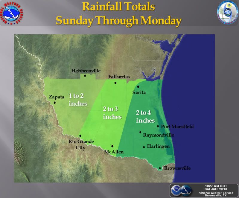
Low pressure combined with plenty of tropical moisture will work its way towards the Rio Grande Valley and Deep South Texas this weekend, increasing the chances for showers and thunderstorms across the area. Coastal counties are likely to see the greatest rainfall totals through Monday. Slower or heavier activity will have the ability to produce locally heavy rainfall with nuisance flooding in poorly draining or low-lying areas.

Low pressure combined with plenty of tropical moisture will work its way towards the Rio Grande Valley and Deep South Texas this weekend, increasing the chances for showers and thunderstorms across the area. Coastal counties are likely to see the greatest rainfall totals through Monday. Slower or heavier activity will have the ability to produce locally heavy rainfall with nuisance flooding in poorly draining or low-lying areas.
0 likes
The following post is NOT an official forecast and should not be used as such. It is just the opinion of the poster and may or may not be backed by sound meteorological data. It is NOT endorsed by any professional institution including storm2k.org For Official Information please refer to the NHC and NWS products.
-
Rgv20
- S2K Supporter
- Posts: 2456
- Age: 37
- Joined: Wed Jan 05, 2011 5:42 pm
- Location: Edinburg/McAllen Tx
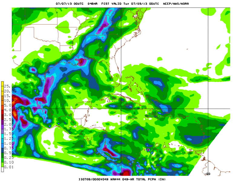
0zNAM Total Rainfall forecast thru 48hrs (Monday Night) shows some decent totals in Deep South Texas

0 likes
The following post is NOT an official forecast and should not be used as such. It is just the opinion of the poster and may or may not be backed by sound meteorological data. It is NOT endorsed by any professional institution including storm2k.org For Official Information please refer to the NHC and NWS products.


Re:
Dean4Storms wrote:I might be looking at loops to long, I don't know. But I think I see a lower level circulation way out near 25.5N 89.5W or it could be at mid level. Does anyone else see what I'm seeing?
Maybe now more like 26N drifting north. Been watching it most of the day.
Must be a mid level vort, I don't see any surface obs indicating a surface low there.
I see what you are talking about....right on queue the convection fizzled tonight but I see a MLC out there....convection trying to make a come back over it...
0 likes

Re: ATL: INVEST 94L - Discussion
tailgater wrote:Buoy 42361 west wind?
Something brewing perhaps?
0 likes
-
HurricaneBrain

- S2K Supporter
- Posts: 430
- Joined: Thu Jun 30, 2011 2:07 pm
- Location: Beaumont, TX

Re: ATL: INVEST 94L - Discussion
Radar and satellite loop appears to show that we now have a vorticity developing east of Corpus Christi but by looking at surface reports if it is at the surface it is very weak, there is a buoy just south of this area of vorticity that has been reporting SW & W winds all morning long. Running out of time over water for anything to get going at the surface, IMO.
0 likes
-
vbhoutex

- Storm2k Executive

- Posts: 28975
- Age: 72
- Joined: Wed Oct 09, 2002 11:31 pm
- Location: Spring Branch area, Houston, TX
- Contact:
Re: ATL: INVEST 94L - Discussion
YAWN!!! That is how I feel about 94L. So far it has been less than a yawner here in my area of Houston on the West side. Maybe the moisture will continue to move N and make it this far inland tomorrow. We REALLY need the rain. I know, watch out what you ask for.
0 likes
Skywarn, C.E.R.T.
Please click below to donate to STORM2K to help with the expenses of keeping the site going:

Please click below to donate to STORM2K to help with the expenses of keeping the site going:

Re: ATL: INVEST 94L - Discussion
Is 94L washed up? Has it become just an area of clouds and some moisture. Had a slight drizzle on and off all day here - very cloudy.
0 likes
-
southerngale

- Retired Staff

- Posts: 27420
- Joined: Thu Oct 10, 2002 1:27 am
- Location: Southeast Texas (Beaumont area)
Re: ATL: INVEST 94L - Discussion
vbhoutex wrote:YAWN!!! That is how I feel about 94L. So far it has been less than a yawner here in my area of Houston on the West side. Maybe the moisture will continue to move N and make it this far inland tomorrow. We REALLY need the rain. I know, watch out what you ask for.
Same here. High rain chances today and not even a drop!
0 likes
Please support Storm2k by making a donation today. It is greatly appreciated! Click here:
 my Cowboys my Rockets my Astros
my Cowboys my Rockets my Astros
Re: ATL: INVEST 94L - Discussion
94L was nothing but a joke! Not a drop here in Beaumont! 3"-4" was way over done!!! I dont think anyone in TX got .10" or more! Local met just mentionec 50% for us today in Beaumont...lol....Im not holding my breath!
0 likes
-
StormTracker

- S2K Supporter
- Posts: 2902
- Age: 57
- Joined: Thu Jun 29, 2006 6:06 am
- Location: Quail Heights(Redlands), FL.
Re: ATL: INVEST 94L - Discussion
ozonepete wrote:StormTracker wrote:Can any pro-met make any sense of this or should I be looking at another chart? Ozone or wxman57, maybe one of you can elaborate on this? Does this show the Bermuda High sliding further west?
http://www.weathercharts.org/noaa-charts.htm#t96-mslp
Yeah those charts are fine - I really like them. Only problem is they don't go far west enough. But the 500 mb is the key chart and that does show the ridge building westward. Hopefully it is weak enough on the bottom side that it allows 94L to get north enough to cover most of Texas with rain. You can use these charts from NWS to watch it: http://mag.ncep.noaa.gov/
Choose a model - GFS is fine. I personally don't care for the NAM. Then choose a time 12UTC is the 8AM run and is available around 11:30 AM EDT. The 00UTC run is the 8PM run and available around 11:30PM. choose namer (north America) and the choose 500_rh_ht (Relative Humidity and heights). Choose the loop and then you can watch the 500 mb ridge build westward over the next few days. Watch the moist, high RH air at mid-levels shifting westward. Nice for Texas if it holds!
Thanks OP! I really appreciate you for that! I love the fact that I can learn so much from you guys here @ Storm2k!
0 likes
Something's wrong when you regret, things that haven't happened yet!

Re: ATL: INVEST 94L - Discussion
Finally got some rain out this thing! Not even an inch, but we need whatever we can get.
0 likes
Who is online
Users browsing this forum: No registered users and 43 guests