WTPN32 PGTW 021500
MSGID/GENADMIN/JOINT TYPHOON WRNCEN PEARL HARBOR HI//
SUBJ/TROPICAL CYCLONE WARNING//
RMKS/
1. TYPHOON 11W (DAMREY) WARNING NR 020
02 ACTIVE TROPICAL CYCLONES IN NORTHWESTPAC
MAX SUSTAINED WINDS BASED ON ONE-MINUTE AVERAGE
WIND RADII VALID OVER OPEN WATER ONLY
---
WARNING POSITION:
021200Z --- NEAR 34.6N 120.2E
MOVEMENT PAST SIX HOURS - 295 DEGREES AT 18 KTS
POSITION ACCURATE TO WITHIN 025 NM
POSITION BASED ON CENTER LOCATED BY SATELLITE
PRESENT WIND DISTRIBUTION:
MAX SUSTAINED WINDS - 065 KT, GUSTS 080 KT
WIND RADII VALID OVER OPEN WATER ONLY
RADIUS OF 050 KT WINDS - 025 NM NORTHEAST QUADRANT
025 NM SOUTHEAST QUADRANT
025 NM SOUTHWEST QUADRANT
025 NM NORTHWEST QUADRANT
RADIUS OF 034 KT WINDS - 090 NM NORTHEAST QUADRANT
070 NM SOUTHEAST QUADRANT
100 NM SOUTHWEST QUADRANT
110 NM NORTHWEST QUADRANT
REPEAT POSIT: 34.6N 120.2E
---
FORECASTS:
12 HRS, VALID AT:
030000Z --- 35.6N 117.8E
MAX SUSTAINED WINDS - 045 KT, GUSTS 055 KT
WIND RADII VALID OVER OPEN WATER ONLY
VECTOR TO 24 HR POSIT: 300 DEG/ 05 KTS
---
24 HRS, VALID AT:
031200Z --- 36.1N 116.7E
MAX SUSTAINED WINDS - 030 KT, GUSTS 040 KT
WIND RADII VALID OVER OPEN WATER ONLY
DISSIPATING AS A SIGNIFICANT TROPICAL CYCLONE OVER LAND
VECTOR TO 36 HR POSIT: 335 DEG/ 04 KTS
---
36 HRS, VALID AT:
040000Z --- 36.9N 116.2E
MAX SUSTAINED WINDS - 020 KT, GUSTS 030 KT
WIND RADII VALID OVER OPEN WATER ONLY
DISSIPATED AS A SIGNIFICANT TROPICAL CYCLONE OVER LAND
---
REMARKS:
021500Z POSITION NEAR 34.9N 119.6E.
TYPHOON 11W (DAMREY), LOCATED APPROXIMATELY 365 NM SOUTH-SOUTHEAST OF
BEIJING, CHINA, HAS TRACKED NORTHWESTWARD AT 21 KNOTS OVER THE PAST
SIX HOURS. MAXIMUM SIGNIFICANT WAVE HEIGHT AT 021200Z IS 28 FEET.
NEXT WARNINGS AT 022100Z. REFER TO TROPICAL STORM 10W (SAOLA)
WARNINGS (WTPN31 PGTW) FOR SIX-HOURLY UPDATES. //
NNNN

WDPN32 PGTW 021500
MSGID/GENADMIN/JOINT TYPHOON WRNCEN PEARL HARBOR HI//
SUBJ/PROGNOSTIC REASONING FOR TYPHOON 11W (DAMREY) WARNING NR 20//
RMKS//
1. FOR METEOROLOGISTS.
2. 6 HOUR SUMMARY AND ANALYSIS.
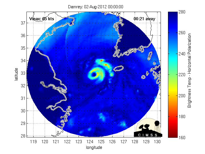
TYPHOON (TY) 11W (DAMREY), LOCATED APPROXIMATELY 365 NM
SOUTH-SOUTHEAST OF BEIJING, CHINA, HAS TRACKED NORTHWESTWARD AT 21
KNOTS OVER THE PAST SIX HOURS. ANIMATED ENHANCED INFRARED (EIR)
SATELLITE IMAGERY SHOWS THE SYSTEM HAS MAINTAINED A 15-NM RAGGED EYE
AS CONVECTIVE TOPS HAVE WARMED, AN INDICATION OF WEAKENING. THE
CURRENT POSITION IS BASED ON THE ANIMATED EIR IMAGERY WITH HIGH
CONFIDENCE. THE CURRENT INTENSITY IS AVERAGED FROM DVORAK ESTIMATES
FROM PGTW AND KNES. UPPER-LEVEL ANALYSIS INDICATES THE SYSTEM IS 10
DEGREES SOUTH OF A RIDGE AXIS IN AN AREA OF LIGHT TO MODERATE (10-20
KNOT) EASTERLY VERTICAL WIND SHEAR. THE CYCLONE IS TRACKING ALONG THE
SOUTHERN PERIPHERY OF A DEEP-LAYERED SUBTROPICAL RIDGE (STR) ANCHORED
OVER KYUSHU, JAPAN.
3. FORECAST REASONING.
A. THERE IS NO SIGNIFICANT CHANGE TO THE FORECAST PHILOSOPHY
FROM THE PREVIOUS PROGNOSTIC REASONING.
B. TY 11W IS EXPECTED TO MAKE LANDFALL IN THE NEXT FEW HOURS OVER
EASTERN CHINA THEN WILL RAPIDLY DECAY DUE TO FRICTIONAL EFFECTS FROM
THE RUGGED TERRAIN. TY DAMREY WILL DISSIPATE AS A SIGNIFICANT
TROPICAL CYCLONE OVER LAND BY TAU 36. MODEL GUIDANCE WIDELY DIVERGE
WITH MOST MODELS SHOWING AN UNLIKELY TRACK INTO THE STR. ECMWF IS THE
SOLE LEFT OUTLIER. THIS TRACK FORECAST IS JUST TO THE LEFT OF
CONSENSUS. THERE IS LOW CONFIDENCE IN THE TRACK FORECAST DUE TO THE
BIG DISPARITY IN THE MODEL AIDS. //
NNNN