ATL: BARRY - Post-Tropical
Moderator: S2k Moderators
-
TropicalAnalystwx13

- Category 5

- Posts: 2109
- Age: 26
- Joined: Tue Jul 19, 2011 8:20 pm
- Location: Wilmington, NC
- Contact:
-
ozonepete
- Professional-Met

- Posts: 4743
- Joined: Mon Sep 07, 2009 3:23 pm
- Location: From Ozone Park, NYC / Now in Brooklyn, NY
Re: ATL: INVEST 93L - Discussion
Hurricaneman wrote:The perfect analog for 93L has to be 2005 Bret, had little time to develop over the BOC but just enough time to become a minimal tropical storm which I think this system may pull off at best
Here's a really good analog. TS Harvey from 2011. I remember how we had long discussions about whether it would get to TS so close to the coast and it did. It did it with the center moving right along the coast in this exact region. Look how similar. The main difference here is that this one will move more WNW instead of west.


0 likes
-
Aric Dunn
- Category 5
- Posts: 21228
- Age: 41
- Joined: Sun Sep 19, 2004 9:58 pm
- Location: Ready for the Chase.
- Contact:
yeah cycloneye the convection off to the appears to drawing.the mlc/llc to it has bit more of northerly component the last several hours it looks like it might be off shore in the next 6 hours or so and ride the coast kr be pulled slightly farther north into the convection over the nw carrib
0 likes
Note: If I make a post that is brief. Please refer back to previous posts for the analysis or reasoning. I do not re-write/qoute what my initial post said each time.
If there is nothing before... then just ask
Space & Atmospheric Physicist, Embry-Riddle Aeronautical University,
I believe the sky is falling...
If there is nothing before... then just ask
Space & Atmospheric Physicist, Embry-Riddle Aeronautical University,
I believe the sky is falling...
-
ozonepete
- Professional-Met
- Posts: 4743
- Joined: Mon Sep 07, 2009 3:23 pm
- Location: From Ozone Park, NYC / Now in Brooklyn, NY
Re: ATL: INVEST 93L - Discussion
YeaH Aric, I could see the center getting north of the coast tonight and staying over water until Belize. Has a window to make TD or even TS if it moves slowly, but might be moving too fast.
0 likes
-
Aric Dunn
- Category 5
- Posts: 21228
- Age: 41
- Joined: Sun Sep 19, 2004 9:58 pm
- Location: Ready for the Chase.
- Contact:
Re: ATL: INVEST 93L - Discussion
ozonepete wrote::uarrow:
YeaH Aric, I could see the center getting north of the coast tonight and staying over water until Belize. Has a window to make TD or even TS if it moves slowly, but might be moving too fast.
If you look at the developing feeder band its quite clear whats happening all that convection that is building to the north of is pulling the low to mid level circ north into it. the llc may end up developing or relocating of sorts in or under this recent burst of convection.

0 likes
Note: If I make a post that is brief. Please refer back to previous posts for the analysis or reasoning. I do not re-write/qoute what my initial post said each time.
If there is nothing before... then just ask
Space & Atmospheric Physicist, Embry-Riddle Aeronautical University,
I believe the sky is falling...
If there is nothing before... then just ask
Space & Atmospheric Physicist, Embry-Riddle Aeronautical University,
I believe the sky is falling...
-
cycloneye

- Admin

- Posts: 139331
- Age: 67
- Joined: Thu Oct 10, 2002 10:54 am
- Location: San Juan, Puerto Rico
Re: ATL: INVEST 93L - Discussion
Since this morning when 93L was up,there has not been any Best Track positions nor 93L has been on the main NRL site because of a malfunction at the ATCF site. But the other site of Best Track files is working.
AL, 93, 2013061512, , BEST, 0, 125N, 780W, 20, 1009, DB, 0, , 0, 0, 0, 0,
AL, 93, 2013061518, , BEST, 0, 130N, 794W, 20, 1009, DB, 0, , 0, 0, 0, 0,
AL, 93, 2013061600, , BEST, 0, 134N, 805W, 20, 1009, DB, 0, , 0, 0, 0, 0,
AL, 93, 2013061606, , BEST, 0, 137N, 816W, 20, 1009, DB, 0, , 0, 0, 0, 0,
AL, 93, 2013061612, , BEST, 0, 141N, 826W, 20, 1009, DB, 0, , 0, 0, 0, 0, 1011, 150, 90, 0, 0, L, 0, , 0, 0, INVEST, M,
AL, 93, 2013061618, , BEST, 0, 146N, 837W, 20, 1009, DB, 34, NEQ, 0, 0, 0, 0, 1011, 150, 90, 0, 0, L, 0, , 0, 0, INVEST M,
ftp://ftp.nhc.noaa.gov/atcf/btk/
0 likes
Visit the Caribbean-Central America Weather Thread where you can find at first post web cams,radars
and observations from Caribbean basin members Click Here
and observations from Caribbean basin members Click Here
-
ozonepete
- Professional-Met
- Posts: 4743
- Joined: Mon Sep 07, 2009 3:23 pm
- Location: From Ozone Park, NYC / Now in Brooklyn, NY
Re: ATL: INVEST 93L - Discussion
Aric Dunn wrote:ozonepete wrote::uarrow:
YeaH Aric, I could see the center getting north of the coast tonight and staying over water until Belize. Has a window to make TD or even TS if it moves slowly, but might be moving too fast.
If you look at the developing feeder band its quite clear whats happening all that convection that is building to the north of is pulling the low to mid level circ north into it. the llc may end up developing or relocating of sorts in or under this recent burst of convection.
http://imageshack.us/a/img211/7206/gdl.jpg
Yes, I see it clearly now. I was just going to post an image with a circle almost exactly where you have it. I expect the LLC/MLC to consolidate right in that area. If that happens it has more than enough time (and space) to make TD or TS before hitting Belize. The outflow is really healthy now as well so convection should keep increasing...
0 likes
-
Aric Dunn
- Category 5
- Posts: 21228
- Age: 41
- Joined: Sun Sep 19, 2004 9:58 pm
- Location: Ready for the Chase.
- Contact:
Hey ozonepete... new image in.. right at the end of my red line... but on the new image you see the low level yellow clouds... check out the hook developing.... may be trying to wrap up fast.
run the loop.. at about 16.71° N Longitude= 83.43° W
http://www.ssd.noaa.gov/PS/TROP/floater ... -long.html
I would not be surprised if it went to 40 or 50 %
run the loop.. at about 16.71° N Longitude= 83.43° W
http://www.ssd.noaa.gov/PS/TROP/floater ... -long.html
I would not be surprised if it went to 40 or 50 %
0 likes
Note: If I make a post that is brief. Please refer back to previous posts for the analysis or reasoning. I do not re-write/qoute what my initial post said each time.
If there is nothing before... then just ask
Space & Atmospheric Physicist, Embry-Riddle Aeronautical University,
I believe the sky is falling...
If there is nothing before... then just ask
Space & Atmospheric Physicist, Embry-Riddle Aeronautical University,
I believe the sky is falling...
-
ozonepete
- Professional-Met
- Posts: 4743
- Joined: Mon Sep 07, 2009 3:23 pm
- Location: From Ozone Park, NYC / Now in Brooklyn, NY
Re: ATL: INVEST 93L - Discussion
Aric, I definitely see it, though I have it a little behind you at about 16.2N 83.5W.
Edited the position.
Edited the position.
0 likes
-
Aric Dunn
- Category 5
- Posts: 21228
- Age: 41
- Joined: Sun Sep 19, 2004 9:58 pm
- Location: Ready for the Chase.
- Contact:
Re: ATL: INVEST 93L - Discussion
ozonepete wrote:Aric, I definitely see it, though I have it a little behind you at about 16.2N 83.5W.
Edited the position.
yeah general area.. that coord from the nasa site and my mouse lol and that hook would the nw side of the circ so your coord are prob where a llc may be developing.
0 likes
Note: If I make a post that is brief. Please refer back to previous posts for the analysis or reasoning. I do not re-write/qoute what my initial post said each time.
If there is nothing before... then just ask
Space & Atmospheric Physicist, Embry-Riddle Aeronautical University,
I believe the sky is falling...
If there is nothing before... then just ask
Space & Atmospheric Physicist, Embry-Riddle Aeronautical University,
I believe the sky is falling...
-
ozonepete
- Professional-Met
- Posts: 4743
- Joined: Mon Sep 07, 2009 3:23 pm
- Location: From Ozone Park, NYC / Now in Brooklyn, NY
Re: ATL: INVEST 93L - Discussion
Actually, with my edited position we basically have it the same. I agree they should go with 50%. This area has a history of producing really fast developers when shear is low. Likely due to the geographic contours and really warm SSTs.
0 likes
-
Aric Dunn
- Category 5
- Posts: 21228
- Age: 41
- Joined: Sun Sep 19, 2004 9:58 pm
- Location: Ready for the Chase.
- Contact:
Re: ATL: INVEST 93L - Discussion
ozonepete wrote:Actually, with my edited position we basically have it the same. I agree they should go with 50%. This area has a history of producing really fast developers when shear is low. Likely due to the geographic contours and really warm SSTs.
Yeah pretty outflow atm..
0 likes
Note: If I make a post that is brief. Please refer back to previous posts for the analysis or reasoning. I do not re-write/qoute what my initial post said each time.
If there is nothing before... then just ask
Space & Atmospheric Physicist, Embry-Riddle Aeronautical University,
I believe the sky is falling...
If there is nothing before... then just ask
Space & Atmospheric Physicist, Embry-Riddle Aeronautical University,
I believe the sky is falling...
-
Hurricaneman

- Category 5
- Posts: 7284
- Age: 43
- Joined: Tue Aug 31, 2004 3:24 pm
- Location: central florida
Re: ATL: INVEST 93L - Discussion
I currently put at least a MLC at 16.34N 83.47W but its probably a loose circulation at the surface if there is one so maybe me, Aric and Ozonepete are all right in the position and its possible that the system is still getting a slight pull to the north by the exiting trough in which this will become a more W track to north of due west
0 likes
-
ozonepete
- Professional-Met
- Posts: 4743
- Joined: Mon Sep 07, 2009 3:23 pm
- Location: From Ozone Park, NYC / Now in Brooklyn, NY
Re: ATL: INVEST 93L - Discussion
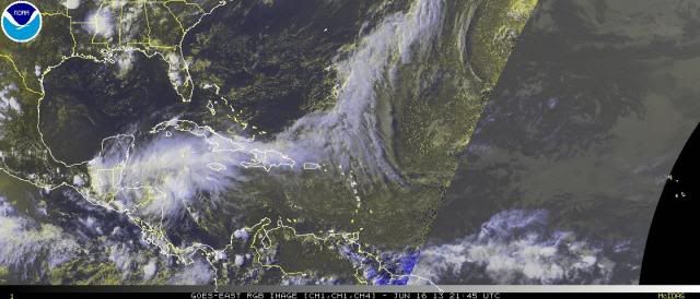
Yes, hurricaneman, and I can really see an MLC developing there as well. Here's another image to show the outflow. Pretty impressive. It has what it needs to develop pretty rapidly now.

0 likes
-
ozonepete
- Professional-Met
- Posts: 4743
- Joined: Mon Sep 07, 2009 3:23 pm
- Location: From Ozone Park, NYC / Now in Brooklyn, NY
Re: ATL: INVEST 93L - Discussion
Aric Dunn wrote:ozonepete wrote:Actually, with my edited position we basically have it the same. I agree they should go with 50%. This area has a history of producing really fast developers when shear is low. Likely due to the geographic contours and really warm SSTs.
Yeah pretty outflow atm..
From that chart it looks like an anti-cyclone may be developing overhead. It's almost there already.
Very impressive for June!
0 likes
-
Hurricaneman
- Category 5
- Posts: 7284
- Age: 43
- Joined: Tue Aug 31, 2004 3:24 pm
- Location: central florida
Re: ATL: INVEST 93L - Discussion
If this keeps its current organization going, another analog if it gets far enough north could be a weaker version of Alex from 2010, but not as far north in the BOC
0 likes
-
Aric Dunn
- Category 5
- Posts: 21228
- Age: 41
- Joined: Sun Sep 19, 2004 9:58 pm
- Location: Ready for the Chase.
- Contact:
Re: ATL: INVEST 93L - Discussion
ozonepete wrote:Aric Dunn wrote:ozonepete wrote:Actually, with my edited position we basically have it the same. I agree they should go with 50%. This area has a history of producing really fast developers when shear is low. Likely due to the geographic contours and really warm SSTs.
Yeah pretty outflow atm..
From that chart it looks like an anti-cyclone may be developing overhead. It's almost there already.
Very impressive for June!
yeah! and pressures are falling in the area around 1006 to 1008
0 likes
Note: If I make a post that is brief. Please refer back to previous posts for the analysis or reasoning. I do not re-write/qoute what my initial post said each time.
If there is nothing before... then just ask
Space & Atmospheric Physicist, Embry-Riddle Aeronautical University,
I believe the sky is falling...
If there is nothing before... then just ask
Space & Atmospheric Physicist, Embry-Riddle Aeronautical University,
I believe the sky is falling...
-
ozonepete
- Professional-Met
- Posts: 4743
- Joined: Mon Sep 07, 2009 3:23 pm
- Location: From Ozone Park, NYC / Now in Brooklyn, NY
Re: ATL: INVEST 93L - Discussion
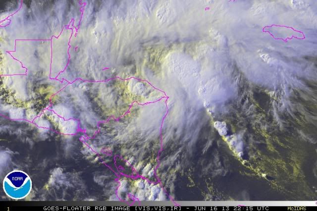
Look at the latest rgb. That convergence zone / inflow band you noted, Aric, is blowing up convection along it and look at the explosion of convection near where we expect the center is forming/consolidating. Wow!

0 likes
-
Aric Dunn
- Category 5
- Posts: 21228
- Age: 41
- Joined: Sun Sep 19, 2004 9:58 pm
- Location: Ready for the Chase.
- Contact:
Re: ATL: INVEST 93L - Discussion
ozonepete wrote:Look at the latest rgb. That convergence zone / inflow band you noted, Aric, is blowing up convection along it and look at the explosion of convection near where we expect the center is forming/consolidating. Wow!
http://i189.photobucket.com/albums/z174/philnyc_2007/satrgb2013-06-162215_zps5cc945bd.jpg
looking at the loop notice the convection right on the coast of the north east side of Honduras its nearly stationary and almost back building to the ese.. meaning the center may actually be plenty offshore where we have been saying it.
0 likes
Note: If I make a post that is brief. Please refer back to previous posts for the analysis or reasoning. I do not re-write/qoute what my initial post said each time.
If there is nothing before... then just ask
Space & Atmospheric Physicist, Embry-Riddle Aeronautical University,
I believe the sky is falling...
If there is nothing before... then just ask
Space & Atmospheric Physicist, Embry-Riddle Aeronautical University,
I believe the sky is falling...
-
ouragans

- Category 1

- Posts: 466
- Age: 52
- Joined: Sun Jun 12, 2011 12:09 pm
- Location: Abymes, Guadeloupe F.W.I
- Contact:
Re: ATL: INVEST 93L - Discussion
cycloneye wrote:the other site of Best Track files is working.
ftp://ftp.nhc.noaa.gov/atcf/btk/
OK this explains why tropicalatlantic.com didnot reflect 93L, and WUnderground did... Thanks for the info
0 likes
Personal forecast disclaimer
This post is a personal point of view, not an information. Please refer to official statements for life-threatening decisions.
David '79, Frederic '79, Hugo '89, Iris, Luis & Marilyn '95, Georges '98, Lenny '99, Dean '07, Irma '17, Maria '17, Fiona '22, Philippe '23, Tammy '23
16°13'33.3,"6N -61°36'39.5"W
Who is online
Users browsing this forum: No registered users and 6 guests