

ATL: BERTHA - Models
Moderator: S2k Moderators

Re: ATL: INVEST 93L - Models
Looking at the SSD positions today this thing has dipped almost half a degree in latitude. Were any of the models showing this. All I know is tomorrow it better start gaining some latitiude.
29/0545 UTC 9.9N 37.3W T1.0/1.0 93L
29/2345 UTC 9.5N 41.2W T1.0/1.5 93L
29/0545 UTC 9.9N 37.3W T1.0/1.0 93L
29/2345 UTC 9.5N 41.2W T1.0/1.5 93L
0 likes
The following post is NOT an official forecast and should not be used as such. It is just the opinion of the poster and may or may not be backed by sound meteorological data. It is NOT endorsed by any professional institution including storm2k.org For Official Information please refer to the NHC and NWS products.
-
gatorcane

- S2K Supporter

- Posts: 23499
- Age: 46
- Joined: Sun Mar 13, 2005 3:54 pm
- Location: Boca Raton, FL
Seems to me the ECMWF predicted this system the best from the get-go and was never too bullish on this system, until the past couple of runs which got it up to T.S. status briefly.
This past weekend, however, while the GFS was blowing this system up, the ECMWF was showing pretty much what we are seeing now - a wave that moves W or WSW and eventually dies off before the leewards.
This past weekend, however, while the GFS was blowing this system up, the ECMWF was showing pretty much what we are seeing now - a wave that moves W or WSW and eventually dies off before the leewards.
0 likes
Re:
gatorcane wrote:Seems to me the ECMWF predicted this system the best from the get-go and was never too bullish on this system, until the past couple of runs which got it up to T.S. status briefly.
This past weekend, however, while the GFS was blowing this system up, the ECMWF was showing pretty much what we are seeing now - a wave that moves W or WSW and eventually dies off before the leewards.
Good point Gator and it showed it struggling in this area for several runs.
0 likes
The following post is NOT an official forecast and should not be used as such. It is just the opinion of the poster and may or may not be backed by sound meteorological data. It is NOT endorsed by any professional institution including storm2k.org For Official Information please refer to the NHC and NWS products.
-
Hurricane Alexis

- Category 2

- Posts: 683
- Age: 27
- Joined: Thu Jun 14, 2012 7:59 pm
- Location: Miami,Florida
Re: ATL: INVEST 93L - Models
00z GFS kills it off quickly north of the islands.
0 likes
Personal Forecast Disclaimer:
The posts in this forum are NOT official forecast and should not be used as such. They are just the opinion of the poster and may or may not be backed by sound meteorological data. They are NOT endorsed by any professional institution or storm2k.org. For official information, please refer to the NHC and NWS products.
The posts in this forum are NOT official forecast and should not be used as such. They are just the opinion of the poster and may or may not be backed by sound meteorological data. They are NOT endorsed by any professional institution or storm2k.org. For official information, please refer to the NHC and NWS products.
Re: ATL: INVEST 93L - Models
Amazing how the Euro which once showed nothing then dissipation in the Bahamas now shows it staying intact through the entire run and now the GFS which was the most bullish has significantly backed off looks to open it up north of the islands.
The common theme I see is that the ridge only extends to about 75W. It will most likely feel the weakness even if it is weak system.
The common theme I see is that the ridge only extends to about 75W. It will most likely feel the weakness even if it is weak system.
0 likes
The following post is NOT an official forecast and should not be used as such. It is just the opinion of the poster and may or may not be backed by sound meteorological data. It is NOT endorsed by any professional institution including storm2k.org For Official Information please refer to the NHC and NWS products.
Re: ATL: INVEST 93L - Models
One thing I have noticed is that 50W is the mark where the models start to change the heading to WNW. It will be interesting to see if that happens later today.
0 likes
The following post is NOT an official forecast and should not be used as such. It is just the opinion of the poster and may or may not be backed by sound meteorological data. It is NOT endorsed by any professional institution including storm2k.org For Official Information please refer to the NHC and NWS products.


CMC still develops this system on its 12z run and takes it northwards and recurves it. 12z HWRF also still develops, but both models IMO are not doing a great job with the SAL.
0 likes
Personal Forecast Disclaimer:
The posts in this forum are NOT official forecast and should not be used as such. They are just the opinion of the poster and may or may not be backed by sound meteorological data. They are NOT endorsed by any professional institution or storm2k.org. For official information, please refer to the NHC and NWS products
The posts in this forum are NOT official forecast and should not be used as such. They are just the opinion of the poster and may or may not be backed by sound meteorological data. They are NOT endorsed by any professional institution or storm2k.org. For official information, please refer to the NHC and NWS products

Re: ATL: INVEST 93L - Models
I never give the NAVGEM much credit but looking through 2 days of runs it actually did quite good with this system. It never really developed it much even when it looked its best.
0 likes
The following post is NOT an official forecast and should not be used as such. It is just the opinion of the poster and may or may not be backed by sound meteorological data. It is NOT endorsed by any professional institution including storm2k.org For Official Information please refer to the NHC and NWS products.
-
gatorcane
- S2K Supporter
- Posts: 23499
- Age: 46
- Joined: Sun Mar 13, 2005 3:54 pm
- Location: Boca Raton, FL
Re: ATL: INVEST 93L - Models
blp wrote:I never give the NAVGEM much credit but looking through 2 days of runs it actually did quite good with this system. It never really developed it much even when it looked its best.
Yeah good point. the NAVGEM has quietly gone "under the radar" with this system but has performed rather well. So what does the latest NAVGEM show?
The 12Z NAVGEM actually brings back the system as a closed weak low (the previous few runs showed 93L opening up into a wave on it's approach to the Leewards) that moves through the Northern Leewards, just North of Puerto Rico, then WNW into the Bahamas and here is how the run ends 180 hours from now:

Loop:
http://www.tropicaltidbits.com/analysis/models/navgem/2014073012/navgem_mslp_pcpn_atl.html
0 likes
-
SFLcane

- S2K Supporter
- Posts: 9617
- Age: 46
- Joined: Sat Jun 05, 2010 1:44 pm
- Location: Lake Worth Florida
Re: ATL: INVEST 93L - Models
@BMcNoldy
Consensus track forecasts from last 6 runs consistently going north too soon. #93L has maintained west heading.

Consensus track forecasts from last 6 runs consistently going north too soon. #93L has maintained west heading.
0 likes


-
Blown Away

- S2K Supporter
- Posts: 9867
- Joined: Wed May 26, 2004 6:17 am
Re: ATL: INVEST 93L - Models

18z...

18z...

0 likes
Hurricane Eye Experience: David 79, Irene 99, Frances 04, Jeanne 04, Wilma 05... EYE COMING MY WAY IN 2024…
Hurricane Brush Experience: Andrew 92, Erin 95, Floyd 99, Matthew 16, Irma 17, Ian 22, Nicole 22…
Hurricane Brush Experience: Andrew 92, Erin 95, Floyd 99, Matthew 16, Irma 17, Ian 22, Nicole 22…


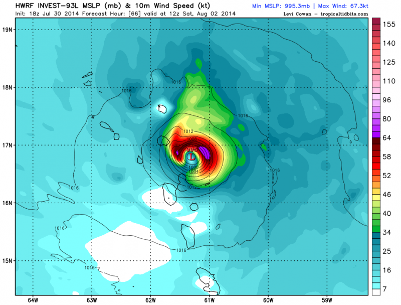
Re: ATL: INVEST 93L - Models
Lol, 18z HWRF brings 93L to a hurricane as it approaches the northern Leeward Islands.
0 likes
-
Blown Away
- S2K Supporter
- Posts: 9867
- Joined: Wed May 26, 2004 6:17 am
Re: ATL: INVEST 93L - Models
The global model re curvature occurs 2-3 degrees farther west from 12z to 18z... Keeps inching west with each run.
0 likes
Hurricane Eye Experience: David 79, Irene 99, Frances 04, Jeanne 04, Wilma 05... EYE COMING MY WAY IN 2024…
Hurricane Brush Experience: Andrew 92, Erin 95, Floyd 99, Matthew 16, Irma 17, Ian 22, Nicole 22…
Hurricane Brush Experience: Andrew 92, Erin 95, Floyd 99, Matthew 16, Irma 17, Ian 22, Nicole 22…
Who is online
Users browsing this forum: No registered users and 12 guests