120 hours stationary. looks like its getting left behind. next frame will show it.
http://instantweathermaps.com/ECMWF-php ... b&hour=120
ATL: DEBBY - Post-Tropical
Moderator: S2k Moderators
-
Aric Dunn
- Category 5

- Posts: 21228
- Age: 41
- Joined: Sun Sep 19, 2004 9:58 pm
- Location: Ready for the Chase.
- Contact:
0 likes
Note: If I make a post that is brief. Please refer back to previous posts for the analysis or reasoning. I do not re-write/qoute what my initial post said each time.
If there is nothing before... then just ask
Space & Atmospheric Physicist, Embry-Riddle Aeronautical University,
I believe the sky is falling...
If there is nothing before... then just ask
Space & Atmospheric Physicist, Embry-Riddle Aeronautical University,
I believe the sky is falling...
-
tolakram
- Admin

- Posts: 19171
- Age: 60
- Joined: Sun Aug 27, 2006 8:23 pm
- Location: Florence, KY (name is Mark)
Re: ATL: INVEST 96L - Models
saved

0 likes
M a r k
- - - - -
Join us in chat: Storm2K Chatroom Invite. Android and IOS apps also available.
The posts in this forum are NOT official forecasts and should not be used as such. Posts are NOT endorsed by any professional institution or STORM2K.org. For official information and forecasts, please refer to NHC and NWS products.
-
South Texas Storms

- Professional-Met

- Posts: 4018
- Joined: Thu Jun 24, 2010 12:28 am
- Location: Houston, TX

Re:
Aric Dunn wrote:120 hours stationary. looks like its getting left behind. next frame will show it.
http://instantweathermaps.com/ECMWF/201 ... mb_120.gif
ala CMC run....that showed it 3 runs in a row....all about timing...
0 likes
-
Aric Dunn
- Category 5
- Posts: 21228
- Age: 41
- Joined: Sun Sep 19, 2004 9:58 pm
- Location: Ready for the Chase.
- Contact:
Re: Re:
ROCK wrote:Aric Dunn wrote:120 hours stationary. looks like its getting left behind. next frame will show it.
http://instantweathermaps.com/ECMWF/201 ... mb_120.gif
ala CMC run....that showed it 3 runs in a row....all about timing...
yeah, its stationary at 120 hours.. at this rate next trough will pick it up.
0 likes
Note: If I make a post that is brief. Please refer back to previous posts for the analysis or reasoning. I do not re-write/qoute what my initial post said each time.
If there is nothing before... then just ask
Space & Atmospheric Physicist, Embry-Riddle Aeronautical University,
I believe the sky is falling...
If there is nothing before... then just ask
Space & Atmospheric Physicist, Embry-Riddle Aeronautical University,
I believe the sky is falling...
-
tolakram
- Admin
- Posts: 19171
- Age: 60
- Joined: Sun Aug 27, 2006 8:23 pm
- Location: Florence, KY (name is Mark)
Re: ATL: INVEST 96L - Models
saved

0 likes
M a r k
- - - - -
Join us in chat: Storm2K Chatroom Invite. Android and IOS apps also available.
The posts in this forum are NOT official forecasts and should not be used as such. Posts are NOT endorsed by any professional institution or STORM2K.org. For official information and forecasts, please refer to NHC and NWS products.
- - - - -
Join us in chat: Storm2K Chatroom Invite. Android and IOS apps also available.
The posts in this forum are NOT official forecasts and should not be used as such. Posts are NOT endorsed by any professional institution or STORM2K.org. For official information and forecasts, please refer to NHC and NWS products.
-
bqhurricane
- Tropical Low

- Posts: 19
- Joined: Wed Sep 21, 2005 2:31 pm
Re: ATL: INVEST 96L - Models
Possibility of hitting NOLA, backing out, then hitting Galveston?
http://moe.met.fsu.edu/cgi-bin/cmctc2.c ... =Animation
http://moe.met.fsu.edu/cgi-bin/cmctc2.c ... =Animation
0 likes
-
northjaxpro

- S2K Supporter

- Posts: 8900
- Joined: Mon Sep 27, 2010 11:21 am
- Location: Jacksonville, FL
Man it is really, really going to be a close call with regards of the trough picking up this system. All a matter of timing.
Could indeed be seeing an Elena '85 type scenario.
Could indeed be seeing an Elena '85 type scenario.
0 likes
NEVER, EVER SAY NEVER in the tropics and weather in general, and most importantly, with life itself!!
________________________________________________________________________________________
Fay 2008 Beryl 2012 Debby 2012 Colin 2016 Hermine 2016 Julia 2016 Matthew 2016 Irma 2017 Dorian 2019
________________________________________________________________________________________
Fay 2008 Beryl 2012 Debby 2012 Colin 2016 Hermine 2016 Julia 2016 Matthew 2016 Irma 2017 Dorian 2019
ATL: INVEST 96L
bqhurricane wrote:Possibility of hitting NOLA, backing out, then hitting Galveston?
http://moe.met.fsu.edu/cgi-bin/cmctc2.c ... =Animation
that is the CMC run from earlier....we are talking about the EURO that is coming out...
0 likes
-
South Texas Storms
- Professional-Met
- Posts: 4018
- Joined: Thu Jun 24, 2010 12:28 am
- Location: Houston, TX
Re: Re:
Aric Dunn wrote:ROCK wrote:Aric Dunn wrote:120 hours stationary. looks like its getting left behind. next frame will show it.
http://instantweathermaps.com/ECMWF/201 ... mb_120.gif
ala CMC run....that showed it 3 runs in a row....all about timing...
yeah, its stationary at 120 hours.. at this rate next trough will pick it up.
No aric, moved slightly west from 96 hrs to 120 hrs.
0 likes
-
cycloneye

- Admin
- Posts: 139329
- Age: 67
- Joined: Thu Oct 10, 2002 10:54 am
- Location: San Juan, Puerto Rico
Re: ATL: INVEST 96L
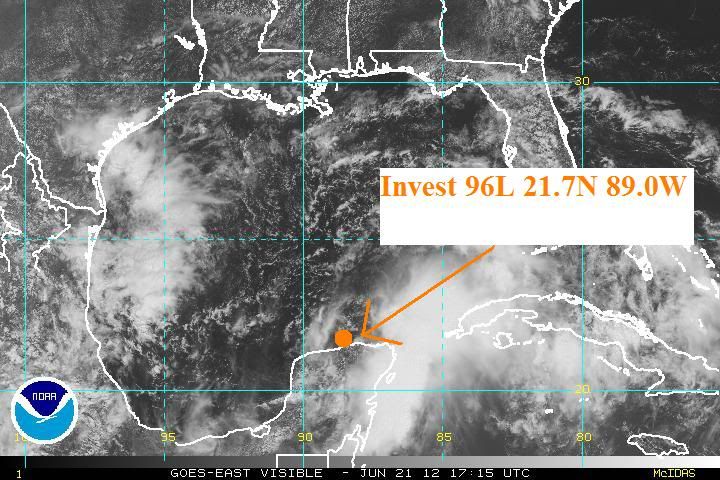
First position of invest 96L.
0 likes
Visit the Caribbean-Central America Weather Thread where you can find at first post web cams,radars
and observations from Caribbean basin members Click Here
and observations from Caribbean basin members Click Here
-
Aric Dunn
- Category 5
- Posts: 21228
- Age: 41
- Joined: Sun Sep 19, 2004 9:58 pm
- Location: Ready for the Chase.
- Contact:
we will call that slight movement and a drift. even stationary system are not technically stationary. in that 24 hours period it barely moved is all i meant.
0 likes
Note: If I make a post that is brief. Please refer back to previous posts for the analysis or reasoning. I do not re-write/qoute what my initial post said each time.
If there is nothing before... then just ask
Space & Atmospheric Physicist, Embry-Riddle Aeronautical University,
I believe the sky is falling...
If there is nothing before... then just ask
Space & Atmospheric Physicist, Embry-Riddle Aeronautical University,
I believe the sky is falling...
-
South Texas Storms
- Professional-Met
- Posts: 4018
- Joined: Thu Jun 24, 2010 12:28 am
- Location: Houston, TX
Re:
Aric Dunn wrote:we will call that slight movement and a drift. even stationary system are not technically stationary. in that 24 hours period it barely moved is all i meant.
Well the next trough is no where in sight...
0 likes
-
tropicwatch
- Category 5
- Posts: 3205
- Age: 60
- Joined: Sat Jun 02, 2007 10:01 am
- Location: Panama City Florida
- Contact:
Re: ATL: INVEST 96L
Upper level winds have died down considerably and it appears high pressure is building above the low.
Deep-layer wind shear
Tropicwatch
Deep-layer wind shear
Tropicwatch
0 likes
-
latitude_20

- Tropical Storm

- Posts: 196
- Joined: Wed Jun 30, 2010 6:46 am
- Location: Tulum, Mexico
- Contact:
-
stormandan28
- Tropical Storm
- Posts: 108
- Joined: Mon Jun 14, 2004 11:13 am
- Contact:

There are synoptic pattern differences in 12z euro vs 0z euro. There is an extension of the ridge going to the southeast in 12z. If this is the case my guess is the rest of the run will go west. 0z had lower pressures in Georgia and Florida.
0 likes
The above post and any post by Ntxw is NOT an official forecast and should not be used as such. It is just the opinion of the poster and may or may not be backed by sound meteorological data. It is NOT endorsed by any professional institution including Storm2k. For official information, please refer to NWS products.
Help support Storm2K!

-
South Texas Storms
- Professional-Met
- Posts: 4018
- Joined: Thu Jun 24, 2010 12:28 am
- Location: Houston, TX
Re: ATL: INVEST 96L - Models
stormandan28 wrote:just north of Tampa at 168 hrs
That's the 0z run. 12z run isn't out to 144 hours yet.
0 likes
-
tolakram
- Admin
- Posts: 19171
- Age: 60
- Joined: Sun Aug 27, 2006 8:23 pm
- Location: Florence, KY (name is Mark)
Re: ATL: INVEST 96L - Models
This is the run page. 144 not done yet for the 12z run.
http://raleighwx.americanwx.com/models/ecmwf.html
http://raleighwx.americanwx.com/models/ecmwf.html
0 likes
M a r k
- - - - -
Join us in chat: Storm2K Chatroom Invite. Android and IOS apps also available.
The posts in this forum are NOT official forecasts and should not be used as such. Posts are NOT endorsed by any professional institution or STORM2K.org. For official information and forecasts, please refer to NHC and NWS products.
- - - - -
Join us in chat: Storm2K Chatroom Invite. Android and IOS apps also available.
The posts in this forum are NOT official forecasts and should not be used as such. Posts are NOT endorsed by any professional institution or STORM2K.org. For official information and forecasts, please refer to NHC and NWS products.
-
Stormcenter
- S2K Supporter
- Posts: 6617
- Joined: Wed Sep 03, 2003 11:27 am
- Location: Houston, TX
Re: Re:
It's June and not Sept. so the likelihood of another trough picking it up is not high. IMO
South Texas Storms wrote:Aric Dunn wrote:we will call that slight movement and a drift. even stationary system are not technically stationary. in that 24 hours period it barely moved is all i meant.
Well the next trough is no where in sight...
0 likes
Who is online
Users browsing this forum: No registered users and 15 guests