I have to agree with JB on this one...........
https://twitter.com/BigJoeBastardi/stat ... 38/photo/1
ATL: CHRIS - Post-Tropical
Moderator: S2k Moderators
-
Dean4Storms
- S2K Supporter

- Posts: 6355
- Age: 61
- Joined: Sun Aug 31, 2003 1:01 pm
- Location: Miramar Bch. FL

Re:
Dean4Storms wrote:I have to agree with JB on this one...........
https://twitter.com/BigJoeBastardi/stat ... 38/photo/1
Them missing that doesn't make Chris any less of a tropical storm. For whatever reason the NHC didn't think it was a TS.
Last edited by Zanthe on Tue Jun 19, 2012 6:50 pm, edited 1 time in total.
0 likes
I'm no expert, everything I say should be taken with a large amount of salt. I could easily be very, very wrong.
~Zanthe Go Coyotes~
~Zanthe Go Coyotes~
-
ozonepete
- Professional-Met

- Posts: 4743
- Joined: Mon Sep 07, 2009 3:23 pm
- Location: From Ozone Park, NYC / Now in Brooklyn, NY
Re:
Dean4Storms wrote:I have to agree with JB on this one...........
https://twitter.com/BigJoeBastardi/stat ... 38/photo/1
If he made that post on here he'd get a warning from the moderators, lol. The NHC has a really hard job and I don't know of anyone who could do better.
0 likes


Re: ATL: CHRIS - Tropical Storm
[list=][/list]
I thought after the season the NHC confirmed it to form earlier at a lower latitude.
Edit: Yes, BT says it transitioned at 39.9 N, which is still a higher latitude than Chris.
ozonepete wrote::uarrow: Yup, Zanthe. Here's the quote from WIKI:
2009 - Tropical Storm Grace formed at 41.2°N latitude by 20.3°W longitude, eclipsing the record set by Hurricane Vince for the farthest northeast forming tropical storm in the Atlantic basin.
I thought after the season the NHC confirmed it to form earlier at a lower latitude.
Edit: Yes, BT says it transitioned at 39.9 N, which is still a higher latitude than Chris.
Last edited by bg1 on Tue Jun 19, 2012 6:49 pm, edited 1 time in total.
0 likes
-
brunota2003

- S2K Supporter
- Posts: 9476
- Age: 33
- Joined: Sat Jul 30, 2005 9:56 pm
- Location: Stanton, KY...formerly Havelock, NC
- Contact:
So the NHC is supposed to name Nor' Easters now because it had a strong pressure fall and high winds? Ummm.......then they have missed a number of storms that meet that definition!
Anyways, remember the Unnamed Hurricane of 1991? The perfect storm, a hurricane formed in the middle of a large low off the U.S. Northeast? The Halloween storm, even had recon fly into it? Yeah, that storm...that is what Chris reminds me of! Just without the sinking fishing vessel, horrible coastal conditions, and recon flying into it. I wish we could get recon on these types of systems, though...so we could figure out just what exactly they really are.
Anyways, remember the Unnamed Hurricane of 1991? The perfect storm, a hurricane formed in the middle of a large low off the U.S. Northeast? The Halloween storm, even had recon fly into it? Yeah, that storm...that is what Chris reminds me of! Just without the sinking fishing vessel, horrible coastal conditions, and recon flying into it. I wish we could get recon on these types of systems, though...so we could figure out just what exactly they really are.
0 likes
Just a small town southern boy helping other humans.
-
ozonepete
- Professional-Met
- Posts: 4743
- Joined: Mon Sep 07, 2009 3:23 pm
- Location: From Ozone Park, NYC / Now in Brooklyn, NY
Re: ATL: CHRIS - Tropical Storm
0 likes
-
ozonepete
- Professional-Met
- Posts: 4743
- Joined: Mon Sep 07, 2009 3:23 pm
- Location: From Ozone Park, NYC / Now in Brooklyn, NY
Re: ATL: CHRIS - Tropical Storm
bg1 wrote:[list=][/list]ozonepete wrote::uarrow: Yup, Zanthe. Here's the quote from WIKI:
2009 - Tropical Storm Grace formed at 41.2°N latitude by 20.3°W longitude, eclipsing the record set by Hurricane Vince for the farthest northeast forming tropical storm in the Atlantic basin.
I thought after the season the NHC confirmed it to form earlier at a lower latitude.
Edit: Yes, BT says it transitioned at 39.9 N, which is still a higher latitude than Chris.
You missed the key-word: farthest northeast, not north.
0 likes
-
AJC3

- Admin

- Posts: 3874
- Age: 60
- Joined: Tue Aug 31, 2004 7:04 pm
- Location: West Melbourne, Florida
- Contact:
Gang, several of these posts are straying from the topic at hand - which is Tropical Storm Chris.
Every season, we have a number of debates about systems that are on the cusp of TD versus TS, TS versus hurricane, closed wind circulation versus open wave, XTC versus STC versus TC, etc. etc.
A couple things to keep in mind: As we have seen so many times over the years, there really isn't a "black and white" when it comes to these delineations. There is a spectrum of cyclone types, and often times we have systems that have their feet in more than one area of the spectrum at different times.
Also, the NHC isn't a one-headed monster. While an agency can and should strive for consistency, different forecasters will interpret different data sets in their own unique manner.
Given that there is quite a bit of subjectivity when it comes to determining cyclone type, strength, etc. and that you have several different forecasters who are making these determinations, invariably there will be some consistency issues that crop up.
It's easy to disagree with NHC. But keep an open mind, be factual and respectful, not emotional, and consider the points I brought up.
0 likes
-
ozonepete
- Professional-Met
- Posts: 4743
- Joined: Mon Sep 07, 2009 3:23 pm
- Location: From Ozone Park, NYC / Now in Brooklyn, NY
Re: ATL: CHRIS - Tropical Storm
0 likes
-
brunota2003
- S2K Supporter
- Posts: 9476
- Age: 33
- Joined: Sat Jul 30, 2005 9:56 pm
- Location: Stanton, KY...formerly Havelock, NC
- Contact:
-
cycloneye

- Admin
- Posts: 139327
- Age: 67
- Joined: Thu Oct 10, 2002 10:54 am
- Location: San Juan, Puerto Rico
Re: ATL: CHRIS - Tropical Storm
00z Best Track.
AL, 03, 2012062000, , BEST, 0, 389N, 568W, 40, 1005, TS
http://ftp.nhc.noaa.gov/atcf/tcweb/inve ... 012.invest
AL, 03, 2012062000, , BEST, 0, 389N, 568W, 40, 1005, TS
http://ftp.nhc.noaa.gov/atcf/tcweb/inve ... 012.invest
0 likes
Visit the Caribbean-Central America Weather Thread where you can find at first post web cams,radars
and observations from Caribbean basin members Click Here
and observations from Caribbean basin members Click Here


Re: ATL: CHRIS - Tropical Storm
finally this guy was named....I have been preaching to the chat room about this guy all week. Name it all ready so I can meet my 13/9/4 numbers.... 
personally I think it should have been named a long time ago but no sense in beating dead horse.
personally I think it should have been named a long time ago but no sense in beating dead horse.
0 likes


-
brunota2003
- S2K Supporter
- Posts: 9476
- Age: 33
- Joined: Sat Jul 30, 2005 9:56 pm
- Location: Stanton, KY...formerly Havelock, NC
- Contact:
Well...SHPS/DSHPS did show Chris peaking out at 58 knotsin today's 18Z runs...but that was like 72 hours from now
Raw ADT numbers are 2.9 right now...or about 43 knots (2.8 is 41 knots, 3.0 is 45 knots). Not much change from earlier.
DATE TIME LAT LON CLASSIFICATION ID NAME
20120619 2345 38.8 56.7 T2.5/2.5 03L CHRIS
20120619 1745 39.4 58.0 T2.0/2.0 95L 95L
T#s are up to 2.5 now.
Raw ADT numbers are 2.9 right now...or about 43 knots (2.8 is 41 knots, 3.0 is 45 knots). Not much change from earlier.
DATE TIME LAT LON CLASSIFICATION ID NAME
20120619 2345 38.8 56.7 T2.5/2.5 03L CHRIS
20120619 1745 39.4 58.0 T2.0/2.0 95L 95L
T#s are up to 2.5 now.
0 likes
Just a small town southern boy helping other humans.
-
cycloneye
- Admin
- Posts: 139327
- Age: 67
- Joined: Thu Oct 10, 2002 10:54 am
- Location: San Juan, Puerto Rico
Re: ATL: CHRIS - Tropical Storm
WTNT43 KNHC 200247
TCDAT3
TROPICAL STORM CHRIS DISCUSSION NUMBER 2
NWS NATIONAL HURRICANE CENTER MIAMI FL AL032012
1100 PM AST TUE JUN 19 2012
CHRIS IS PRODUCING A CURLED...COMPACT AREA OF DEEP CONVECTION THAT
IS DISPLACED JUST TO THE EAST AND SOUTHEAST OF THE LOW-LEVEL
CENTER. TAFB AND SAB PROVIDED DVORAK ESTIMATES OF 35 KT...AND THE
LATEST UW-CIMSS ADT IS ABOUT 40 KT. SINCE THE OVERALL ORGANIZATION
HAS CHANGED LITTLE SINCE THIS AFTERNOON...THE INTENSITY WILL BE
HELD AT 40 KT.
CHRIS IS EMBEDDED WITHIN A DIGGING MID- TO UPPER-LEVEL TROUGH...SO
IT IS NOW MOVING TOWARD THE EAST-SOUTHEAST AT A FASTER SPEED...OR
110/11 KT. A CLOSED LOW IS FORECAST TO DEVELOP AT THE NORTHERN END
OF THE TROUGH OVER THE NEXT 24 TO 48 HOURS...WHICH WILL ENHANCE THE
MID-LATITUDE WESTERLY FLOW AND CAUSE CHRIS TO FURTHER ACCELERATE
TOWARD THE EAST AND EAST-NORTHEAST THROUGH EARLY THURSDAY. AFTER
THE LOW CLOSES OFF AND STALLS...CHRIS WILL BEGIN TO LOOP
CYCLONICALLY AROUND THE LOW BY 48 AND 72 HOURS. THE TRACK MODELS
ALL AGREE ON THIS SCENARIO. THE GFS AND ECMWF LIE ON THE WESTERN
SIDE OF THE ENVELOPE WHILE THE GFDL AND HWRF LIE ON THE EASTERN
SIDE. GIVEN THE MID-LATITUDE ENVIRONMENT...THE NHC FORECAST LEANS
MORE HEAVILY TOWARD THE GLOBAL MODEL SOLUTIONS. DISSIPATION IS
FORECAST BY 96 HOURS WHEN CHRIS SHOULD BE FULLY ABSORBED WITHIN THE
CLOSED LOW.
THE GLOBAL MODEL GUIDANCE DOES NOT PROVIDE A CLEAR-CUT ANSWER OF
WHEN EXTRATROPICAL TRANSITION WILL END. THE FSU PHASE-SPACE
DIAGRAMS BASED OFF THE GFS SUGGEST THAT THE THERMAL STRUCTURE WILL
BECOME INCREASINGLY ASYMMETRIC WITH A SHALLOWER WARM CORE DURING
THE NEXT 24 HOURS. THEREAFTER...THE DIAGRAMS INDICATE THAT CHRIS
WILL AGAIN DEVELOP A DEEPER WARM CORE...BUT THIS MOST LIKELY IS
REPRESENTATIVE OF AN EXTRATROPICAL WARM SECLUSION. ON THIS
BASIS...CHRIS IS FORECAST TO BE FULLY EXTRATROPICAL BY 36 HOURS.
DUE TO RELATIVELY COOL SEA SURFACE TEMPERATURES AND MODERATE
VERTICAL SHEAR...CHRIS IS EXPECTED TO CHANGE LITTLE IN STRENGTH
UNTIL IT BECOMES EXTRATROPICAL AND FEEDS OFF BAROCLINIC ENERGY
ASSOCIATED WITH THE CLOSED MID/UPPER-LEVEL LOW.
FORECAST POSITIONS AND MAX WINDS
INIT 20/0300Z 38.8N 56.0W 40 KT 45 MPH
12H 20/1200Z 38.7N 52.9W 40 KT 45 MPH
24H 21/0000Z 39.5N 48.4W 40 KT 45 MPH
36H 21/1200Z 41.4N 44.7W 45 KT 50 MPH...POST-TROP/EXTRATROP
48H 22/0000Z 43.7N 43.8W 45 KT 50 MPH...POST-TROP/EXTRATROP
72H 23/0000Z 44.5N 45.5W 35 KT 40 MPH...POST-TROP/EXTRATROP
96H 24/0000Z...ABSORBED BY ANOTHER EXTRATROPICAL LOW
$$
FORECASTER BERG
0 likes
Visit the Caribbean-Central America Weather Thread where you can find at first post web cams,radars
and observations from Caribbean basin members Click Here
and observations from Caribbean basin members Click Here
-
ozonepete
- Professional-Met
- Posts: 4743
- Joined: Mon Sep 07, 2009 3:23 pm
- Location: From Ozone Park, NYC / Now in Brooklyn, NY
Re: ATL: CHRIS - Tropical Storm
Ok, so I wasn't deluded. It has been moving southeastward, or at least it was not moving due east.
0 likes
-
brunota2003
- S2K Supporter
- Posts: 9476
- Age: 33
- Joined: Sat Jul 30, 2005 9:56 pm
- Location: Stanton, KY...formerly Havelock, NC
- Contact:
ADT raw T# is now up to 3.4 (about 53 knots)...if the raw stays up there, it'll pull up the 3hr average and final T#s, and we might see a stronger Chris for the 06Z BT.
I personally do not think Chris has 55 knot winds (and convection is starting to weaken a little), but I could see them potentially bumping the winds up to 45 knots if the convection holds and the T#s go up. I also think they'll bring the pressure down to 1003 millibars or so.
I personally do not think Chris has 55 knot winds (and convection is starting to weaken a little), but I could see them potentially bumping the winds up to 45 knots if the convection holds and the T#s go up. I also think they'll bring the pressure down to 1003 millibars or so.
0 likes
Just a small town southern boy helping other humans.
-
ozonepete
- Professional-Met
- Posts: 4743
- Joined: Mon Sep 07, 2009 3:23 pm
- Location: From Ozone Park, NYC / Now in Brooklyn, NY
Re: ATL: CHRIS - Tropical Storm
Latest IR. Not bad at all... This is the kind of satellite presentation that usually bumps the numbers up, as you said may happen. 
Symmetry has helped Chris all along so far. A nice, smooth, circular flow around the center tells us that the winds are not having trouble curling in towads the center, i.e. they can achieve max velocity for that particular configuration: a small, but well developed center with moderately high thunderstorms circling around it.
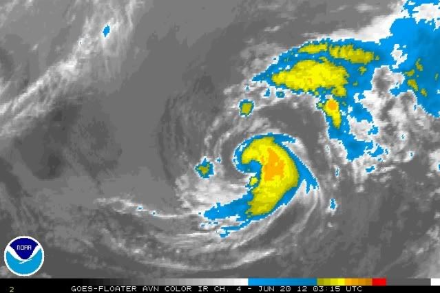
Symmetry has helped Chris all along so far. A nice, smooth, circular flow around the center tells us that the winds are not having trouble curling in towads the center, i.e. they can achieve max velocity for that particular configuration: a small, but well developed center with moderately high thunderstorms circling around it.
0 likes

Re: ATL: CHRIS - Tropical Storm
Chris is a little cool cyclone, I really like its structure. I agree, if convection and organization persist they could go 45 kt in the next advisory.
0 likes

Re: ATL: CHRIS - Tropical Storm
I like being able to track a fish in the ATL.
0 likes
NOTICE: I cannot give an expert analysis. Most of my "observations" are made visually with the help of only vital information provided by public advisories.
Who is online
Users browsing this forum: No registered users and 6 guests