Up to T3.0.
TXMM21 KNES 080021
TCSMED
A. 01M (NONAME)
B. 08/0000Z
C. 41.4N
D. 5.4E
E. THREE/MET-9
F. T3.0/3.0/D2.5/24HRS
G. IR/EIR/SWIR/SSMIS
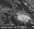
H. REMARKS...1930Z SSMIS PASS SUGGESTS AN EYE-LIKE FEATURE TO BE
PRESENT. GT 6/10 BANDING ON LOG10 SPIRAL YIELDS A DT OF 3.0. MET =
2.5 AND PT = 3.0. FT IS BASED ON DT.
I. ADDL POSITIONS
07/1930Z 41.1N 5.5E SSMIS
...GUILLOT
MED: 01M/ROLF - Tropical Storm
Moderator: S2k Moderators
-
DanieleItalyRm
- Category 1

- Posts: 486
- Age: 38
- Joined: Mon Sep 22, 2008 7:52 am
- Location: Rome - Italy - Mediterranean sea
Re:
Crostorm wrote:
Here is Ascat image,from two i made one image
http://manati.orbit.nesdis.noaa.gov/dat ... ATData.php

probably this is wind in the morning but not in the evening.
HenkL wrote:Dutch ship ("Rotterdam", call-sign PDGS) reporting at 21Z:
wind 38 kt sustained from SSE (160°), pressure 1005.0 hPa
position: 41°36'N 06°06'E
Lyon buoy (61002): 33 kt sustained from NE
position: 42°06'N 04°42'E
Station Cape Cepet (French SE coast): 27 kt sustained from NE, gust 47 kt
Now we have surface observations confirming storm winds
senorpepr wrote:
Surface plots from 21Z, including that 38 kt report from the "Rotterdam"...

As I thought, 40 kts tropcial storm.
Please link for this map?
Last edited by DanieleItalyRm on Mon Nov 07, 2011 8:28 pm, edited 2 times in total.
0 likes


-
Cryomaniac
- Category 5

- Posts: 1289
- Joined: Tue Aug 15, 2006 2:26 pm
- Location: Newark, Nottinghamshire, UK
- Contact:
Re: Re:
bg1 wrote:TheEuropean wrote:No word in TWO, why not? Where would NHC put this on their map?
They probably couldn't track this if they wanted because their software cannot process longitudes east of the meridian.
That seems foolish, although I suppose it's not something the coders would have considered when writing the software.
Anyway, this is a very interesting system, even if the NHC can't officially do anything about it.
0 likes
-
AJC3

- Admin

- Posts: 3873
- Age: 60
- Joined: Tue Aug 31, 2004 7:04 pm
- Location: West Melbourne, Florida
- Contact:
Re: Re:
Cryomaniac wrote:bg1 wrote:TheEuropean wrote:No word in TWO, why not? Where would NHC put this on their map?
They probably couldn't track this if they wanted because their software cannot process longitudes east of the meridian.
That seems foolish, although I suppose it's not something the coders would have considered when writing the software.
Anyway, this is a very interesting system, even if the NHC can't officially do anything about it.
No, it's not foolish at all when you consider their AOR.
0 likes
-
Cryomaniac
- Category 5
- Posts: 1289
- Joined: Tue Aug 15, 2006 2:26 pm
- Location: Newark, Nottinghamshire, UK
- Contact:
Re: Re:
AJC3 wrote:Cryomaniac wrote:bg1 wrote:That seems foolish, although I suppose it's not something the coders would have considered when writing the software.
Anyway, this is a very interesting system, even if the NHC can't officially do anything about it.
No, it's not foolish at all when you consider their AOR.
True, but from a programming point of view it seems silly to me that you would write software that only worked west of Greenwich. I can see why it would be done, but I don't necessarily think it should have been.
0 likes


Re: Mediterranean Sea: 01M NONAME
Where's the O1M.NONAME coming from? NRL doesn't have it up.
0 likes
-
Crostorm

- Category 5
- Posts: 2060
- Age: 49
- Joined: Mon Dec 25, 2006 3:51 pm
- Location: Croatia-Europe
- Contact:
This is first time,that Estofex is using a bulletin
****** Tropical storm 01M ******
SUMMARY: 8th NOV. 2011, 0000 UTC
-----------------------------------------------------------
LOCATION...41.4N 5.4E
ABOUT 111 MI...178 KM S OF MARSEILLE
ABOUT 162 MI...260 KM W OF AJACCIO, CORSICA
MAXIMUM SUSTAINED WINDS...52 MPH...83 KM/H
PRESENT MOVEMENT...ROUGHLY QUASI-STATIONARY
MINIMUM CENTRAL PRESSURE... ROUGHLY 1000 hPa
NOTE 1: Despite issuing new ESTOFEX updates, this part of the outlook will be updated when new informations become available. Please check this table for further updates during the upcoming 24 hours.
NOTE 2: ESTOFEX is not responsible for forecasting any tropical storm activity. This is just an additional information and therefore captured as a "side-note". For more informations, please contact the following address of the Satellite Analysis Branch (http://www.ssd.noaa.gov/PS/TROP/2011/bu ... chive.html,[SAB]).
http://www.estofex.org/cgi-bin/polygon/ ... recast.xml
0 likes
-
phwxenthusiast
- Category 2

- Posts: 637
- Joined: Wed Mar 24, 2010 3:10 am
- Location: Holbrook, NY (Long Island)
Re: Mediterranean Sea: 01M NONAME
Cranica wrote:Where's the O1M.NONAME coming from? NRL doesn't have it up.
it's 99L under the Atlantic Section on the NRL Page... then again, as others have pointed out, doesn't mean it's under NHC's jursidiction...
0 likes
-
P.K.

- Professional-Met

- Posts: 5149
- Joined: Thu Sep 23, 2004 5:57 pm
- Location: Watford, England
- Contact:
Re: Mediterranean Sea: 01M NONAME
TXMM21 KNES 080630
TCSMED
A. 01M (NONAME)
B. 08/0600Z
C. 41.5N
D. 5.8E
E. THREE/MET-9
F. T3.0/3.0/D1.5/24HRS
G. IR/EIR/SWIR
H. REMARKS...CONVECTION WRAPS ALMOST .7 ON LOG10 SPIRAL YIELDING A DT
OF 3.0. MET = 2.5 AND PT = 3.0. FT IS BASED ON DT.
I. ADDL POSITIONS
NIL
...KIBLER
TCSMED
A. 01M (NONAME)
B. 08/0600Z
C. 41.5N
D. 5.8E
E. THREE/MET-9
F. T3.0/3.0/D1.5/24HRS
G. IR/EIR/SWIR
H. REMARKS...CONVECTION WRAPS ALMOST .7 ON LOG10 SPIRAL YIELDING A DT
OF 3.0. MET = 2.5 AND PT = 3.0. FT IS BASED ON DT.
I. ADDL POSITIONS
NIL
...KIBLER
0 likes
Re: Mediterranean Sea: 01M NONAME
ROUGHLY QUASI-STATIONARY
I laughed. Is this translation weirdness or something?
0 likes
-
DanieleItalyRm
- Category 1
- Posts: 486
- Age: 38
- Joined: Mon Sep 22, 2008 7:52 am
- Location: Rome - Italy - Mediterranean sea
Re: Mediterranean Sea: 01M NONAME
the boa of Alghero (Sardinia) misure 4-5 metres wave. The maximum wave misure 6 metres.
TWenty-foot waves are not caused by 15 kts wind, this 40-45 kts tropical storm.


Uploaded with ImageShack.us
The special characteristics of the mediterranean tropical cyclones make their detection difficult: only with
high resolution meteorological analysis data and dense maritime observations that task
would be possible. An alternative method, using satellite data and restricted criteria
about the disturbance symmetry, size and lifespan, has been successfully used to detect
twelve mediterranean tropical system from 1982 to 2003.(Meteorological environments associated with medicane
development).
Last edited by DanieleItalyRm on Tue Nov 08, 2011 5:38 am, edited 1 time in total.
0 likes

Again from ESTOFEX
A side-note:
****** Tropical storm 01M/99L ******
SUMMARY: 8th NOV. 2011, 0600 UTC
-----------------------------------------------------------
LOCATION...41.5N 5.8E
ABOUT 108 NM...200 KM SE OF MARSEILLE
ABOUT 126 NM...233 KM W OF AJACCIO, CORSICA
MAXIMUM SUSTAINED WINDS...52 MPH...83 KM/H
PRESENT MOVEMENT...ROUGHLY 5KM/H TO THE EAST
MINIMUM CENTRAL PRESSURE... ROUGHLY 1000 hPa
UPDATE 06UTC: The center of the cyclone again became better organized with the strongest convection now in the southern and eastern part (maybe enhanced by the jet streak, which passes by to the SE). Some slow movement to the east occurred but despite a further consolidating cyclone, latest reports do not indicate any strengthening (also assisted by ASCAT data). No further surface reports were available.
NOTE 1: Despite issuing new ESTOFEX updates, this part of the outlook will be updated when new informations become available. Please check this table for further updates during the upcoming 24 hours.
NOTE 2: ESTOFEX is not responsible for forecasting any tropical storm activity. This is just an additional information and therefore captured as a "side-note". For more informations, please contact the following address of the Satellite Analysis Branch (http://www.ssd.noaa.gov/PS/TROP/2011/bu ... chive.html,[SAB]).
As of 18 UTC (7th Nov.), the Satellite Analysis Branch upgraded the depression over the W-Mediterranean to "Tropical system 01M", as convection persisted for an adequate time atop the center. Since then, deep convection weakened somewhat with warming cloud tops next to the center. Nevertheless, very good banding is now present in all quadrants with good outflow atop (especially to the NE, pointing to a 30 m/s 300 hPa jet). A Dvorak number-pressure relation was used for the pressure classification (also at 21Z at the 7th, a ship at position N 41°36' , E 6°06' reported a pressure of 1005.0 mb with 38kt winds from 160°). The final wind strength reflects the intensity of the latest SAB guidance.
There remains some time left for further intensification, before geopotential heights slowly increase during the end of the forecast period. We would not be surprised to see another flare-up of DMC along the center due to the convective cycle of those features (peaking during the morning hours). The N-outflow may weaken somewhat as the upper jet to the north weakens, but at the same time the southern outflow channel could take profit of a 300 hPa streak, which crosses Sicily during the forecast from SW to NE. SSTs remain at or above 20°C, whereas 500 hPa temperatures gradually warm up 1-2K until 06Z. Combining all those effects, some further organization/strengthening is forecast if this system can support more convective bursts along the center before overall conditions become somewhat less favorable during the night hours onwards.
The storm motion is handeled badly by the models...without surprise. 01M is captured in a very weak steering flow and most models now show a system, which meanders around between the Balearic Islands and Corsica/Sardinia. In any case, residents along the adjacent coasts should keep a close eye on the further development of this feature as bands of strong convection may bring heavy downpours next to gusty winds.
0 likes
The following post is NOT an official forecast and should not be used as such. It is just the opinion of the poster and may or may not be backed by sound meteorological data. It is NOT endorsed by any professional institution including storm2k.org For Official Information please refer to the NHC and NWS products.
-
DanieleItalyRm
- Category 1
- Posts: 486
- Age: 38
- Joined: Mon Sep 22, 2008 7:52 am
- Location: Rome - Italy - Mediterranean sea


-
DanieleItalyRm
- Category 1
- Posts: 486
- Age: 38
- Joined: Mon Sep 22, 2008 7:52 am
- Location: Rome - Italy - Mediterranean sea
ESTOFEX:
****** Tropical storm 01M/99L ******
SUMMARY: 8th NOV. 2011, 0600 UTC
-----------------------------------------------------------
LOCATION...41.5N 5.8E
ABOUT 108 NM...200 KM SE OF MARSEILLE
ABOUT 126 NM...233 KM W OF AJACCIO, CORSICA
MAXIMUM SUSTAINED WINDS...52 MPH...83 KM/H
PRESENT MOVEMENT...ROUGHLY 5KM/H TO THE EAST
MINIMUM CENTRAL PRESSURE... ROUGHLY 1000 hPa
Last edited by DanieleItalyRm on Tue Nov 08, 2011 8:24 am, edited 2 times in total.
0 likes
-
P.K.
- Professional-Met
- Posts: 5149
- Joined: Thu Sep 23, 2004 5:57 pm
- Location: Watford, England
- Contact:
Re: Mediterranean Sea: 01M NONAME
TXMM21 KNES 081225
TCSMED
A. 01M (NONAME)
B. 08/1200Z
C. 42.1N
D. 6.2E
E. THREE/MET-9
F. T2.5/3.0/W0.5/12HRS
G. IR/EIR/VIS
H. REMARKS...CONVECTION HAS DECREASED OVER THE LAST 6...AND ESPECIALLY
12 HOURS. CIRCULATION IS LARGELY EXPOSED EXCEPT FOR SHALLOW CONVECTION
TO THE NORTHEAST OF THE CENTER OF CIRCULATION THAT MEASURES 3/10 ON
LOG10 SPIRAL. DT IS 2.0. MET AND PT ARE UNDEFINED BECAUSE SYSTEM WAS
NOT TROPICAL 24 HOURS AGO. FT IS BASED ON TRADITIONAL DVORAK CONSTRAINTS
LIMITING CHANGES IN FT TO 1/2 T NUMBER OVER 6 HOURS.
I. ADDL POSITIONS
NIL
...TURK
0 likes
-
DanieleItalyRm
- Category 1
- Posts: 486
- Age: 38
- Joined: Mon Sep 22, 2008 7:52 am
- Location: Rome - Italy - Mediterranean sea
Lamma model confirm 35-45 kts - gust 45-55 kts.
In this moment moved over cold sea..

Uploaded with ImageShack.us
In this moment moved over cold sea..

Uploaded with ImageShack.us
0 likes

Very cool.  How often do systems occur in the Med?
0 likes
Andrew '92 Opal '95 Blizzard '96 Izzy '03 Irene '11 Sandy '12
The following post is NOT an official forecast and should not be used as such. It is just the opinion is not be backed by sound meteorological data. It is NOT endorsed by any professional institution including storm2k.org For Official Information please refer to the NHC and NWS products.
The following post is NOT an official forecast and should not be used as such. It is just the opinion is not be backed by sound meteorological data. It is NOT endorsed by any professional institution including storm2k.org For Official Information please refer to the NHC and NWS products.
12z update from ESTOFEX. They have it a little weaker.
LOCATION...42.1N 6.2E
ABOUT 84 NM...156 KM SE OF MARSEILLE
ABOUT 114 NM...210 KM W OF AJACCIO, CORSICA
MAXIMUM SUSTAINED WINDS...46 MPH...74 KM/H
PRESENT MOVEMENT...ROUGHLY 10KM/H TO THE EASTNORTHEAST
MINIMUM CENTRAL PRESSURE... BETWEEN 1000-1005 hPa
UPDATE 12UTC: The new update of SAB now indicates some weakening, as deep convection failed to re-develop mainly in the western part. WV imagery also indicates some dry air intrusion from higher levels, which gradually raises concern about how pronounced the warm core structure is right now. However, intense DMC evolved in the last hour or so mainly in the eastern/northern part and starts to wrap around the center. UW CIMMS also hints on somewhat augmented shear, which should remain steady during the next few hours. The cyclone now starts to increase its forward speed and moves more to the ENE to NE. This may be the result of an upper wave, which passes by to the west. Models want to stall this feature just SW of Liguria as the upper waves moves off to the north later tonight. The risk for strong downpours and gusty winds may increases over far SE France and probably along the W-Ligurian coast during the following hours.
0 likes
The following post is NOT an official forecast and should not be used as such. It is just the opinion of the poster and may or may not be backed by sound meteorological data. It is NOT endorsed by any professional institution including storm2k.org For Official Information please refer to the NHC and NWS products.
Who is online
Users browsing this forum: No registered users and 19 guests