
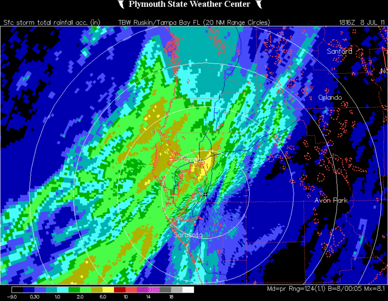
RADAR estimated rainfall amounts now 4-6 inches in central and northern Pinellas County. We may see some flooding with the training of cells over the same area for the next 6 hrs.
TPA RADAR
ATL: INVEST 96L - Discussion
Moderator: S2k Moderators
Re: ATL: INVEST 96L - Discussion
0 likes


Re: ATL: INVEST 96L - Discussion
Sanibel wrote:ULL-enhanced convection off a weak, squashed Low.
Is not just the ULL, if you look at vis sat along with surface reports there is a good surface convergence going on along the surface trough, otherwise that convection along the Tampa area would had died off a while ago.
0 likes
-
cycloneye

- Admin

- Posts: 139206
- Age: 67
- Joined: Thu Oct 10, 2002 10:54 am
- Location: San Juan, Puerto Rico
Re: ATL: INVEST 96L - Discussion

TROPICAL WEATHER OUTLOOK
NWS NATIONAL HURRICANE CENTER MIAMI FL
200 PM EDT FRI JUL 8 2011
FOR THE NORTH ATLANTIC...CARIBBEAN SEA AND THE GULF OF MEXICO...
AN ELONGATED AREA OF LOW PRESSURE EXTENDING FROM THE EASTERN GULF OF
MEXICO NORTHEASTWARD ACROSS NORTHERN FLORIDA IS PRODUCING
DISORGANIZED CLOUDINESS AND SHOWERS PRIMARILY OVER FLORIDA AND THE
ADJACENT WATERS. THIS ACTIVITY IS GRADUALLY SPREADING NORTHWARD.
ENVIRONMENTAL CONDITIONS ARE NOT FAVORABLE FOR DEVELOPMENT AND
THERE IS A LOW CHANCE...NEAR 0 PERCENT...OF THIS SYSTEM BECOMING A
TROPICAL OR SUBTROPICAL CYCLONE DURING THE NEXT 48 HOURS.
ELSEWHERE...TROPICAL CYCLONE FORMATION IS NOT EXPECTED DURING THE
NEXT 48 HOURS.
$$
FORECASTER AVILA
0 likes
Visit the Caribbean-Central America Weather Thread where you can find at first post web cams,radars
and observations from Caribbean basin members Click Here
and observations from Caribbean basin members Click Here

-
thetruesms

- Professional-Met

- Posts: 844
- Age: 40
- Joined: Thu Aug 16, 2007 1:14 pm
- Location: Tallahasee, FL
- Contact:
Re:
Sort of. West Central Florida is the one part of the state that didn't really need the rain all that much - at least relative to the rest of the state. The Panhandle is what really needs a good drenching right now.plasticup wrote:At least FL is getting some of that rain they've needed.
0 likes
-
thetruesms
- Professional-Met
- Posts: 844
- Age: 40
- Joined: Thu Aug 16, 2007 1:14 pm
- Location: Tallahasee, FL
- Contact:
Re: Re:
Yeah, it's probably drawing a little far OT for this thread, but if you want to know more, you can go to http://www.fl-dof.com/fire_weather/info ... /kbdi.html or just PM me, and I can probably make your eyes bleed with infofci wrote:psyclone wrote:it's the keech byram (sp) drought index, a good measure of wildfire potential.
Sorry if this is too off topic; but what are the metrics on the map.
Higher number=More severe drought?
Colors??
0 likes

Re: ATL: INVEST 96L - Discussion
Looks like an anticyclone is forming over this.
Also, strong moisture convergence along the surface trough.


Also, strong moisture convergence along the surface trough.
0 likes
-
tropicwatch
- Category 5

- Posts: 3205
- Age: 60
- Joined: Sat Jun 02, 2007 10:01 am
- Location: Panama City Florida
- Contact:
Re: ATL: Ex INVEST 96L - Discussion
Right now it doesn't look like the remnants of 96 plan to go anywhere very fast. There is an incredible amount of moisture come up into the Gulf, in between the High that building over Florida and the ULL South of Louisiana.
Tropicwatch
Tropicwatch
0 likes
-
ocala
- Tropical Depression

- Posts: 88
- Joined: Sat Apr 08, 2006 8:48 am
- Location: Candler,Florida
- Contact:
Re: ATL: Ex INVEST 96L - Discussion
Heavy rain is very localized. Including yesterday not even .75 at my location in the Ocala area.
0 likes
Re: ATL: Ex INVEST 96L - Discussion
Some of the models are showing the remnants of 96L closing up near Bermuda, possibly as a sub-tropical storm. The convection is definitely there already...
0 likes
Eyes: Emily '86, Dean '89, Felix '95, Gert '99, Fabian '03, Humberto '19, Paulette '20
-
caneman
Re: ATL: Ex INVEST 96L - Discussion
NDG,
I know - we're hear on Clearwater Beach. Made the mistake of leaving my Canoe right side up and it is full of water. Pool was overflowing. Just had a deluge like this last week or two ago.
I know - we're hear on Clearwater Beach. Made the mistake of leaving my Canoe right side up and it is full of water. Pool was overflowing. Just had a deluge like this last week or two ago.
0 likes
-
Tampa Bay Hurricane

- Category 5
- Posts: 5594
- Age: 36
- Joined: Fri Jul 22, 2005 7:54 pm
- Location: St. Petersburg, FL
Re: ATL: Ex INVEST 96L - Discussion
Had a lot of heavy rain some of the nastiest street flooding I've seen today. The rain has ended but it is quite windy, winds have picked up
0 likes
-
Florida1118
- Category 5
- Posts: 1805
- Age: 27
- Joined: Sat Jun 19, 2010 12:57 pm
- Location: Tampa, Florida
Re: ATL: Ex INVEST 96L - Discussion
I got 5.66 Inches of rain today, my backyard is a lovely lake now (its not supposed to be). All of the ponds/lakes near me are at their banks...sorry to the panhandle, hope you get something out of this. We didnt really need it here in WC FLorida...
0 likes

Re: ATL: Ex INVEST 96L - Discussion
0 likes
-
JonathanBelles
- Professional-Met
- Posts: 11430
- Age: 33
- Joined: Sat Dec 24, 2005 9:00 pm
- Location: School: Florida State University (Tallahassee, FL) Home: St. Petersburg, Florida
- Contact:
Who is online
Users browsing this forum: No registered users and 55 guests