ATL: INVEST 96L - Discussion
Moderator: S2k Moderators

Well back down to 30%, I suspect this one isn't going to develop now given what it looks like.
0 likes
Personal Forecast Disclaimer:
The posts in this forum are NOT official forecast and should not be used as such. They are just the opinion of the poster and may or may not be backed by sound meteorological data. They are NOT endorsed by any professional institution or storm2k.org. For official information, please refer to the NHC and NWS products
The posts in this forum are NOT official forecast and should not be used as such. They are just the opinion of the poster and may or may not be backed by sound meteorological data. They are NOT endorsed by any professional institution or storm2k.org. For official information, please refer to the NHC and NWS products

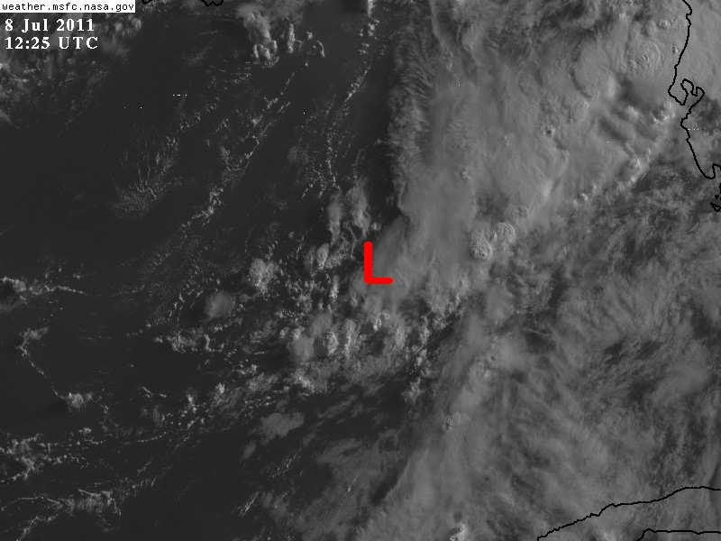
The weak low level circulation that 96L had yesterday is much harder to find this morning, it looks it has opened up to a trough once again, at least for now.
If there is still one, is located near 25.N & 86.5W.
BTW, pressures have continued to lower in the GOM, true that it is through out most of the gulf, but lowest pressure are still in the vicinity of the low pressure center or trough.
If there is still one, is located near 25.N & 86.5W.
BTW, pressures have continued to lower in the GOM, true that it is through out most of the gulf, but lowest pressure are still in the vicinity of the low pressure center or trough.
0 likes

Re: ATL: INVEST 96L - Discussion
Temperature profile reveals that this is most likely becoming a hybrid / sub-tropical system.
850mb vorticity has become less organized since yesterday.
No deep convection near the LLC during DMAX.


850mb vorticity has become less organized since yesterday.
No deep convection near the LLC during DMAX.
0 likes
-
tolakram
- Admin

- Posts: 19167
- Age: 60
- Joined: Sun Aug 27, 2006 8:23 pm
- Location: Florence, KY (name is Mark)
Re: ATL: INVEST 96L - Discussion
Shear has really dropped off since yesterday.

Something to keep an eye on IMO, might be why they went with 40% then down to 30% when convection died.
Something to keep an eye on IMO, might be why they went with 40% then down to 30% when convection died.
0 likes
M a r k
- - - - -
Join us in chat: Storm2K Chatroom Invite. Android and IOS apps also available.
The posts in this forum are NOT official forecasts and should not be used as such. Posts are NOT endorsed by any professional institution or STORM2K.org. For official information and forecasts, please refer to NHC and NWS products.
Chances back down to 10% and I agree, it has become an elongated trough of low pressure, may not have the closed low that it had yesterday morning.
ZCZC MIATWOAT ALL
TTAA00 KNHC DDHHMM
TROPICAL WEATHER OUTLOOK
NWS NATIONAL HURRICANE CENTER MIAMI FL
800 AM EDT FRI JUL 8 2011
FOR THE NORTH ATLANTIC...CARIBBEAN SEA AND THE GULF OF MEXICO...
1. AN ELONGATED AREA OF LOW PRESSURE IS PRODUCING DISORGANIZED
CLOUDINESS AND SHOWERS PRIMARILY OVER FLORIDA AND THE ADJACENT
WATERS. ENVIRONMENTAL CONDITIONS HAVE BECOME LESS CONDUCIVE AND THE
POTENTIAL FOR DEVELOPMENT HAS DIMINISHED. THERE IS A LOW
CHANCE...10 PERCENT...OF THIS SYSTEM BECOMING A TROPICAL OR
SUBTROPICAL CYCLONE DURING THE NEXT 48 HOURS AS IT MOVES NORTHWARD
OR NORTH-NORTHEASTWARD.
0 likes
-
wxman57

- Moderator-Pro Met

- Posts: 22482
- Age: 66
- Joined: Sat Jun 21, 2003 8:06 pm
- Location: Houston, TX (southwest)
Re: ATL: INVEST 96L - Discussion
tolakram wrote:Shear has really dropped off since yesterday.
http://tropic.ssec.wisc.edu/real-time/a ... wg8sht.GIF
Something to keep an eye on IMO, might be why they went with 40% then down to 30% when convection died.
That graphic still shows 30 kts of shear over the system, and increasing shear in its path. Development chances close to zero.
0 likes

Re: ATL: INVEST 96L - Discussion
It certainly looks a mess this morning the obs along the northeastern GOM are mostly reporting light WESTERLY winds. Buoy 42003 is reporting southerly winds.
0 likes
The following post is NOT an official forecast and should not be used as such. It is just the opinion of the poster and may or may not be backed by sound meteorological data. It is NOT endorsed by any professional institution including storm2k.org For Official Information please refer to the NHC and NWS products.
-
caneman
Re: ATL: INVEST 96L - Discussion
Been pouring rain since last night here in the Tampa Bay area with quite a bit of wind. Very tropical.
0 likes
-
wxman57
- Moderator-Pro Met
- Posts: 22482
- Age: 66
- Joined: Sat Jun 21, 2003 8:06 pm
- Location: Houston, TX (southwest)
Re:
NDG wrote:Hmm, looking at surface observations and vis sat loop perhaps a stronger surface circulation is developing NW or NNW of Tampa Bay, but running out of water if indeed we are seeing a new surface circulation developing.
Edit: Actually, just west of Cedar Key.
Obs do support a surface circulation near 28.9N/84W. It'll be moving inland soon, though. Sort of looks like a frontal boundary across the NE Gulf:

0 likes
Re:
NDG wrote:Hmm, looking at surface observations and vis sat loop perhaps a stronger surface circulation is developing NW or NNW of Tampa Bay, but running out of water if indeed we are seeing a new surface circulation developing.
Edit: Actually, just west of Cedar Key.
Yeah fairly clear on radar moving NE and all most on shore now,might reach the Atlantic side of FLA./GA. before it falls apart.
Good catch NDG
Last edited by tailgater on Fri Jul 08, 2011 8:45 am, edited 1 time in total.
0 likes
The following post is NOT an official forecast and should not be used as such. It is just the opinion of the poster and may or may not be backed by sound meteorological data. It is NOT endorsed by any professional institution including storm2k.org For Official Information please refer to the NHC and NWS products.
-
tolakram
- Admin
- Posts: 19167
- Age: 60
- Joined: Sun Aug 27, 2006 8:23 pm
- Location: Florence, KY (name is Mark)
Re: ATL: INVEST 96L - Discussion
BEGIN
NHC_ATCF
invest_DEACTIVATE_al962011.ren
FSTDA
R
U
040
010
0000
201107081250
NONE
NOTIFY=ATRP
END
NHC_ATCF
invest_DEACTIVATE_al962011.ren
FSTDA
R
U
040
010
0000
201107081250
NONE
NOTIFY=ATRP
END
0 likes
M a r k
- - - - -
Join us in chat: Storm2K Chatroom Invite. Android and IOS apps also available.
The posts in this forum are NOT official forecasts and should not be used as such. Posts are NOT endorsed by any professional institution or STORM2K.org. For official information and forecasts, please refer to NHC and NWS products.
- - - - -
Join us in chat: Storm2K Chatroom Invite. Android and IOS apps also available.
The posts in this forum are NOT official forecasts and should not be used as such. Posts are NOT endorsed by any professional institution or STORM2K.org. For official information and forecasts, please refer to NHC and NWS products.

Re: ATL: INVEST 96L - Discussion
I agree with NDG and wxman57s assessment - weak low pressure has formed along the trough axis in the NE GOM. I don't see a whole lot of movement so I wouldn't write it off so quick. I am receiving heavy rain squalls all morning along the western Hernando County coast. It probably won't amount to much, but if it sits and spins for 24 hrs, who knows? I'll update my rainfall since yesterday later on but I'm close to 3 inches now over the last 18 hrs.
http://radar.weather.gov/radar.php?product=N0Z&rid=TBW&loop=yes
http://radar.weather.gov/radar.php?product=N0Z&rid=TBW&loop=yes
0 likes
-
Janie2006

- Category 5

- Posts: 1293
- Joined: Mon Sep 18, 2006 3:28 pm
- Location: coastal Ms aka home of the hurricanes
Re: ATL: INVEST 96L - Discussion
As I said earlier, I'll take what I can get over here..... a trough of low pressure can do quite nicely for alleviating (to a small extent) a prolonged drought. Showers generated by the trough moving along the coast from Panama City over towards the Chandelier Islands....showing little inland progression west of, say, Panama City attm, however.
0 likes
-
OuterBanker
- S2K Supporter

- Posts: 1704
- Joined: Wed Feb 26, 2003 10:53 am
- Location: Nags Head, NC
- Contact:
-
caneman
Re: ATL: INVEST 96L - Discussion
Sideways heave rain storm all morning here in Tampa Bay area
0 likes
-
Tampa Bay Hurricane

- Category 5
- Posts: 5594
- Age: 36
- Joined: Fri Jul 22, 2005 7:54 pm
- Location: St. Petersburg, FL
Re: ATL: INVEST 96L - Discussion
Periods of heavy rain and wind in Saint Pete all morning. Many home weather stations near the coast on Wunderground
are showing winds of 20-30 mph with higher gusts.
are showing winds of 20-30 mph with higher gusts.
0 likes
Who is online
Users browsing this forum: No registered users and 58 guests