ATL: INVEST 94L - DISCUSSION
Moderator: S2k Moderators
Re: ATL: INVEST 94L - DISCUSSION
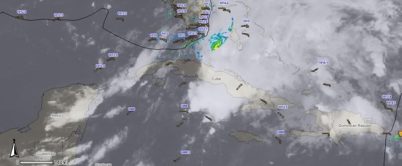
YEP it's a gonner, but there is a little area just North of you Luis to keep an eye on while it's quite here.
Shows nicely on the Vis sat images this morning, but it's very close to a high shear zone.
0 likes
The following post is NOT an official forecast and should not be used as such. It is just the opinion of the poster and may or may not be backed by sound meteorological data. It is NOT endorsed by any professional institution including storm2k.org For Official Information please refer to the NHC and NWS products.
Re: ATL: INVEST 94L - DISCUSSION
Bummer - well, guess I must have smelled the increase in RH on Monday morning...
Seriously, on Monday morning the low was still near it's "peak", for lack of a better term and at that time it did spin a band of low clouds and light showers over extreme Southern Florida, so apparently that was the increase in RH that I sensed at that time...
We really can use the rain and it's disappointing that this didn't work out in our favor - oh, well...
Frank
0 likes
- Portastorm
- Storm2k Moderator
- Posts: 9787
- Age: 61
- Joined: Fri Jul 11, 2003 9:16 am
- Location: South Austin, TX
- Contact:
Re: ATL: INVEST 94L - DISCUSSION
Frank2 wrote:Bummer - well, guess I must have smelled the increase in RH on Monday morning...
Seriously, on Monday morning the low was still near it's "peak", for lack of a better term and at that time it did spin a band of low clouds and light showers over extreme Southern Florida, so apparently that was the increase in RH that I sensed at that time...
We really can use the rain and it's disappointing that this didn't work out in our favor - oh, well...
Frank
Frank, are you sure you weren't just sniffing out your neighbor watering his lawn?!
FWIW, JB is tweeting this morning that the moisture from this system will roll up to Florida. Hope you get some rain. Heck, hope we ALL get some rain soon!
0 likes
Any forecasts under my name are to be taken with a grain of salt. Get your best forecasts from the National Weather Service and National Hurricane Center.
I'm a certified Advanced SKYWARN-trained spotter and am active on Twitter at @TravisCOSW, a social media partner of the NWS Austin-San Antonio office.
Re: ATL: INVEST 94L - DISCUSSION
Someone else asked that question (lol) - no, on Monday morning the sky was mostly cloudy (low clouds) and the humdity high, and it really did smell like rain...
My guess is that the grass is so dry that any increase in humidity will make it smell like rain - that's probably what happened since the convection in the Caribbean made it's closest approach to this area later on Sunday and into Monday...
Frank
My guess is that the grass is so dry that any increase in humidity will make it smell like rain - that's probably what happened since the convection in the Caribbean made it's closest approach to this area later on Sunday and into Monday...
Frank
0 likes
-
- S2K Supporter
- Posts: 500
- Age: 68
- Joined: Tue Sep 30, 2003 10:43 am
- Location: Jupiter, FL
- Contact:
Re: ATL: INVEST 94L - DISCUSSION
Hey Frank! We got some of your rain up in Jupiter this afternoon, so you were correct, just a tad premature.
0 likes
Re: ATL: INVEST 94L - DISCUSSION
Yes, down here it looks like it's about to rain, too, and the radar confirms it - guess my old Indian instincts were a bit slower than usual this time (lol) - serves me right for questioning them, since we should never question the instincts God gives us:
http://radar.weather.gov/ridge/radar.ph ... 1&loop=yes
0 likes
- SouthFloridawx
- S2K Supporter
- Posts: 8344
- Age: 45
- Joined: Tue Jul 26, 2005 1:16 am
- Location: Sarasota, FL
- Contact:
Re: ATL: INVEST 94L - DISCUSSION
Thanks wxman57, looks like that gyre is still spinning around down there.
0 likes
Re: ATL: INVEST 94L - DISCUSSION
NW Caribbean is absent of significant convection but it seems 94L might need to be picked up again in it's new position north of Cuba and Haiti - the ULL over the Gulf of Mexico might pull some of former 94L's weather over Florida in the next 24 hours:
http://www.goes.noaa.gov/HURRLOOPS/huirloop.html
Last edited by Frank2 on Thu Jun 09, 2011 2:55 pm, edited 1 time in total.
0 likes
Re: ATL: INVEST 94L - DISCUSSION
That's okay with us - rain is rain, no matter how it's created (lol), though as you said little chance of a comeback for 94L, which is fine, too...
Frank
Frank
0 likes
- srainhoutx
- S2K Supporter
- Posts: 6919
- Age: 66
- Joined: Sun Jan 14, 2007 11:34 am
- Location: Haywood County, NC
- Contact:
Re: ATL: INVEST 94L - DISCUSSION
Nothing more than a shear axis...HPC:
WHILE ECMWF MEMBERS STILL SHOW AN UPPER LOW/SHEAR AXIS DRIFTING
OUT OF THE ERN GULF TO OFF THE CAROLINA COAST THIS
WEEKEND...ORGANIZED TROPICAL DEVELOPMENT IS NOT EXPECTED WITH THIS
FEATURE AS PER NHC OUTLOOKS. SOME ENHANCEMENT OF DIURNAL
CONVECTION FROM THIS SHEAR AXIS IS POSSIBLE FROM NRN FL ACROSS
COASTAL PORTIONS OF GA AND THE CAROLINAS SUN/MON.
0 likes
Carla/Alicia/Jerry(In The Eye)/Michelle/Charley/Ivan/Dennis/Katrina/Rita/Wilma/Ike/Harvey
Member: National Weather Association
Wx Infinity Forums
http://wxinfinity.com/index.php
Facebook.com/WeatherInfinity
Twitter @WeatherInfinity
Member: National Weather Association
Wx Infinity Forums
http://wxinfinity.com/index.php
Facebook.com/WeatherInfinity
Twitter @WeatherInfinity
- cycloneye
- Admin
- Posts: 139182
- Age: 67
- Joined: Thu Oct 10, 2002 10:54 am
- Location: San Juan, Puerto Rico
Re: ATL: INVEST 94L - DISCUSSION
They may reactivate 94L.
TROPICAL WEATHER OUTLOOK
NWS NATIONAL HURRICANE CENTER MIAMI FL
800 PM EDT THU JUN 9 2011
FOR THE NORTH ATLANTIC...CARIBBEAN SEA AND THE GULF OF MEXICO...
AN ELONGATED AREA OF LOW PRESSURE INTERACTING WITH A LARGE
UPPER-LEVEL TROUGH IS PRODUCING WIDESPREAD CLOUDINESS AND NUMEROUS
SHOWERS OVER THE EXTREME NORTHWESTERN PORTION OF THE CARIBBEAN SEA
AND EXTENDING NORTHEASTWARD ACROSS CENTRAL AND EASTERN CUBA... THE
FLORIDA STRAITS...AND MOST OF THE BAHAMAS. THE AREA OF LOWEST
PRESSURE IS LOCATED JUST NORTH OF GRAND CAYMAN AND THE SYSTEM IS
MOVING TOWARD THE NORTH-NORTHEAST AT 5 TO 10 MPH. UPPER-LEVEL WINDS
ARE CURRENTLY UNFAVORABLE FOR ANY SIGNIFICANT DEVELOPMENT TO
OCCUR...BUT MAY BECOME MARGINALLY FAVORABLE OVER THE NEXT COUPLE OF
DAYS. THERE IS A LOW CHANCE...20 PERCENT...OF THIS SYSTEM BECOMING
A TROPICAL OR SUBTROPICAL CYCLONE DURING THE NEXT 48 HOURS.
ELSEWHERE...TROPICAL CYCLONE FORMATION IS NOT EXPECTED DURING THE
NEXT 48 HOURS.
$$
FORECASTER STEWART
0 likes
Visit the Caribbean-Central America Weather Thread where you can find at first post web cams,radars
and observations from Caribbean basin members Click Here
- cycloneye
- Admin
- Posts: 139182
- Age: 67
- Joined: Thu Oct 10, 2002 10:54 am
- Location: San Juan, Puerto Rico
Re: ATL: INVEST 94L - DISCUSSION
INVEST 94L has been reactivated!
00z Best Track
AL, 94, 2011061000, , BEST, 0, 201N, 813W, 25, 1008, DB
ftp://ftp.tpc.ncep.noaa.gov/atcf/tcweb/ ... 011.invest
00z Best Track
AL, 94, 2011061000, , BEST, 0, 201N, 813W, 25, 1008, DB
ftp://ftp.tpc.ncep.noaa.gov/atcf/tcweb/ ... 011.invest
0 likes
Visit the Caribbean-Central America Weather Thread where you can find at first post web cams,radars
and observations from Caribbean basin members Click Here
- cycloneye
- Admin
- Posts: 139182
- Age: 67
- Joined: Thu Oct 10, 2002 10:54 am
- Location: San Juan, Puerto Rico
Re: ATL: INVEST 94L - MODELS
00z Tropical models for once again 94L
No bright future according to SHIP.
WHXX01 KWBC 100016
CHGHUR
TROPICAL CYCLONE GUIDANCE MESSAGE
NWS NATIONAL HURRICANE CENTER MIAMI FL
0016 UTC FRI JUN 10 2011
DISCLAIMER...NUMERICAL MODELS ARE SUBJECT TO LARGE ERRORS.
PLEASE REFER TO NHC OFFICIAL FORECASTS FOR TROPICAL CYCLONE
AND SUBTROPICAL CYCLONE INFORMATION.
ATLANTIC OBJECTIVE AIDS FOR
DISTURBANCE INVEST (AL942011) 20110610 0000 UTC
...00 HRS... ...12 HRS... ...24 HRS. .. ...36 HRS...
110610 0000 110610 1200 110611 0000 110611 1200
LAT LON LAT LON LAT LON LAT LON
BAMS 20.1N 81.3W 21.0N 81.4W 22.3N 81.3W 23.8N 81.6W
BAMD 20.1N 81.3W 22.9N 79.4W 26.1N 78.6W 29.0N 78.1W
BAMM 20.1N 81.3W 22.0N 80.1W 24.3N 79.6W 26.6N 79.2W
LBAR 20.1N 81.3W 21.5N 80.6W 23.4N 80.2W 25.5N 79.8W
SHIP 25KTS 26KTS 27KTS 23KTS
DSHP 25KTS 24KTS 27KTS 23KTS
...48 HRS... ...72 HRS... ...96 HRS. .. ..120 HRS...
110612 0000 110613 0000 110614 0000 110615 0000
LAT LON LAT LON LAT LON LAT LON
BAMS 25.4N 81.2W 27.7N 78.8W 28.0N 73.4W 28.8N 66.1W
BAMD 31.6N 77.3W 35.4N 72.1W 40.4N 60.0W 46.6N 44.1W
BAMM 28.7N 78.3W 32.0N 74.3W 35.0N 65.8W 41.6N 56.0W
LBAR 27.4N 78.8W 29.0N 74.5W 29.8N 69.0W 33.7N 61.9W
SHIP 18KTS 0KTS 0KTS 0KTS
DSHP 18KTS 0KTS 0KTS 0KTS
...INITIAL CONDITIONS...
LATCUR = 20.1N LONCUR = 81.3W DIRCUR = 45DEG SPDCUR = 4KT
LATM12 = 19.6N LONM12 = 81.9W DIRM12 = 50DEG SPDM12 = 3KT
LATM24 = 19.1N LONM24 = 82.3W
WNDCUR = 25KT RMAXWD = 75NM WNDM12 = 20KT
CENPRS = 1008MB OUTPRS = 1010MB OUTRAD = 150NM SDEPTH = S
RD34NE = 0NM RD34SE = 0NM RD34SW = 0NM RD34NW = 0NM
Uploaded by imageshack.us
0 likes
Visit the Caribbean-Central America Weather Thread where you can find at first post web cams,radars
and observations from Caribbean basin members Click Here
- Hylian Auree
- Tropical Storm
- Posts: 150
- Age: 31
- Joined: Thu Dec 02, 2010 7:01 pm
- Location: Willemstad, Curaçao
- Contact:
94L still has a broad area of surface low pressure, with surface pressures actually slightly lower than 24 hrs ago from the Cayman Islands to central Cuba. Lowest pressure found around the Cayman Islands. Certainly being sheared the heck out of it but as the surface low pressure moves near or north of the Bahamas it might find a little better conditions in the upper levels.
0 likes
Re: ATL: INVEST 94L - DISCUSSION
Broad low pressure near 20.5N-81.5W. Getting sheared to death from the ULL in the eastern gulf which appears to be digging south.
http://www.ssd.noaa.gov/goes/east/gmex/loop-ir2.html
0 likes
Who is online
Users browsing this forum: No registered users and 51 guests