ATL: KATIA - Post Tropical - Discussion

Moderator: S2k Moderators

Message
Author
User avatar
Gustywind
Category 5
Category 5
Posts: 12334
Joined: Mon Sep 03, 2007 7:29 am
Location: Baie-Mahault, GUADELOUPE

Re: Re:

#61 Postby Gustywind » Sun Aug 28, 2011 8:34 am

cycloneye wrote:
Adoquín wrote:of the three the first two affected Puerto Rico, one the Cat 3 going straight through and the third was far away, strong and to the south, enough to cringe. I agree that is too little data to predict anything.

However, I note that being so down south it may take it longer to detatch from the ITZ, which would not be good, The high has tended to be strong. Do for now based on Luis data itcis rational to err on the side of stronger as opposed to lower values. Other parameters hav to be examined. How is Mr. Sal doing? how fast is it moving west? how strong can it get so low based on the precedents mentioned while it remains so low? big questions and depending on the answer another monster?

Puerto Rico hurricanr history has several periods of multiple strikes in a single year by significant hurricanes, mostly on a e or se to wnw direction. It generally happens at least once every century Seversl of those hurricanes ended somewhere in the East Coast , from the. Keys up.


It will be very important to see if by being at low latitude,it avoids any weakness that may be in the Atlantic. The position where it is now reminds me of Georges. :eek: But of course,there is plenty of time to watch it to see how it will track.

Not sweet dreams with Georges Cycloneye :eek: but for sure very low lattitude... is always something to monitor in the Leewards y la isla del encanto. Let's wait and see..
0 likes   

User avatar
cycloneye
Admin
Admin
Posts: 139330
Age: 67
Joined: Thu Oct 10, 2002 10:54 am
Location: San Juan, Puerto Rico

Re: ATL: INVEST 92L - Discussion

#62 Postby cycloneye » Sun Aug 28, 2011 8:39 am

SSD dvorak: Notice how low in latitude it is.

28/1145 UTC 8.8N 22.2W T1.0/1.0 92L -- Atlantic

0 likes   
Visit the Caribbean-Central America Weather Thread where you can find at first post web cams,radars
and observations from Caribbean basin members Click Here

User avatar
crownweather
S2K Supporter
S2K Supporter
Posts: 578
Age: 49
Joined: Sat Aug 12, 2006 9:21 am
Location: Sturbridge, Massachusetts
Contact:

Re: ATL: INVEST 92L - Discussion

#63 Postby crownweather » Sun Aug 28, 2011 8:40 am

Here's something that occurred to me, 92L when it develops would be TD 12 and then Katia (TD 12 became Katrina). Very eerie!!
0 likes   
Rob Lightbown
Crown Weather Services
https://crownweather.com

User avatar
cycloneye
Admin
Admin
Posts: 139330
Age: 67
Joined: Thu Oct 10, 2002 10:54 am
Location: San Juan, Puerto Rico

Re: ATL: INVEST 92L - Models

#64 Postby cycloneye » Sun Aug 28, 2011 8:45 am

12z Tropical Models.

Code: Select all

WHXX01 KWBC 281339
CHGHUR
TROPICAL CYCLONE GUIDANCE MESSAGE
NWS NATIONAL HURRICANE CENTER MIAMI FL
1339 UTC SUN AUG 28 2011
 
DISCLAIMER...NUMERICAL MODELS ARE SUBJECT TO LARGE ERRORS.
PLEASE REFER TO NHC OFFICIAL FORECASTS FOR TROPICAL CYCLONE
AND SUBTROPICAL CYCLONE INFORMATION.
 
ATLANTIC OBJECTIVE AIDS FOR
 
DISTURBANCE INVEST (AL922011) 20110828 1200 UTC
 
        ...00 HRS...   ...12 HRS...   ...24 HRS. ..   ...36 HRS...
        110828  1200   110829  0000   110829  1200   110830  0000
 
         LAT    LON     LAT    LON     LAT    LON     LAT    LON
BAMS    10.5N  21.5W   10.5N  23.7W   10.5N  26.4W   10.5N  29.4W
BAMD    10.5N  21.5W   10.6N  24.1W   10.9N  26.9W   11.1N  29.6W
BAMM    10.5N  21.5W   10.6N  24.0W   10.8N  26.7W   10.9N  29.4W
LBAR    10.5N  21.5W   10.6N  24.2W   10.8N  27.4W   11.5N  30.8W
SHIP        25KTS          33KTS          42KTS          49KTS
DSHP        25KTS          33KTS          42KTS          49KTS
 
        ...48 HRS...   ...72 HRS...   ...96 HRS. ..   ..120 HRS...
        110830  1200   110831  1200   110901  1200   110902  1200
 
         LAT    LON     LAT    LON     LAT    LON     LAT    LON
BAMS    10.4N  32.3W    9.9N  36.2W   10.5N  37.4W   14.2N  38.9W
BAMD    11.3N  32.5W   11.4N  37.5W   10.9N  41.6W   11.1N  44.4W
BAMM    11.0N  32.1W   10.9N  36.0W   11.4N  38.2W   14.1N  40.8W
LBAR    12.5N  34.1W   14.9N  40.3W   14.5N  45.0W   13.5N  44.2W
SHIP        55KTS          63KTS          67KTS          74KTS
DSHP        55KTS          63KTS          67KTS          74KTS
 
         ...INITIAL CONDITIONS...
LATCUR =  10.5N LONCUR =  21.5W DIRCUR = 270DEG SPDCUR =  11KT
LATM12 =  10.4N LONM12 =  19.3W DIRM12 = 268DEG SPDM12 =  11KT
LATM24 =  10.4N LONM24 =  16.9W
WNDCUR =   25KT RMAXWD =   90NM WNDM12 =   20KT
CENPRS = 1010MB OUTPRS = 1013MB OUTRAD =  180NM SDEPTH =   S
RD34NE =    0NM RD34SE =    0NM RD34SW =    0NM RD34NW =   0NM
 
0 likes   
Visit the Caribbean-Central America Weather Thread where you can find at first post web cams,radars
and observations from Caribbean basin members Click Here

User avatar
cycloneye
Admin
Admin
Posts: 139330
Age: 67
Joined: Thu Oct 10, 2002 10:54 am
Location: San Juan, Puerto Rico

Re: ATL: INVEST 92L - Discussion

#65 Postby cycloneye » Sun Aug 28, 2011 8:50 am

Now, which agency is right on the position? A big difference.

SSD dvorak has this:

28/1145 UTC 8.8N 22.2W T1.0/1.0 92L -- Atlantic

http://www.ssd.noaa.gov/PS/TROP/tdpositions.html

12z Best Track has this:

AL, 92, 2011082812, , BEST, 0, 105N, 215W, 25, 1010, DB

ftp://ftp.tpc.ncep.noaa.gov/atcf/tcweb/ ... 011.invest
0 likes   
Visit the Caribbean-Central America Weather Thread where you can find at first post web cams,radars
and observations from Caribbean basin members Click Here

shaggy
Category 2
Category 2
Posts: 655
Joined: Fri Jul 22, 2005 4:14 pm
Location: greenville, n.c.

Re: ATL: INVEST 92L - Discussion

#66 Postby shaggy » Sun Aug 28, 2011 8:55 am

cycloneye wrote:Now, which agency is right on the position? A big difference.

SSD dvorak has this:

28/1145 UTC 8.8N 22.2W T1.0/1.0 92L -- Atlantic

http://www.ssd.noaa.gov/PS/TROP/tdpositions.html

12z Best Track has this:

AL, 92, 2011082812, , BEST, 0, 105N, 215W, 25, 1010, DB

ftp://ftp.tpc.ncep.noaa.gov/atcf/tcweb/ ... 011.invest


We saw with Irene how much a small difference in a center location can change the path it takes. If it is down around 8.8N then an early recurve would be harder IMO.
0 likes   

User avatar
cycloneye
Admin
Admin
Posts: 139330
Age: 67
Joined: Thu Oct 10, 2002 10:54 am
Location: San Juan, Puerto Rico

Re: ATL: INVEST 92L - Models

#67 Postby cycloneye » Sun Aug 28, 2011 9:03 am

12z models graphic. Saved image.

Image
0 likes   
Visit the Caribbean-Central America Weather Thread where you can find at first post web cams,radars
and observations from Caribbean basin members Click Here

User avatar
SEASON_CANCELED
Category 3
Category 3
Posts: 887
Joined: Mon Jul 06, 2009 5:17 am
Location: 8 Bit Charlie Sheen

Re: ATL: INVEST 92L - Models

#68 Postby SEASON_CANCELED » Sun Aug 28, 2011 9:19 am

Models are awfully goofy. Gonna need to wait a week. Think alot of it depends on formation..
0 likes   
i am a big stupid ugly moron with an ugly face and a big butt and my butt stinks and i like to kiss my own butt

hurricaneCW
Category 5
Category 5
Posts: 1773
Joined: Wed Mar 03, 2010 6:20 am
Location: Toms River, NJ

Re: ATL: INVEST 92L - Models

#69 Postby hurricaneCW » Sun Aug 28, 2011 9:22 am

Models tend to adjust westward over time with this far eastern Atlantic system so we have to wait and see what happens.
0 likes   

User avatar
cycloneye
Admin
Admin
Posts: 139330
Age: 67
Joined: Thu Oct 10, 2002 10:54 am
Location: San Juan, Puerto Rico

Re: ATL: INVEST 92L - Discussion

#70 Postby cycloneye » Sun Aug 28, 2011 9:28 am

:uarrow: I would like to see clarification in the 18z updates from both on one position.
0 likes   
Visit the Caribbean-Central America Weather Thread where you can find at first post web cams,radars
and observations from Caribbean basin members Click Here

User avatar
DelrayMorris
S2K Supporter
S2K Supporter
Posts: 95
Joined: Sat Sep 06, 2003 11:51 pm
Location: Delray Beach, FL

Re: ATL: INVEST 92L - Models

#71 Postby DelrayMorris » Sun Aug 28, 2011 9:36 am

Too tired to watch it now... I think I'll start paying closer attention in a few days. It's been a long week!
0 likes   

User avatar
Meteorcane
Category 2
Category 2
Posts: 541
Joined: Thu Jul 21, 2011 6:49 am
Location: North Platte Nebraska

Re: ATL: INVEST 92L - Models

#72 Postby Meteorcane » Sun Aug 28, 2011 9:39 am

This thing is really far south I am skeptical of a recurve before the islands with this one.
0 likes   

User avatar
wxman57
Moderator-Pro Met
Moderator-Pro Met
Posts: 22484
Age: 66
Joined: Sat Jun 21, 2003 8:06 pm
Location: Houston, TX (southwest)

Re: ATL: INVEST 92L - Models

#73 Postby wxman57 » Sun Aug 28, 2011 9:49 am

The ridge to its north should be a lot weaker than the ridge north of Irene, as is already quite evident by the lack of any significant SAL:
http://tropic.ssec.wisc.edu/real-time/sal/splitEW.jpg

I think it will most likely track north of the Caribbean, though I won't rule out any impact at this time. Good chance it would recurve east of the U.S., but I'm wary of the Euro, which did such a good job with Irene 10 days out, taking this storm toward the eastern Bahamas in 10 days.
0 likes   

User avatar
Gustywind
Category 5
Category 5
Posts: 12334
Joined: Mon Sep 03, 2007 7:29 am
Location: Baie-Mahault, GUADELOUPE

#74 Postby Gustywind » Sun Aug 28, 2011 9:51 am

Latest from NRL:

20110828.1400.92LINVEST.25kts-1010mb-105N-215W
0 likes   

RL3AO
Moderator-Pro Met
Moderator-Pro Met
Posts: 16308
Joined: Thu Jun 14, 2007 10:03 pm
Location: NC

#75 Postby RL3AO » Sun Aug 28, 2011 9:53 am

NRL just uses the ATCF data.
0 likes   

User avatar
cycloneye
Admin
Admin
Posts: 139330
Age: 67
Joined: Thu Oct 10, 2002 10:54 am
Location: San Juan, Puerto Rico

Re: ATL: INVEST 92L - Discussion

#76 Postby cycloneye » Sun Aug 28, 2011 9:56 am

It would be good to have a pro met explaining about why a big difference on a position (Almost two degrees in latitude) between SSD dvorak and ATCF.
0 likes   
Visit the Caribbean-Central America Weather Thread where you can find at first post web cams,radars
and observations from Caribbean basin members Click Here

User avatar
NDG
S2K Supporter
S2K Supporter
Posts: 14933
Joined: Sun Jul 09, 2006 10:14 pm
Location: Orlando, FL

#77 Postby NDG » Sun Aug 28, 2011 10:20 am

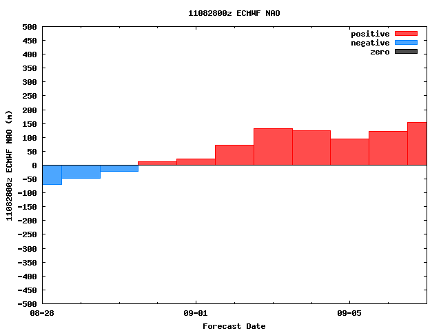
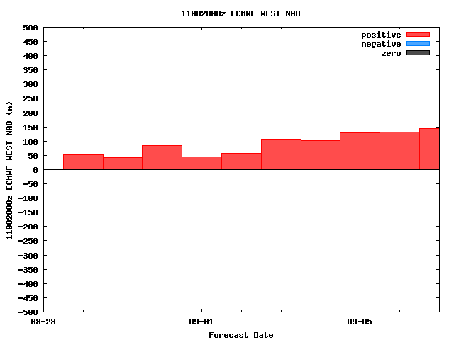
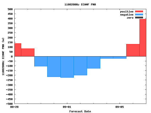
Very concerning teleconnections forecasted by the ECMWF in its long range forecast, with possibly Atlantic ridging setting up closer to the eastern US, ridging in the western N. American Pacifific coast would mean that the through would be in the central US not eastern US. This could mean a threat further west compared with Irene at least to FL if not the gulf coast. And with the Texan ridge expected to die down adds to my concern.
Nothing to be alarmed about right now as the euro is not that perfect in its long range forecast, just something to watch for now.

Image
Image
Image


Personal Forecast Disclaimer:
The posts in this forum are NOT official forecast and should not be used as such. They are just the opinion of the poster and may or may not be backed by sound meteorological data. They are NOT endorsed by any professional institution or storm2k.org. For official information, please refer to the NHC and NWS products.
0 likes   

User avatar
ROCK
Category 5
Category 5
Posts: 9254
Age: 53
Joined: Tue Aug 17, 2004 7:30 am
Location: Kemah, Texas

Re: ATL: INVEST 92L - Discussion

#78 Postby ROCK » Sun Aug 28, 2011 10:36 am

a 8.5 is really low and would be a low lat crusier thrown the catib IMO....hard for a a trof to dig something that low up and out.....for the record this one gives me the willies...
0 likes   

User avatar
cycloneye
Admin
Admin
Posts: 139330
Age: 67
Joined: Thu Oct 10, 2002 10:54 am
Location: San Juan, Puerto Rico

Re: ATL: INVEST 92L - Models

#79 Postby cycloneye » Sun Aug 28, 2011 10:38 am

GFS ensembles.

Saved image.

Image
0 likes   
Visit the Caribbean-Central America Weather Thread where you can find at first post web cams,radars
and observations from Caribbean basin members Click Here

User avatar
HurricaneMaster_PR
Category 2
Category 2
Posts: 795
Joined: Tue Jul 22, 2003 6:23 pm
Location: San Juan, Puerto Rico

Re: ATL: INVEST 92L - Discussion

#80 Postby HurricaneMaster_PR » Sun Aug 28, 2011 11:02 am

TAFB Surface Forecast.

Look where they have it in 72 hours (the X with the 1007mb). Moving to the west southwest.

Image

Uploaded with ImageShack.us
0 likes   


Return to “2011”

Who is online

Users browsing this forum: No registered users and 11 guests