EPAC: DORA - Remnants
Moderator: S2k Moderators
-
cycloneye

- Admin

- Posts: 139334
- Age: 67
- Joined: Thu Oct 10, 2002 10:54 am
- Location: San Juan, Puerto Rico
Re: EPAC: DORA - Hurricane
HURRICANE DORA DISCUSSION NUMBER 11
NWS NATIONAL HURRICANE CENTER MIAMI FL EP042011
800 PM PDT WED JUL 20 2011
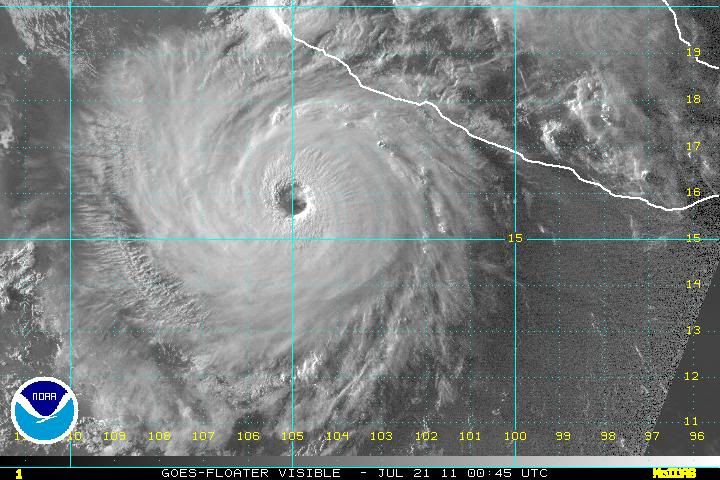
DORA CONTINUED TO RAPIDLY STRENGTHEN THIS AFTERNOON. SATELLITE
IMAGERY SHOWS VERY DEEP CONVECTION SURROUNDING A 25-30 N MI-WIDE
EYE THAT HAS WARMED AND BECOME MUCH BETTER DEFINED. OBJECTIVE
DVORAK T-NUMBERS FROM UW-CIMSS HAVE NOW INCREASED TO T6.2. THE
MOST RECENT SUBJECTIVE DVORAK T-NUMBERS OF T5.5 WERE A LITTLE LOWER
THAN THE OBJECTIVE NUMBERS...BECAUSE THE COLDEST RING OF CONVECTION
AROUND THE EYE ON THE 2345 UTC SATELLITE IMAGE HAD A FEW BREAKS.
BASED ON THE OBJECTIVE ESTIMATES THE INITIAL INTENSITY HAS BEEN
INCREASED TO 115 KT.
DORA HAS TIME FOR SOME ADDITIONAL STRENGTHENING AS IT WILL REMAIN
OVER 28-29 DEGREE CELSIUS SSTS AND IN A LOW SHEAR ENVIRONMENT FOR
ANOTHER 24 HOURS. THE NHC INTENSITY FORECAST IS NEAR THE UPPER END
OF THE GUIDANCE AND CALLS FOR PEAK INTENSITY OF 125 KT. WEAKENING
SHOULD BEGIN BETWEEN 24 AND 36 HOURS AS THE HURRICANE MOVES OVER
DECREASING SSTS. A MUCH FASTER RATE OF WEAKENING IS EXPECTED AFTER
TWO DAYS AS DORA EXPLORES THE COLDER WATERS OF THE EASTERN
PACIFIC.
THE INITIAL MOTION ESTIMATE IS 295/14. A TURN TOWARD THE NORTHWEST
WITH A REDUCTION IN FORWARD SPEED SHOULD OCCUR VERY SOON AS THE
RIDGE OVER THE CENTRAL UNITED STATES SHIFTS EASTWARD AND WEAKENS.
THEREAFTER...DORA IS FORECAST TO MAINTAIN A HEADING BETWEEN
NORTHWEST AND WEST-NORTHWEST UNTIL IT BECOMES A POST-TROPICAL
REMNANT LOW IN ABOUT 5 DAYS. THE TRACK GUIDANCE CONTINUES TO HAVE
SOME CONSISTENCY ISSUES WITH NOTABLE EAST-WEST SHIFTS OCCURRING
FROM RUN TO RUN DURING THE PAST DAY OR SO. THE LATEST GUIDANCE
SHIFTED BACK EASTWARD...BUT FOR NOW THE NHC FORECAST WILL MAINTAIN
CONTINUITY WITH THE PREVIOUS FORECAST AND IS IN BEST AGREEMENT
WITHIN THE ECMWF.
FORECAST POSITIONS AND MAX WINDS
INIT 21/0300Z 16.0N 105.4W 115 KT 135 MPH
12H 21/1200Z 17.0N 106.7W 125 KT 145 MPH
24H 22/0000Z 18.2N 108.2W 125 KT 145 MPH
36H 22/1200Z 19.1N 109.4W 110 KT 125 MPH
48H 23/0000Z 19.9N 110.6W 90 KT 105 MPH
72H 24/0000Z 21.5N 113.5W 60 KT 70 MPH
96H 25/0000Z 23.0N 117.0W 30 KT 35 MPH
120H 26/0000Z 25.0N 120.5W 25 KT 30 MPH...POST-TROP/REMNT LOW
$$
FORECASTER BROWN
0 likes
Visit the Caribbean-Central America Weather Thread where you can find at first post web cams,radars
and observations from Caribbean basin members Click Here
and observations from Caribbean basin members Click Here
-
Yellow Evan

- Professional-Met

- Posts: 15956
- Age: 25
- Joined: Fri Jul 15, 2011 12:48 pm
- Location: Henderson, Nevada/Honolulu, HI
- Contact:
-
Hurricane Jed

- Category 2

- Posts: 542
- Age: 36
- Joined: Mon Jan 24, 2011 3:36 pm
- Location: Cen Tex
-
Rgv20

- S2K Supporter

- Posts: 2456
- Age: 37
- Joined: Wed Jan 05, 2011 5:42 pm
- Location: Edinburg/McAllen Tx
What a beautiful visible pic of Hurricane Dora 
0 likes
The following post is NOT an official forecast and should not be used as such. It is just the opinion of the poster and may or may not be backed by sound meteorological data. It is NOT endorsed by any professional institution including storm2k.org For Official Information please refer to the NHC and NWS products.
-
brunota2003

- S2K Supporter
- Posts: 9476
- Age: 33
- Joined: Sat Jul 30, 2005 9:56 pm
- Location: Stanton, KY...formerly Havelock, NC
- Contact:


-
MGC

- S2K Supporter
- Posts: 5794
- Joined: Sun Mar 23, 2003 9:05 pm
- Location: Pass Christian MS, or what is left.
Re: EPAC: DORA - Hurricane
Yes it looks like Dora is shrinking....a sign of continued intensification. Would not be surprixed if the next advisory is up around 145mph.....beautiful hurricane......MGC
0 likes
-
SouthFloridawx

- S2K Supporter
- Posts: 8344
- Age: 45
- Joined: Tue Jul 26, 2005 1:16 am
- Location: Sarasota, FL
- Contact:
Re:
They totally knew when they wrote that... Though how many chances would you in an official NHC discussion.
brunota2003 wrote:A MUCH FASTER RATE OF WEAKENING IS EXPECTED AFTER
TWO DAYS AS DORA EXPLORES THE COLDER WATERS OF THE EASTERN
PACIFIC.
"SWIPER NO SWIPING! SWIPER NO SWIPING! SWIPER NO-" "You're too late! Now you'll never find the warm waters of the East Pacific!"
0 likes
Re: EPAC: DORA - Hurricane
Looking more and more like a doughnut, will it become annular? I know that's a controversial word for some people on this board but we can't ignore the characteristics that Dora is presenting.
0 likes
-
Kingarabian

- S2K Supporter
- Posts: 15451
- Joined: Sat Aug 08, 2009 3:06 am
- Location: Honolulu, Hawaii
http://www.ssd.noaa.gov/goes/flt/t6/flash-avn.html
Clearly you can see it shrinking while its eye keeps on getting bigger,
Clearly you can see it shrinking while its eye keeps on getting bigger,
0 likes
RIP Kobe Bryant
-
Battlebrick
- Tropical Storm

- Posts: 177
- Joined: Thu Sep 02, 2010 9:55 pm
Re: EPAC: DORA - Hurricane
So what does the /obvious/ shrinking in size mean? Strengthening? Weakening?
0 likes
Lim_Fao on IRC.
The following post is NOT an official forecast and should not be used as such. It is just the opinion of the poster and may or may not be backed by sound meteorological data. It is NOT endorsed by any professional institution including storm2k.org. For Official Information please refer to the NHC and NWS products.
The following post is NOT an official forecast and should not be used as such. It is just the opinion of the poster and may or may not be backed by sound meteorological data. It is NOT endorsed by any professional institution including storm2k.org. For Official Information please refer to the NHC and NWS products.

Re: EPAC: DORA - Hurricane
What an impressive hurricane! I notice EPAC are more likely to be major hurricanes.
0 likes
Re: EPAC: DORA - Hurricane
Battlebrick wrote:So what does the /obvious/ shrinking in size mean? Strengthening? Weakening?
Strengthening, and the big size of the eye could mean it's becoming annular, those hurricanes resist better the cooler waters and the wind shear.
0 likes
-
somethingfunny

- ChatStaff

- Posts: 3926
- Age: 35
- Joined: Thu May 31, 2007 10:30 pm
- Location: McKinney, Texas
It does seem to be taking on annular characteristics - it must not be aware that annular cane are supposed to be long-lived, which Dora will not be. 
0 likes
I am not a meteorologist, and any posts made by me are not official forecasts or to be interpreted as being intelligent. These posts are just my opinions and are probably silly opinions.


-
Kingarabian
- S2K Supporter
- Posts: 15451
- Joined: Sat Aug 08, 2009 3:06 am
- Location: Honolulu, Hawaii
Re: EPAC: DORA - Hurricane
Anyone else thinks this is more than a 135mph storm?
LMAO glad to know that the NHC has a sense of humor.
brunota2003 wrote:A MUCH FASTER RATE OF WEAKENING IS EXPECTED AFTER
TWO DAYS AS DORA EXPLORES THE COLDER WATERS OF THE EASTERN
PACIFIC.
"SWIPER NO SWIPING! SWIPER NO SWIPING! SWIPER NO-" "You're too late! Now you'll never find the warm waters of the East Pacific!"
LMAO glad to know that the NHC has a sense of humor.
0 likes
RIP Kobe Bryant
-
Blown Away

- S2K Supporter
- Posts: 9867
- Joined: Wed May 26, 2004 6:17 am
Re: EPAC: DORA - Hurricane
How beautiful is Dora, I loved watching Dora tighten up over the last few IR frames, very cool! IMO maybe approaching Cat 5??
0 likes
Hurricane Eye Experience: David 79, Irene 99, Frances 04, Jeanne 04, Wilma 05... EYE COMING MY WAY IN 2024…
Hurricane Brush Experience: Andrew 92, Erin 95, Floyd 99, Matthew 16, Irma 17, Ian 22, Nicole 22…
Hurricane Brush Experience: Andrew 92, Erin 95, Floyd 99, Matthew 16, Irma 17, Ian 22, Nicole 22…
-
dwsqos2
Re: EPAC: DORA - Hurricane
The ADT estimate has actually decreased a bit, and subjective estimates aren't even near 7.0. So, I don't think category five is likely.
0 likes

-
Kingarabian
- S2K Supporter
- Posts: 15451
- Joined: Sat Aug 08, 2009 3:06 am
- Location: Honolulu, Hawaii
Who is online
Users browsing this forum: No registered users and 6 guests