ATL: KATIA - Post Tropical - Discussion

Moderator: S2k Moderators

Message
Author
User avatar
SFLcane
S2K Supporter
S2K Supporter
Posts: 9617
Age: 46
Joined: Sat Jun 05, 2010 1:44 pm
Location: Lake Worth Florida

Re: ATL: INVEST 92L - Models

#21 Postby SFLcane » Sat Aug 27, 2011 9:23 pm

Could be luis...One thing is for sure models for the time being are faily aggresive in terms of development.

Experimnetal FIM is also developing it and turns northward pretty quickly.

http://fim.noaa.gov/FIMscp/Welcome.cgi?dsKey=fim&domain=244&run_time=27+Aug+2011+-+12Z

Image
0 likes   

User avatar
cycloneye
Admin
Admin
Posts: 139329
Age: 67
Joined: Thu Oct 10, 2002 10:54 am
Location: San Juan, Puerto Rico

Re: ATL: INVEST 92L - Discussion

#22 Postby cycloneye » Sat Aug 27, 2011 9:36 pm

HurricaneMaster_PR wrote:Given its low latitude (near 10N) we should monitor this system closely, specially us in the islands. A stronger system like the GFS is forecasting will possibly recurve, but if this system is not as deep as the GFS is forecasting it in the next 72 hours then a more westward track should be more plausible.

For now, lets just keep watching it..

The posts in this forum are NOT official forecast and should not be used as such. They are just the opinion of the poster and may or may not be backed by sound meteorological data. They are NOT endorsed by any professional institution or storm2k.org. For official information, please refer to the NHC and NWS products.

I agree with that. We will have to watch it, but I guess it all hinges on how strong or not the high pressure will be in the next few days in terms of track.
0 likes   
Visit the Caribbean-Central America Weather Thread where you can find at first post web cams,radars
and observations from Caribbean basin members Click Here

User avatar
Ptarmigan
Category 5
Category 5
Posts: 5273
Joined: Wed Aug 16, 2006 9:06 pm

Re: ATL: INVEST 92L - Discussion

#23 Postby Ptarmigan » Sat Aug 27, 2011 9:48 pm

Future Jose. Longer it takes to develop, the more west 92L could go. If I recall, Ike formed further north of 92L and it went westward despite being a hurricane. Ike was tagged as Invest 97L.
Last edited by Ptarmigan on Sat Aug 27, 2011 9:55 pm, edited 1 time in total.
0 likes   

User avatar
BigA
Professional-Met
Professional-Met
Posts: 1317
Joined: Sun Jul 24, 2005 10:56 pm

Re: ATL: INVEST 92L - Discussion

#24 Postby BigA » Sat Aug 27, 2011 9:53 pm

If this develops at 8 north it might have a hardere time feeling weakness. Will do a stat analysis of east Atlantic storms that formed below ten later tonight or tomorrow.
0 likes   

User avatar
cycloneye
Admin
Admin
Posts: 139329
Age: 67
Joined: Thu Oct 10, 2002 10:54 am
Location: San Juan, Puerto Rico

Re: ATL: INVEST 92L - Discussion

#25 Postby cycloneye » Sat Aug 27, 2011 9:53 pm

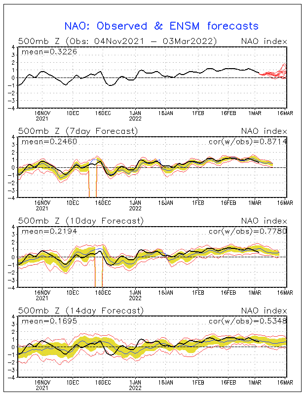
It appears that the ridge may be relativly strong if the NAO forecast is right about being neutral to slightly positive.

Image
0 likes   
Visit the Caribbean-Central America Weather Thread where you can find at first post web cams,radars
and observations from Caribbean basin members Click Here

User avatar
Jevo
S2K Supporter
S2K Supporter
Posts: 1729
Age: 46
Joined: Tue Aug 03, 2004 8:45 pm
Location: The Flemish Cap
Contact:

#26 Postby Jevo » Sat Aug 27, 2011 9:55 pm

LoL see what I was talking about with that ECMWF @ 8 days
0 likes   
Disclaimer: 50% of the time I have no clue of what I am talking about. Chances are I am taking a less than educated guess that sounds good because 10 years ago I stole Mike Watkins book 'The Hurricane and its Impact'. For official information please direct yourself to the NHC and their cadre of weather geniuses.

User avatar
GCANE
S2K Supporter
S2K Supporter
Posts: 10787
Joined: Mon Oct 22, 2007 8:03 am

Re: ATL: INVEST 92L - Discussion

#27 Postby GCANE » Sat Aug 27, 2011 9:57 pm

cycloneye wrote:
HurricaneMaster_PR wrote:Given its low latitude (near 10N) we should monitor this system closely, specially us in the islands. A stronger system like the GFS is forecasting will possibly recurve, but if this system is not as deep as the GFS is forecasting it in the next 72 hours then a more westward track should be more plausible.

For now, lets just keep watching it..

The posts in this forum are NOT official forecast and should not be used as such. They are just the opinion of the poster and may or may not be backed by sound meteorological data. They are NOT endorsed by any professional institution or storm2k.org. For official information, please refer to the NHC and NWS products.


I agree with that. We will have to watch it, but I guess it all hinges on how strong or not the high pressure will be in the next few days in terms of track.


MIMIC-TPW shows good convergence and it is low.

http://cimss.ssec.wisc.edu/tropic/real- ... /main.html
0 likes   

User avatar
cycloneye
Admin
Admin
Posts: 139329
Age: 67
Joined: Thu Oct 10, 2002 10:54 am
Location: San Juan, Puerto Rico

Re: ATL: INVEST 92L - Discussion

#28 Postby cycloneye » Sat Aug 27, 2011 10:15 pm

You can see the circulation in this loop.

http://rammb.cira.colostate.edu/ramsdis ... r2_floater
0 likes   
Visit the Caribbean-Central America Weather Thread where you can find at first post web cams,radars
and observations from Caribbean basin members Click Here

User avatar
ROCK
Category 5
Category 5
Posts: 9254
Age: 53
Joined: Tue Aug 17, 2004 7:30 am
Location: Kemah, Texas

Re: ATL: INVEST 92L - Models

#29 Postby ROCK » Sat Aug 27, 2011 10:18 pm

cycloneye wrote:Adrian,that has to be an error by the Bams as they go west and turn right in a heartbeat.


yeah those 0z BAM are posted wrong....almost a south of west motion and at a low lat also
0 likes   

User avatar
ConvergenceZone
Category 5
Category 5
Posts: 4833
Joined: Fri Jul 29, 2005 1:40 am
Location: Northern California

Re:

#30 Postby ConvergenceZone » Sat Aug 27, 2011 10:24 pm

HurricaneWarning92 wrote:Lol no idea, but he posted on twitter which sounded confident that the pattern will be there to shove it to the east coast: "East coast: next hurricane threat coming in 12-16 days! Euro now seeing it. I wasnt kidding around about this pattern" -Joe Bastardi


I like JB, he's a kick to watch and listen to, but the problem regarding his 92L forecast is that he never looks at what the models are forecasting, he just mentions right out of the blue that it will threaten the east coast....
0 likes   

User avatar
BigA
Professional-Met
Professional-Met
Posts: 1317
Joined: Sun Jul 24, 2005 10:56 pm

Re: ATL: INVEST 92L - Discussion

#31 Postby BigA » Sat Aug 27, 2011 11:38 pm

These statistics may not be of any real relevance, but they might be worth noting.

Since 1968 (I wanted to use data from the satellite era), ten tropical storms and hurricanes have formed from depressions first classified south of 10N and east of 35W.

Of these, six grew into hurricanes. None of the ones that did not become hurricanes significantly affected land.

The three hurricanes in this example are Bertha (1996), Georges (1998) and Ivan (2004).

Therefore, it is really not possible to say whether a storm that forms far to the south has a greater chance of affecting land, as there are too few storms that formed in that place.
0 likes   

bexar
Tropical Storm
Tropical Storm
Posts: 182
Joined: Sat Aug 20, 2011 11:23 am

ATL: INVEST 92L - Models

#32 Postby bexar » Sat Aug 27, 2011 11:38 pm

will this suffer the same fate as 90L? are the conditions ahead still unfavorable?
0 likes   

User avatar
BigA
Professional-Met
Professional-Met
Posts: 1317
Joined: Sun Jul 24, 2005 10:56 pm

#33 Postby BigA » Sat Aug 27, 2011 11:54 pm

00 GFS is marginally farther west than 18Z run: Gets to 57 west rather than 49 in the 18Z ru. Still a fish, though.
0 likes   

Adoquín
Tropical Storm
Tropical Storm
Posts: 140
Joined: Thu Jul 28, 2011 8:47 pm

#34 Postby Adoquín » Sun Aug 28, 2011 12:07 am

of the three the first two affected Puerto Rico, one the Cat 3 going straight through and the third was far away, strong and to the south, enough to cringe. I agree that is too little data to predict anything.

However, I note that being so down south it may take it longer to detatch from the ITZ, which would not be good, The high has tended to be strong. Do for now based on Luis data itcis rational to err on the side of stronger as opposed to lower values. Other parameters hav to be examined. How is Mr. Sal doing? how fast is it moving west? how strong can it get so low based on the precedents mentioned while it remains so low? big questions and depending on the answer another monster?

Puerto Rico hurricanr history has several periods of multiple strikes in a single year by significant hurricanes, mostly on a e or se to wnw direction. It generally happens at least once every century Seversl of those hurricanes ended somewhere in the East Coast , from the. Keys up.
0 likes   

Adoquín
Tropical Storm
Tropical Storm
Posts: 140
Joined: Thu Jul 28, 2011 8:47 pm

#35 Postby Adoquín » Sun Aug 28, 2011 12:12 am

sorry for the typos and for forgetting the most important part of that story: we are grossly ovedue for that happening again, by about a 100 years or so. So, Hurakan should post the bear.
0 likes   

User avatar
FireRat
Category 5
Category 5
Posts: 1138
Age: 36
Joined: Sun Sep 26, 2010 11:38 pm
Location: North Carolina

Re: ATL: INVEST 92L - Discussion

#36 Postby FireRat » Sun Aug 28, 2011 1:55 am

Hi S2k members, I analyzed September via my "natural disaster date" method and wanted to share that the next potential hurricane risk dates are September 3rd-6th with the 3rd,4th and 6th being most notable. It will be interesting to see if they coincide with anything this invest 92L will do if it forms by then. I figured I could provide this info as a backup to any models that foresee a landfall during these dates.

Looking at the timing, it may be something for the Leewards/PR if it were to form into Jose huh?

It's far out on a limb but I predict a possible impact coming from a storm down the road between 9/3 and 9/6 in the eastern Caribbean Islands as hurricane, perhaps strong hurricane on 9/4. This may come from 92L or whatever follows it. This is just my opinion, so in case this invest does develop...you know the drill.....listen to NHC. Just wanted to share this with all of you. I hope it helps in some way. :)

The posts in this forum are NOT official forecast and should not be used as such. They are just the opinion of the poster and may or may not be backed by sound meteorological data. They are NOT endorsed by any professional institution or storm2k.org. For official information, please refer to the NHC and NWS products.
0 likes   
Georges '98, Irene '99, Frances '04, Jeanne '04, Katrina '05, Wilma '05, Gustav '08, Isaac '12, Matthew '16, Florence '18, Michael '18, Ian '22

blazess556
Professional-Met
Professional-Met
Posts: 250
Joined: Mon Aug 31, 2009 10:51 pm
Location: Germantown, MD

#37 Postby blazess556 » Sun Aug 28, 2011 2:03 am

00z euro has this east of the bahamas at 240 with ridging overhead.
0 likes   

Adoquín
Tropical Storm
Tropical Storm
Posts: 140
Joined: Thu Jul 28, 2011 8:47 pm

#38 Postby Adoquín » Sun Aug 28, 2011 3:09 am

can you figure out from what direction it is coming from, se perhaps? How east and sourh?
0 likes   

User avatar
southerngale
Retired Staff
Retired Staff
Posts: 27420
Joined: Thu Oct 10, 2002 1:27 am
Location: Southeast Texas (Beaumont area)

Re:

#39 Postby southerngale » Sun Aug 28, 2011 3:20 am

Adoquín wrote:can you figure out from what direction it is coming from, se perhaps? How east and sourh?


Here's the link so you can see the full loop: 0z ECMWF


0z ECMWF @ 240 hours
Image
0 likes   
Please support Storm2k by making a donation today. It is greatly appreciated! Click here: Image

Image my Cowboys Image my RocketsImage my Astros

User avatar
abajan
S2K Supporter
S2K Supporter
Posts: 4175
Joined: Sun Sep 07, 2003 5:10 am
Location: Barbados

Re: ATL: INVEST 92L - Discussion

#40 Postby abajan » Sun Aug 28, 2011 3:33 am

Now given a medium chance of development over the next 48 hours, folks.

000
ABNT20 KNHC 280557
TWOAT

TROPICAL WEATHER OUTLOOK
NWS NATIONAL HURRICANE CENTER MIAMI FL
200 AM EDT SUN AUG 28 2011

FOR THE NORTH ATLANTIC...CARIBBEAN SEA AND THE GULF OF MEXICO...

THE NATIONAL HURRICANE CENTER IS ISSUING ADVISORIES ON HURRICANE
IRENE...LOCATED ABOUT 15 MILES SOUTH-SOUTHEAST OF OCEAN CITY
MARYLAND.

A TROPICAL WAVE CENTERED A FEW HUNDRED MILES SOUTHEAST OF THE CAPE
VERDE ISLANDS IS PRODUCING A LARGE AREA OF SHOWERS AND
THUNDERSTORMS. ENVIRONMENTAL CONDITIONS APPEAR CONDUCIVE FOR
DEVELOPMENT OF THIS WAVE DURING THE NEXT COUPLE OF DAYS AS IT MOVES
WESTWARD AT 10 MPH. THIS SYSTEM HAS A MEDIUM CHANCE...30
PERCENT
...OF BECOMING A TROPICAL CYCLONE DURING THE NEXT 48 HOURS.

A SMALL LOW PRESSURE SYSTEM LOCATED ABOUT 200 MILES SOUTH OF BERMUDA
IS PRODUCING BURSTS OF SHOWERS AND THUNDERSTORMS AND WINDS TO NEAR
GALE FORCE ON ITS SOUTHEAST SIDE. HOWEVER...UPPER-LEVEL WINDS ARE
EXTREMELY UNFAVORABLE FOR FURTHER DEVELOPMENT OF THIS SYSTEM...AND
IT HAS A LOW CHANCE...NEAR 0 PERCENT...OF BECOMING A TROPICAL
CYCLONE DURING THE NEXT 48 HOURS AS IT MOVES GENERALLY NORTHWARD AT
15 TO 20 MPH. SHOWERS AND THUNDERSTORMS WITH SOME GUSTY WINDS
COULD AFFECT BERMUDA ON SUNDAY.

ELSEWHERE...TROPICAL CYCLONE FORMATION IS NOT EXPECTED DURING THE
NEXT 48 HOURS.

$$
FORECASTER CANGIALOSI
0 likes   


Return to “2011”

Who is online

Users browsing this forum: No registered users and 6 guests