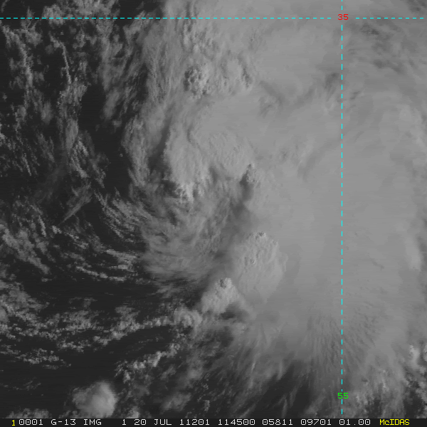
Bret looks much better in the lower levels, though this thing is supporting a good amount of convection.
Nevertheless, I'm very dubious it'll have the time to organize with the pace it's moving at and the encompassing shear.
ATL: CINDY - Remnants - Discussion
Moderator: S2k Moderators
-
Hylian Auree

- Tropical Storm

- Posts: 150
- Age: 31
- Joined: Thu Dec 02, 2010 7:01 pm
- Location: Willemstad, Curaçao
- Contact:
-
lester

- S2K Supporter

- Posts: 1305
- Age: 35
- Joined: Sat Aug 27, 2005 5:21 pm
- Location: Washington, DC
- Contact:
Re: ATL: INVEST 99L - Discussion
AN ELONGATED AREA OF LOW PRESSURE LOCATED ABOUT 300 MILES EAST OF
BERMUDA CONTINUES TO PRODUCE DISORGANIZED SHOWERS AND THUNDERSTORMS.
SOME DEVELOPMENT OF THIS SYSTEM IS POSSIBLE DURING THE NEXT DAY OR
SO BEFORE IT REACHES COOLER WATERS. THIS SYSTEM HAS A MEDIUM
CHANCE...30 PERCENT...OF BECOMING A TROPICAL OR SUBTROPICAL CYCLONE
DURING THE NEXT 48 HOURS AS IT MOVES NORTHEASTWARD AT AROUND 20
MPH.
Sent from my ADR6300 using Tapatalk
0 likes

Re: ATL: INVEST 99L - Discussion
Odds increased slightly, interesting. Did it form from the same frontal system that moved offshore as Bret did?
0 likes
- Disclaimer: Posts herein are my amateur opinion only and should not be used for making important decisions. Defer to the NHC, NWS, and local authorities for official guidance.

Yeah it appears they came from the same frontal system...
0 likes
Personal Forecast Disclaimer:
The posts in this forum are NOT official forecast and should not be used as such. They are just the opinion of the poster and may or may not be backed by sound meteorological data. They are NOT endorsed by any professional institution or storm2k.org. For official information, please refer to the NHC and NWS products
The posts in this forum are NOT official forecast and should not be used as such. They are just the opinion of the poster and may or may not be backed by sound meteorological data. They are NOT endorsed by any professional institution or storm2k.org. For official information, please refer to the NHC and NWS products
-
HURAKAN

- Professional-Met

- Posts: 46086
- Age: 37
- Joined: Thu May 20, 2004 4:34 pm
- Location: Key West, FL
- Contact:
SATELLITE IMAGES THIS MORNING INDICATE THAT SHOWER ACTIVITY
ASSOCIATED WITH A LOW PRESSURE AREA ABOUT 440 MILES EAST OF BERMUDA
HAS BECOME BETTER ORGANIZED. ADDITIONAL DEVELOPMENT OF THIS SYSTEM
IS POSSIBLE DURING THE NEXT DAY OR SO BEFORE IT REACHES COOLER
WATERS. THIS SYSTEM HAS A HIGH CHANCE...60 PERCENT...OF BECOMING A
SUBTROPICAL OR TROPICAL CYCLONE DURING THE NEXT 48 HOURS AS IT
MOVES NORTHEASTWARD AT AROUND 20 MPH.
CODE RED
Last edited by HURAKAN on Wed Jul 20, 2011 6:47 am, edited 1 time in total.
0 likes

-
Florida1118
- Category 5

- Posts: 1805
- Age: 27
- Joined: Sat Jun 19, 2010 12:57 pm
- Location: Tampa, Florida
Re: ATL: INVEST 99L - Discussion
I dont think its going to make it into Cindy/TD3. Its going to run out of time, like a system did last year.
0 likes
Re: ATL: INVEST 99L - Discussion
Could we be seeing Cindy today?
0 likes
"People might not get all they work for in this world, but they must certainly work for all they get."- Frederick Douglass


-
Florida1118
- Category 5
- Posts: 1805
- Age: 27
- Joined: Sat Jun 19, 2010 12:57 pm
- Location: Tampa, Florida
Re: ATL: INVEST 99L - Discussion
0 likes


Re: ATL: INVEST 99L - Discussion
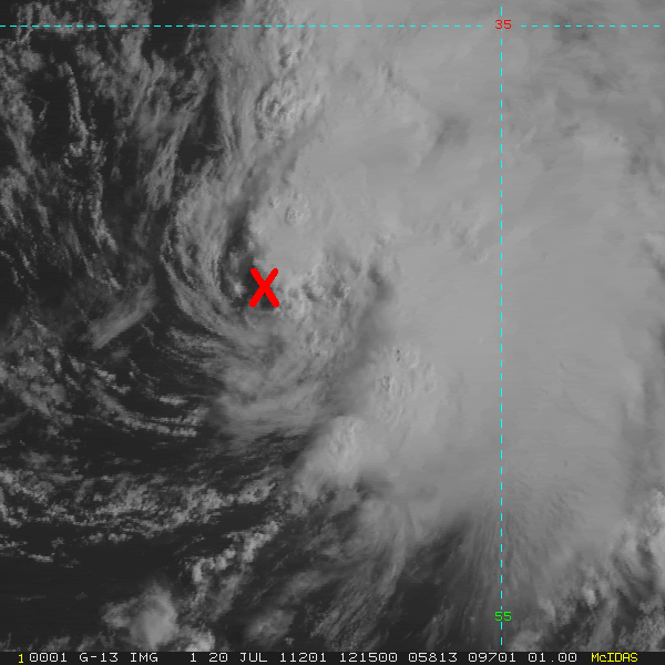
Yeah, it seems that it has a well defined LLC, and convection is not over but is near the center, may be upgraded to a TD and if an ASCAT pass or another tool shows TS force winds it will be Cindy. Let's wait and see.
0 likes
Re: ATL: INVEST 99L - Discussion
Florida1118 wrote::uarrow: The TWO didnt sound like they were going to upgrade soon, but who knows...
Amazing how their tone & mood is different when it does not pose any threat to land areas.
0 likes
For the curious, the most northerly tropical cyclone formation was that of Alberto in 1988 at 41.5 degrees north. A large portion of the NHC's "formation possible" area is north of 41.5 N.
So there's a possible record-breaker out there.
So there's a possible record-breaker out there.
0 likes
Eyes: Emily '86, Dean '89, Felix '95, Gert '99, Fabian '03, Humberto '19, Paulette '20
-
HURAKAN
- Professional-Met
- Posts: 46086
- Age: 37
- Joined: Thu May 20, 2004 4:34 pm
- Location: Key West, FL
- Contact:
WHXX01 KWBC 201248
CHGHUR
TROPICAL CYCLONE GUIDANCE MESSAGE
NWS NATIONAL HURRICANE CENTER MIAMI FL
1248 UTC WED JUL 20 2011
DISCLAIMER...NUMERICAL MODELS ARE SUBJECT TO LARGE ERRORS.
PLEASE REFER TO NHC OFFICIAL FORECASTS FOR TROPICAL CYCLONE
AND SUBTROPICAL CYCLONE INFORMATION.
ATLANTIC OBJECTIVE AIDS FOR
DISTURBANCE INVEST (AL992011) 20110720 1200 UTC
...00 HRS... ...12 HRS... ...24 HRS. .. ...36 HRS...
110720 1200 110721 0000 110721 1200 110722 0000
LAT LON LAT LON LAT LON LAT LON
BAMS 33.3N 56.9W 34.8N 54.4W 36.3N 51.5W 37.8N 47.9W
BAMD 33.3N 56.9W 35.1N 52.7W 37.6N 48.7W 39.8N 43.9W
BAMM 33.3N 56.9W 35.0N 53.9W 37.1N 50.6W 39.0N 46.4W
LBAR 33.3N 56.9W 34.6N 52.9W 36.8N 49.2W 39.6N 45.9W
SHIP 30KTS 38KTS 45KTS 47KTS
DSHP 30KTS 38KTS 45KTS 47KTS
...48 HRS... ...72 HRS... ...96 HRS. .. ..120 HRS...
110722 1200 110723 1200 110724 1200 110725 1200
LAT LON LAT LON LAT LON LAT LON
BAMS 38.7N 44.4W 41.1N 38.0W 44.3N 30.6W 45.8N 23.9W
BAMD 40.7N 39.5W 41.1N 34.5W 42.0N 32.8W 44.9N 30.4W
BAMM 40.0N 42.2W 42.3N 35.4W 45.0N 28.1W 45.3N 22.8W
LBAR 41.8N 42.2W 48.6N 31.5W .0N .0W .0N .0W
SHIP 46KTS 33KTS 0KTS 0KTS
DSHP 46KTS 33KTS 0KTS 0KTS
...INITIAL CONDITIONS...
LATCUR = 33.3N LONCUR = 56.9W DIRCUR = 85DEG SPDCUR = 22KT
LATM12 = 33.1N LONM12 = 61.8W DIRM12 = 90DEG SPDM12 = 18KT
LATM24 = 33.4N LONM24 = 65.5W
WNDCUR = 30KT RMAXWD = 45NM WNDM12 = 25KT
CENPRS = 1010MB OUTPRS = 1015MB OUTRAD = 100NM SDEPTH = M
RD34NE = 0NM RD34SE = 0NM RD34SW = 0NM RD34NW = 0NM
$$
NNNN
0 likes
Who is online
Users browsing this forum: No registered users and 17 guests