ATL: TROPICAL DEPRESSION HENRI (10L)

Moderator: S2k Moderators

Message
Author
Aric Dunn
Category 5
Category 5
Posts: 21228
Age: 41
Joined: Sun Sep 19, 2004 9:58 pm
Location: Ready for the Chase.
Contact:

Re: ATL: TROPICAL STORM HENRI (10L)

#421 Postby Aric Dunn » Wed Oct 07, 2009 2:35 pm

Rainband wrote:Good news 8-)


they may downgrade but by no means is it dead.. ..

we will probably see a new burst sometime here soon.. and actually the multiple vorts explains why there has not been a burst of convection near the naked swirl and thats because the vort that was under the convection is where all the convergence is.


http://www.ssd.noaa.gov/goes/flt/t1/loop-rgb.html
0 likes   

User avatar
HURAKAN
Professional-Met
Professional-Met
Posts: 46086
Age: 37
Joined: Thu May 20, 2004 4:34 pm
Location: Key West, FL
Contact:

#422 Postby HURAKAN » Wed Oct 07, 2009 2:39 pm

Image

Loop
0 likes   

User avatar
Evil Jeremy
S2K Supporter
S2K Supporter
Posts: 5459
Age: 31
Joined: Mon Apr 10, 2006 2:10 pm
Location: Los Angeles, CA

Re: ATL: TROPICAL STORM HENRI (10L)

#423 Postby Evil Jeremy » Wed Oct 07, 2009 2:41 pm

Should be down to a TD at 5, dead at 11 at this rate unless something drastic happens soon.
0 likes   
Frances 04 / Jeanne 04 / Katrina 05 / Wilma 05 / Fay 08 / Debby 12 / Andrea 13 / Colin 16 / Hermine 16 / Matthew 16 / Irma 17

Aric Dunn
Category 5
Category 5
Posts: 21228
Age: 41
Joined: Sun Sep 19, 2004 9:58 pm
Location: Ready for the Chase.
Contact:

Re: ATL: TROPICAL STORM HENRI (10L)

#424 Postby Aric Dunn » Wed Oct 07, 2009 2:43 pm

Shear is dropping very quickly now that the ULL is weakening and moving ever so slowly wsw to sw... the shear axis is becoming less defined and needs to be watched for it to fade away as the ULL dies .. that would allow for a period of more favorable conditions..

Image
0 likes   

Aric Dunn
Category 5
Category 5
Posts: 21228
Age: 41
Joined: Sun Sep 19, 2004 9:58 pm
Location: Ready for the Chase.
Contact:

Re: ATL: TROPICAL STORM HENRI (10L)

#425 Postby Aric Dunn » Wed Oct 07, 2009 2:44 pm

Evil Jeremy wrote:Should be down to a TD at 5, dead at 11 at this rate unless something drastic happens soon.


hehe convective burst soon a little closer the center.. should occur.. low level clouds are thickening again..
0 likes   

User avatar
tailgater
S2K Supporter
S2K Supporter
Posts: 3339
Joined: Sun Jul 11, 2004 9:13 pm
Location: St. Amant La.

Re: ATL: TROPICAL STORM HENRI (10L)

#426 Postby tailgater » Wed Oct 07, 2009 3:14 pm

Aric Dunn wrote:
cycloneye wrote:Is that the primary circulation or there may be another one under the convection? I ask as I see some inflow towards the convection.


actually thats exactly what it is .. as you can see another vort just got spit out from the convection!! both are rotating around a mean center that is slightly closer to the convection ..


From what I can see on the visible loop that is the only center as of now and seems to be getting a bit more inflow as the day goes on, I'd would expect a refire near the center later this evening.
0 likes   
The following post is NOT an official forecast and should not be used as such. It is just the opinion of the poster and may or may not be backed by sound meteorological data. It is NOT endorsed by any professional institution including storm2k.org For Official Information please refer to the NHC and NWS products.

Cuber
S2K Supporter
S2K Supporter
Posts: 63
Joined: Sun Oct 23, 2005 4:04 pm
Location: Plm Bch Grdns FL

Re: ATL: TROPICAL STORM HENRI (10L)

#427 Postby Cuber » Wed Oct 07, 2009 3:19 pm

Derek Ortt wrote:
wxman57 wrote:KF CP = Kentucky Fried Chicken People? That's just what popped into my head first. Must be lunch time.


LOL


ProMets laughing out loud and admitting to thinking about lunch during tropical storm/cyclone season ??? more evidence of a hum-drum 2009 (but keep your waders and slicker nearby Gusty ... just in case)
0 likes   

User avatar
wxman57
Moderator-Pro Met
Moderator-Pro Met
Posts: 22484
Age: 66
Joined: Sat Jun 21, 2003 8:06 pm
Location: Houston, TX (southwest)

Re: ATL: TROPICAL STORM HENRI (10L)

#428 Postby wxman57 » Wed Oct 07, 2009 3:21 pm

tailgater wrote:
Aric Dunn wrote:
cycloneye wrote:Is that the primary circulation or there may be another one under the convection? I ask as I see some inflow towards the convection.


actually thats exactly what it is .. as you can see another vort just got spit out from the convection!! both are rotating around a mean center that is slightly closer to the convection ..


From what I can see on the visible loop that is the only center as of now and seems to be getting a bit more inflow as the day goes on, I'd would expect a refire near the center later this evening.


Yes, that's the only center but I don't see increasing inflow. Just the opposite, I see it's weakening as it separates farther and farther from the convection in an environment of increasing shear.
0 likes   

User avatar
wxman57
Moderator-Pro Met
Moderator-Pro Met
Posts: 22484
Age: 66
Joined: Sat Jun 21, 2003 8:06 pm
Location: Houston, TX (southwest)

Re: ATL: TROPICAL STORM HENRI (10L)

#429 Postby wxman57 » Wed Oct 07, 2009 3:30 pm

Here's an interesting satellite shot/surface plot. Look at the pressure readings and winds around Henri. Note where the highest pressures on the map are - closer to Henri. Now it could be that the ship south of Henri has a barometer that needs recalibration. Look at the pressure gradient from near the center to just east of the heavier squalls - about zero. So there really doesn't appear to be anything present to produce TS winds. Maybe not even 30kt winds. I can't believe that the central pressure of that small vortex is 1008mb. That great of a pressure gradient (8 millibars across 65 miles) just doesn't fit with the surface obs and wind field.

The observation at the buoy north of the center is very telling, too. Wind is 20 kts blowing AWAY from the center. Can't have development without surface convergence.

Image
0 likes   

User avatar
cycloneye
Admin
Admin
Posts: 139309
Age: 67
Joined: Thu Oct 10, 2002 10:54 am
Location: San Juan, Puerto Rico

Re: ATL: TROPICAL STORM HENRI - Advisories

#430 Postby cycloneye » Wed Oct 07, 2009 3:35 pm


000
WTNT35 KNHC 072032
TCPAT5
BULLETIN
TROPICAL STORM HENRI ADVISORY NUMBER 5
NWS TPC/NATIONAL HURRICANE CENTER MIAMI FL AL102009
500 PM AST WED OCT 07 2009

...HENRI CONTINUING TO WEAKEN...

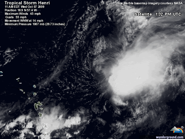
AT 500 PM AST...2100 UTC...THE CENTER OF TROPICAL STORM HENRI WAS
LOCATED NEAR LATITUDE 19.4 NORTH...LONGITUDE 58.6 WEST OR ABOUT
305 MILES...490 KM...EAST-NORTHEAST OF THE NORTHERN LEEWARD ISLANDS.

HENRI IS MOVING TOWARD THE WEST-NORTHWEST NEAR 15 MPH...24 KM/HR...
AND A TURN TOWARD THE WEST WITH A DECREASE IN FORWARD SPEED IS
EXPECTED TOMORROW.

MAXIMUM SUSTAINED WINDS HAVE DECREASED TO NEAR 40 MPH...65 KM/HR...
WITH HIGHER GUSTS. ADDITIONAL WEAKENING IS FORECAST AND HENRI
COULD DISSIPATE BY THURSDAY.

TROPICAL STORM FORCE WINDS EXTEND OUTWARD UP TO 105 MILES...165 KM
FROM THE CENTER.

THE ESTIMATED MINIMUM CENTRAL PRESSURE IS 1008 MB...29.77 INCHES.

...SUMMARY OF 500 PM AST INFORMATION...
LOCATION...19.4N 58.6W
MAXIMUM SUSTAINED WINDS...40 MPH
PRESENT MOVEMENT...WEST-NORTHWEST OR 290 DEGREES AT 15 MPH
MINIMUM CENTRAL PRESSURE...1008 MB

THE NEXT ADVISORY WILL BE ISSUED BY THE NATIONAL HURRICANE CENTER AT
1100 PM AST.

$$
FORECASTER BLAKE

000
WTNT45 KNHC 072032
TCDAT5
TROPICAL STORM HENRI DISCUSSION NUMBER 5
NWS TPC/NATIONAL HURRICANE CENTER MIAMI FL AL102009
500 PM AST WED OCT 07 2009

HENRI IS WEAKENING THIS AFTERNOON WITH THE LOW-LEVEL CENTER MOVING
EVEN FARTHER AWAY FROM A PERSISTENT AREA OF STRONG CONVECTION. THE
LOW-LEVEL CIRCULATION ALSO IS BECOMING LESS WELL-DEFINED WITH A
SECONDARY CENTER NOTED ON RECENT VISIBLE IMAGES. A BLEND OF THE
TAFB/SAB DVORAK ESTIMATES GIVEN AN INITIAL WIND SPEED OF 35 KT...
BUT THIS COULD BE A LITTLE GENEROUS. STRONG WEST TO SOUTHWEST
SHEAR IS LIKELY FOR A DAY OR SO...WHICH WILL CONTINUE TO WEAKEN THE
CYCLONE. IF HENRI SURVIVES THAT SHEAR...AN UPPER-TROUGH AXIS WITH
CONFLUENT FLOW ALOFT SHOULD PROVIDE THE KNOCKOUT BLOW TO THE
TROPICAL CYCLONE. THE OFFICIAL FORECAST IS BASICALLY AN UPDATE TO
THE PREVIOUS ONE...SHOWING DISSIPATION WITHIN 24 HOURS. HOWEVER...
IF DEEP CONVECTION DOES NOT RETURN NEAR THE CENTER...THIS SYSTEM
COULD BECOME A REMNANT LOW SOONER THAN INDICATED BELOW.

USING A MEAN MOTION OF THE TWO CENTERS...THE INITIAL MOTION IS
290/12. A WEST-NORTHWEST PATH IS PROBABLE FOR THE NEXT DAY OR SO
BEFORE RIDGING BUILDS OVER THE WESTERN ATLANTIC. THIS RIDGE SHOULD
CAUSE HENRI...OR THE REMNANTS THEREOF...TO TURN WESTWARD OR EVEN
SOUTH OF WEST UNTIL THE LOW DISSIPATES. THIS SOLUTION HAS GOOD
SUPPORT FROM MODEL GUIDANCE...AND THE OFFICIAL FORECAST IS CLOSE TO
THE PREVIOUS ONE...REMAINING ON THE SOUTHERN SIDE OF THE GUIDANCE
ENVELOPE NEAR BAM SHALLOW.


FORECAST POSITIONS AND MAX WINDS

INITIAL 07/2100Z 19.4N 58.6W 35 KT
12HR VT 08/0600Z 20.1N 60.3W 30 KT
24HR VT 08/1800Z 20.9N 62.0W 25 KT...REMNANT LOW
36HR VT 09/0600Z 21.2N 63.6W 20 KT...REMNANT LOW
48HR VT 09/1800Z 21.0N 66.0W 20 KT...REMNANT LOW
72HR VT 10/1800Z...DISSIPATED

$$
FORECASTER BLAKE

0 likes   
Visit the Caribbean-Central America Weather Thread where you can find at first post web cams,radars
and observations from Caribbean basin members Click Here

User avatar
gatorcane
S2K Supporter
S2K Supporter
Posts: 23499
Age: 46
Joined: Sun Mar 13, 2005 3:54 pm
Location: Boca Raton, FL

#431 Postby gatorcane » Wed Oct 07, 2009 3:36 pm

Looks like we have to watch the wave SE of Henri now also. That is looking very impressive and is Caribbean-bound.

viewtopic.php?f=31&t=106794

Henri really hanging in there still (unfortunately).
Last edited by gatorcane on Wed Oct 07, 2009 3:38 pm, edited 1 time in total.
0 likes   

User avatar
wxman57
Moderator-Pro Met
Moderator-Pro Met
Posts: 22484
Age: 66
Joined: Sat Jun 21, 2003 8:06 pm
Location: Houston, TX (southwest)

Re: ATL: TROPICAL STORM HENRI (10L)

#432 Postby wxman57 » Wed Oct 07, 2009 3:38 pm

I'm not seeing a "second center" the NHC mentions in the advisory. Maybe I'm not holding my head right. Is it about 50-60 miles NNE of the main vortex? If that's what they're looking at, well, I don't know about that. It's racing away from the convection, too. Can't believe they just won't admit that Henri's not a TS. There is no evidence to support TS strength.
0 likes   

Sanibel
Category 5
Category 5
Posts: 10348
Joined: Mon Aug 30, 2004 11:06 pm
Location: Offshore SW Florida

Re: ATL: TROPICAL STORM HENRI (10L)

#433 Postby Sanibel » Wed Oct 07, 2009 3:43 pm

Those pressures must have sinking air. So there's some sort of mystery synoptic shear out there not only shearing the storms off center but drying them out as well with sick air.


As I've already posted with the numerous other systems like this already this year, we have to watch for the one that beats conditions and forms further west. So far, none have.


(God save my porch screens)
0 likes   

User avatar
HURAKAN
Professional-Met
Professional-Met
Posts: 46086
Age: 37
Joined: Thu May 20, 2004 4:34 pm
Location: Key West, FL
Contact:

#434 Postby HURAKAN » Wed Oct 07, 2009 4:11 pm

AL, 10, 2009100600, , BEST, 0, 151N, 492W, 30, 1008, TD, 0, , 0, 0, 0, 0, 1012, 150, 30, 0, 0, L, 0, , 0, 0, INVEST, M,
AL, 10, 2009100606, , BEST, 0, 159N, 505W, 35, 1007, TS, 34, NEQ, 45, 0, 0, 0,
AL, 10, 2009100612, , BEST, 0, 169N, 518W, 35, 1007, TS, 34, NEQ, 45, 0, 0, 0, 1012, 120, 45, 0, 0, L, 0, , 0, 0, INVEST, M,
AL, 10, 2009100618, , BEST, 0, 177N, 534W, 35, 1007, TS, 34, NEQ, 45, 0, 0, 0, 1012, 120, 45, 45, 0, L, 0, , 0, 0, HENRI, M,
AL, 10, 2009100700, , BEST, 0, 179N, 546W, 40, 1006, TS, 34, NEQ, 60, 0, 0, 0, 1012, 150, 45, 45, 0, L, 0, , 0, 0, HENRI, M, 12, NEQ, 45, 0, 0, 0
AL, 10, 2009100706, , BEST, 0, 181N, 556W, 45, 1005, TS, 34, NEQ, 60, 20, 0, 0, 1012, 150, 45, 55, 0, L, 0, , 0, 0, HENRI, M, 12, NEQ, 120, 0, 0, 0
AL, 10, 2009100712, , BEST, 0, 186N, 566W, 45, 1007, TS, 34, NEQ, 60, 60, 0, 0, 1014, 150, 45, 55, 0, L, 0, , 0, 0, HENRI, M, 12, NEQ, 180, 0, 0, 90
AL, 10, 2009100718, , BEST, 0, 191N, 578W, 40, 1008, TS, 34, NEQ, 60, 90, 0, 0, 1012, 135, 30, 0, 0, L, 0, , 0,


In the best track it appears now that Henri became a tropical depression on Oct 6 at 00z.

Image

Track
0 likes   

Aric Dunn
Category 5
Category 5
Posts: 21228
Age: 41
Joined: Sun Sep 19, 2004 9:58 pm
Location: Ready for the Chase.
Contact:

Re: ATL: TROPICAL STORM HENRI (10L)

#435 Postby Aric Dunn » Wed Oct 07, 2009 4:13 pm

wxman57 wrote:I'm not seeing a "second center" the NHC mentions in the advisory. Maybe I'm not holding my head right. Is it about 50-60 miles NNE of the main vortex? If that's what they're looking at, well, I don't know about that. It's racing away from the convection, too. Can't believe they just won't admit that Henri's not a TS. There is no evidence to support TS strength.


The problem is is that although you dont see any evidence of TS force winds does not mean that they dont have other sources ..
0 likes   

User avatar
HURAKAN
Professional-Met
Professional-Met
Posts: 46086
Age: 37
Joined: Thu May 20, 2004 4:34 pm
Location: Key West, FL
Contact:

Re:

#436 Postby HURAKAN » Wed Oct 07, 2009 4:15 pm

HURAKAN wrote:Image

Latest


It was already a tropical depression when I posted this image.
0 likes   

Aric Dunn
Category 5
Category 5
Posts: 21228
Age: 41
Joined: Sun Sep 19, 2004 9:58 pm
Location: Ready for the Chase.
Contact:

Re: ATL: TROPICAL STORM HENRI (10L)

#437 Postby Aric Dunn » Wed Oct 07, 2009 4:15 pm

wxman57 wrote:Here's an interesting satellite shot/surface plot. Look at the pressure readings and winds around Henri. Note where the highest pressures on the map are - closer to Henri. Now it could be that the ship south of Henri has a barometer that needs recalibration. Look at the pressure gradient from near the center to just east of the heavier squalls - about zero. So there really doesn't appear to be anything present to produce TS winds. Maybe not even 30kt winds. I can't believe that the central pressure of that small vortex is 1008mb. That great of a pressure gradient (8 millibars across 65 miles) just doesn't fit with the surface obs and wind field.

The observation at the buoy north of the center is very telling, too. Wind is 20 kts blowing AWAY from the center. Can't have development without surface convergence.

Image


Also the flat pressure gradient that you seem to see ( lacking any real surface obs to confirm such a thing) could possibly be the presence of the second vort which would disrupt any uniform gradient causing misleading data.
0 likes   

Aric Dunn
Category 5
Category 5
Posts: 21228
Age: 41
Joined: Sun Sep 19, 2004 9:58 pm
Location: Ready for the Chase.
Contact:

#438 Postby Aric Dunn » Wed Oct 07, 2009 4:17 pm

The overall motion for the last 3 hours has been nearly west .. 270 to 280 maybe.. which should keep it farther south .. and potentially away from the highest shear and sinking air later in the period.

in addition convection should fire very very soon .. the low level cloud deck is thickening more there is some showers starting show just east of the center.
0 likes   

User avatar
fci
S2K Supporter
S2K Supporter
Posts: 3296
Joined: Tue Sep 14, 2004 10:29 am
Location: Lake Worth, FL

Re: ATL: TROPICAL STORM HENRI (10L)

#439 Postby fci » Wed Oct 07, 2009 4:35 pm

wxman57 wrote:I'm not seeing a "second center" the NHC mentions in the advisory. Maybe I'm not holding my head right. Is it about 50-60 miles NNE of the main vortex? If that's what they're looking at, well, I don't know about that. It's racing away from the convection, too. Can't believe they just won't admit that Henri's not a TS. There is no evidence to support TS strength.


Would not be surprised if the 11 PM is the Final Advisory and it is declared a remnant low
0 likes   

Aric Dunn
Category 5
Category 5
Posts: 21228
Age: 41
Joined: Sun Sep 19, 2004 9:58 pm
Location: Ready for the Chase.
Contact:

Re: ATL: TROPICAL STORM HENRI (10L)

#440 Postby Aric Dunn » Wed Oct 07, 2009 4:40 pm

fci wrote:
wxman57 wrote:I'm not seeing a "second center" the NHC mentions in the advisory. Maybe I'm not holding my head right. Is it about 50-60 miles NNE of the main vortex? If that's what they're looking at, well, I don't know about that. It's racing away from the convection, too. Can't believe they just won't admit that Henri's not a TS. There is no evidence to support TS strength.


Would not be surprised if the 11 PM is the Final Advisory and it is declared a remnant low


its possible in no convection re fires ///
0 likes   


Return to “2009”

Who is online

Users browsing this forum: No registered users and 32 guests