#424 Postby cycloneye » Tue Oct 13, 2009 9:13 pm
WTPN33 PGTW 140300
MSGID/GENADMIN/NAVMARFCSTCEN PEARL HARBOR HI/JTWC//
SUBJ/TROPICAL CYCLONE WARNING//
RMKS/
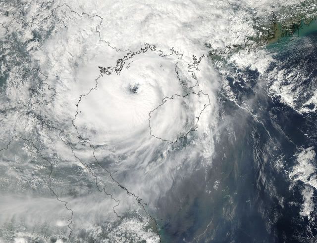
1. TROPICAL STORM 19W (PARMA) WARNING NR 066
02 ACTIVE TROPICAL CYCLONE IN NORTHWESTPAC
MAX SUSTAINED WINDS BASED ON ONE-MINUTE AVERAGE
WIND RADII VALID OVER OPEN WATER ONLY
---
WARNING POSITION:
140000Z --- NEAR 20.5N 107.2E
MOVEMENT PAST SIX HOURS - 290 DEGREES AT 03 KTS
POSITION ACCURATE TO WITHIN 060 NM
POSITION BASED ON CENTER LOCATED BY SATELLITE
PRESENT WIND DISTRIBUTION:
MAX SUSTAINED WINDS - 050 KT, GUSTS 065 KT
WIND RADII VALID OVER OPEN WATER ONLY
RADIUS OF 034 KT WINDS - 060 NM NORTHEAST QUADRANT
050 NM SOUTHEAST QUADRANT
050 NM SOUTHWEST QUADRANT
035 NM NORTHWEST QUADRANT
REPEAT POSIT: 20.5N 107.2E
---
FORECASTS:
12 HRS, VALID AT:
141200Z --- 20.7N 106.6E
MAX SUSTAINED WINDS - 040 KT, GUSTS 050 KT
WIND RADII VALID OVER OPEN WATER ONLY
DISSIPATING AS A SIGNIFICANT TROPICAL CYCLONE OVER LAND
VECTOR TO 24 HR POSIT: 285 DEG/ 03 KTS
---
24 HRS, VALID AT:
150000Z --- 20.9N 105.9E
MAX SUSTAINED WINDS - 020 KT, GUSTS 030 KT
WIND RADII VALID OVER OPEN WATER ONLY
DISSIPATED AS A SIGNIFICANT TROPICAL CYCLONE OVER LAND
---
REMARKS:
140300Z POSITION NEAR 20.6N 107.1E.
TROPICAL STORM (TS) 19W (PARMA), LOCATED APPROXIMATELY 80 NM EAST-
SOUTHEAST OF HANOI, VIETNAM, HAS TRACKED WEST-NORTHWESTWARD AT 03
KNOTS OVER THE PAST SIX HOURS. MAXIMUM SIGNIFICANT WAVE HEIGHT AT
140000Z IS 11 FEET. NEXT WARNINGS AT 140900Z, 141500Z AND 142100Z.
//
NNNN
0 likes
Visit the Caribbean-Central America Weather Thread where you can find at first post web cams,radars
and observations from Caribbean basin members
Click Here