Coral Sea: HAMISH - Tropical Cyclone

Moderator: S2k Moderators

Message
Author
Grifforzer
Category 1
Category 1
Posts: 418
Joined: Thu Feb 26, 2009 11:27 pm

Re:

#181 Postby Grifforzer » Mon Mar 09, 2009 3:56 pm

Chacor wrote:Out of curiosity, where are you getting these advisories from? Becuase I'm not seeing anything on the BoM website with those exact words or in that format.


I am combining the High Sea Warning, Tropical Cyclone Technical Bulletin, and Tropical Cyclone Advices into one post.
0 likes   

Rod Hagen
Tropical Storm
Tropical Storm
Posts: 237
Joined: Fri Sep 23, 2005 6:22 am
Location: Lives in Melbourne, works in N Queensland

#182 Postby Rod Hagen » Mon Mar 09, 2009 4:44 pm

The argument from the Australian BoM , as expressed on the ABC (Australian) news a short while ago , is that :

Earlier, forecaster Bruce Gunn said a jet stream wind would slow the cyclone down overnight.
"It's running into an upper jet stream that wants to rip the top off the cyclone and push it out to the east," he said.
"But the high in the Tasman with the easterly flow is trying to push the lower half of the cyclone back towards the coast.


Hence the conflict with the US Navy model.

Even a cat 2 hitting the coast in this region would do a lot of damage if they are right, I'm afraid.

Here is the latest mean sea level pressure chart:

Image

Cheers

Rod
0 likes   

User avatar
HURAKAN
Professional-Met
Professional-Met
Posts: 46086
Age: 37
Joined: Thu May 20, 2004 4:34 pm
Location: Key West, FL
Contact:

#183 Postby HURAKAN » Mon Mar 09, 2009 5:13 pm

TROPICAL CYCLONE ADVICE NUMBER 36
Issued by the Bureau of Meteorology, Brisbane
Issued at 7:47am on Tuesday the 10th of March 2009

A Cyclone WARNING is current for northern parts of Fraser Island. A Cyclone
WATCH is current for the mainland coast and offshore islands from Yeppoon to
Tewantin [including Heron Island and Lady Elliot Island].

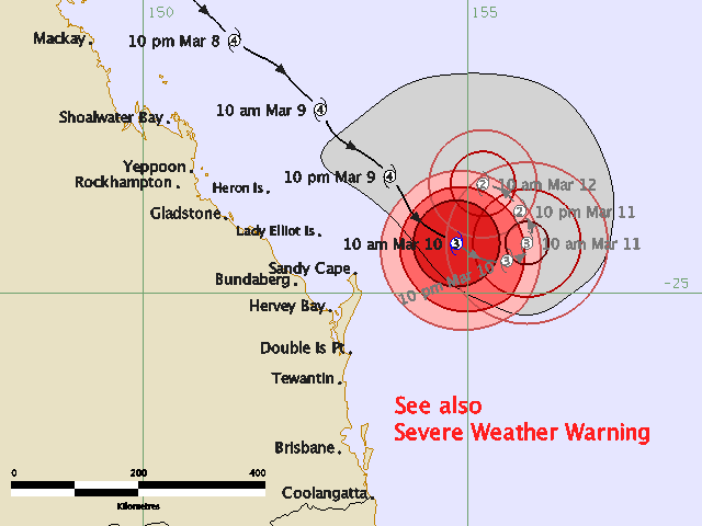
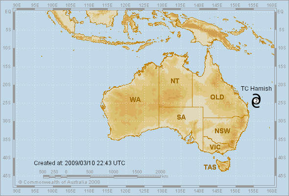
Severe Tropical Cyclone Hamish, a CATEGORY 4 CYCLONE, is located off the
Capricornia coast and at 7:00 am EST was estimated to be 320 kilometres east of
Gladstone and 140 kilometres northeast of Sandy Cape, moving southeast at 11
kilometres per hour.

Severe Tropical Cyclone Hamish is expected to slow down and weaken during today.
It is then forecast to change direction during Wednesday and move west towards
the coast as a weaker cyclone.

Damaging winds are expected to continue to affect the northern part of Fraser
Island during the next few hours.

Damaging winds are not expected to develop about the mainland coast and offshore
islands between Yeppoon and Tewantin during the next 24 hours, however they may
develop later.

Large waves generated by the cyclone may produce elevated sea levels and minor
flooding along the foreshore south of Sandy Cape. People living in areas likely
to be affected by this flooding should take measures to protect their property
as much as possible and be prepared to help their neighbours.

Details of Severe Tropical Cyclone Hamish at 7:00 am EST:
.Centre located near...... 24.0 degrees South 154.4 degrees East
.Location accuracy........ within 19 kilometres
.Recent movement.......... towards the southeast at 11 kilometres per hour
.Wind gusts near centre... 230 kilometres per hour
.Severity category........ 4
.Central pressure......... 950 hectoPascals

People on the northern part of Fraser Island should stay calm and remain in a
secure shelter while the damaging winds continue.

People on the mainland coast between Yeppoon and Tewantin should consider what
action they will need to take if the cyclone threat increases. If you are unsure
about the actions to be taken, information is available from your local
government or local State Emergency Service.

The next advice will be issued by 11:00 am EST Tuesday 10 March.


This warning is also available through TV and Radio Broadcasts; the Bureau's
website at http://www.bom.gov.au or call 1300 659 212. The Bureau and the State
Emergency Service would appreciate this warning being broadcast regularly.
0 likes   

User avatar
HURAKAN
Professional-Met
Professional-Met
Posts: 46086
Age: 37
Joined: Thu May 20, 2004 4:34 pm
Location: Key West, FL
Contact:

Re: Coral Sea: HAMISH - Severe Tropical Cyclone

#184 Postby HURAKAN » Mon Mar 09, 2009 8:06 pm

TROPICAL CYCLONE ADVICE NUMBER 37
Issued by the Bureau of Meteorology, Brisbane
Issued at 11:02am on Tuesday the 10th of March 2009

The Cyclone WATCH from Yeppoon to Tewantin has been cancelled.
The Cyclone WARNING for northern parts of Fraser Island has been cancelled.

Severe Tropical Cyclone Hamish, a CATEGORY 3 CYCLONE, is located off Fraser
Island and at 10:00 am EST was estimated to be 365 kilometres east of Gladstone
and 165 kilometres east northeast of Sandy Cape, moving southeast at 11
kilometres per hour.

Severe Tropical Cyclone Hamish is expected to slow down and gradually weaken.

A separate Severe Weather Warning has been issued for Damaging Winds, Abnormally
High Tides and Dangerous Surf for coastal and island communities between Sandy
Cape and Coolangatta. People living in areas likely to be affected by these
conditions should take measures to protect their property as much as possible
and be prepared to help their neighbours.

Details of Severe Tropical Cyclone Hamish at 10:00 am EST:
.Centre located near...... 24.2 degrees South 154.8 degrees East
.Location accuracy........ within 19 kilometres
.Recent movement.......... towards the southeast at 11 kilometres per hour
.Wind gusts near centre... 220 kilometres per hour
.Severity category........ 3
.Central pressure......... 965 hectoPascals


No further Advices will be issued for this system unless it moves back towards
the coast. Tropical Cyclone Information Bulletins will be issued from 2pm.


This warning is also available through TV and Radio Broadcasts; the Bureau's
website at http://www.bom.gov.au or call 1300 659 212. The Bureau and the State
Emergency Service would appreciate this warning being broadcast regularly.
0 likes   

User avatar
HURAKAN
Professional-Met
Professional-Met
Posts: 46086
Age: 37
Joined: Thu May 20, 2004 4:34 pm
Location: Key West, FL
Contact:

#185 Postby HURAKAN » Mon Mar 09, 2009 8:07 pm

Image

Lets change the route.
0 likes   

User avatar
HURAKAN
Professional-Met
Professional-Met
Posts: 46086
Age: 37
Joined: Thu May 20, 2004 4:34 pm
Location: Key West, FL
Contact:

#186 Postby HURAKAN » Mon Mar 09, 2009 8:35 pm

Image
0 likes   

User avatar
Ptarmigan
Category 5
Category 5
Posts: 5273
Joined: Wed Aug 16, 2006 9:06 pm

Re: Coral Sea: HAMISH - Severe Tropical Cyclone

#187 Postby Ptarmigan » Mon Mar 09, 2009 10:00 pm

Looks like Australia dodged another bullet. Hamish looks like it is going annular.
0 likes   

Rod Hagen
Tropical Storm
Tropical Storm
Posts: 237
Joined: Fri Sep 23, 2005 6:22 am
Location: Lives in Melbourne, works in N Queensland

#188 Postby Rod Hagen » Tue Mar 10, 2009 4:13 am

The JTWC/US Navy projections are now also starting to show an "about face" from Hamish, with a 180º turn instead of progression to the SE, bringing them much closer to the Australian BoM predictions.

Both the US Navy site and the BoM have regularly overestimated the extent of weakening so far and underestimated the drift to the east in most of their postings (not surprising, I would suggest, given the rarity of cyclones of such substantial size in this area in recent decades - there isn't much history to base the models on).

It is hard to see it maintaining strength after the turn, but this cyclone has so far been behaving well outside the expectations almost all the way along, and it is still a 3, capable of doing a lot of harm to this bit of the Queensland coast if it arrives there, even in diminished state.

Maybe I'm a tad on the nervous side at present. ( I Iive about 5 kms from the path of the fires NE of Melbourne that killed over 200 people including quite a few I know personally in our little hunk of the world on Feb 7th and my office is in the little hamlet of St Andrews where 22 people died), but I'd like to see this one get well and truly out of sight before being sure that the bullet has been well and truly dodged in Queensland. Ironically perhaps I know a lot of people in this bit of Queensland too, and I've been to too many funerals already in the last month.

But yes. It is looking better than I feared so far.

Rod

(Weather! Hmph! Can't live with it - can't live without it! )
0 likes   

User avatar
Pedro Fernández
Tropical Storm
Tropical Storm
Posts: 233
Age: 46
Joined: Mon Dec 31, 2007 7:24 am
Location: Costa Tropical (Granada, Spain).
Contact:

#189 Postby Pedro Fernández » Tue Mar 10, 2009 6:45 am

Do you think if a re-intensification is possible? Windshear is around 30-40 KT right now ... Too much to allow to the cyclone to maintain its structure. Nevertheless, sea surface temperature is around 27ºC in the area. Perhaps if HAMISH go out from that unfavorable area maintaining some organization, it could restrengthen again.

Saludos desde España :sun:
0 likes   

User avatar
KWT
Category 5
Category 5
Posts: 31391
Joined: Tue Aug 17, 2004 11:02 am
Location: UK!!!

#190 Postby KWT » Tue Mar 10, 2009 6:56 am

Yep Rod its held its strength longer then forecasted so far, though it does seem to be very slowly weakening still.
0 likes   

User avatar
HURAKAN
Professional-Met
Professional-Met
Posts: 46086
Age: 37
Joined: Thu May 20, 2004 4:34 pm
Location: Key West, FL
Contact:

#191 Postby HURAKAN » Tue Mar 10, 2009 8:01 am

Image

Good times are over for Hamish.
0 likes   

User avatar
HURAKAN
Professional-Met
Professional-Met
Posts: 46086
Age: 37
Joined: Thu May 20, 2004 4:34 pm
Location: Key West, FL
Contact:

#192 Postby HURAKAN » Tue Mar 10, 2009 12:56 pm

Image

Image
0 likes   

User avatar
HURAKAN
Professional-Met
Professional-Met
Posts: 46086
Age: 37
Joined: Thu May 20, 2004 4:34 pm
Location: Key West, FL
Contact:

#193 Postby HURAKAN » Tue Mar 10, 2009 5:47 pm

Image

Severe no more.
0 likes   

User avatar
RattleMan
Category 5
Category 5
Posts: 1218
Joined: Wed Aug 24, 2005 7:14 pm
Location: Phoenix, AZ

Re: Coral Sea: HAMISH - Tropical Cyclone

#194 Postby RattleMan » Tue Mar 10, 2009 5:52 pm

Yikes:

Image
0 likes   

User avatar
Cookie
S2K Supporter
S2K Supporter
Posts: 477
Age: 36
Joined: Sun Dec 14, 2008 11:13 am
Location: Isle Of lewis scotland

#195 Postby Cookie » Tue Mar 10, 2009 5:58 pm

why yikes?
0 likes   

User avatar
HURAKAN
Professional-Met
Professional-Met
Posts: 46086
Age: 37
Joined: Thu May 20, 2004 4:34 pm
Location: Key West, FL
Contact:

#196 Postby HURAKAN » Tue Mar 10, 2009 6:02 pm

Death by shear.

Image
0 likes   

User avatar
Cookie
S2K Supporter
S2K Supporter
Posts: 477
Age: 36
Joined: Sun Dec 14, 2008 11:13 am
Location: Isle Of lewis scotland

#197 Postby Cookie » Tue Mar 10, 2009 6:24 pm

shear dose the hard work so you don't have to....
0 likes   

User avatar
HURAKAN
Professional-Met
Professional-Met
Posts: 46086
Age: 37
Joined: Thu May 20, 2004 4:34 pm
Location: Key West, FL
Contact:

Re: Coral Sea: HAMISH - Tropical Cyclone

#198 Postby HURAKAN » Tue Mar 10, 2009 8:29 pm

Image
0 likes   

User avatar
HURAKAN
Professional-Met
Professional-Met
Posts: 46086
Age: 37
Joined: Thu May 20, 2004 4:34 pm
Location: Key West, FL
Contact:

#199 Postby HURAKAN » Tue Mar 10, 2009 8:45 pm

TROPICAL CYCLONE TECHNICAL BULLETIN: AUSTRALIA - EASTERN REGION
Issued by BRISBANE TROPICAL CYCLONE WARNING CENTRE
at: 0047 UTC 11/03/2009
Name: Tropical Cyclone Hamish
Identifier: 17U
Data At: 0000 UTC
Latitude: 24.3S
Longitude: 155.0E
Location Accuracy: within 15 nm [28 km]
Movement Towards: west northwest [295 deg]
Speed of Movement: 10 knots [18 km/h]
Maximum 10-Minute Wind: 55 knots [100 km/h]
Maximum 3-Second Wind Gust: 75 knots [140 km/h]
Central Pressure: 975 hPa
Radius of 34-knot winds NE quadrant: 50 nm [95 km]
Radius of 34-knot winds SE quadrant: 100 nm [185 km]
Radius of 34-knot winds SW quadrant: 100 nm [185 km]
Radius of 34-knot winds NW quadrant: 70 nm [130 km]
Radius of 48-knot winds NE quadrant: 20 nm [37 km]
Radius of 48-knot winds SE quadrant: 40 nm [75 km]
Radius of 48-knot winds SW quadrant: 40 nm [75 km]
Radius of 48-knot winds NW quadrant: 30 nm [55 km]
Radius of 64-knot winds:
Radius of Maximum Winds: 15 nm [28 km]
Dvorak Intensity Code: T3.5/4.0/W1.5/24HRS
Pressure of outermost isobar: 1008 hPa
Radius of outermost closed isobar: 120 nm [220 km]
Storm Depth: Shallow
FORECAST DATA
Date/Time : Location : Loc. Accuracy: Max Wind : Central Pressure
[UTC] : degrees : nm [km]: knots[km/h]: hPa
+12: 11/1200: 23.6S 154.5E: 045 [085]: 045 [085]: 985
+24: 12/0000: 22.7S 152.9E: 075 [140]: 040 [075]: 992
+36: 12/1200: 22.0S 151.7E: 110 [200]: 030 [055]: 997
+48: 13/0000: 21.4S 151.0E: 140 [260]: 030 [055]: 997
+60: 13/1200: 21.4S 151.1E: 190 [345]: 030 [055]: 997
+72: 14/0000: 21.7S 150.9E: 235 [435]: 030 [055]: 998
REMARKS:
Position good on VIS imagery. Recent NW movement as low level centre is
influenced by the ridge to the south. FT based on MET is 3.5 with W1.5 trend
over 24 hours with high vertical shear. CI held at 4.0.


Copyright Commonwealth of Australia
==
The next bulletin for this system will be issued by: 11/0700 UTC by Brisbane
TCWC.
0 likes   

User avatar
HURAKAN
Professional-Met
Professional-Met
Posts: 46086
Age: 37
Joined: Thu May 20, 2004 4:34 pm
Location: Key West, FL
Contact:

Re: Coral Sea: HAMISH - Tropical Cyclone

#200 Postby HURAKAN » Tue Mar 10, 2009 10:16 pm

Image
0 likes   


Return to “2009”

Who is online

Users browsing this forum: No registered users and 10 guests