WPAC SINLAKU: Severe Tropical Storm - Discussion

Moderator: S2k Moderators

Message
Author
User avatar
jams
Tropical Low
Tropical Low
Posts: 14
Joined: Mon Apr 14, 2008 12:52 pm
Location: Hong Kong
Contact:

Re:

#101 Postby jams » Fri Sep 12, 2008 2:14 pm

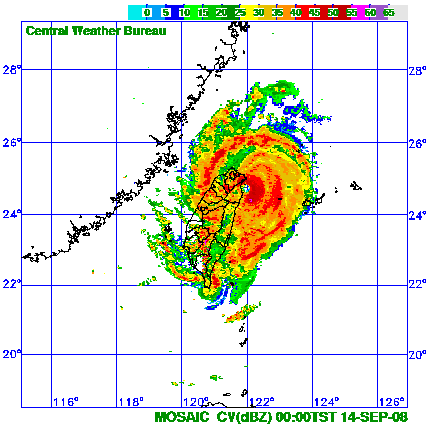
Chacor wrote:38 m/s 975.5 hPa on Yonaguni about a half hour ago.


An update:
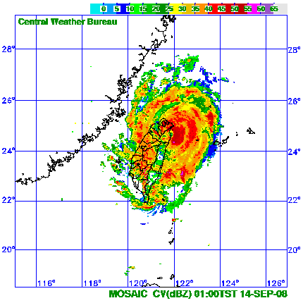
Yonaguni, 38.2 m/s gusting 54.4 m/s at around 0100 JST (1600 UTC).
0 likes   

User avatar
Chacor
Category 5
Category 5
Posts: 10229
Joined: Mon Oct 02, 2006 10:43 pm
Location: Singapore

#102 Postby Chacor » Fri Sep 12, 2008 9:54 pm

WTPQ20 RJTD 130000
RSMC TROPICAL CYCLONE ADVISORY
NAME TY 0813 SINLAKU (0813)
ANALYSIS
PSTN 130000UTC 24.1N 122.7E GOOD
MOVE NW SLOWLY
PRES 945HPA
MXWD 095KT
GUST 135KT
50KT 80NM
30KT 220NM SOUTH 180NM NORTH
FORECAST
24HF 140000UTC 24.8N 122.0E 70NM 70%
MOVE NNW SLOWLY
PRES 950HPA
MXWD 090KT
GUST 130KT
48HF 150000UTC 26.5N 122.2E 160NM 70%
MOVE N SLOWLY
PRES 970HPA
MXWD 065KT
GUST 095KT
72HF 160000UTC 27.8N 124.1E 220NM 70%
MOVE NE SLOWLY
PRES 985HPA
MXWD 055KT
GUST 080KT =
0 likes   

User avatar
Chacor
Category 5
Category 5
Posts: 10229
Joined: Mon Oct 02, 2006 10:43 pm
Location: Singapore

#103 Postby Chacor » Sat Sep 13, 2008 2:27 am

WTPQ20 RJTD 130600
RSMC TROPICAL CYCLONE ADVISORY
NAME TY 0813 SINLAKU (0813)
ANALYSIS
PSTN 130600UTC 24.4N 122.4E GOOD
MOVE NW SLOWLY
PRES 945HPA
MXWD 095KT
GUST 135KT
50KT 90NM
30KT 220NM SOUTH 180NM NORTH
FORECAST
24HF 140600UTC 25.6N 122.0E 70NM 70%
MOVE N SLOWLY
PRES 955HPA
MXWD 085KT
GUST 120KT
48HF 150600UTC 27.2N 123.6E 160NM 70%
MOVE NE SLOWLY
PRES 960HPA
MXWD 075KT
GUST 105KT
72HF 160600UTC 28.8N 127.3E 220NM 70%
MOVE ENE 09KT
PRES 960HPA
MXWD 075KT
GUST 105KT =
0 likes   

Typhoon Hunter
WesternPacificWeather.com
Posts: 1215
Age: 40
Joined: Wed Oct 11, 2006 11:37 am
Location: Hong Kong
Contact:

Re: WPAC SINLAKU: Typhoon - Discussion

#104 Postby Typhoon Hunter » Sat Sep 13, 2008 2:34 am

On location about 10km north of Toucheng (which is 20km north of Ilan ish). CWB radar is brilliant and sat presentation looks much better than it did earlier. It seems to have intensified somewhat. JMA expecting it to blast us overnight and into tomorrow morning. I'm expecting about 18 hours in the eyewall/eye so it's shaping up to be a spectacular event.

Ilan currently recording pressure of 988.7hPa and my Kestrel is currently reading 987.5 so it's not too far off (i'm about 1m above sea level!)
0 likes   

User avatar
HURAKAN
Professional-Met
Professional-Met
Posts: 46086
Age: 37
Joined: Thu May 20, 2004 4:34 pm
Location: Key West, FL
Contact:

#105 Postby HURAKAN » Sat Sep 13, 2008 2:52 am

Image

TH, stay safe and thanks for the updates!
0 likes   

User avatar
HURAKAN
Professional-Met
Professional-Met
Posts: 46086
Age: 37
Joined: Thu May 20, 2004 4:34 pm
Location: Key West, FL
Contact:

#106 Postby HURAKAN » Sat Sep 13, 2008 2:54 am

Image
0 likes   

fasterdisaster
Category 5
Category 5
Posts: 1868
Joined: Mon Sep 19, 2005 4:41 pm
Location: Miami, Florida

#107 Postby fasterdisaster » Sat Sep 13, 2008 3:49 am

Does it look like his eye will miss Taiwan? Not that it won't still cause damage with the NW and SW eyewalls, but the full brunt will stay over water?
0 likes   

User avatar
Harry Cane
Tropical Low
Tropical Low
Posts: 33
Joined: Tue Aug 21, 2007 11:23 pm
Location: Asia
Contact:

#108 Postby Harry Cane » Sat Sep 13, 2008 4:22 am

James are you intercepting this one?
0 likes   

Typhoon Hunter
WesternPacificWeather.com
Posts: 1215
Age: 40
Joined: Wed Oct 11, 2006 11:37 am
Location: Hong Kong
Contact:

Re: WPAC SINLAKU: Typhoon - Discussion

#109 Postby Typhoon Hunter » Sat Sep 13, 2008 4:40 am

I sure am Harry.

Starting to get wavey here.

Image

Image
0 likes   

User avatar
Harry Cane
Tropical Low
Tropical Low
Posts: 33
Joined: Tue Aug 21, 2007 11:23 pm
Location: Asia
Contact:

Re: WPAC SINLAKU: Typhoon - Discussion

#110 Postby Harry Cane » Sat Sep 13, 2008 5:01 am

Looks like it's exploding. Pin hole eye. Mean and nasty.
Is Simone helping you track this monster?
0 likes   

User avatar
Chacor
Category 5
Category 5
Posts: 10229
Joined: Mon Oct 02, 2006 10:43 pm
Location: Singapore

#111 Postby Chacor » Sat Sep 13, 2008 5:26 am

With respect, this is not much of a pinhole eye.

Image
Image

Granted, it is much smaller than what it was a few hours ago.
0 likes   

User avatar
Chacor
Category 5
Category 5
Posts: 10229
Joined: Mon Oct 02, 2006 10:43 pm
Location: Singapore

#112 Postby Chacor » Sat Sep 13, 2008 7:59 am

WTPQ20 RJTD 131200
RSMC TROPICAL CYCLONE ADVISORY
NAME TY 0813 SINLAKU (0813)
ANALYSIS
PSTN 131200UTC 24.5N 122.4E GOOD
MOVE ALMOST STATIONARY
PRES 945HPA
MXWD 095KT
GUST 135KT
50KT 90NM
30KT 240NM SOUTH 180NM NORTH
FORECAST
24HF 141200UTC 26.2N 122.1E 85NM 70%
MOVE NNE SLOWLY
PRES 955HPA
MXWD 085KT
GUST 120KT
48HF 151200UTC 27.7N 124.2E 160NM 70%
MOVE NE 06KT
PRES 960HPA
MXWD 075KT
GUST 105KT
72HF 161200UTC 29.1N 128.0E 220NM 70%
MOVE ENE 09KT
PRES 960HPA
MXWD 075KT
GUST 105KT =
0 likes   

Typhoon Hunter
WesternPacificWeather.com
Posts: 1215
Age: 40
Joined: Wed Oct 11, 2006 11:37 am
Location: Hong Kong
Contact:

Re: WPAC SINLAKU: Typhoon - Discussion

#113 Postby Typhoon Hunter » Sat Sep 13, 2008 9:23 am

Kicking off majorly now.....moving off to cover the show!
0 likes   

User avatar
jams
Tropical Low
Tropical Low
Posts: 14
Joined: Mon Apr 14, 2008 12:52 pm
Location: Hong Kong
Contact:

Re: WPAC SINLAKU: Typhoon - Discussion

#114 Postby jams » Sat Sep 13, 2008 11:03 am

Image

1540Z radar from Central Weater Bureau


Very likely to make landfall on Ilan
0 likes   

User avatar
HURAKAN
Professional-Met
Professional-Met
Posts: 46086
Age: 37
Joined: Thu May 20, 2004 4:34 pm
Location: Key West, FL
Contact:

#115 Postby HURAKAN » Sat Sep 13, 2008 11:33 am

Image

Image

Very close to landfall.
0 likes   

User avatar
HURAKAN
Professional-Met
Professional-Met
Posts: 46086
Age: 37
Joined: Thu May 20, 2004 4:34 pm
Location: Key West, FL
Contact:

#116 Postby HURAKAN » Sat Sep 13, 2008 12:23 pm

Image

Looks like landfall has occurred.
0 likes   

User avatar
HURAKAN
Professional-Met
Professional-Met
Posts: 46086
Age: 37
Joined: Thu May 20, 2004 4:34 pm
Location: Key West, FL
Contact:

#117 Postby HURAKAN » Sat Sep 13, 2008 12:54 pm

Image
0 likes   

User avatar
P.K.
Professional-Met
Professional-Met
Posts: 5149
Joined: Thu Sep 23, 2004 5:57 pm
Location: Watford, England
Contact:

Re: WPAC SINLAKU: Typhoon - Discussion

#118 Postby P.K. » Sat Sep 13, 2008 12:56 pm

I've just spoken to Typhoon Hunter. He is in the eyewall and as you would expect it sounds pretty noisy there with the wind and rain. He says they have found a good place to observe the eye moving onshore.
0 likes   

User avatar
jams
Tropical Low
Tropical Low
Posts: 14
Joined: Mon Apr 14, 2008 12:52 pm
Location: Hong Kong
Contact:

Re: WPAC SINLAKU: Typhoon - Discussion

#119 Postby jams » Sat Sep 13, 2008 1:05 pm

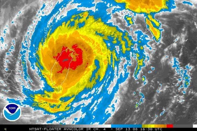
P.K. wrote:I've just spoken to Typhoon Hunter. He is in the eyewall and as you would expect it sounds pretty noisy there with the wind and rain. He says they have found a good place to observe the eye moving onshore.


Radar animation hints that the eye went onshore near Wujie/Zhuangwei at around 1740Z, Toucheng (Typhoon Hunter's current location??) should be under the northern eyewall now...

Do you have the readings from him?
0 likes   

User avatar
P.K.
Professional-Met
Professional-Met
Posts: 5149
Joined: Thu Sep 23, 2004 5:57 pm
Location: Watford, England
Contact:

Re: WPAC SINLAKU: Typhoon - Discussion

#120 Postby P.K. » Sat Sep 13, 2008 1:18 pm

I believe he had moved a bit NE of that position but it has jumped west recently so he will be in the northern eyewall. No readings from him.
0 likes   


Return to “2008”

Who is online

Users browsing this forum: No registered users and 26 guests