ATL: IKE Discussion

Moderator: S2k Moderators

Message
Author
User avatar
HURAKAN
Professional-Met
Professional-Met
Posts: 46086
Age: 37
Joined: Thu May 20, 2004 4:34 pm
Location: Key West, FL
Contact:

Re: ATL: Invest 97L in Eastern Atlantic

#61 Postby HURAKAN » Sun Aug 31, 2008 12:42 pm

Image

TCFA please!! :D

Now we may be needing it.
0 likes   

User avatar
captain east
Tropical Storm
Tropical Storm
Posts: 213
Joined: Thu Aug 28, 2008 2:53 pm
Location: South East Florida

Re: ATL: Invest 97L in Eastern Atlantic

#62 Postby captain east » Sun Aug 31, 2008 12:44 pm

HURAKAN wrote:Image

TCFA please!! :D

Now we may be needing it.

That looks really good for a tropical wave...
0 likes   

User avatar
Bane
Category 2
Category 2
Posts: 690
Joined: Wed Sep 17, 2003 3:06 pm
Location: Ogden, NC
Contact:

#63 Postby Bane » Sun Aug 31, 2008 12:45 pm

it definitely looks to be close to a depression.
0 likes   

User avatar
HURAKAN
Professional-Met
Professional-Met
Posts: 46086
Age: 37
Joined: Thu May 20, 2004 4:34 pm
Location: Key West, FL
Contact:

#64 Postby HURAKAN » Sun Aug 31, 2008 12:47 pm

Image

It even looks good in IR.
0 likes   

User avatar
KWT
Category 5
Category 5
Posts: 31391
Joined: Tue Aug 17, 2004 11:02 am
Location: UK!!!

#65 Postby KWT » Sun Aug 31, 2008 12:50 pm

I actually don't think it looks as good as it did about 36hrs ago however I think it may not be all that far from being a depression either now but there is little to no convection down where any LLC is according to the Qscat.
0 likes   

User avatar
HURAKAN
Professional-Met
Professional-Met
Posts: 46086
Age: 37
Joined: Thu May 20, 2004 4:34 pm
Location: Key West, FL
Contact:

#66 Postby HURAKAN » Sun Aug 31, 2008 1:04 pm

111
ABNT20 KNHC 311756
TWOAT
TROPICAL WEATHER OUTLOOK
NWS TPC/NATIONAL HURRICANE CENTER MIAMI FL
200 PM EDT SUN AUG 31 2008

FOR THE NORTH ATLANTIC...CARIBBEAN SEA AND THE GULF OF MEXICO...

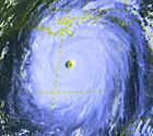
THE NATIONAL HURRICANE CENTER IS ISSUING ADVISORIES ON EXTREMELY
DANGEROUS HURRICANE GUSTAV...LOCATED OVER THE SOUTHEASTERN GULF OF
MEXICO ABOUT 270 MILES SOUTHEAST OF THE MOUTH OF THE MISSISSIPPI
RIVER...AND ON TROPICAL STORM HANNA...LOCATED ABOUT 140 MILES
NORTH OF GRAND TURK ISLAND.

SHOWERS AND THUNDERSTORMS HAVE DIMINISHED TODAY IN ASSOCIATION WITH
A WEAK AREA OF LOW PRESSURE LOCATED ABOUT 825 MILES EAST-NORTHEAST
OF THE LEEWARD ISLANDS. UPPER-LEVEL WINDS ARE ANTICIPATED TO
REMAIN UNFAVORABLE FOR DEVELOPMENT DURING THE NEXT COUPLE OF DAYS.

:rarrow: SHOWER AND THUNDERSTORM ACTIVITY HAVE CHANGED LITTLE TODAY IN
ASSOCIATION WITH A BROAD AREA OF LOW PRESSURE LOCATED ABOUT 625
MILES WEST OF THE CAPE VERDE ISLANDS. HOWEVER...CONDITIONS APPEAR
TO BE CONDUCIVE FOR DEVELOPMENT AND A TROPICAL DEPRESSION COULD
FORM DURING THE NEXT DAY OR TWO AS THIS SYSTEM MOVES WESTWARD AT 10
TO 15 MPH.

ELSEWHERE...TROPICAL CYCLONE FORMATION IS NOT EXPECTED DURING THE
NEXT 48 HOURS.

$$
FORECASTER LANDSEA/BEVEN
0 likes   

User avatar
HURAKAN
Professional-Met
Professional-Met
Posts: 46086
Age: 37
Joined: Thu May 20, 2004 4:34 pm
Location: Key West, FL
Contact:

#67 Postby HURAKAN » Sun Aug 31, 2008 1:06 pm

Dissecting the information:

TROPICAL WEATHER DISCUSSION
NWS TPC/NATIONAL HURRICANE CENTER MIAMI FL
205 PM EDT SUN AUG 31 2008

A TROPICAL WAVE IS ALONG 31W/32W S OF 21N WITH A 1010 MB SURFACE
LOW ALONG THE WAVE AXIS NEAR 16N. AN EARLIER QSCAT PASS CLEARLY
SHOWED THE CYCLONIC CIRCULATION ASSOCIATED WITH THIS SYSTEM WITH
THE STRONGEST WINDS ON THE N SEMICIRCLE. SHOWER AND TSTMS
ACTIVITY HAS INCREASED WITH A CLUSTER OF MODERATE CONVECTION
COVERING THE AREA FROM 18N-20N BETWEEN 31.5W-34W.
CONDITIONS
APPEAR TO BE CONDUCIVE FOR DEVELOPMENT AND A TROPICAL DEPRESSION
COULD FORM DURING THE NEXT DAY OR TWO AS THIS SYSTEM MOVES
WESTWARD AT 10 TO 15 KT.
0 likes   

User avatar
KWT
Category 5
Category 5
Posts: 31391
Joined: Tue Aug 17, 2004 11:02 am
Location: UK!!!

#68 Postby KWT » Sun Aug 31, 2008 1:08 pm

I think any LLC that does try to form will more likely have to relocate further north near the deep convection, if it doesn't don't expect any quick formation.
0 likes   

RL3AO
Moderator-Pro Met
Moderator-Pro Met
Posts: 16308
Joined: Thu Jun 14, 2007 10:03 pm
Location: NC

Re:

#69 Postby RL3AO » Sun Aug 31, 2008 1:17 pm

KWT wrote:I think any LLC that does try to form will more likely have to relocate further north near the deep convection, if it doesn't don't expect any quick formation.


It already has a clear LLC.

Image
0 likes   

User avatar
KWT
Category 5
Category 5
Posts: 31391
Joined: Tue Aug 17, 2004 11:02 am
Location: UK!!!

#70 Postby KWT » Sun Aug 31, 2008 1:26 pm

Ah yeah my bad RL3AO I've just looked at the loop and it looks like its got a tight LLC. I agree we do need a TCFA.

Convection still not at all impressive around that circulation however.
0 likes   

User avatar
cycloneye
Admin
Admin
Posts: 139327
Age: 67
Joined: Thu Oct 10, 2002 10:54 am
Location: San Juan, Puerto Rico

Re: ATL: Invest 97L in Eastern Atlantic

#71 Postby cycloneye » Sun Aug 31, 2008 1:47 pm

The 18:00 UTC Best Track has a 1 mb lower pressure than this morning.

AL, 97, 2008083118, , BEST, 0, 160N, 340W, 30, 1006, DB
0 likes   

User avatar
KWT
Category 5
Category 5
Posts: 31391
Joined: Tue Aug 17, 2004 11:02 am
Location: UK!!!

#72 Postby KWT » Sun Aug 31, 2008 1:49 pm

Looks like the LLC has taken something of a WSW dive just recently (last 2-3hrs from around 16.3N to 16.0N)
0 likes   

User avatar
HURAKAN
Professional-Met
Professional-Met
Posts: 46086
Age: 37
Joined: Thu May 20, 2004 4:34 pm
Location: Key West, FL
Contact:

#73 Postby HURAKAN » Sun Aug 31, 2008 4:10 pm

Image

If convection is able to increase by tomorrow morning like it did today, then we may have TD #9.
0 likes   

User avatar
KWT
Category 5
Category 5
Posts: 31391
Joined: Tue Aug 17, 2004 11:02 am
Location: UK!!!

#74 Postby KWT » Sun Aug 31, 2008 4:15 pm

Yep I agree Hurakan we just need convection now and then we will be off to the races, the LLC looks evident enough for now.
0 likes   

bob rulz
Category 5
Category 5
Posts: 1667
Age: 34
Joined: Sat Jan 28, 2006 7:30 pm
Location: Salt Lake City, Utah

#75 Postby bob rulz » Sun Aug 31, 2008 4:30 pm

TD by 5pm tomorrow?
0 likes   

User avatar
HURAKAN
Professional-Met
Professional-Met
Posts: 46086
Age: 37
Joined: Thu May 20, 2004 4:34 pm
Location: Key West, FL
Contact:

Re:

#76 Postby HURAKAN » Sun Aug 31, 2008 4:31 pm

bob rulz wrote:TD by 5pm tomorrow?


It will depend on the convection.
0 likes   

User avatar
BigA
Professional-Met
Professional-Met
Posts: 1317
Joined: Sun Jul 24, 2005 10:56 pm

Re: ATL: Invest 97L in Eastern Atlantic

#77 Postby BigA » Sun Aug 31, 2008 4:44 pm

Seems to me that a new llc is forming/has formed near 18 north, near the bulk of the deeper convection. Looks apparent on last visible images of day.
0 likes   

User avatar
HURAKAN
Professional-Met
Professional-Met
Posts: 46086
Age: 37
Joined: Thu May 20, 2004 4:34 pm
Location: Key West, FL
Contact:

#78 Postby HURAKAN » Sun Aug 31, 2008 4:44 pm

Loop: http://rammb.cira.colostate.edu/product ... 291300.GIF

In the loop the circulation is evident and you see the development of a great northern outflow.
0 likes   

User avatar
Matt-hurricanewatcher
Category 5
Category 5
Posts: 11649
Age: 38
Joined: Fri Nov 26, 2004 11:09 pm
Location: Portland,OR
Contact:

Re: ATL: Invest 97L in Eastern Atlantic

#79 Postby Matt-hurricanewatcher » Sun Aug 31, 2008 5:03 pm

Looks like a depression to me. I expect Advisorys by 11pm.
0 likes   

User avatar
KWT
Category 5
Category 5
Posts: 31391
Joined: Tue Aug 17, 2004 11:02 am
Location: UK!!!

#80 Postby KWT » Sun Aug 31, 2008 5:05 pm

Yeah I've got to admit it does look like a tropical depression but I wouldn't count on it, the NHC has been practically wanting systems on the verge of TS strength this year so far!
0 likes   


Return to “2008”

Who is online

Users browsing this forum: No registered users and 5 guests