ATL: Tropical Storm Bertha RECON Discussion

Moderator: S2k Moderators

Message
Author
CrazyC83
Professional-Met
Professional-Met
Posts: 33398
Joined: Tue Mar 07, 2006 11:57 pm
Location: Deep South, for the first time!

Re:

#61 Postby CrazyC83 » Fri Jul 11, 2008 12:28 pm

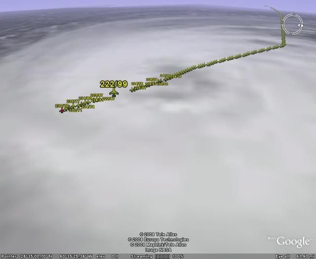
Chacor wrote:92 kts flight-level. 85% reduction = 78 kts


I thought it is a 90% reduction at 700mb? 92 kt would translate to 83 kt at that level (supports 80 kt intensity).
Last edited by CrazyC83 on Fri Jul 11, 2008 12:29 pm, edited 1 time in total.
0 likes   

User avatar
KWT
Category 5
Category 5
Posts: 31391
Joined: Tue Aug 17, 2004 11:02 am
Location: UK!!!

#62 Postby KWT » Fri Jul 11, 2008 12:29 pm

Yep supports 80kts however surface estimates are only in the 65kts sort of range, depends on what you believe I suppose is more likely!
0 likes   

User avatar
Matt-hurricanewatcher
Category 5
Category 5
Posts: 11649
Age: 38
Joined: Fri Nov 26, 2004 11:09 pm
Location: Portland,OR
Contact:

Re:

#63 Postby Matt-hurricanewatcher » Fri Jul 11, 2008 12:30 pm

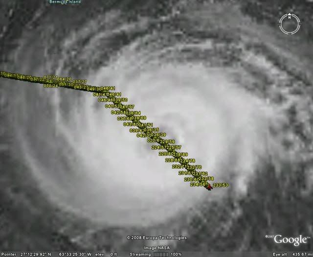
KWT wrote:Looks like it has a central pressure of 975.9mbs according to recon, so about 976mbs then!


Look like my guest what not bad. Lets see if we find some 80-85 knot surface winds.
0 likes   

CrazyC83
Professional-Met
Professional-Met
Posts: 33398
Joined: Tue Mar 07, 2006 11:57 pm
Location: Deep South, for the first time!

Re:

#64 Postby CrazyC83 » Fri Jul 11, 2008 12:30 pm

KWT wrote:Yep supports 80kts however surface estimates are only in the 65kts sort of range, depends on what you believe I suppose is more likely!


What is that column between the direction/winds and the SFMR?
0 likes   

User avatar
KWT
Category 5
Category 5
Posts: 31391
Joined: Tue Aug 17, 2004 11:02 am
Location: UK!!!

#65 Postby KWT » Fri Jul 11, 2008 12:32 pm

Temps and dew points I believe?

Matt, what I've seen supports 80kts, not sure about 85kts mind you just yet we need to see those surface estimates increase but we do still have to sample the strongest quadrant typically, the NE side.
0 likes   

User avatar
Thunder44
Category 5
Category 5
Posts: 5922
Age: 43
Joined: Mon Jun 09, 2003 7:53 pm
Location: New York City

Re: ATL: Hurricane Bertha RECON Discussion

#66 Postby Thunder44 » Fri Jul 11, 2008 12:32 pm

Max FL Wind they found so far in SE Eyewall was 99kts. They are flying around 3000 meters. So reduction is 90%. Surface winds would be 89kts. Cat 2.

Although SFMR reports don't support this upgrade yet.
0 likes   

User avatar
HURAKAN
Professional-Met
Professional-Met
Posts: 46086
Age: 37
Joined: Thu May 20, 2004 4:34 pm
Location: Key West, FL
Contact:

#67 Postby HURAKAN » Fri Jul 11, 2008 12:35 pm

Image
0 likes   

User avatar
Chacor
Category 5
Category 5
Posts: 10229
Joined: Mon Oct 02, 2006 10:43 pm
Location: Singapore

#68 Postby Chacor » Fri Jul 11, 2008 12:36 pm

171700 2820N 06135W 6969 03041 9958 +069 +050 222092 099 066 010 00

222092 and 099, what's the difference? Both are FL winds, right?
0 likes   

RL3AO
Moderator-Pro Met
Moderator-Pro Met
Posts: 16308
Joined: Thu Jun 14, 2007 10:03 pm
Location: NC

Re:

#69 Postby RL3AO » Fri Jul 11, 2008 12:36 pm

Chacor wrote:171700 2820N 06135W 6969 03041 9958 +069 +050 222092 099 066 010 00

222092 and 099, what's the difference? Both are FL winds, right?


92 = 30 sec avg
99 = 10 sec gust
0 likes   

User avatar
KWT
Category 5
Category 5
Posts: 31391
Joined: Tue Aug 17, 2004 11:02 am
Location: UK!!!

#70 Postby KWT » Fri Jul 11, 2008 12:37 pm

Also that 99kts was only for a 10 second sample, the 30 second smaple was at 92kts which is why we are using that for the reduction rather then the 99kts and as you say surface estimates are only around 65-70kts.
0 likes   

CrazyC83
Professional-Met
Professional-Met
Posts: 33398
Joined: Tue Mar 07, 2006 11:57 pm
Location: Deep South, for the first time!

#71 Postby CrazyC83 » Fri Jul 11, 2008 12:38 pm

Here is what we have now (surface estimates):

Flight level - 83 kt (SE quad)
SFMR - 72 kt (NW quad)

That likely will mean holding it at 75 kt for now, although 80 kt is possible.
Last edited by CrazyC83 on Fri Jul 11, 2008 12:42 pm, edited 1 time in total.
0 likes   

User avatar
Matt-hurricanewatcher
Category 5
Category 5
Posts: 11649
Age: 38
Joined: Fri Nov 26, 2004 11:09 pm
Location: Portland,OR
Contact:

Re: ATL: Hurricane Bertha RECON Discussion

#72 Postby Matt-hurricanewatcher » Fri Jul 11, 2008 12:40 pm

Thunder44 wrote:Max FL Wind they found so far in SE Eyewall was 99kts. They are flying around 3000 meters. So reduction is 90%. Surface winds would be 89kts. Cat 2.

Although SFMR reports don't support this upgrade yet.


This suggests that this system has been 5-10 knots stronger then what the nhc has said it was. So it was possible it did reach cat3 during its second peak...
0 likes   

User avatar
HURAKAN
Professional-Met
Professional-Met
Posts: 46086
Age: 37
Joined: Thu May 20, 2004 4:34 pm
Location: Key West, FL
Contact:

#73 Postby HURAKAN » Fri Jul 11, 2008 12:40 pm

Image

Crazy, they haven't investigated the NE quadrant yet.
0 likes   

CrazyC83
Professional-Met
Professional-Met
Posts: 33398
Joined: Tue Mar 07, 2006 11:57 pm
Location: Deep South, for the first time!

Re:

#74 Postby CrazyC83 » Fri Jul 11, 2008 12:42 pm

HURAKAN wrote:Image

Crazy, they haven't investigated the NE quadrant yet.


OK I corrected the estimates.
0 likes   

User avatar
Thunder44
Category 5
Category 5
Posts: 5922
Age: 43
Joined: Mon Jun 09, 2003 7:53 pm
Location: New York City

Re: ATL: Hurricane Bertha RECON Discussion

#75 Postby Thunder44 » Fri Jul 11, 2008 12:44 pm

Matt-hurricanewatcher wrote:
Thunder44 wrote:Max FL Wind they found so far in SE Eyewall was 99kts. They are flying around 3000 meters. So reduction is 90%. Surface winds would be 89kts. Cat 2.

Although SFMR reports don't support this upgrade yet.


This suggests that this system has been 5-10 knots stronger then what the nhc has said it was. So it was possible it did reach cat3 during its second peak...


That report is also 10 second gust. So I don't know what they are going to do with it.
0 likes   

User avatar
KWT
Category 5
Category 5
Posts: 31391
Joined: Tue Aug 17, 2004 11:02 am
Location: UK!!!

#76 Postby KWT » Fri Jul 11, 2008 12:46 pm

They would go for the longer time sample because NHC uses 1 min sustained winds.
Indeed it would probably be a split between surface estimates and upper winds found, probably would be around 80kts, maybe 85kts if anything higher is found in NE quadrants.
0 likes   

User avatar
Thunder44
Category 5
Category 5
Posts: 5922
Age: 43
Joined: Mon Jun 09, 2003 7:53 pm
Location: New York City

Re: ATL: Hurricane Bertha RECON Discussion

#77 Postby Thunder44 » Fri Jul 11, 2008 12:54 pm

KWT, the 2pm Advisory says Recon reported back a pressure of 977mb. If that's what in the VDM... :wink:
0 likes   

User avatar
KWT
Category 5
Category 5
Posts: 31391
Joined: Tue Aug 17, 2004 11:02 am
Location: UK!!!

#78 Postby KWT » Fri Jul 11, 2008 1:02 pm

Yep 977mbs, a little bit above the estimate but then are just estimates anyway. I just wonder what we will find once recon goes into the NE quadrant of the hurricane?
0 likes   

Derek Ortt

Re:

#79 Postby Derek Ortt » Fri Jul 11, 2008 1:20 pm

KWT wrote:Also that 99kts was only for a 10 second sample, the 30 second smaple was at 92kts which is why we are using that for the reduction rather then the 99kts and as you say surface estimates are only around 65-70kts.


you use the 10-second winds for reduction, not the 30 second
0 likes   

User avatar
KWT
Category 5
Category 5
Posts: 31391
Joined: Tue Aug 17, 2004 11:02 am
Location: UK!!!

#80 Postby KWT » Fri Jul 11, 2008 1:21 pm

Looks like recon is going to make another run at the NE eyewall fairly shortly, this will give us a good indication of Bertha's strength.
0 likes   


Return to “2008”

Who is online

Users browsing this forum: No registered users and 8 guests