ATL SIXTEEN: Tropical Depression - Discussion
Moderator: S2k Moderators


-
Blown Away

- S2K Supporter

- Posts: 9867
- Joined: Wed May 26, 2004 6:17 am
Re: ATL: INVEST 99L - Discussion
I think everbody in the Caribbean needs to keep a close eye on this system. Overnight this went from a sure thing going into CA to lingering around in the NW Caribbean. I think 99L has the potential to be a big problem.
0 likes

Folks,
We better hope the 6z NAM is way off because a lingering developing hurricane over the NW carribean in Mid-October would be very bad news for many.
http://www.nco.ncep.noaa.gov/pmb/nwprod ... loop.shtml
We better hope the 6z NAM is way off because a lingering developing hurricane over the NW carribean in Mid-October would be very bad news for many.
http://www.nco.ncep.noaa.gov/pmb/nwprod ... loop.shtml
0 likes
-
HURAKAN

- Professional-Met

- Posts: 46086
- Age: 37
- Joined: Thu May 20, 2004 4:34 pm
- Location: Key West, FL
- Contact:
TROPICAL WEATHER DISCUSSION
NWS TPC/NATIONAL HURRICANE CENTER MIAMI FL
805 AM EDT TUE OCT 14 2008
TROPICAL WEATHER DISCUSSION FOR NORTH AMERICA...CENTRAL
AMERICA...GULF OF MEXICO...CARIBBEAN SEA...NORTHERN SECTIONS
OF SOUTH AMERICA...AND ATLANTIC OCEAN TO THE AFRICAN COAST
FROM THE EQUATOR TO 32N. THE FOLLOWING INFORMATION IS
BASED ON SATELLITE IMAGERY...METEOROLOGICAL ANALYSIS...
WEATHER OBSERVATIONS...AND RADAR.
BASED ON 0600 UTC SURFACE ANALYSIS AND GOES-12 SATELLITE
IMAGERY THROUGH 0315 UTC...AND METEOSAT-9 IMAGERY THROUGH
14/0530 UTC.
...SPECIAL FEATURES...
A 1006 MB WESTERN CARIBBEAN SEA LOW PRESSURE CENTER IS ABOUT
50 NM TO THE EAST OF NORTHEASTERN NICARAGUA NEAR 14.5N82W.
NUMEROUS STRONG SHOWERS AND THUNDERSTORMS ARE FROM 13N TO 18N
80W AND 86W...TOUCHING PARTS OF EXTREME NORTHEASTERN NICARAGUA
AND EASTERN HONDURAS. THE PRECIPITATION ELSEWHERE TO THE NORTH
OF 17N WEST OF 74W FROM SIX HOURS AGO HAS BECOME ISOLATED OR
COMPLETELY DISSIPATED.
0 likes
-
HURAKAN
- Professional-Met
- Posts: 46086
- Age: 37
- Joined: Thu May 20, 2004 4:34 pm
- Location: Key West, FL
- Contact:
260
ABNT20 KNHC 141156
TWOAT
TROPICAL WEATHER OUTLOOK
NWS TPC/NATIONAL HURRICANE CENTER MIAMI FL
800 AM EDT TUE OCT 14 2008
FOR THE NORTH ATLANTIC...CARIBBEAN SEA AND THE GULF OF MEXICO...
THE NATIONAL HURRICANE CENTER IS ISSUING ADVISORIES ON TROPICAL
DEPRESSION FIFTEEN...LOCATED ABOUT 140 MILES NORTH OF CURACAO AND
ABOUT 360 MILES SOUTHWEST OF SAN JUAN PUERTO RICO. THE FINAL
ADVISORY HAS BEEN ISSUED ON TROPICAL DEPRESSION NANA...LOCATED
ABOUT 1175 MILES EAST OF THE NORTHERN LEEWARD ISLANDS.
 A WELL-DEFINED AREA OF LOW PRESSURE CENTERED OVER THE WESTERN
CARIBBEAN SEA ABOUT 60 MILES NORTHEAST OF THE NICARAGUA-HONDURAS
BORDER IS MOVING SLOWLY TOWARD THE WEST-NORTHWEST. SHOWER AND
THUNDERSTORM ACTIVITY HAS CONTINUED TO INCREASE AND BECOME BETTER
ORGANIZED THIS MORNING...AND A TROPICAL DEPRESSION COULD FORM LATER
TODAY...IF THE SYSTEM REMAINS OVER WATER. AN AIR FORCE RESERVE UNIT
RECONNAISSANCE AIRCRAFT IS SCHEDULED TO INVESTIGATE THE SYSTEM THIS
AFTERNOON TO PROVIDE A BETTER ESTIMATE OF THE ITS STRENGTH.
REGARDLESS OF WHETHER OR NOT THIS SYSTEM BECOMES A TROPICAL
CYCLONE...IT IS LIKELY TO PRODUCE LOCALLY HEAVY RAINS OVER PORTIONS
OF NICARAGUA...HONDURAS...AND BELIZE OVER THE NEXT COUPLE OF DAYS.
A WEAK AREA OF LOW PRESSURE...LOCATED SOUTH-SOUTHEAST OF DISSIPATED
TROPICAL DEPRESSION NANA AND APPROXIMATELY 1125 MILES WEST OF THE
SOUTHERNMOST CAPE VERDE ISLANDS...CONTINUES TO PRODUCE SOME
THUNDERSTORM ACTIVITY MAINLY TO THE EAST OF THE CENTER. THIS SYSTEM
WILL ENCOUNTER UNFAVORABLE UPPER-LEVEL WINDS AS IT MOVES SLOWLY
NORTH-NORTHEASTWARD OVER THE NEXT DAY OR TWO...AND SIGNIFICANT
DEVELOPMENT IS NOT ANTICIPATED.
ELSEWHERE...TROPICAL CYCLONE FORMATION IS NOT EXPECTED DURING THE
NEXT 48 HOURS.
$$
FORECASTER STEWART
ABNT20 KNHC 141156
TWOAT
TROPICAL WEATHER OUTLOOK
NWS TPC/NATIONAL HURRICANE CENTER MIAMI FL
800 AM EDT TUE OCT 14 2008
FOR THE NORTH ATLANTIC...CARIBBEAN SEA AND THE GULF OF MEXICO...
THE NATIONAL HURRICANE CENTER IS ISSUING ADVISORIES ON TROPICAL
DEPRESSION FIFTEEN...LOCATED ABOUT 140 MILES NORTH OF CURACAO AND
ABOUT 360 MILES SOUTHWEST OF SAN JUAN PUERTO RICO. THE FINAL
ADVISORY HAS BEEN ISSUED ON TROPICAL DEPRESSION NANA...LOCATED
ABOUT 1175 MILES EAST OF THE NORTHERN LEEWARD ISLANDS.
CARIBBEAN SEA ABOUT 60 MILES NORTHEAST OF THE NICARAGUA-HONDURAS
BORDER IS MOVING SLOWLY TOWARD THE WEST-NORTHWEST. SHOWER AND
THUNDERSTORM ACTIVITY HAS CONTINUED TO INCREASE AND BECOME BETTER
ORGANIZED THIS MORNING...AND A TROPICAL DEPRESSION COULD FORM LATER
TODAY...IF THE SYSTEM REMAINS OVER WATER. AN AIR FORCE RESERVE UNIT
RECONNAISSANCE AIRCRAFT IS SCHEDULED TO INVESTIGATE THE SYSTEM THIS
AFTERNOON TO PROVIDE A BETTER ESTIMATE OF THE ITS STRENGTH.
REGARDLESS OF WHETHER OR NOT THIS SYSTEM BECOMES A TROPICAL
CYCLONE...IT IS LIKELY TO PRODUCE LOCALLY HEAVY RAINS OVER PORTIONS
OF NICARAGUA...HONDURAS...AND BELIZE OVER THE NEXT COUPLE OF DAYS.
A WEAK AREA OF LOW PRESSURE...LOCATED SOUTH-SOUTHEAST OF DISSIPATED
TROPICAL DEPRESSION NANA AND APPROXIMATELY 1125 MILES WEST OF THE
SOUTHERNMOST CAPE VERDE ISLANDS...CONTINUES TO PRODUCE SOME
THUNDERSTORM ACTIVITY MAINLY TO THE EAST OF THE CENTER. THIS SYSTEM
WILL ENCOUNTER UNFAVORABLE UPPER-LEVEL WINDS AS IT MOVES SLOWLY
NORTH-NORTHEASTWARD OVER THE NEXT DAY OR TWO...AND SIGNIFICANT
DEVELOPMENT IS NOT ANTICIPATED.
ELSEWHERE...TROPICAL CYCLONE FORMATION IS NOT EXPECTED DURING THE
NEXT 48 HOURS.
$$
FORECASTER STEWART
0 likes
-
O Town
- S2K Supporter
- Posts: 5203
- Age: 50
- Joined: Wed Sep 07, 2005 9:37 pm
- Location: Orlando, Florida 28°35'35"N 81°22'55"W
Re:
Vortex wrote:Folks,
We better hope the 6z NAM is way off because a lingering developing hurricane over the NW carribean in Mid-October would be very bad news for many.
http://www.nco.ncep.noaa.gov/pmb/nwprod ... loop.shtml
I pretty sure that is TD15 the NAM is developing not 99L, but still would be bad news none the less.
EDIT: after looking again I believe it IS indeed 99L after if circles over Central America but converges with another low coming in from the east. Alot of the models are now showing this kind of meandering over CA. Definitely needs watching.
0 likes
-
gatorcane

- S2K Supporter
- Posts: 23499
- Age: 46
- Joined: Sun Mar 13, 2005 3:54 pm
- Location: Boca Raton, FL
Re: ATL: INVEST 99L: TWO "TD could form later today"
blown_away wrote: think everbody in the Caribbean needs to keep a close eye on this system. Overnight this went from a sure thing going into CA to lingering around in the NW Caribbean. I think 99L has the potential to be a big problem..
Recall that I was never sold on a Central America solution despite some pretty strong arguments against it. While I DO recognize the presence of a ridge over the GOM and Florida when the Euro is stalling something in the NW Caribbean, one has to take note of it, I'm sorry.
The Euro has been quite a good model as of late and is good at predicting synoptic setups far in advance.
0 likes
-
wxman57

- Moderator-Pro Met

- Posts: 22484
- Age: 66
- Joined: Sat Jun 21, 2003 8:06 pm
- Location: Houston, TX (southwest)
Re: ATL: INVEST 99L: TWO "TD could form later today"
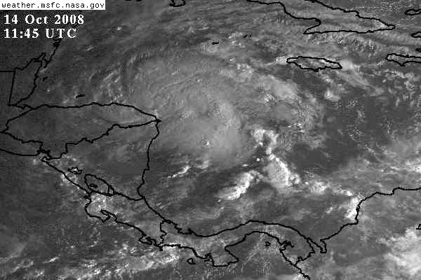
I think it's pretty obvious we have TD 16, if not "Omar" in the western Caribbean now. Surface obs show a well-defined LLC. Satellite indicates good banding and outflow. What else is needed to upgrade it? As for its future, I still think a west track toward Belize then inland is most likely. But I am concerned that more recent model guidance indicates a slower westward movement and perhaps stalling near the coast of Belize. That doesn't mean it would head to Florida, necessarily, but it may be delayed in moving inland.
0 likes

-
HURAKAN
- Professional-Met
- Posts: 46086
- Age: 37
- Joined: Thu May 20, 2004 4:34 pm
- Location: Key West, FL
- Contact:
Code: Select all
361
TCCA23 KNHC 141248
STDWCA

SATELLITE TROPICAL DISTURBANCE RAINFALL ESTIMATES
NWS TPC/NATIONAL HURRICANE CENTER MIAMI FL
1215 UTC TUE OCT 14 2008


SYSTEM NAME/IDENTIFIER...WESTERN CARIBBEAN DISTURBANCE

                                             MAX RAINFALL
  DATE/TIME      LOCATION       MOTION      MEAN      LAST
 -----------   ------------     ------     -------   -------
14/1215 UTC   15.8N 82.8W      330/06     19.7 IN    13.3 IN


LAST RAINFALL DISTRIBUTION...

     DISTANCE          LEFT OF CENTER      RIGHT OF CENTER
   -------------      ---------------      ---------------
   0 TO 1 DEGREE       1.8 TO  3.5 IN       3.7 TO  7.4 IN
   1 TO 2 DEGREE       0.6 TO  2.8 IN       7.3 TO  1.7 IN
   2 TO 3 DEGREE       0.5 TO  5.4 IN       6.3 TO 13.3 IN
   3 TO 4 DEGREE       0.0 TO  4.0 IN       0.5 TO  6.2 IN


                        ...LEGEND...

SYSTEM NAME/IDENTIFIER...NAME OR NUMBER ASSIGNED TO SYSTEM
                         (E.G. TROPICAL STORM ALPHA, TROPICAL
                         DISTURBANCE 01, SURFACE TROUGH)

DATE/TIME...             DAY OF MONTH AND TIME IN UNIVERSAL TIME
                         COORDINATES (UTC) IN A DY/HRMN FORMAT

LOCATION...              ESTIMATED CENTER OF SYSTEM OR ADVISORY
                         POSITION FOR TROPICAL CYCLONE IN TENTHS
                         OF DEGREES OF LATITUDE AND LONGITUDE

MOTION...                ESTIMATED DIRECTION AND SPEED OF SYSTEM
                         IN DEGREES AND KNOTS

MEAN MAXIMUM RAINFALL... THE 24-HOUR MEAN MAXIMUM ACCUMULATION OF
                         RAINFALL FOR THE SYSTEM IN INCHES BASED
                         ON FOUR SATELLITE IMAGES SIX HOURS APART

LAST MAXIMUM RAINFALL... THE MAXIMUM ACCUMULATION OF RAINFALL FOR
                         THE SYSTEM IN INCHES BASED ON THE MOST
                         RECENT SATELLITE IMAGE

RAINFALL DISTRIBUTION... THE DISTRIBUTION OF RAINFALL WITHIN FOUR
                         DEGREES (240 NM) LEFT AND RIGHT OF THE
                         SYSTEM CENTER IN ONE DEGREE (60NM)
                         INCREMENTS...LOOKING DOWNSTREAM
                         (1 IN = 25.4 MM)
0 likes
-
gatorcane
- S2K Supporter
- Posts: 23499
- Age: 46
- Joined: Sun Mar 13, 2005 3:54 pm
- Location: Boca Raton, FL
Re: ATL: INVEST 99L: TWO "TD could form later today"
wxman57 wrote:I think it's pretty obvious we have TD 16, if not "Omar" in the western Caribbean now. Surface obs show a well-defined LLC. Satellite indicates good banding and outflow. What else is needed to upgrade it? As for its future, I still think a west track toward Belize then inland is most likely. But I am concerned that more recent model guidance indicates a slower westward movement and perhaps stalling near the coast of Belize. That doesn't mean it would head to Florida, necessarily, but it may be delayed in moving inland.
Thanks for sharing this concern. We'll have to hope models shove it into Central America before it can really get going.
Although no model brings 99L into Florida looking at the latest guidance, South Floridians know that a lingering system in the NW Caribbean sea in mid October can spell trouble.
I am going to be interested in seeing the NHC track for this one...I suspect they would move 99L WNW over the course of a few days and stall it just over or near Belize then the 4-5 day track would be near stationary.
0 likes
-
sargeabernathy
- Tropical Low

- Posts: 21
- Joined: Sat Sep 29, 2007 5:24 am
Re: ATL: INVEST 99L: TWO "TD could form later today"
TD 16 accordling to the NRL,
http://www.nrlmry.navy.mil/tc_pages/tc_home.html
October certainly is active.
Edit: That link was way too long. Here's a shorter one!
Now, let's see if 15 and 16 can race eachother to the title of Omar!
http://www.nrlmry.navy.mil/tc_pages/tc_home.html
October certainly is active.
Edit: That link was way too long. Here's a shorter one!
Now, let's see if 15 and 16 can race eachother to the title of Omar!
0 likes


-
Ivanhater

- Storm2k Moderator

- Posts: 10852
- Age: 37
- Joined: Fri Jul 01, 2005 8:25 am
- Location: Pensacola
Re: INVEST 99L: invest_RENUMBER_al992008_al162008.ren
David, on Sandys pic, it says sixteen on it, meaning an upgrade at 11
0 likes
-
vbhoutex

- Storm2k Executive

- Posts: 28976
- Age: 72
- Joined: Wed Oct 09, 2002 11:31 pm
- Location: Spring Branch area, Houston, TX
- Contact:
Re:
Chacor wrote:16L.SIXTEEN, vbhoutex...
http://www.nrlmry.navy.mil/TC.html
It wasn't on the link he provided when I looked at it. I have now deleted my post since it is obvious it will be called shortly.
0 likes
-
HURAKAN
- Professional-Met
- Posts: 46086
- Age: 37
- Joined: Thu May 20, 2004 4:34 pm
- Location: Key West, FL
- Contact:
Link to the Best Track of 99L / 16L shortly: ftp://ftp.tpc.ncep.noaa.gov/atcf/tcweb/ ... 008.invest
AL, 16, 2008101412, , BEST, 0, 154N, 828W, 30, 1004, TD
AL, 16, 2008101412, , BEST, 0, 154N, 828W, 30, 1004, TD
0 likes
Who is online
Users browsing this forum: No registered users and 16 guests