
Magnitudes of quakes picking up to near 4.0.
Usually, volcanoes rip at about this level.
http://www.emsc-csem.org/#2
El Hierro, Canary's - Red-Alert, Eruption Underway
Moderator: S2k Moderators
Re: Earthquake activity below El Hierro (volcano), Canary Island
Increases in the last hours the number and intensity of tremors
Two new quakes have been felt by the people this afternoon. A new tremor of 3.8 degrees on the Richter scale was recorded at 15:44 hours according to data from the National Geographic Institute (IGN), at a depth of 17 kilometers southwest of the municipality of Frontera.
Earlier, an earthquake of magnitude 3.5 degrees (according to the latest confirmation of IGN), has felt on the island of El Hierro, at 14:38 hours. The movement was detected at a depth of 17 kilometers suroete Border (correcting the 11 miles south of the municipality of Frontera in the ocean).
This latest move has been the most intense of the 37 registered ranged from 1.5 degrees to 3.8.
Just this morning detected a movement of 3.5 degrees to a depth of 15 kilometers southwest of the town of Frontera.
According to the Facebook profile Current Volcanic Islands (AVCAN) this Tuesday, the recent seismic activity is shifting to the south and east, but have focused primarily on Julan area, the same area from 20 September. Some activity was observed more diffuse towards the southeast.
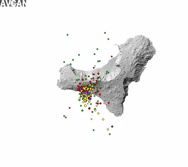
In purple are the five earthquakes greater than or equal to 2.6 of September 27, 2011, which give an idea of where most seismic activity concentrated in the area.

Devil's Ladder, so called to this form of the curve of energy released accumulated on the island of Hierro from the September 19, 2011 until Tuesday September 27. In volcanology is used because its steps are increasingly high, which indicates a volcanic process reactivated. Also called Cantor function is that it has infinite height and width steps variable but follow a pattern.
Meetings with people
This afternoon continue with the public information sessions on the seismic series affecting the island since last July 19 and action in civil protection provided to volcanic risk, with the support of the Government of Canary Island Administration of the State, municipalities of the island and scientists from the National Geographic Institute (IGN) and volcanological Instituto de Canarias (non-tip).
In the municipality of Valverde, reported in the Centro Cultural de San Andrés (at 18:00) and the Casino de Valverde (at 20:00). While the appointments will be held Wednesday at the Centro Cultural de La Caleta (18:00 hours), and the Centro Cultural de El Mocanal (at 20:00).
http://www.diariodeavisos.com/2011/09/2 ... -el-hierro
Two new quakes have been felt by the people this afternoon. A new tremor of 3.8 degrees on the Richter scale was recorded at 15:44 hours according to data from the National Geographic Institute (IGN), at a depth of 17 kilometers southwest of the municipality of Frontera.
Earlier, an earthquake of magnitude 3.5 degrees (according to the latest confirmation of IGN), has felt on the island of El Hierro, at 14:38 hours. The movement was detected at a depth of 17 kilometers suroete Border (correcting the 11 miles south of the municipality of Frontera in the ocean).
This latest move has been the most intense of the 37 registered ranged from 1.5 degrees to 3.8.
Just this morning detected a movement of 3.5 degrees to a depth of 15 kilometers southwest of the town of Frontera.
According to the Facebook profile Current Volcanic Islands (AVCAN) this Tuesday, the recent seismic activity is shifting to the south and east, but have focused primarily on Julan area, the same area from 20 September. Some activity was observed more diffuse towards the southeast.
In purple are the five earthquakes greater than or equal to 2.6 of September 27, 2011, which give an idea of where most seismic activity concentrated in the area.
Devil's Ladder, so called to this form of the curve of energy released accumulated on the island of Hierro from the September 19, 2011 until Tuesday September 27. In volcanology is used because its steps are increasingly high, which indicates a volcanic process reactivated. Also called Cantor function is that it has infinite height and width steps variable but follow a pattern.
Meetings with people
This afternoon continue with the public information sessions on the seismic series affecting the island since last July 19 and action in civil protection provided to volcanic risk, with the support of the Government of Canary Island Administration of the State, municipalities of the island and scientists from the National Geographic Institute (IGN) and volcanological Instituto de Canarias (non-tip).
In the municipality of Valverde, reported in the Centro Cultural de San Andrés (at 18:00) and the Casino de Valverde (at 20:00). While the appointments will be held Wednesday at the Centro Cultural de La Caleta (18:00 hours), and the Centro Cultural de El Mocanal (at 20:00).
http://www.diariodeavisos.com/2011/09/2 ... -el-hierro
0 likes
Re: Earthquake activity below El Hierro (volcano), Canary Island
Las Palmas de Gran Canaria, EFE About 300 people living in several villages in the municipality of La Frontera, on the island of El Hierro, will be evacuated this evening at the risk of occurrence of landslides by seismic is recorded the area have reported government sources canary.
http://www.eldia.es/2011-09-27/ISLAS/17 ... ientos.htm
http://www.eldia.es/2011-09-27/ISLAS/17 ... ientos.htm
0 likes

Re: Earthquake activity below El Hierro (volcano), Canary Island
El Hierro is preparing for a possible evacuation of 4,000 people
Civil Protection has designed a plan to evacuate 4,000 people in case it was necessary in four hours .
This has contacted shipping companies and airlines serving the islands to use their ships in case of eruption.
http://www.libertaddigital.com/sociedad ... 276436523/
Civil Protection has designed a plan to evacuate 4,000 people in case it was necessary in four hours .
This has contacted shipping companies and airlines serving the islands to use their ships in case of eruption.
http://www.libertaddigital.com/sociedad ... 276436523/
0 likes
Re: Earthquake activity below El Hierro (volcano), Canary Island
The government from the Canary Islands and the local El Hierro authorities are "fearing more the potential" earthquake risks than a possible eruption at this point.
Tonight the Cabildo de El Hierro has decided 2 important new precautionary measures :
a) Schools will be closed until further notice as a preventive measure
b) The Los Roquillos tunnel will be closed from 23:00 (11 PM) on and this until further notice.
Los Roquillos Tunnel connects the villages of Valverde and Frontera.
People living in houses in the following communities : Las Puntas; Sabinosa; Pie Risco; Pozo de la Salud y Guinea have been asked to evacuate to community buildings in Frontera.
The government of the Canary Islands makes a new appeal to the population to stay calm and repeats once again that an eruption is not eminent and the the present "semaforo Amarillo" (we call it Yellow Alert) remains UNCHANGED since it was called on Sunday (NO deterioration only an increasing earthquake risk)
The biggest part of the "Nota Informativa" (Informative report) describes what to do during a serious earthquake, of course nothing special for the regular readers of this site. All the text can be described by 3 words : Drop, Cover and Hold
http://earthquake-report.com/2011/09/25 ... to-yellow/
0 likes
Re: Earthquake activity below El Hierro (volcano), Canary Island
Scientists of IGN are expecting activity similar to the October 1971 La Palma eruption.
Canary Island eruptions are generally 'Strombolian', similar to Hawaii and Sicily eruptions.
La Palma October 1971 eruption video – an eventual eruption is expected by scientists to be the same style:
http://earthquake-report.com/2011/09/25 ... to-yellow/
[youtube]http://www.youtube.com/watch?v=MQ-7HwZyOVs&feature=player_embedded[/youtube]
0 likes
Re: Earthquake activity below El Hierro (volcano), Canary Island
Troops of the Military Emergency Unit (UME) in the Canary Islands this afternoon depart by boat from Tenerife to El Hierro to assist in an eventual evacuation of the island to the risk of volcanic eruption and earthquakes that are increasingly more intense. So far, authorities have evacuated some 53 people (the council originally planned 300) and closed the main tunnel of the island, linking the two largest cities. The National Geographic Institute (IGN) is studying whether low iron magma is rising to the surface. The seismometers that the institute has spread throughout the island found at 03.59 in early this morning an earthquake with a magnitude of 2.3 to two kilometers deep, although this is subject to review if it were a mistake measurement. So far most of earthquakes have been recorded at between 12 and 15 kilometers deep.
The rise of the hypocenter is one of the signs of which are very outstanding scientists to see if the magma is rising and, therefore, increasing the possibility of a volcanic eruption. IGN experts, however, emphasize that the data of the two miles deep is inconclusive and that what matters is the general trend. On day 25, two earthquakes occurred five miles deep and day 19, one of three kilometers deep. IGN does not comment on the information that hangs on his website because they are subject to revision.
http://www.01.ign.es/ign/layoutIn/sismo ... ad_dias=10
At six this morning, the Canary Islands government has sent a fax requesting support the Ministry of Defence of the EMU for a possible evacuation. At noon is expected to leave the port of Tenerife a boat with 31 soldiers and 12 vehicles, six trucks, four buses and two mini- reports Natalia Junquera. There is also a campaign shelter for 2,000 people, which was another the requests of the Canarian Government. It is also planned that in the first phase of evacuation, the victims were the barracks of the Armed Anatolio Fuentes.
The seismic crisis of El Hierro rose a notch last night. Around 22.00, the Civil Guard began to warn families of four cores of the municipality of Frontera (north of the island) that they should leave their homes for fear of landslides. The hit came with resignation to the square of the neighborhood. "We caught it right and go to my brother," explained Mari Paz resigned. The evicted residents come from the neighborhoods of Las Puntas, El Lunchón, corks, Foot Risco, Guinea and has not been necessary to evict any resident of Sabinosa and the Well of Health. 38 chose to attend with family and friends and 15 to the dorm Valverde.
The main artery of the island has been cut. Travel between the two main towns, Valverde to Frontera, will last for 15 minutes at 40 by a mountain road. In addition, 500 students (a third of the island) do not have school today.
National Geographic Institute scientists roam the villages of the island to explain what might happen, to calm the people and answer their questions. In addition, Civil Protection of the Canary Islands has developed a device to, at worst, the evacuation of 4,000 people in four hours. He has already contacted shipping companies and airlines that operate in the Canary Islands to use their ships in case of eruption.
Most earthquakes have been imperceptible to the 10,000 inhabitants of El Hierro. Of the more than 8,000 since 19 July, only 15 have sense, but the increasing intensity has raised the alarm. "We can not fight with nature," sums Casañez Arminda Perez, a woman returned to the emigration of Venezuela 40 years ago. Is at the door of his house in the village of Sabina, one of the most affected. Arminda, who wears a medal of Our Lady of Coromoto has hardly noticed the earthquake, but it is informed. He has gone to the talks by scientists from IGN and knows that in case of eruption, go to the town square and should have prepared a bag with essentials. It has not, as most of the respondents, it does not seem to fear that the earth to open beneath his feet. Maite Padrón, director of the Hotel Balneario Pozo de la Salud, has felt the cancellation of visits more than earthquakes.
Evacuations are taking place one step at a rally that began Friday, when the Canaries rose for the first time volcano warning light and put it in amber: pre-emergence. Yesterday there was almost a hundred and reaching a magnitude of 3.8. At least on paper everything is ready. "Do not look at all leave the island, but handle different assumptions," says Juan Manuel Santana, Director General of Security and Emergency Canary Islands Government. IGN has developed several hypotheses about how an eruption can occur and the paths they could follow the lava and ash. "What else is planned is in the Gulf area, which could affect 4,000 people," that "would be evacuated within four hours," said Santana.
On the slope of the Gulf, Abella and Itahiza Rafael Dominguez, IGN researchers, control the situation through sensors across the island to notice the movements that are mild and pass on the fly to Madrid. They came here just to note, in mid-July, an unusual move to deploy land mobile network. "Anything can happen," he admits. Everything is calm or the emergence of a rash on the sea and no one will know until the lava affecting the west of the island. But it can also nothing happens in weeks or years. Nobody knows what happens to the magma, located between 12 and 15 kilometers deep. What is not in doubt, say the GPS is that the island "has swelled about four centimeters," according Itahiza. With the rise of magma, the field expands. Elsewhere on the island, Dácil Nolasco, a researcher at the Institute of Volcanology of the Canary Islands, click on the ground every 500 meters to measure the diffuse flux of CO2, which serves as an indicator of the magmatic activity in the subsoil. Nemesio Perez, non-tip, confirms that the flow of CO2 has risen almost continuously over the last month.
Although from the Volcano Teneguía in 1971, there has been no eruption in the Canary Islands, the population is relatively normal phenomenon. The leaflet handed out to calm the population noted that the archipelago has "similar to Hawaiian volcanism, where people live daily with its active volcanoes" and asks people to "pay no attention to rumors spread alarmist nor" . But the councils have no depth at all. Yesterday, the earth shook as the young Border institute received a lecture on how to stay calm in case of earthquakes. The response was not very quiet, as Ruyman Quintero, 16 third-year student and ESO.
People do not have much experience, because since 1793 there is a similar crisis. Then record the tremors stopped the letters which the Mayor of El Hierro sent to the royal Audiencia de Canarias in the ships calling to evacuate the population for the continuous tremors, as documented by the teacher at the University of La Laguna Carmen Romero . It is believed that then, he says, erupting not over, at least there are no historical records, or if there was not very great. Then came to nothing. This time, we'll see.
http://www.elpais.com/articulo/sociedad ... soc_11/Tes
0 likes
Re: Earthquake activity below El Hierro (volcano), Canary Island
3 documented Slide-Zones that have occurred in the past at El Hierro

Last edited by GCANE on Fri Sep 30, 2011 4:20 am, edited 1 time in total.
0 likes
-
angelwing

- S2K Supporter

- Posts: 4462
- Age: 62
- Joined: Tue Jan 18, 2005 3:06 pm
- Location: Kulpsville, PA
Re: Earthquake activity below El Hierro (volcano), Canary Island
(for what its worth)
RSOE EDIS ALERTMAIL
Situation Update No. 1
Posted:2011-08-24, 07:53:51 [UTC]
Ref.no.: EQ-20110824-32077-SPI
Situation Update No. 1
On 2011-09-28 at 11:12:09 [UTC]
Event: Earthquake
Location: Canary-Islands (Esp.) Province of Las Palmas Agüimes
Situation:
Fears are growing that the El Hierro volcano in The Canary Islands could soon erupt after seismic activity beneath the island increased dramatically during Tuesday and Wednesday. Over 150 earthquakes were recorded on the smallest of the Canary Islands during Tuesday prompting officials to evacuate some local residents, shut El Hierro's main tunnel, and close local schools. At least 20 earthquakes, exceeding magnitude 3.0 on the Richter Scale, have been felt by local residents during the last 24 hours. The most recent earthquake, which measured 3.4 magnitude, was recorded just off the southern tip of the island at 07:04 am Wednesday. The rise in seismic activity last night prompted the Spanish Civil Guard (Guardia Civil) to advise almost 50 residents of the municipality of La Frontera to leave their homes because of landslide fears.
Plans are also underway to evacuate more of the island's 10,000 residents, according to Canarias7.es. The newspaper reported that two units of the Spanish military's emergency intervention unit (EMU) will depart nearby island Tenerife this afternoon to assist in the possible evacuation of hundreds of El Hierro residents. Meanwhile, the island's main tunnel (Tunel del Golfo), which links Frontera to Valverde, has been shut forcing motorists to travel across the 280-sq-km island via a mountain road. The Cabildo de El Hierro also has ordered the closure of schools on Wednesday. Hierro, a shield volcano, has had a single historic eruption from the Volcan de Lomo Negro vent in 1793. The eruption lasted approximately one month and produced lava flows. The Canary Islands Government commenced an in-depth geological survey of El Hierro earlier this month in an effort to determine the source of an earthquake swarm. The Government raised the volcanic risk level to ‘Yellow' on Sunday, the highest alert status since an unprecedented earthquake swarm commenced in mid-July.
The unprecedented seismic activity commenced on 19 July (the activity was first reported by iWeather Online on 26 July). In excess of 8,200 earthquakes have been recorded up to Wednesday, 28 September 2011. Up to last weekend, the majority of earth tremors ranged between 1 and 3 magnitude. However, the majority of quakes are now registering between 2 and 4 magnitude and are occuring at depth of 14-17 kilometres, according to the National Geographic Institute (IGN). Speaking to the El Pais newspaper, volcanologist Juan Carlos Carracedo suggested that an eruption on El Hierro would "not be a major surprise". He explained: "It is the youngest of the Canary Islands. There is a ball of magma which is rising to the surface and it is stationed at the limit of the earth's crust. At the moment we do not know if that ball of magna will break the crust and cause an eruption." IGN Director, María José Blanco said that any eruption on El Hierro would most likely have a "low explosion value". He added that an imminent eruption is unlikely. In the meantime, the frequent and increasingly intense earthquakes being felt throughout El Hierro are unlikely to appease the residents of and visitors to the tiny island.
Earthquake swarms are events where a local area experiences sequences of many earthquakes striking in a relatively short period of time. The length of time used to define the swarm itself varies, but the United States Geological Survey (USGS) points out that an event may last for days, weeks, or months. El Hierro is situated in the most southwestern extreme of the Canaries. The island was formed after three successive eruptions, and consequent accumulations, the island emerged from the ocean as an imposing triangular pyramid crowned by a volcano more than 2,000 metres high.
The volcanic activity, principally at the convergence of the three ridges, resulted in the continual expansion of the island. A mere 50,000 years ago, as a result of seismic tremors which produced massive landslides, a giant piece of the island cracked off, crashed down into the ocean and scattered along the seabed. This landslide of more than 300km3 gave rise to the impressive amphitheatre of the El Golfo valley and at the same time caused a tsunami that most likely rose over 100 metres high and probably reached as far as the American coast.
According to the Global Volcanism Program, the massive Hierro shield volcano is truncated by a large NW-facing escarpment, seen here from the east, which formed as a result of gravitational collapse of the volcano. The steep-sided 1500-m-high scarp towers above a low lava platform bordering 12-km-wide El Golfo Bay, which is barely visible at the extreme left. Holocene cones and flows are found both on the outer flanks and in the El Golfo depression. The last eruption, during the 18th century, produced a lava flow from a cinder cone on the NW side of El Golfo.
According to ElHierro.com: "Although over 200 years have elapsed since the last eruption, El Hierro has the largest number of volcanoes in the Canaries with over 500 open sky cones, another 300 covered by the most recent outflows, and some 70 caves and volcanic galleries, notably the Don Justo cave whose collection of channels surpasses 6km in length." El Hierro is located south of Isla de la Palma (population 86,000), currently the most volcanically active of the Canary Islands. About a half a million years ago, the volcano, Taburiente, collapsed with a giant landslide, forming the Caldera de Taburiente. Since the Spanish occupation, there have been seven eruptions.
0 likes
Re: Earthquake activity below El Hierro (volcano), Canary Island
Longer range El Hierro Quake Plot.
July through September.
Quakes are shown with the island's topology for visual reference.
Two rotations; one flat profile view, one perspective view.
Color denotes the date of quake.
[youtube]http://www.youtube.com/watch?v=WTv8Axvwijs[/youtube]
July through September.
Quakes are shown with the island's topology for visual reference.
Two rotations; one flat profile view, one perspective view.
Color denotes the date of quake.
[youtube]http://www.youtube.com/watch?v=WTv8Axvwijs[/youtube]
0 likes
-
angelwing
- S2K Supporter
- Posts: 4462
- Age: 62
- Joined: Tue Jan 18, 2005 3:06 pm
- Location: Kulpsville, PA
Re: Earthquake activity below El Hierro (volcano), Canary Island
RSOE EDIS ALERTMAIL
Situation Update No. 2
Posted:2011-08-24, 07:53:51 [UTC]
Ref.no.: EQ-20110824-32077-SPI
Situation Update No. 2
On 2011-09-28 at 16:01:41 [UTC]
Event: Earthquake
Location: Canary-Islands (Esp.) Province of Las Palmas Agüimes
Situation:
Police evacuated 53 residents and tourists from houses at the foot of a volcano on Spain's Canary Islands after a recent series of earthquakes, authorities and witnesses said Wednesday. The evacuation on the island of El Hierro aimed to prevent inhabitants being hit by volcanic rock that might be hurled out of the volcano, a municipal official who asked not to be named told AFP. The official added however that authorities did not expect a full-scale "imminent eruption." "We were having some wine yesterday evening when the Civil Guard told us to leave the house because we were too close to the mountain," German holidaymaker Tuengen Maier, 62, told AFP by telephone. "We are just going to pick up our luggage this morning. This is too dangerous. We cannot stay," added Maier, who spent a night in a student residence and aimed to spend the rest of his holiday on nearby Tenerife. The tremors started in July and have been growing in intensity, raising fears among residents that the volcano was about to erupt. The Spanish National Geographic Institute has recorded 8,000 tremors since July 19, most of them too small to be felt, but one recorded overnight on Wednesday reached 3.4 magnitude.
Situation Update No. 2
Posted:2011-08-24, 07:53:51 [UTC]
Ref.no.: EQ-20110824-32077-SPI
Situation Update No. 2
On 2011-09-28 at 16:01:41 [UTC]
Event: Earthquake
Location: Canary-Islands (Esp.) Province of Las Palmas Agüimes
Situation:
Police evacuated 53 residents and tourists from houses at the foot of a volcano on Spain's Canary Islands after a recent series of earthquakes, authorities and witnesses said Wednesday. The evacuation on the island of El Hierro aimed to prevent inhabitants being hit by volcanic rock that might be hurled out of the volcano, a municipal official who asked not to be named told AFP. The official added however that authorities did not expect a full-scale "imminent eruption." "We were having some wine yesterday evening when the Civil Guard told us to leave the house because we were too close to the mountain," German holidaymaker Tuengen Maier, 62, told AFP by telephone. "We are just going to pick up our luggage this morning. This is too dangerous. We cannot stay," added Maier, who spent a night in a student residence and aimed to spend the rest of his holiday on nearby Tenerife. The tremors started in July and have been growing in intensity, raising fears among residents that the volcano was about to erupt. The Spanish National Geographic Institute has recorded 8,000 tremors since July 19, most of them too small to be felt, but one recorded overnight on Wednesday reached 3.4 magnitude.
0 likes
Re: Earthquake activity below El Hierro (volcano), Canary Island
Here is a picture of the cliffs on the west side of the island.
They are about 600 to 900 ft high.

They are about 600 to 900 ft high.
0 likes
Re: Earthquake activity below El Hierro (volcano), Canary Island
Energy release has more than doubled in last 24 hrs.

0 likes
Re: Earthquake activity below El Hierro (volcano), Canary Island
The situation in El Hierro is stabilized and the children return to class
The Canary Islands Government and the Cabildo de El Hierro have decided Wednesday night that the schools of the island on Thursday resume normal activity, in view of recent scientific reports indicate that the scale of earthquakes seems to have slowed and has entered a stationary phase. However, it will remain closed to traffic, risk of landslides, the tunnel that connects the island's capital, Valverde, to the valley of the Gulf (north), the most affected by seismic , as reported by the Director General of Security and Emergency Canarian Government, Juan Manuel Santana. this required to change school bus routes, so that children in the municipality of Frontera Valverde studying in his school reach the summit through of the island. The fifty people on Tuesday were evicted from their homes in the town of Frontera spend another night outside their homes (most are staying with family and only a dozen remain in the dorm Valverde) , but tomorrow it will review your situation and decide whether they can return. This was noted by the President of the Cabildo, Alpidio Armas, who has stressed that the islanders will have to learn to live with the situation presented in El Hierro from mid-July , a period in which the island has been rocked by more than 8,000 low-intensity earthquakes of volcanic origin, most noticeable. "This is a topic that we will have to learn to live, if not stopped. We will have to integrate into our lives, peace and responsibility, "added Armas. Cabildo president has stressed the message of reassurance that all authorities have been saying for days and stressed that the scientific reports indicate that the situation seems to have entered a stationary phase. In the same vein, Santana pointed out that such events are cyclical seismic events caused by the pressure of magma in the subsurface, so that "fall within the normal." In fact, the volcanic risk in light of El Hierro is still located in yellow, in a situation of "pre-alert." The Director General of Security of the Canarian Government has also explained that the latest information available indicates that the focus of the earthquake was is moving south of the island.
http://www.canarias7.es/articulo.cfm?id=231236
0 likes
Re: Earthquake activity below El Hierro (volcano), Canary Island
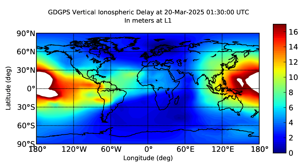
Very strong ionospheric anomaly has been building the last few hours and is heading toward the Canaries.
This is due to reverberations from Monday's intense geomagnetic storm.
This may loosen the volcano up today.
This is due to reverberations from Monday's intense geomagnetic storm.
This may loosen the volcano up today.
0 likes
Re: Eruption Pending: El Hierro Volcano in Canary Islands
The Canary Islands government radio alert to all operators of the impending El Hierro volcanic eruption on the island 12 kilometers
Scientists believe that in the next few hours can produce a 99% chance of eruption.
Measurements and forecasts made by scientists on the island of El Hierro and the whole structure of IGN have pointed to the competent authorities within the Pevolca activated by the Canarian Government to the volcanic eruption is expected for several days can occur in next few hours at a point in the sea to twelve miles off the coast southwest of the island, which correspond to the town of Frontera.
The odds set by these scientists have risen to 99%, giving the reason Carracedo, which set the deadline for its experience and professional expertise long before any of that until now have come to the public.
In order not to alarm the population is deciding when to make public a statement giving an account of this incident, but was ordered by radio high alert all operators to be prepared, especially in the EMU and its device that includes a shelter for 2,000 people, if it is considered that the entire population evacuated.
At this time the technicians of the Canary Islands from the Cecoi El Hierro are already coordinating emergency resources and security and all air and sea operating when the eruption occurs.
http://translate.google.com/translate?h ... a54411.php
0 likes
Return to “Astronomy and Geology”
Who is online
Users browsing this forum: No registered users and 4 guests